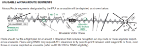
Do you check for unusable airway segments prior before you accept an IFR full route clearance?

bkspero

Line Up and Wait
Joined
Mar 5, 2012
Messages
652
Display Name
bkspero
I watched a Youtuber pick up an IFR clearance from Morristown NJ (MMU) to Eagle Creek Airpark (KEYE, Indianapolis IN). As is normal for the northeast, the route contained a fair number of separate VOR's and airways, including V12 between Harrisburg PA VOR (HAR) and Allegheny VOR (AGC). There was, however, an unusable segment on that airway (between COFAX and MIROY waypoints...it was possible to identify the exact date of the flight from other information shared in the video).

The pilot accepted the clearance as read to her and took off into the soup.

But that got me thinking. When being given a full route IFR clearance before a flight, I was not trained, and do not go through the full route looking for unusable segments prior to reading back (and therefore accepting) the clearance. But if one existed, I would be guilty of accepting an invalid clearance, wouldn't I?

What do you do when getting your full route clearance on the ground before a flight? Do you tell the clearance delivery controller to stand by while you check out the whole route? Or just read it back as I was taught? Or something else?

And if you do go through the full route on the ground prior to reading it back, what do you do in the air...for example when being given a full reroute clearance? Do you also have the controller stand by as you go through the new route segment by segment looking for spots that are unusable while also flying the airplane in IMC?

I recognize that you can check your filed and expected routes prior to picking up a clearance, and find unusable segments in those ahead of time. But my experience is that the actual routes assigned in the northeast is rarely the same as either those filed or expected. So the odds of catching unusable segments ahead of time seems to be less than good.
 
I don’t. I’m not sure how I would do that efficiently in the cockpit either. Especially assuming the prop is already spinning and I’m getting ready to taxi.
 
Check my filed and expected routes, for sure I'll do that while flight planning on the ground. But those squiggly lines on the enroute chart are pretty prominent. I'm pretty sure I'd notice that it exists somewhere near where I'll be so if ATC gives me something that hits it, I would probably remember that it is a potential issue. Would I catch it before I accepted the clearance rather than after? :dunno:

Maybe I would if I wrote down the possible segments during my initial planning, which I'm probably more apt to do after today.
 
I agree it's a PITA.

Best to just fly / plan an altitude in Center's space, as in Direct.
I pretty much know the nonfunctioning segments around NYC, Eastern PA and Metro Chi. The N 90 controller give you what htey give you and then they growl, "Whassa matter with that clearance...not good enough for you?"

And yes, I still do look at squigglies on the charts....but you fly enough you've seen the squigglies.
 
I won’t include one when I file, but in terms of a received clearance, I check my route in a general sense - I don’t want to be over the Atlantic Ocean 30 miles from shore! But I don’t specifically check for unusable airway route segments. If I notice one, I might say something or I might not. If it’s ok with ATC, and I can load it into my navigator/FMS, it’s ok with me.

I just read it back. No need for a “standby”. If it’s bad, I’ll call them back and say, “hey! That doesn’t work.”
 
Last edited:
What do you do when getting your full route clearance on the ground before a flight? Do you tell the clearance delivery controller to stand by while you check out the whole route? Or just read it back as I was taught? Or something else?
No need to tell them to standby, just read it back. If you find out later the route won't work for any reason, just call them back and tell them what the issue is.
 
There was, however, an unusable segment on that airway (between COFAX and MIROY waypoints...
I get what you're asking, but was the plane the youtuber flying a /G or /S? (Yes, old codes.) If they were GPS, then were the airways actually "unusable" or wouldn't that just be for VOR only aircraft? Now days you can fly routes even below the MEA if you're using GPS since there is no land based NAV you need to be concerned about receiving.

In reality, when ATC realizes you're on that path and there may be an issue, you'll get rerouted or you get and assigned heading to get you through the "unsuable" section.
 
Haven't run into that one yet, but I've rarely flown my cleared route in the NE. Think my record is 5 "advise ready to copy" in one flight from a fuel stop in NC to KGON. Pretty sure only 1 time in about 10 have I flown my initial clearance.
 
might as well throw in a search for any and all notoams along that route too. Yeah, like that's realistic :rolleyes:
LOL. You know where that comes from, right? I don’t hear it as much as I used to, but there’s this idea that’s been around for years that once you have read back an IFR clearance, you have accepted it … permanently and it is now etched in stone and you can no longer say, “no, not gonna do it.” Even if you haven’t even left the ground or been given an IFR release.
 
Haven't run into that one yet, but I've rarely flown my cleared route in the NE. Think my record is 5 "advise ready to copy" in one flight from a fuel stop in NC to KGON. Pretty sure only 1 time in about 10 have I flown my initial clearance.
A bit of thread drift…

I don’t fly up there that much but my record seems to be better. Not as far as GON, but I have done NC to PHL, ABE, FRG, and ISP (and back) with no enroute amendments. The PHL and ABE ones are probably irrelevant but one would (apparently incorrectly) think the short hop from ISP or FRG to GON would not be a big deal.
 
I get what you're asking, but was the plane the youtuber flying a /G or /S? (Yes, old codes.) If they were GPS, then were the airways actually "unusable" or wouldn't that just be for VOR only aircraft? Now days you can fly routes even below the MEA if you're using GPS since there is no land based NAV you need to be concerned about receiving.

In reality, when ATC realizes you're on that path and there may be an issue, you'll get rerouted or you get and assigned heading to get you through the "unsuable" section.

Once the route segment is charted as "unusable", it is unusable as an airway and the MEA for that airway is no longer evaluated for obstacles. Many of the unusable victor route segments are overlaid with a T route, which will have a G MEA, so the T route can be used. If one looks at the airway source found in NASR, the MEA for the unusable victor route segment is not published as a value, but there is a note indicating "unusable". FAA HQ is adamant that if an airway is charted as "unusable", it means what it says. If one is flying the route using GPS as a substitute means of navigation for VOR, it may be flown as a "point to point" route, but the "point to point" MIA/MVA would apply for those segments as there isn't a published MEA. The Low Altitude Enroute charts used to have notes indicating that a route or radial was unusable except for GPS equipped aircraft. These notes were eventually removed. ATC seems to ignore the "unusable" segment status. It has been a long time since many of us have actually used VOR for navigation on Victor Airways. I have argued at the ACM that rather than charting the routes as unusable, the airways should be modified to remove the segment as there is little likelihood of the VOR issue with the route from being resolved. You can read about the ACM discussion of the topic at https://www.faa.gov/air_traffic/fli...a/RDs/19-01-335-Charting-Unusable-Airways.pdf
 
I watched a Youtuber pick up an IFR clearance from Morristown NJ (MMU) to Eagle Creek Airpark (KEYE, Indianapolis IN). As is normal for the northeast, the route contained a fair number of separate VOR's and airways, including V12 between Harrisburg PA VOR (HAR) and Allegheny VOR (AGC). There was, however, an unusable segment on that airway (between COFAX and MIROY waypoints...it was possible to identify the exact date of the flight from other information shared in the video).

The pilot accepted the clearance as read to her and took off into the soup.

But that got me thinking. When being given a full route IFR clearance before a flight, I was not trained, and do not go through the full route looking for unusable segments prior to reading back (and therefore accepting) the clearance. But if one existed, I would be guilty of accepting an invalid clearance, wouldn't I?

What do you do when getting your full route clearance on the ground before a flight? Do you tell the clearance delivery controller to stand by while you check out the whole route? Or just read it back as I was taught? Or something else?

And if you do go through the full route on the ground prior to reading it back, what do you do in the air...for example when being given a full reroute clearance? Do you also have the controller stand by as you go through the new route segment by segment looking for spots that are unusable while also flying the airplane in IMC?

I recognize that you can check your filed and expected routes prior to picking up a clearance, and find unusable segments in those ahead of time. But my experience is that the actual routes assigned in the northeast is rarely the same as either those filed or expected. So the odds of catching unusable segments ahead of time seems to be less than good.
What are the odds ATC would assign an unusable segment? If this is your logic you need to check the FTC NOTAM too.
 
Last edited:
I watched a Youtuber pick up an IFR clearance from Morristown NJ (MMU) to Eagle Creek Airpark (KEYE, Indianapolis IN). As is normal for the northeast, the route contained a fair number of separate VOR's and airways, including V12 between Harrisburg PA VOR (HAR) and Allegheny VOR (AGC). There was, however, an unusable segment on that airway (between COFAX and MIROY waypoints...it was possible to identify the exact date of the flight from other information shared in the video).

The pilot accepted the clearance as read to her and took off into the soup.

But that got me thinking. When being given a full route IFR clearance before a flight, I was not trained, and do not go through the full route looking for unusable segments prior to reading back (and therefore accepting) the clearance. But if one existed, I would be guilty of accepting an invalid clearance, wouldn't I?

What do you do when getting your full route clearance on the ground before a flight? Do you tell the clearance delivery controller to stand by while you check out the whole route? Or just read it back as I was taught? Or something else?

And if you do go through the full route on the ground prior to reading it back, what do you do in the air...for example when being given a full reroute clearance? Do you also have the controller stand by as you go through the new route segment by segment looking for spots that are unusable while also flying the airplane in IMC?

I recognize that you can check your filed and expected routes prior to picking up a clearance, and find unusable segments in those ahead of time. But my experience is that the actual routes assigned in the northeast is rarely the same as either those filed or expected. So the odds of catching unusable segments ahead of time seems to be less than good.

I live with all the deplorables. My full clearance is "as filed." My "as filed" is -D->. If there's an unusable segment, I'm not navigating by VOR anyway. Are there currently unusable T and Q routes?
 
  • Like
Reactions: WDD
I don’t fly up there that much but my record seems to be better.
You're lucky! I'm with @Hang 4 and when I flew out of FRG for a few decades I just expected to get a route change.

And actually sticking to the thread, that's probably why I didn't check the routes. I knew the basic inital stuff they'd give me to get out of the NYC area. Then once in the air you could look ahead and question anything that didn't look right. But usually before you had a chance to ask, it got changed. And more than once when handed over I've been asked "where are you going?" That would be followed by with some comment about how stupid the route the computer spit out and then told to go Direct to some fix that took a big chunk off the route.
 
That would be followed by with some comment about how stupid the route the computer spit out and then told to go Direct to some fix that took a big chunk off the route.
I've definitely gotten direct to some fix already on my flight plan. But I don't think of that as a route amendment.
 
I had a devil of a time leaving Colorado Springs in the F-15 one time. We didn't have GPS so "technically" all we could file/accept was TACAN to TACAN navigation. I filed to Nellis AFB (Vegas) via TACAN routing. I started up (we also don't have a battery so you are burning precious JP-8 while getting clearances) and called. They had an amended route full of VORs (which we also don't have). I read it back, check it, call them back and say I can't accept that because I don't have VOR in my jet. "standby.... ok here's your new clearance: blah..." Check that one - ALSO full of VORs. Call back again and say the same thing. The guy was all put out and said "Well, what clearance CAN you accept?" <pause> "Uh..... I can accept 'As filed' - that's why I filed it that way". <pause> "Ok, cleared as filed"

I know the automated system probably changed it all around but that took a long time to sort out and we were short on fuel getting to Nellis.... fun fun fun!
 
I get what you're asking, but was the plane the youtuber flying a /G or /S? (Yes, old codes.) If they were GPS, then were the airways actually "unusable" or wouldn't that just be for VOR only aircraft?
In fact there was another unusable segment on the Youtuber's clearance route that fits the situation you describe. The difference between the two segments is that the one I didn't mention had a coincident T route along with the Victor route, and the chart contains a note saying that only the Victor airways were unusable in that segment (the T route is usable). So there is provision for GPS navigation through an otherwise unusable segment when its charted. But I don't see a basis for ATC to approve GPS navigation through an unusable segment of a Victor airway when it isn't charted.

I guess one could rely on the authority of ATC to approve transit. But that makes me a little squeamish. Sounds ripe for the FAA to claim that it's a violation because it's the responsibility of the PIC to fly legally, and that ATC approval is immaterial.
 
But I don't see a basis for ATC to approve GPS navigation through an unusable segment of a Victor airway when it isn't charted.
You aren't flying the airway. You're flying GPS of which two defined way points are part of your route - and happen to be on an unusable airway.
I can file/get a route with ___ -> LESSY -> PMM -> ENKOW -> PETTY -> ___ and get cleared and fly it all day long (unless I'm in the way of arrivals to ORD). That's on an unusable segment of V170. But no different than flying TVC -> ISQ where nothing is charted. (The VORs, not the airports)
 
So there is provision for GPS navigation through an otherwise unusable segment when its charted. But I don't see a basis for ATC to approve GPS navigation through an unusable segment of a Victor airway when it isn't charted.
Never heard of point-to-point navigation? The FAA has. This is from the final edition of the Chart Users Guide:
1753878981085.png
There's an interesting oddity on the difference between airway and point-to-point I came across when I was working on my Minimum Altitudes article for IFR Magazine. If your route is an airway, ATC can't clear you below the MEA. But if you are point to point on the exact same route, they can clear you down to their MVA or MIA.

IOW, "unusable airway segment" literally means the airway qua "airway" is not usable, not that there is something wrong with being in the area.
 
I do like the area of the country (ATL) I live in when it comes to routing. Any routing I get on the ground - except for direct/vectors - will change when I'm in the air, where it will change to "direct". I've never yet flown outbound to a VOR fix or flown a Victor highway. Heck, one time I was getting a clearance with three or so "interesting" fixes, and after I read it back, the controller said "wait a minute, this makes no sense. Hold on." Came back later and said "fly xx after entering controlled airspace, then direct".

The only fixes I get are with Arrivals and/or Approaches.
 
I had a devil of a time leaving Colorado Springs in the F-15 one time. We didn't have GPS so "technically" all we could file/accept was TACAN to TACAN navigation. I filed to Nellis AFB (Vegas) via TACAN routing. I started up (we also don't have a battery so you are burning precious JP-8 while getting clearances) and called. They had an amended route full of VORs (which we also don't have). I read it back, check it, call them back and say I can't accept that because I don't have VOR in my jet. "standby.... ok here's your new clearance: blah..." Check that one - ALSO full of VORs. Call back again and say the same thing. The guy was all put out and said "Well, what clearance CAN you accept?" <pause> "Uh..... I can accept 'As filed' - that's why I filed it that way". <pause> "Ok, cleared as filed"

I know the automated system probably changed it all around but that took a long time to sort out and we were short on fuel getting to Nellis.... fun fun fun!
...and that is another example of exactly what is wrong with our ATO system....Actually sounds like the USN to me....fun fun fun.
 
Is it still common for an airway to be part of your clearance even if you're /G ? I'm trying to remember a time I got one and I'm coming up with nothing. I pretty much always just file direct and occasionally I'll get a waypoint or vector to route me around something.
 
Is it still common for an airway to be part of your clearance even if you're /G ? I'm trying to remember a time I got one and I'm coming up with nothing. I pretty much always just file direct and occasionally I'll get a waypoint or vector to route me around something.
Not being /G limits you to Victor airways or other VOR-based routings (thanks @Larry in TN), but nothing about being /G prevents you from being assigned them where ATC uses them.

The use of airways is a matter of ATC routing preferences. I can travel from North Carolina to south Florida without ever being on an airway. I can't travel from North Carolina to most anywhere north of Richmond VA without being assigned them.

And remember that T and Q routes were designed specifically for GPS-equipped aircraft.
 
Last edited:
The use of airways is a matter of ATC routing preferences. I can travel from North Carolina to south Florida without ever being on an airway. I can't travel from North Carolina to most anywhere north of Richmond VA without being assigned them.
I have the exact same experience. I use the SSI VOR to keep from going too far over the ocean. 50% of the time going south, I get "direct FIN" which I refuse. No issue doing that though. You can go pretty much where ever you want >D in the south east. (except FL going south and around ATL and CLT.)
 
But I don't see a basis for ATC to approve GPS navigation through an unusable segment of a Victor airway when it isn't charted.

I guess one could rely on the authority of ATC to approve transit. But that makes me a little squeamish. Sounds ripe for the FAA to claim that it's a violation because it's the responsibility of the PIC to fly legally, and that ATC approval is immaterial.

Not for ATC to decide as they are not the PIC. And sure you list off a bunch of codes when you file your Flight Plan, but that may not reach the Controller or they may not care or have the time to look. OR... he or she has been around enough to know you're using GPS and the system spit out a VOR route with issues *IF* you were using the VOR transmission. But in fact, you're justusing the VORs as GPS Waypoinst and it is irrelevant that you can't receive VOR xxx 30 miles out to the SW. GPS can be legally stubstituted for a VOR, even if that VOR is INOP.
 
Is it still common for an airway to be part of your clearance even if you're /G ?
Is it. We are on airways all of the time. Almost every flight. The airways provide a structure to the traffic flows.

Not being /G limits you to Victor airways
Not quite. You can do direct from navaid to navaid, you just have to be within the service volumes.
 
You aren't flying the airway. You're flying GPS of which two defined way points are part of your route - and happen to be on an unusable airway.
I can file/get a route with ___ -> LESSY -> PMM -> ENKOW -> PETTY -> ___ and get cleared and fly it all day long (unless I'm in the way of arrivals to ORD). That's on an unusable segment of V170. But no different than flying TVC -> ISQ where nothing is charted. (The VORs, not the airports)
^^^^^ This
 
Never heard of point-to-point navigation? The FAA has. This is from the final edition of the Chart Users Guide:
View attachment 143411
There's an interesting oddity on the difference between airway and point-to-point I came across when I was working on my Minimum Altitudes article for IFR Magazine. If your route is an airway, ATC can't clear you below the MEA. But if you are point to point on the exact same route, they can clear you down to their MVA or MIA.

IOW, "unusable airway segment" literally means the airway qua "airway" is not usable, not that there is something wrong with being in the area.
You aren't flying the airway. You're flying GPS of which two defined way points are part of your route - and happen to be on an unusable airway.
I can file/get a route with ___ -> LESSY -> PMM -> ENKOW -> PETTY -> ___ and get cleared and fly it all day long (unless I'm in the way of arrivals to ORD). That's on an unusable segment of V170. But no different than flying TVC -> ISQ where nothing is charted. (The VORs, not the airports)

In the case I was referencing the pilot was cleared to fly the Victor airway (V12), not point to point between waypoints on the airway. Are you saying that filing /G and being assigned a Victor airway automatically qualified that pilot for point to point navigation through the unusable segment? That seems implausible. Or that a pilot can rely on ATC to amend a Victor airway clearance to point to point navigation when an unusable segment exists on the airway (again seems implausible).

Or is there some other point that I am missing?
 
Are you saying that filing /G and being assigned a Victor airway automatically qualified that pilot for point to point navigation through the unusable segment? That seems implausible.
Think about what you're saying. You've got a Victor Airway that is VOR navigation and an unusable segment PROBABLY due to reception of the VOR signal. Yet you're saying it is "implausable" to fly from VOR ABC to VOR DEF with a GPS because of that VOR reception issue.

If you really are unclear on this, maybe a quick review of AC 90-108 (original 03/2011, CHG 1 04/2015) will clarify why we're saying it is an non issue in an IFR GPS equipted aircraft.
 
In the case I was referencing the pilot was cleared to fly the Victor airway (V12), not point to point between waypoints on the airway. Are you saying that filing /G and being assigned a Victor airway automatically qualified that pilot for point to point navigation through the unusable segment? That seems implausible. Or that a pilot can rely on ATC to amend a Victor airway clearance to point to point navigation when an unusable segment exists on the airway (again seems implausible).

Or is there some other point that I am missing?
I guess we may have to go back a step. What do you think “unusable” means in this context? I mentioned earlier that, "unusable airway segment" literally means the airway qua "airway" is not usable, not that there is something wrong with being in the area. It doesn’t mean “there be dragons there” or there’s some prohibition on flying along that route.

OK, ATC instructs, “intercept V123.” It’s an unusable segment. I guess you might legitimately reply “unable” because it’s “unusable.” I probably would if I were only VOR capable. It’s most likely a VOR reception issue which is why the FAA says it’s okay to fly it point to point with RNAV. I might question it if I were flying at its MEA below the OROCA just in case it’s not solely about reception (“that shows as unusable; what’s your MVA over here?”). Beyond that, I really don’t care. It’s just a charted point to point route to me.
 
Are you saying that filing /G and being assigned a Victor airway automatically qualified that pilot for point to point navigation through the unusable segment?
This really is very high up on the importance scale, more of a technicality. I doubt it's something to which most controllers give much thought.

If you're approaching the unusable segment and haven't received a revised clearance, just ask for one. Easiest method, for a flight with RNAV, would be to request direct to the fix at the end of the unusable segment.
Larry, would you even bother? If ATC didn't issue a revised clearance, they apparently don't know or don't care.
 
I remember way back when the A320's came out. They always flew non precision approach's through the fms. The only approach's flown by reference to radio signals was with ILS's.

A NWA crew shot a NDB approach somewhere late at night. Problem was that the NDB was OTS. FAA at first tried certificate action against the crew. But later backed down.
 
Larry, would you even bother? If ATC didn't issue a revised clearance, they apparently don't know or don't care.
I was wondering the same thing. I very rarely have the en-route chart up, so not sure I'd even be aware it was there, unless I was on my filed route. In the OP's scenario, I'd see it when I filed, but if I got an amended route after engine start, I would not have thought to check it beyond looking at a very zoomed out view to see if it had a major change from the original route to see if it impacted fuel planning or arrival time.
I'd be really curious if a controller has visibility to that segment being unusable.
 
Back
Top