KJFZ approach entry question

dmspilot

Final Approach
Joined
Oct 20, 2006
Messages
6,772
Display Name
DISPLAY NAME
This question is making the rounds on social media and am a bit stunned by the number and popularity of what I believe to be wrong answers. I'm wondering if POA will do a better job.

You're south of BLF and given the clearance, "N12345, cleared direct Bluefield, cross Bluefield at 6,000, cleared Localizer 25 approach." Upon reaching the VOR, what do you do?
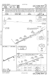
09221LD25.png
 
I saw that on one of my feeds as well.

The problem is that the hold is not depicted as a hold in lieu of procedure turn, but has the thin line of an arrival hold. This means it is not technically a Procedure Turn, and therefore the NoPT note is meaningless - as there is no PT depicted.

The pedantically correct answer in this case is that the procedure wasn't designed to be coming at from anything other than the airways. So if you're "south" then you aren't on an airway and you need to discuss it with ATC.

But other than that, the "correct" answer in this case depends on where exactly "to the south" you're coming from. If "from the south" means "on the 180 radial" then the answer is to make a left turn upon crossing the BLF VOR and intercept the 244 radial and fly the approach. You have 16.5 nm to get back on the radial. Up to 120 degrees of turn is allowed at an IAF on an ILS.

But if "from the south" just means anywhere south-ish of the facility and you are really on, say, the 190 radial, then that's more than 120 degrees of turn and you're in a no-mans land where you really don't have a good, rule-compliant answer. Certainly the practical answer is to fly the hold entry as if it was a HILPT, and that would obviously work and be safe. But it's not really correct.

Since the NoPT note doesn't make sense, I imagine it was intended to be the "procedure NA for arrivals on BLF airway radials 239 CW 288" note but for whatever reason the note was misapplied.

To further complicate the issue, the holding pattern CAN'T be a HILPT or depicted as such, since HILPTs aren't positioned at the beginning of an initial segment, but at the beginning of an intermediate segment. There's no reason you wouldn't be ABLE to fly one as depicted, but the TERPS doesn't provide for them to be put a the beginning of an initial segment.
 
Last edited:
I’m game. With that clearance, If south of BLF, (on any radial >122), I’d plan on a teardrop course reversal to intercept the localizer.
But I’d probably ask if it would be ok to just turn left to intercept, since you have over 16 miles to get established, and Garmin would probably give you turn anticipation to do so.
 
Russ answered while I was puzzling over why there's no depicted PT associated with the note and what is the relevance for GZG being the center of the 7000 feet MSA. There's no route from there to the IAF, so how is that going to help anybody? If I can't trust the chart, can I trust "Cross Bluefield at 6000 feet"? Lost comm, I'm staying high and doing the hold. Unless ATC satisfies my questions.
 
Russ answered while I was puzzling over why there's no depicted PT associated with the note and what is the relevance for GZG being the center of the 7000 feet MSA. There's no route from there to the IAF, so how is that going to help anybody? If I can't trust the chart, can I trust "Cross Bluefield at 6000 feet"? Lost comm, I'm staying high and doing the hold. Unless ATC satisfies my questions.

The MSA one is easier to answer, it is correctly depicted.

For an ILS or a LOC, the MSA must be based on the "primary omnidirectional facility in the area", as long as it is within 30 nm of the airport. GZG is about 20 nm while BLF is about 32 nm. So BLF is too far. And at least you would have GZG tuned in anyway for use on the missed approach.

If there are no omnidirectional facilities within 30 nm, then the MSA is centered on the airport. This is becoming more and more of an issue with VOR decommissioning.
 
I confess I would have answered fly it like a HILPT. That said, if in doubt would a question to ATC to clarify if they are expecting you to fly the HILPT based upon your present position South of the fix be inappropriate?
 
I confess I would have answered fly it like a HILPT. That said, if in doubt would a question to ATC to clarify if they are expecting you to fly the HILPT based upon your present position South of the fix be inappropriate?

A question to ATC to clarify anything you're not sure about is NEVER inappropriate.
 
This question is making the rounds on social media and am a bit stunned by the number and popularity of what I believe to be wrong answers. I'm wondering if POA will do a better job.
It would also be interesting to see what the answers given (here and there) are broken down between those that flew IFR before there was a HILPT and those that got their training after? :eek: :cool:
 
It would also be interesting to see what the answers given (here and there) are broken down between those that flew IFR before there was a HILPT and those that got their training after? :eek: :cool:
I’m in that thread. I’m not sure that before/after is the answer. The most common wrong answers by far begin with the incorrect belief that there is a HILPT on that chart.

What I wonder is how many of those who think it’s a HILO would be able to fly it when it doesn’t show up in their GPS database.

I may use this approach in the next iteration of my IPC quiz!
 
Last edited:
Certainly the practical answer is to fly the hold entry as if it was a HILPT, and that would obviously work and be safe. But it's not really correct.
That’s true, but one can always request “one turn in the published hold at Bluefield to reverse course.” (@tsts4, does that answer your question?)

I think like 4 people knew it was arrival hold and no one pointed out why it can’t be a HILO.

Side note. One of the approaches into my home base is beginning the process of a change initiated by ATC. Just a few weeks ago one of the RDU controllers and I discussed the HILO vs Arrival Hold issue.
 
Last edited:
It would also be interesting to see what the answers given (here and there) are broken down between those that flew IFR before there was a HILPT and those that got their training after? :eek: :cool:
That could be a very long time ago…

1782477167260.png
 
Last edited:
That’s true, but one can always request “one turn in the published hold at Bluefield to reverse course.” (@tsts4, does that answer your question?)

I think like 4 people knew it was arrival hold and no one pointed out why it can’t be a HILO.

Side note. One of the approaches into my home base is beginning the process of a change initiated by ATC. Just a few weeks ago one of the RDU controllers and I discussed the HILO vs Arrival Hold issue.
Which Approach? Which episode?
 
This question is making the rounds on social media and am a bit stunned by the number and popularity of what I believe to be wrong answers. I'm wondering if POA will do a better job.

You're south of BLF and given the clearance, "N12345, cleared direct Bluefield, cross Bluefield at 6,000, cleared Localizer 25 approach." Upon reaching the VOR, what do you do?

View attachment 152905
How we doin’ so far?
 
Which Approach? Which episode?
I'm not sure what you mean by "episode." The approach in the early drafting stage of a change is the TTA RNAV 21. It's related to the pending proposal to change the dimensions of the RDU Class C.
 
What would you do if you received a clearance that should never been issued? Thats the real question in this scenario.
 
I'm not sure what you mean by "episode." The approach in the early drafting stage of a change is the TTA RNAV 21. It's related to the pending proposal to change the dimensions of the RDU Class C.
I assumed the RDU controller was on an opposing bases or whatever that is called episode
 
Centers can vector to final. There are rules. The final has to be displayed on there video map and there are some distance limitations. I’ll get back on that.
Altitude limitations is my thought. Also the VOR is out of service for this approach and approved RNAV is required. Probably because center can’t vector. BLF is beyond service limit for the LOC and NAYIC is probably ~2200 AGL
 
Last edited:
Altitude limitations is my thought.
Here it is.

e. EN ROUTE. The following provisions are required before an aircraft may be vectored to the final approach course:

1. The approach gate and a line (solid or broken), depicting the final approach course starting at or passing through the approach gate and extending away from the airport, be displayed on the radar scope; for a precision approach, the line length must extend at least the maximum range of the localizer; for a nonprecision approach, the line length must extend at least 10 NM outside the approach gate; and

2. The maximum range selected on the radar display is 150 NM; or

3. An adjacent radar display is set at 125 NM or less, configured for the approach in use, and is utilized for the vector to the final approach course.
 
What I wonder is how many of those who think it’s a HILO would be able to fly it when it doesn’t show up in their GPS database.
Is JFZ something you can use as a long XC? Might be interesting to see what they do in real life if you can set up the scenario where you're coming from the south. :D
 
But if "from the south" just means anywhere south-ish of the facility and you are really on, say, the 190 radial, then that's more than 120 degrees of turn and you're in a no-mans land where you really don't have a good, rule-
Is there a 120-degree limitation that applies here? The only 120-degree maximum angle that I am aware of is contained in TERPS, which specifically establishes procedure design criteria and is not controlling from a pilot standpoint. As far as I know, a pilot is not required to intercept a course at an angle of 120 degrees or less. What am I missing?

In this hypothetical example, the approach chart contains an ambiguous NoPT note when, in fact, neither a PT or HILPT is depicted. Given that, I agree with your hypothetical-world solution: cross BLF at 60, execute a left turn to intercept BLF R244, and then fly the remainder of the procedure as published. A real-world solution would include resolving the issue with ATC prior to accepting the clearance.
 
Interesting. One of the (knowledgeable) thread participant asked about it through the gateway. This was the response:
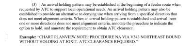
When the procedure published with the note, there wasn't any 8260.19 guidance for arrival holding, so the HIL note was used. There is guidance in the .19 now, and should the procedure be amended, that note should be changed to current format exampled in the .19: Example: ?CHART PLANVIEW NOTE: PROCEDURE NA VIA V343 NORTHEAST BOUND WITHOUT HOLDING AT JOXIT. ATC CLEARANCE REQUIRED​

Here's the relevant language from the cited TERPS volume. As the marginal bars o the left indicate, it first appeared in the most recent iteration (January 2025):
1782501445337.png
Seems smart. Arrival holds are not particularly common, so this solves both the lack of knowledge and the operational issues.
 
Is there a 120-degree limitation that applies here? The only 120-degree maximum angle that I am aware of is contained in TERPS,
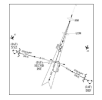
Not 120, but the controller manual (7110.65) contains a limitation on >90° vectored intercepts unless one of the exceptions applies. This will bring you directly to Figure 4-8-3 which includes an example - in this photo, the extreme example is that aircraft #2 ant be cleared to XYZ.
1782502516125.png
 
The most popular response elsewhere was to fly the HILPT/procedure turn, even though there isn't one. My answer was to fly to the VOR and turn inbound. Even if the turn is more than 120°, the 120 degree rule is a TERPS rule not an operational one. Being south means being off-airways which means receiving basic radar service, making the long turn basically a pseudo-vector.

In reality you'd never get a clearance like the one posed in the scenario. First it's just not a realistic scenario that would happen: if a controller can pseudo-vector you to the IAF, then they can vector you to the approach course. Second is the 90 degree vectoring guidance mentioned above.

I confess I would have answered fly it like a HILPT. That said, if in doubt would a question to ATC to clarify if they are expecting you to fly the HILPT based upon your present position South of the fix be inappropriate?
The hold is not part of the approach: it is not in bold nor is it on the profile view. Since it is not part of the approach, an approach clearance does not allow you to fly the hold. I'd argue it would be a PD to turn outbound at the VOR.
 
Last edited:
Not 120, but the controller manual (7110.65) contains a limitation on >90° vectored intercepts unless one of the exceptions applies. This will bring you directly to Figure 4-8-3 which includes an example - in this photo, the extreme example is that aircraft #2 ant be cleared to XYZ.
This is true: ATC should not issue a clearance that results in an intercept angle greater than 90 degrees in this example, and I don't recall ever having received such a clearance. This scenario seems to be a hypothetical situation posed to highlight the NoPT issue with the charted procedure, and is unlikely to have been encountered on an actual flight. I have been searching for a document with language that prohibits a pilot from intercepting a course or route at an angle greater than 120, without success.
 
This is true: ATC should not issue a clearance that results in an intercept angle greater than 90 degrees in this example, and I don't recall ever having received such a clearance. This scenario seems to be a hypothetical situation posed to highlight the NoPT issue with the charted procedure, and is unlikely to have been encountered on an actual flight. I have been searching for a document with language that prohibits a pilot from intercepting a course or route at an angle greater than 120, without success.
I don’t think you will.
 
Here it is.

e. EN ROUTE. The following provisions are required before an aircraft may be vectored to the final approach course:

1. The approach gate and a line (solid or broken), depicting the final approach course starting at or passing through the approach gate and extending away from the airport, be displayed on the radar scope; for a precision approach, the line length must extend at least the maximum range of the localizer; for a nonprecision approach, the line length must extend at least 10 NM outside the approach gate; and

2. The maximum range selected on the radar display is 150 NM; or

3. An adjacent radar display is set at 125 NM or less, configured for the approach in use, and is utilized for the vector to the final approach course.
But that doesn’t mean the conditions are met for that approach due to terrain and distance from the radar antenna. Not all US airports with instrument approaches are served by radar. Many smaller or rural airports with radar coverage do not have coverage sufficient for vectors to final. The aircraft are cleared to a published approach fix/segment and radar service is terminated.
 
Last edited:
The most popular elsewhere was to fly the HILPT/procedure turn, even though there isn't one. My answer was to fly to the VOR and turn inbound. Even if the turn is more than 120°, the 120 degree rule is a TERPS rule not an operational one.
Realistically the issue is intercepting the course in time to descend to the next fix. That geometry is probably beyond what most of us would consider doing “on the fly,” and the other options would be getting behind the approach and playing catch-up or negotiating a turn with ATC, whether it be the hold or a vector.
 
Interesting. One of the (knowledgeable) thread participant asked about it through the gateway. This was the response:
When the procedure published with the note, there wasn't any 8260.19 guidance for arrival holding, so the HIL note was used. There is guidance in the .19 now, and should the procedure be amended, that note should be changed to current format exampled in the .19: Example: ?CHART PLANVIEW NOTE: PROCEDURE NA VIA V343 NORTHEAST BOUND WITHOUT HOLDING AT JOXIT. ATC CLEARANCE REQUIRED​

Here's the relevant language from the cited TERPS volume. As the marginal bars o the left indicate, it first appeared in the most recent iteration (January 2025):
View attachment 152926
Seems smart. Arrival holds are not particularly common, so this solves both the lack of knowledge and the operational issues.

May a feeder route be located between the IAF and the IF on an IAP?
 
But that doesn’t mean the conditions are met for that approach due to terrain and distance from the radar antenna. Not all US airports with instrument approaches are served by radar. Many smaller or rural airports with radar coverage do not have coverage sufficient for vectors to final. The aircraft are cleared to a published approach fix/segment and radar service is terminated.
I took your question as can Centers do it. Of course there needs to be Radar coverage. @PastZTL , you still around, do you know if there is good coverage up around KJFZ?
 
Back
Top