
Ed Haywood
Final Approach
He killed himself.
So do you think it is as simple as he failed to closely read the notes, perhaps because he was rushed on preflight?

He killed himself.
Failed to read the notes for whatever reason (or chose to ignore them, but I’d bet the former,) didn’t understand his autopilot, didn’t understand that with a VNAV-capable navigator he might still need to fly LNAV minimums and what that actually means, didn’t understand what straight-in means, didn’t understand that following the magenta line below MDA isn’t necessarily the right thing to do…lots of things, mostly training/learning related.So do you think it is as simple as he failed to closely read the notes, perhaps because he was rushed on preflight?
So explain how you “lose sight” of something when you fly a straight line towards it.It’s not, but you do you.

It comes back to one point - why choose this approach in the first place versus the RNAV-E?Apparently your definition of “straight -in” doesn’t match the FAA’s. And I don’t think you’ll get them to change theirs to match yours.
Asked and answered. You can have “the runway” in sight but not the approach end, which may be difficult to discern exactly from that distance.So explain how you “lose sight” of something when you fly a straight line towards it.
As I noted earlier, it’s probably more misunderstanding of those factors rather than those factors themselves.And I’ll bet money it’s because the “straight-in” nature of the name itself is suggestive of a shallower approach. As defined in the instrument procedure handbook, we’re taught to believe that a circling-only approach is generally (big caveat there) required when the slope exceeds 400’/nm. If you do the math for this approach, it was set up to eke in under that from the FAF, despite the obstructions.

If I'm recalling correctly, I think you mathed it as just under 4°, which is below the TERPS category B maximum straight-in glide path angle of 4.2°Right, and at that point, it’s really not within what’s considered straight-in criteria. I posted the resultant angles far earlier in the thread.
That's doubtful. Things like this are rarely that simple. Swiss cheese lining up and all that. Even the approach being NA at night is a little bit of a red herring since he could have legally circled to runway 14 and have the same result. Maybe didn't set the local altimeter and thought he was above the MDA and didn't have the piece of common mountain VFR knowledge that if you can't see your target over a ridge, you will hit the ridge, and it's application to the visual segment of an approach with obstacles.So do you think it is as simple as he failed to closely read the notes, perhaps because he was rushed on preflight?
If I'm recalling correctly, I think you mathed it as just under 4°, which is below the TERPS category B maximum straight-in glide path angle of 4.2°
Which one reason is why it’s circling only at night.9575’ (2694) - 7.75° (the same angle as the RNAV-E)
Totally, no argument there. To fly this as a straight-in, CDFA at night, below MDA was the critical error. I don’t think I’ve ever postulated otherwise.Which one reason is why it’s circling only at night.
Like I said, I think the chain started with training, and has less to do with approach design than gross misunderstandings of approach design.I’m trying to think more systemically - back to the initial decision-making process that started the chain.
I wish I could get empirical data on the number of instrument-rated pilots that would have favored this approach, given no prior knowledge, and going by the big-picture data (name and apparent glidepath angle).Like I said, I think the chain started with training, and has less to do with approach design than gross misunderstandings of approach design.
Given what I’ve seen of pilot knowledge, and having been told by numerous people that if there’s a discrepancy between what the approach chart says and where the procedure in the box takes you that they’d follow the box instead of the chart, I’d bet a majority would think that following the magenta line, either vertically or laterally, provides protection on this approach.I wish I could get empirical data on the number of instrument-rated pilots that would have favored this approach, given no prior knowledge, and going by the big-picture data (name and apparent glidepath angle).
Then get data on how the decision would have changed after analysis, from a group that read the chart while enroute in the airplane, and a group that read it on the ground prior to flight.
My hypothesis is that most would favor the straight-in until careful analysis and comparison. How good the analysis is comes down to a lot of things (training being a big one of them). That’s a big study and it’s a rhetorical exercise anyway, but it’s where I’m going with my line of thought.

TBF, the FAA probably assumed a pilot would not fly a procedure at night which was NA at night.
What you're missing is that the approach is NOT "NA at night". Straight in or circling to 32 is. The approach is legal to fly at night provided you circle to 14 southwest of the runway (right traffic).You guys are a lot more knowledgeable than I am, but I don't understand some of the debate here. Seems pretty simple. The approach was not legal at night. The pilot tried flying it at night. It killed him. Am I missing something?
For sure... And as much as we all love to think we're steely eyed missile men that eagles admire, damn good pilots get killed by human factors stuff all the time.But it’s perhaps telling that, even within a group of Monday morning quarterbacks sitting safely at home, there seem to be at least a few comments about this chart that are contrary to what the chart says.
What regulation says you can't use +V below MDA?It is only risky if you don't follow the chart and violate regulations and use +V below the MDA. All approaches are risky if you ignore the chart and violate regulations.
I think it's a bit ironic that you're simultaneously seeming to say that CDFA to the runway is bad, but dive and drive is also bad. If you can't do CDFA to the runway, then you are doing to dive and drive (or really, drive and dive).The problem I see is that people are trying to blame the chart and the availability of CDFA stabilized approach guidance down to the MDA (not down to the runway). This one is definitely less tolerant of error, but you could probably find similar errors in most fatal accidents where someone deviates from the IAP. So is the answer to get rid of instrument approaches, or just the ones I don't like? Or maybe the FAA is all wrong about stabilized approaches and we should go back to dive and drive?
It sounds like this approach is probably going to go away (it's already NOTAMed NA), which is quite telling in itself.Pilots make mistakes. Can we modify or replace this approach so that there is a greater margin for safety? Can we have an extra help from the autopilot?
On this one, it seems like maybe having some obstacles on the profile view would be appropriate... It'd certainly drive home the point that you need to "drive" for a bit.The angle to meet straight-in criteria is calculated from the FAF, which can strongly insinuate that it’s a relatively shallow approach, but the reality is that it’s effectively much steeper. I question whether the symbology on the chart goes far enough to describe the magnitude of the obstacles and the resultant, safe glidepath needed to overcome them.
Given the history of this approach, where it was apparently designed to be able to have Category C aircraft use it and that's why WDCHK was placed where it is, and now the C minimums are gone anyway - What would it look like if we used the 4.2º maximum final for Category B?So why make it such a thin margin? Why rely so heavily upon all the “gotcha” traps described above that require superior knowledge and skill to overcome? The flight test people figured out that this would be risky.
Considering the loss of visual on a CDFA at WDCHK and having to continue at MDA beyond, designating this approach as a straight-in is a misnomer. There’s basically one use-case for this as a legit straight-in approach, and that’s as a “cloud break” procedure (terminology not really used in the US) where you break out into (daytime) VMC above MDA and before WDCHK, then bracket east to continue a safe, stabilized, and relatively shallow descent as insinuated by the nomenclature describing the approach.
So either notate that more strongly, or raise the MDA and/or move WDCHK and call it what it is.
For an approach procedure, the FAA certainly bears some responsibility.We agree it's risky, but the question becomes, who is responsible for managing that risk?
I think it's more of an exercise issue than anything. It has been a looooooong time since I flew an approach that wasn't vertically guided, because vertically guided approaches are available at nearly every BFE, podunk municipal type of place today. If you asked me a week ago how to fly this on Garmin equipment I'd have said "Push APR when you're cleared for the approach." In this case, that would have flown me into the mountain. NAV for lateral and VNAV (ALTS) with 9100 bugged for vertical is probably a more correct way to fly it, now that I've had days to think about it...If you are saying equipment knowledge, I still think understanding +V and how to stop a descent are pretty basic things. The fact that people don't understand those is a training failure and not the fault of the approach designers or equipment.
I don't know if I have heard exactly the same or whether this is a factor, but the main sign of autopilot overdependence I see in recurrent training is the loss of the learned skill of anticipation - asking, "what's next and what do I have to do when I get there?" That was the basic thrust of the "George Doesn't Know" article I did for IFR Magazine in 2024 (paywall, or I'd supply a link). Basically, the pilot gets used to letting George take care of it and fails to monitor what is going on. Set it and forget it.Given what I’ve seen of pilot knowledge, and having been told by numerous people that if there’s a discrepancy between what the approach chart says and where the procedure in the box takes you that they’d follow the box instead of the chart, I’d bet a majority would think that following the magenta line, either vertically or laterally, provides protection on this approach.
I'll admit to being a horribly out of currency instrument rated pilot without so much as a minute of hood time in years, but why am I thinking an RNAV 32 is only for landing on 32? Is this the case on any RNAV? i.e. would any RNAV 18 at any given airport allow for circling to 36 if not otherwise prohibited?What you're missing is that the approach is NOT "NA at night". Straight in or circling to 32 is. The approach is legal to fly at night provided you circle to 14 southwest of the runway (right traffic).
Yep - Pretty much any approach where circling isn't prohibited has a line for circling minimums, including this one (right at the very bottom) and unless there are limitations on the plate then circling can be to any runway. More information is available in the Instrument Procedures Handbook, starting on page 4-8.I'll admit to being a horribly out of currency instrument rated pilot without so much as a minute of hood time in years, but why am I thinking an RNAV 32 is only for landing on 32? Is this the case on any RNAV? i.e. would any RNAV 18 at any given airport allow for circling to 36 if not otherwise prohibited?
I think there’s a large element of “George and his electronic cohorts are way better than I’ll ever be, so I’ll let them take care of it.”I don't know if I have heard exactly the same or whether this is a factor, but the main sign of autopilot overdependence I see in recurrent training is the loss of the learned skill of anticipation - asking, "what's next and what do I have to do when I get there?" That was the basic thrust of the "George Doesn't Know" article I did for IFR Magazine in 2024 (paywall, or I'd supply a link). Basically, the pilot gets used to letting George take care of it and fails to monitor what is going on. Set it and forget it.
This. Most of us that speculate on the cause before a prelim or final gets out do so because we want to figure out if that's something that could happen to us.For every pilot on this board, if you ever read an accident report and think to yourself, "I would NEVER do that!", you're probably wrong. Instead, ask yourself "Why did this pilot do that?" and go from there, and you may discover that there are scenarios that might have led you to the same mistake. You learn a lot more that way.
Not just “any RNAV.” Any approach. ILS or LOC. VOR. NDB. SDF. LDA. Whatever.I'll admit to being a horribly out of currency instrument rated pilot without so much as a minute of hood time in years, but why am I thinking an RNAV 32 is only for landing on 32? Is this the case on any RNAV? i.e. would any RNAV 18 at any given airport allow for circling to 36 if not otherwise prohibited?
The problem is, while George may manipulate the controls better than i do, George is an idiot who only does what I tell him to.I think there’s a large element of “George and his electronic cohorts are way better than I’ll ever be, so I’ll let them take care of it.”
And obviously electrons are more gooder than paper (or an electronic facsimile thereof.)

As a very, very rusty instrument pilot who is in the early stages of prepping for an IPC to get back into the game, I'd appreciate it if you wouldn't mind posting that list of tasks. Would be a good reference to dig into the stuff that has changed since I first learned way back when. I'm assuming fewer NDB DME arcs. Haha!One of my standard IPC tasks (one of the 6 GPS tasks Pilots Don’t Know How to Do I’ve mentioned before) is a fully coupled ILS. I add a small twist which requires attention to the way the box is set up. It became a standard when three rated pilots in a row, including a CFII, messed it up.
Sure. I've posted it before. The sources are varied, but the idea of listing them came from a fatality (and no, they are not in chronological order). Some are a little more complex than others, but they are all real-world IFR tasks and not something some CFII made up to screw with clientsAs a very, very rusty instrument pilot who is in the early stages of prepping for an IPC to get back into the game, I'd appreciate it if you wouldn't mind posting that list of tasks. Would be a good reference to dig into the stuff that has changed since I first learned way back when. I'm assuming fewer NDB DME arcs. Haha!

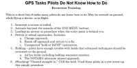


Several of these have more than one method and I don't care which someone chooses to use so long as it works (my "First Commandment" of instruction is not to change a pilot technique that works just because I like another better). But if I suspect a technique, I'll throw in a twist to see if it actually does work. I'll give an example of that.Nice list. For number 6 using my GTN 650xi, when the hold is at the PT and you're finally cleared in, I found that a simple "Activate Vectors to Final" clears the hold and lets you continue. I did this with my CFII a few years back, as she was a bit kerfuffled on why things weren't working. For a hold outside of the IF, I just "Activate" the full approach. I then "direct to" the fix ATC wants me to go to, or of course follow any vectors given. If vectored then to intercept and not fly to the IF, then easy enough to convert to "Activate Vectors to Final".
Mebbe I'm confused, but wasn't there a NOTAM that the PAPIs were inop? If that was the case, shouldn't that have affected the decison to try this approach in the first place?Asked and answered. You can have “the runway” in sight but not the approach end
It's among the considerations, but not necessarily. @Flying Keys is correct that one might have only part of a runway in sight. But the way this works visually is that if the part of the runway you want to land on is continuously in sight, you will miss the terrain. In this situation, if you keep the approach threshold in sight (you can actually see the numbers), you will clear the terrain for a "normal" landing. This is not even close to the Steamboat situation, but in this photo, you can see the approach end of the runway. So long as that remains visible as the target, the airplane will land on the approach end of the runway and will not hit that "ridge" between the trees.Mebbe I'm confused, but wasn't there a NOTAM that the PAPIs were inop? If that was the case, shouldn't that have affected the decison to try this approach in the first place?
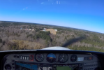
Yes, but a couple things:Mebbe I'm confused, but wasn't there a NOTAM that the PAPIs were inop? If that was the case, shouldn't that have affected the decison to try this approach in the first place?
I believe that the approach was originally designed to provide a Category C option. That limited the VDA to 3.77. It also would have put obstacles in the Cat C circling area so the Circling NA at night note is explained. Then it appears the approach was modified to remove Cat C. Cat B uses a smaller circling area, so the note probably could have been removed as evidenced by the RNAV -E. The GP could have been increased to be up to 4.2 degrees, but wasn't. The PAPI is set to 4 degrees and has baffles that block viewing to the left more than 5.5 degrees of CL. The angle to the runway is a little over 17 degrees. As designed, the pilot probably started down prior to WDCHK and would have busted the MDA at WDCHK. The distance to the runway is about 6.3 SM at WDCHK and the reported visibility was 5 SM, making it less likely he had the runway in sight prior to descending below the MDA, day or night. Since it was night, descending below the MDA was illegal. It appears that the approach is NA by NOTAM and is either going to be redesigned or cancelled. It would work for Cat B if the VDA was increased to 4.2 degrees.If I'm recalling correctly, I think you mathed it as just under 4°, which is below the TERPS category B maximum straight-in glide path angle of 4.2°
What regulation says you can't use +V below MDA?

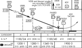
Not at all unusual for civilian approaches either.Perhaps slap an intermediate step down fix on top of the mountain and call it a day? It's not unheard of [stepdown fixes inside the FAF]; they're somewhat common in my .mil training circle.
LNAV equipment may provide advisory vertical guidance. Advisory vertical
guidance is defined as supplemental guidance where the barometric altimeter
remains the pilots primary altitude reference. This advisory guidance should use
the vertical path and deviations defined in Section 2.2.4. This advisory guidance
may be provided even when SBAS corrections or integrity information is not
available. This advisory guidance cannot be used to descend below the LNAV
MDA or step-down altitudes.
I’ve noticed similar NOTAMs go into effect following other accidents, particularly the one at MYF last year. Is it routine for them to NOTAM visual or electronic guidance u/s following an accident? Perhaps for inspection?These were the NOTAMs from the FAA archive search in effect at KSBS on 2-13-2026. The accident was a little after 0700Z, midnight local time. The PAPI and runway end light NOTAMs were effective about four hours later, at 1111Z and 1112Z, so were not in effect at the time of the accident.
Archived NOTAMs for Archival search on location 'KSBS' and date '2026-02-13'
Filter(s) used: None
Query ran at UTC: 26 Feb 2026 1452 UTC
!SBS 02/004 SBS RWY 32 PAPI U/S 2602131111-2602142300EST
!SBS 02/005 SBS RWY 32 RWY END ID LGT U/S 2602131112-2602142300EST
-----End of PDF Report.-----
@RussR , do they typically flight check facilities after an accident like this?I’ve noticed similar NOTAMs go into effect following other accidents, particularly the one at MYF last year. Is it routine for them to NOTAM visual or electronic guidance u/s following an accident? Perhaps for inspection?


