Ed Haywood
Final Approach
Colorado Epic E1000 Crash Near Steamboat Springs Kills Four
A single-engine turboprop impacted Emerald Mountain while on approach to Steamboat Springs airport in Colorado in CFIT accident.


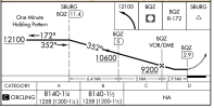
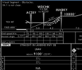
Oof, yeah. I also wonder if they were on a +V. "Visual Segment - Obstacles" in the profile view is telling.If whatever approach/ap vertical guidance selected doesn’t level off at the MDA, it would take it right into the mountain, which juts into the nominal glidepath.
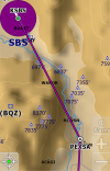
Are you sure it wasn’t the RNAV-E? That’s the only approach at SBS that’s approved at night. Either way, it appears they descended through the MDA. Time will tell as to why that happened. This stuff can kill you if not executed properly.This wasn’t the VOR approach, it was the RNAV Z Rwy 32. ADS-B shows approach mode was active, but it’s an LNAV approach, annd it’s unclear whether they were following any vertical advisory guidance. Nonetheless, the MDA is 9100’ all the way out from WDCHK, which is 5nm from the MAP and just over 2 prior to the mountain. If whatever approach/ap vertical guidance selected doesn’t level off at the MDA, it would take it right into the mountain, which juts into the nominal glidepath.
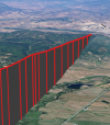
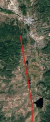
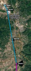
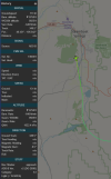
From the 3D path, as seen below, it looks like it just kept descending on a fairly steady glidepath.
View attachment 149925
(I highlighted the runway for contrast)
Weather:
METAR KSBS 130715Z AUTO 00000KT 10SM SCT005 BKN016 OVC024 A3016 RMK AO1
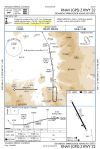
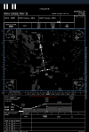
Note also the chart notes, which specify straight-in minimums to rwy 32 and circling to runway 32 is NA at night. This was just after midnight local.
View attachment 149926

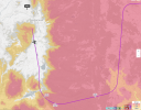
Pretty sure. The flown course lines up exactly with the RNAV-Z 32. The RNAV-E actually aligns with the runway, but that course is east of where they were.Are you sure it wasn’t the RNAV-E? That’s the only approach at SBS that’s approved at night. Either way, it appears they descended through the MDA. Time will tell as to why that happened. This stuff can kill you if not executed properly.
Sad.
The BQZ VOR is about a mile west of where they impacted, on the same east-west ridge. They weren’t on a course that aligns with the VOR approach, either. I’m pretty sure they were on the RNAV-Z Rwy 32 - see my last.Looks like he hit the back side of Emerald mtn where Howelson ski area faces east. The Robert VOR is very close to the ski area. The FA path was supposed to be down the Yampa river valley, as noted just to the east. No idea what(if any) appr was being used, but it appears he went right at the VOR.
Okay, yeah, fair enough. Quite odd they’d have chosen that approach.Pretty sure. The flown course lines up exactly with the RNAV-Z 32. The RNAV-E actually aligns with the runway, but that course is east of where they were.
I know the chart notes the “visual segment-obstacles,” but this seems to be an edge case. It may be absolutely legal to descend below MDA after WDCHK, given the conditions in 91.175 are met (which we don’t know in this case), however a CDFA from that waypoint will put you in the mountain. Any descent prior to the mountain will bring you awfully close to it.Okay, yeah, fair enough. Quite odd they’d have chosen that approach.
This. SBS isn't quite Telluride, but not my first choice to be making an arrival at that time of night in those conditions.Should have went to Hayden.

I am the Father of the pilot and Grandfather of two of the young men who perished on this flight. The fourth was a close family friend. I know some of you guys know more about aircraft and flight procedures then I will ever be aware of. I have flown with my son numerous times in his first plane (a Cirrus) and this one. Here is what I know about the plane and the pilot. He bought the Epic in 2024 after having flown the Cirrus for a couple of years. All service on the plane was done by Epic out in Oregon. He loved that plane and worked very hard to take care of it. When he got the plane he already had close to 1000 hours flying and he hired a qualified Epic pilot to fly with him for around a period of time flying 10 or 12 flights a week at least. The last time I spoke to him about it (maybe 3 months ago) he was approaching 5000 hours in the Epic. I remember telling him the first time we flew together how impressed I was with his seriousness at flying. When he was in that plane it was all business. I'm sure the NTSB will come up with an answer but we may have to wait awhile. He was a good man with a devoted wife and four children (now just three). He would fly all over the country picking up family members to help them out for funerals, weddings, etc... He owned and operated multiple businesses and employed close to 200 people. He had the attitude that God had blessed him with the money he earned and therefore he should help take care of others which he did. I know of at least three houses he built or bought for people plus multiple vehicles. If it turns out to be pilot error it will be tragic but it doesn't change who the man was. He was only 47 but he accomplished more than most people could in a 100 years. My heart is broken.
Yeah, I see it too. "Sel. Alt: 13600" and "Nav Mode: Approach", if accurate, are two clues.Someone in another forum observed that the ADSB data showed that the pilot dialed in the missed approach altitude (13.6k) into the pre-select after passing MABKY.
To me, this indicates that the AP was set to fly the “advisory” glidepath starting at MABKY, which must have led directly into the mountain. Either he wasn’t visual at minimums, or he was visual but couldn’t see the mountain given the darkness.
I suppose we can take this as a warning about the “advisory” glide path.

Not trashing the dead or the father who's lost his son, but there is absolutely no way he had 5000 hours in an aircraft that he bought less than 24 months ago.
Could be he added a zero. 500 is plausible. Dad is not in condition to proofread. BTDT.
That would make more sense.Could be he added a zero. 500 is plausible. Dad is not in condition to proofread. BTDT.
To me, this indicates that the AP was set to fly the “advisory” glidepath starting at MABKY, which must have led directly into the mountain. Either he wasn’t visual at minimums, or he was visual but couldn’t see the mountain given the darkness.
I suppose we can take this as a warning about the “advisory” glide path.
Garmin avionics (as the Epic has) will give you a “+V” advisory glide path on LNAV or other approaches that lack vertical guidance. It warns you to not rely on the +V without visual contact, presumably for things like mountain peaks that intrude upon said glide path.I’m not familiar with the avionics in the Epic. What makes you believe the AP was set to fly that advisory path? Is that some sort of default?
Could he have also selected VS or PITCH or some other vertical mode and been “diving and driving”? Or, is there a default 3.0 degree glide path that can inadvertently get into the mix during the visual portion of the approach?
It is advisory, meaning nice to have. You just don't follow it below any fix altitude and you are good.So my instructor keeps checking if I am using the advisory “glide slope”. And I have it do the altitude check on written on the table right on the plate.
The plates I have seen online don’t have the altitude table for the glide slope. How does someone check if they are below the slope?
Yeah, that’s the “regs and knowledge” part of my last comment.I don’t get it, artifical glide path or not he descended below MDA without airport environment in sight
Yes I know don’t follow the advisory.It is advisory, meaning nice to have. You just don't follow it below any fix altitude and you are good.