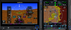
I ran this a few more times in the trainers, this time using a GDU1060 with the GTN, which looks and behaves a little more like a G1000Nxi. Again, the red terrain in the "MFD" view didn't show up until about 7 seconds, or ~1700 horizontal feet (0.28nm) prior to impact at the 145 kts groundspeed flown in the accident sequence. The GTN and "MFD" had to be zoomed into about 2nm or less to really notice it. On auto zoom, it was zoomed back out to (correction

3nm, which really doesn't resolve the red terrain well amongst everything else on the map.
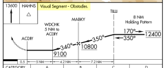
Again, no TAWS warning in the trainer. I tried to get TAWS to activate just descending through the same waypoints, but in ENR mode (no approach selected) and couldn't get it to do so on the same glidepath, though I still hit the terrain. I was only able to get TAWS to activate by being a few hundred feet low with no approach loaded.
Take these results with a major grain of salt - using a G1000 and who knows how everything was configured on the accident aircraft could be incredibly different. There's no other way to really see how this would have looked without either spending money to fly it and risking a collision, or getting an official simulation run using any known information from the accident aircraft.
But the results of these experiments show how the collision might not necessarily be obvious by instruments alone.
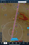
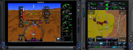
Here's what the first indications of the red terrain looked like, albeit slightly
above glidepath (and at a lower speed - I did it slowly to make sure I captured it in a screenshot), GTN zoomed into 1 mile:
(Edit) this is what it looked like, everything at full speed - "MFD" on the GDU manually zoomed to 1nm, and the GTN on auto zoom at 3nm:
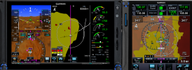
With only 7 seconds until a notional impact, this is really hard to see and make any useful reaction.