VFR Cruise Altitudes Question

LowHrsMan

Pre-Flight
Joined
Jun 6, 2021
Messages
69
Location
Washington
Display Name
LowHrsMan
Home Airfield
KVUO
When flying northbound over various waypoints (and to avoid TFRs and the KSEA Bravo), my magnetic heading varies from 357 - 03 at intervals of 10-25 NM.
Am I really required to change altitudes between even/odd + 500 feet each time my heading crosses 359 degrees?
Is that how y'all would fly it? If not what do you do for routings like that?
Seems like a lot of needless climbing and descending to comply with 91.159.
 
My rule of thumb was 10 degrees either side of the NS line was good enough. With wind drift and magnetic compass errors, the actual tracks have a lot of variation.
 
When flying northbound over various waypoints (and to avoid TFRs and the KSEA Bravo), my magnetic heading varies from 357 - 03 at intervals of 10-25 NM.
Am I really required to change altitudes between even/odd + 500 feet each time my heading crosses 359 degrees?
Is that how y'all would fly it? If not what do you do for routings like that?
Seems like a lot of needless climbing and descending to comply with 91.159.
91.159 bases it on your magnetic course, not your heading, so I would think that changes in heading for the purpose of maintaining a specific course would not require altitude changes. Also bear in mind that the rule only applies when you're more than 3000 feet above the surface.
 
When flying northbound over various waypoints (and to avoid TFRs and the KSEA Bravo), my magnetic heading varies from 357 - 03 at intervals of 10-25 NM.
Am I really required to change altitudes between even/odd + 500 feet each time my heading crosses 359 degrees?
Is that how y'all would fly it? If not what do you do for routings like that?
Seems like a lot of needless climbing and descending to comply with 91.159.

First, make sure you understand the difference between heading and course. Looks to me like you are using them interchangeably.

Screenshot_20250919-122054.png

I would pick less intermediate waypoints. Do you really need a waypoint every 10-25nm when the overall direction of flight is the same?

If you do, perhaps because you are doing manual nav for PPL, then pick waypoints that are all on the same side of the divide.
 
Last edited:
When flying northbound over various waypoints (and to avoid TFRs and the KSEA Bravo), my magnetic heading varies from 357 - 03 at intervals of 10-25 NM.
Am I really required to change altitudes between even/odd + 500 feet each time my heading crosses 359 degrees?
Is that how y'all would fly it? If not what do you do for routings like that?
Seems like a lot of needless climbing and descending to comply with 91.159.
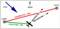
Let's look at two things.

1. As @Palmpilot points out, the hemispheric rule is based on magnetic course, not heading. If the course from point A to Point B is 051°, but there's a big wind from the west so your wind correction means your DG says 350, your are still eastbound for the purpose of the rule.

2. Always keep in mind that the rule isn't something that was created just to confuse us. It's so we don't crash into each other. And therein lies the problem - when we get to those courses that are due north or due south ± maybe 10-20 degrees, we are talking about potential danger to watch out for.
 
Last edited:
I try to pick my waypoints so that there is no ambiguity.

If close to due N/S is unavoidable, pick an altitude and stick with it; better to be consistent and predictable to ATC and those on ADS-B rather than have your altitude be all over the place.

Remember that, even if you are doing it right, someone else may be doing it wrong. I find myself slowing down at intersections even if I don't have a stop sign, because it is unwise to assume that the delivery driver on a "49cc" mad max scooter coming the other way will obey *his* stop sign...
 
When flying northbound over various waypoints (and to avoid TFRs and the KSEA Bravo), my magnetic heading varies from 357 - 03 at intervals of 10-25 NM.
Am I really required to change altitudes between even/odd + 500 feet each time my heading crosses 359 degrees?
Is that how y'all would fly it? If not what do you do for routings like that?
Seems like a lot of needless climbing and descending to comply with 91.159.
First off, it's not heading, it's COURSE.
If you're less than 3000 AGL, the restrictions don't apply.
If you're turning they don't apply.
 
The OP changes course to avoid restrictive airspace.
 
First, make sure you understand the difference between heading and course. Looks to me like you are using them interchangeably.

View attachment 145275

I would pick less intermediate waypoints. Do you really need a waypoint every 10-25nm when the overall direction of flight is the same?

If you do, perhaps because you are doing manual nav for PPL, then pick waypoints that are all on the same side of the divide.
I don't think I've ever seen this diagram before. Thx for posting.
 
When flying northbound over various waypoints (and to avoid TFRs and the KSEA Bravo), my magnetic heading varies from 357 - 03 at intervals of 10-25 NM.
Am I really required to change altitudes between even/odd + 500 feet each time my heading crosses 359 degrees?
Is that how y'all would fly it? If not what do you do for routings like that?
Seems like a lot of needless climbing and descending to comply with 91.159.
You’ve already been reminded that it’s course, not heading. Pick a course that does have a lot of dog legs that cross the north/south line. You are way more vulnerable when climbing and descending.
 
You’ve already been reminded that it’s course, not heading. Pick a course that does have a lot of dog legs that cross the north/south line. You are way more vulnerable when climbing and descending.
I think it doesn’t matter if there are dog legs. Ignore any midway points and fly the same altitude the entire flight based on the course from departure to arrival.
 
Last edited:
I think it doesn’t matter if there are dog legs. Ignore any midway points and fly the same altitude the entire flight based on the course from destination to arrival.
It sounds like he maybe might need to do one to avoid a TFR. But yeah, just about any flight you should be able to get by with only one and could probably be timed when your ready to begin descent to landing.
 
It sounds like he maybe might need to do one to avoid a TFR. But yeah, just about any flight you should be able to get by with only one and could probably be timed when your ready to begin descent to landing.
I think you’re missing my point. Dogleg as much as you want. Fly the altitude for the course from departure to destination airports.
 
I think you’re missing my point. Dogleg as much as you want. Fly the altitude for the course from departure to destination airports.

I question this interpretation. I could be wrong, but it does not seem consistent with the intent of the regulation.

Changing from 359 to 01, yeah ok, nobody from the FAA is on your shoulder. But applying that view to larger swings, say 340 to 20, IMO evades the clear intent of the regulation, which is to reduce the overall frequency of H2H convergence.

I'm curious how many others in this discussion ascribe to that interpretation?
 
Last edited:
I question this interpretation. I could be wrong, but it does not seem consistent with the intent of the regulation.

Changing from 359 to 01, yeah ok, nobody from the FAA is on your shoulder. But applying that view to larger swings, say 340 to 20, IMO evades the clear intent of the regulation, which is to reduce the overall frequency of H2H convergence.

I'm curious how many others in this discussion ascribe to that interpretation?
No, it's not based on the magenta line from departure to destination. But I think there's "dogleg" and then there's "DOGLEG."

Minor deviation for airspace, weather, whatever, where you return to the base course in a few minutes? Basically too much bother to go up and down 1,000 feet for a 2-3 minute change of direction. Arguably, you are maneuvering, not "cruising."

But when I think "dogleg," I'm thinking of something more like a direct route would be southeast, but you cruise southwest for 30 nm to avoid a Bravo or a large restricted area or high terrain before turning southeast to the destination.
 
In Canada so you know if you come up, it’s magnetic track in southern domestic airspace and true track in northern. Above 3000 agl.

Do you change when you flip between? Should. I don’t think people do it entirely correctly. If you aren’t sure just fly 3000 agl or below and yep continuously on 126.7 like the typical student pilot
 
I question this interpretation. I could be wrong, but it does not seem consistent with the intent of the regulation.

Changing from 359 to 01, yeah ok, nobody from the FAA is on your shoulder. But applying that view to larger swings, say 340 to 20, IMO evades the clear intent of the regulation, which is to reduce the overall frequency of H2H convergence.

I'm curious how many others in this discussion ascribe to that interpretation?
I don’t feel strongly either way frankly. None of this topic worries me much.
 
Throw in the Florida version of the hemisphere rule :), at least for IFR. N/S vs E/W. No idea if applies to VFR as it's not written anywhere I can find.
 
I think you’re missing my point. Dogleg as much as you want. Fly the altitude for the course from departure to destination airports.

I question this interpretation. I could be wrong, but it does not seem consistent with the intent of the regulation.

Changing from 359 to 01, yeah ok, nobody from the FAA is on your shoulder. But applying that view to larger swings, say 340 to 20, IMO evades the clear intent of the regulation, which is to reduce the overall frequency of H2H convergence.

I'm curious how many others in this discussion ascribe to that interpretation?
Another reason for questioning it is that when the hemispheric rule was written, RNAV capability had not yet become so widely available, so VFR flights were more likely to be along airways. In that circumstance, VFR courses that were nearly head-to-head at the same altitude were less likely to occur.
 
Another reason for questioning it is that when the hemispheric rule was written, RNAV capability had not yet become so widely available, so VFR flights were more likely to be along airways. In that circumstance, VFR courses that were nearly head-to-head at the same altitude were less likely to occur.
Interesting. I thought the hemispheric rule predated VOR navigation. I have seen references to it as early as 1938, although I'm not sure it applied to VFR flights at that point. I also recall before RNAV, I saw advisories about avoiding N-S airways and direct VOR navigation because of the increased risk of north vs head-on south collisions. People used to discuss offsets.
 
Another reason for questioning it is that when the hemispheric rule was written, RNAV capability had not yet become so widely available, so VFR flights were more likely to be along airways. In that circumstance, VFR courses that were nearly head-to-head at the same altitude were less likely to occur.

IMO on airways, exact compliance would be necessary, with no fudge factor. 359 you are even, 00 you are odd. But who flies those VFR anymore?
 
Throw in the Florida version of the hemisphere rule :), at least for IFR. N/S vs E/W. No idea if applies to VFR as it's not written anywhere I can find.
I’ve never seen some ad hoc thing written for Florida. And for all intents and purposes there is nothing different for for IFR in Florida either. In Controlled Airspace you fly the altitude you are assigned. In Uncontrolled Airspace the Hemispheric rule applies and there is nothing different in Florida. But there is so little navigable Uncontrolled airspace left in the Lower 48 it’s a moot point.
 
Many times I've filed IFR with a proper hemisphere based altitude and been given an incorrect one in my clearance. And several of those times I've had controllers further north ask if there was a reason I'm flying at the wrong altitude.....
 
Jacksonville Center and Miami Center have an MOU (Memorandum of Understanding) that govern IFR altitude selection transiting Florida. Flying southbound from the north it’s not unusual for Jax Center to change the altitude to accommodate Florida traffic, nor is it uncommon for ATC in Florida to change a requested altitude when issuing a clearance.
 
Many times I've filed IFR with a proper hemisphere based altitude and been given an incorrect one in my clearance. And several of those times I've had controllers further north ask if there was a reason I'm flying at the wrong altitude.....
That’s strange. That’s a question they would ask the Controller they took the handoff from. What do you say when they ask you?
 
Last edited:
Jacksonville Center and Miami Center have an MOU (Memorandum of Understanding) that govern IFR altitude selection transiting Florida. Flying southbound from the north it’s not unusual for Jax Center to change the altitude to accommodate Florida traffic, nor is it uncommon for ATC in Florida to change a requested altitude when issuing a clearance.
Yup. There are other places where the Hemispheric Rule altitudes are not strictly complied with, and are covered in Letters of Agreement. But not on a wholesale basis like in Florida.
 
Use flight following. They will remind you if they want a different altitude.
 
Throw in the Florida version of the hemisphere rule :), at least for IFR. N/S vs E/W. No idea if applies to VFR as it's not written anywhere I can find.
The Florida thing is IFR, where the hemispheric rule does not apply to pilots (except in Class G). We fly what ATC tells us to. The ATC manual follows the rule except where they change it for traffic management.
 
Last edited:
I’ve never seen some ad hoc thing written for Florida. And for all intents and purposes there is nothing different for for IFR in Florida either. In Controlled Airspace you fly the altitude you are assigned. In Uncontrolled Airspace the Hemispheric rule applies and there is nothing different in Florida. But there is so little navigable Uncontrolled airspace left in the Lower 48 it’s a moot point.
That's it exactly. Under IFR, there is no hemispheric rule in controlled airspace with which pilot's have to comply. We fly our assigned altitude.

Under VFR, the rule is very simple. I don't understand why there's any debate about whether or not it should be followed.

Many times I've filed IFR with a proper hemisphere based altitude and been given an incorrect one in my clearance. And several of those times I've had controllers further north ask if there was a reason I'm flying at the wrong altitude.....
There are no improper altitudes for IFR in controlled airspace. If a controller asks you why you're flying a particular altitude, tell them it is because that it is the altitude that the previous controller assigned.
 
I get the altitude assigned point, but I file IFR following the east odd convention to go out of FL. JAX always asks to move me up or down. Then the next controller moves back. Everywhere else I’ve flown it’s always east odd.
 
Many times I've filed IFR with a proper hemisphere based altitude and been given an incorrect one in my clearance. And several of those times I've had controllers further north ask if there was a reason I'm flying at the wrong altitude.....
No such thing as a proper hemispheric altitude rule for IFR in controlled airspace in the regulations, however in most, but not all parts of the CONUS, ATC follows the convention. The rule for IFR is simple:

§ 91.179 IFR cruising altitude or flight level.
Unless otherwise authorized by ATC, the following rules apply—
(a) In controlled airspace. Each person operating an aircraft under IFR in level cruising flight in controlled airspace shall maintain the altitude or flight level assigned that aircraft by ATC.

Florida is one airspace where the hemispheric rule is not followed for IFR.
 
I get the altitude assigned point, but I file IFR following the east odd convention to go out of FL. JAX always asks to move me up or down. Then the next controller moves back. Everywhere else I’ve flown it’s always east odd.
Hemispheric cruising rule for IFR only applies in uncontrolled airspace, which there is precious little of at cruising altitudes.
 
Back
Top