VFR Cruise Altitudes Question

Interesting. I thought the hemispheric rule predated VOR navigation. I have seen references to it as early as 1938, although I'm not sure it applied to VFR flights at that point. I also recall before RNAV, I saw advisories about avoiding N-S airways and direct VOR navigation because of the increased risk of north vs head-on south collisions. People used to discuss offsets.
Maybe there were airways that were defined by A-N ranges? Dunno.
 
I get the altitude assigned point, but I file IFR following the east odd convention to go out of FL. JAX always asks to move me up or down. Then the next controller moves back. Everywhere else I’ve flown it’s always east odd.
ATC, per 7110.65, uses the hemispheric rule most of the time. Florida is one place that they don't. That's ATC's problem, not yours. File what you want, fly what they give you.

The pattern that ATC uses in Florida is rather predictable so you can always plan that, if you know it. If you don't, you'll be 1,000' off of your plan, at least for a little while.
 
Interesting. I thought the hemispheric rule predated VOR navigation. I have seen references to it as early as 1938, although I'm not sure it applied to VFR flights at that point. I also recall before RNAV, I saw advisories about avoiding N-S airways and direct VOR navigation because of the increased risk of north vs head-on south collisions. People used to discuss offsets.
I found this…
The semicircular or hemispheric rule was formally established by the International Civil Aviation Organization (ICAO) for VFR (Visual Flight Rules) flights in
1946, though the specific enforcement and exact rule details have been codified and adapted by various countries and organizations since then. The rule mandates odd or even altitude choices based on eastbound or westbound magnetic track, respectively, to prevent mid-air conflicts.
 
And several of those times I've had controllers further north ask if there was a reason I'm flying at the wrong altitude.....
And your immediate response should be "Good question, if you can find out from XXX why they assigned it, I'd be curious to know the answer." :cool:
 
I have seen references to it as early as 1938, although I'm not sure it applied to VFR flights at that point.
And chance you can find the reference again?

I believe 91.159 was first brought up in 1989 to actually make the odd/even + 500 a regulation. But I'm pretty sure the practice or "rule" was around in the 70s.
 
And chance you can find the reference again?

I believe 91.159 was first brought up in 1989 to actually make the odd/even + 500 a regulation. But I'm pretty sure the practice or "rule" was around in the 70s.
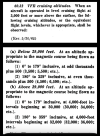
VFR rule as early as the 1963 CAR Part 60. It’s §60.32. I’ve seen mention of the rule for IFR as early as 1938. I don’t have anything in between 1943 and 1963, so I don’t know when 60.32 was first added.
(BTW, “Rev.” refers to the volume or page revision, not a reg revision)

1758505787526.png
 
Last edited:
VFR rule as early as the 1963 CAR Part 60. It’s §60.32. I’ve seen mention of the rule for IFR as early as 1938. I don’t have anything in between 1943 and 1963 p, so I don’t know when 60.32 was first added.
(BTW, “Rev.” refers to the volume or page revision, not a reg revision)

View attachment 145366
That's what I remember learning in 1971, the old NEOD/SWEVEN mnemonic
 
It's probably better to say the hemispheric rule for IFR is for planning and filing.
In most areas of the country, they do assign altitudes based on it, but you can request WADOF. There are some places where it's less practical (like Florida) and ATC there uses N/S as the directionality rather than E/W.

1. File what you want.
2. Fly what you get.
3. Log what you need.
 
In most areas of the country, they do assign altitudes based on it, but you can request WADOF. There are some places where it's less practical (like Florida) and ATC there uses N/S as the directionality rather than E/W.

1. File what you want.
2. Fly what you get.
3. Log what you need.
WADOF ??
 
VFR rule as early as the 1963 CAR Part 60. It’s §60.32. I’ve seen mention of the rule for IFR as early as 1938. I don’t have anything in between 1943 and 1963, so I don’t know when 60.32 was first added.
(BTW, “Rev.” refers to the volume or page revision, not a reg revision)

View attachment 145366
Interesting, VFR above 18,000. Do you know when the Positive Control Area was first established?
 
Interesting, VFR above 18,000. Do you know when the Positive Control Area was first established?
I don't. But the existence of a rule for it doesn't necessarily mean the conditions exist.. Take the modern IFR hemispheric rule for example. It applies in uncontrolled airspace. That's pretty limited. Maybe the Alaskan wilderness?
​
 
Last edited:
Interesting, VFR above 18,000.
You're thinking CONUS. Hawaii has no Class A airspace. Gliders and LTA aircraft can also get waivers for VFR flight above 18,000'

It applies in uncontrolled airspace. That's pretty limited. Maybe the Alaskan wilderness?
Outside of the CONUS, IFR is uncontrolled airspace is not that uncommon. I've flown into an airport where the floor of controlled airspace was FL245.

Remember that PCA/Class A only goes to 60,000 ft. Above that it’s uncontrolled again.
Above Class A, it reverts back to Class E which is controlled.
 
I've always found it funny, I could be flying course 179 while you are flying course 001 at the same altitude and collide, but thank goodness it wasn't head on!

That being said, Big Sky Theory does seem to work well. Most if not all mid-airs have occurred within just a few miles of an airport, usually within the traffic pattern itself. Many at airports with towers versus "pilot-controlled".

I will say, I am happy to use Flight Following or be on an IFR flight plan, and am grateful for ADS-B traffic data, although I never rely on either.
 
You're thinking CONUS. Hawaii has no Class A airspace. Gliders and LTA aircraft can also get waivers for VFR flight above 18,000'


Outside of the CONUS, IFR is uncontrolled airspace is not that uncommon. I've flown into an airport where the floor of controlled airspace was FL245.


Above Class A, it reverts back to Class E which is controlled.
Yeah, I know all that stuff. I was wondering the ‘when.’ When was Positive Controlled Airspace first created. I’m thinking maybe 1956 when the FAA was created. Or maybe 1938 when the CAA was created. Ain’t no big deal, I’m just curious.
 
I think you’re missing my point. Dogleg as much as you want. Fly the altitude for the course from departure to destination airports.
I don't think this works. The PCG defines "course" as, "The intended direction of flight in the horizontal plane measured in degrees from north." The intended direction of flight, not the bearing from your departure to your destination. Which makes sense because mid-air collisions don't happen based on your departure and destination points.
 
Outside of the CONUS, IFR is uncontrolled airspace is not that uncommon. I've flown into an airport where the floor of controlled airspace was FL245.
I know. Canada has large areas of uncontrolled airspace where IFR operations are performed.

That's why I limited what I'm saying to US airspace.

Hawaii has no Class A airspace.
Actually it does. The regs were amended in 2019 to add the Hawaiian High and Hawaiian Low Offshore Airspace Areas. The High is Class A at the US-standard 18,000 - 60,000'. But, continuing with the theme, at the opposite end, other countries have Class A beginning at 6,000 (and probably lower).
 
Yep. It’s what we are going to get by far most of the time (Florida’s experience aside), so we might as well plan and file it.
Agree, but I have deliberately filed "wrong way" IFR altitudes, particularly to stay at a lower altitude and remain below the freezing level. I have always been assigned what I filed, I can't recall when I wasn't.
 
Do you know when the Positive Control Area was first established?
Late 50s or early 60s. And intially I think it was just in certain areas. Then a few year later they made the blanket Positive Control Area over the entire US.

No clue about other countries, so don't know if you had a leg that flew over Canada if you could have seen VFR traffic out the window. But then I guess Canada usually matched the US.
 
I was wondering the ‘when.’ When was Positive Controlled Airspace first created. I’m thinking maybe 1956 when the FAA was created.
Looks like 1954. A number of subsequent high-profile collisions led to strengthening of the airspace, equipment, and ATC requirements including the collisions of DC-7 and Lockheed Constellation over the Grand Canyon in 1956, the collision of a DC8 and Lockheed Electra over New York in 1960, the collision of a B-727 and C-172 over San Diego in 1978, and the collision of a DC9 and PA-28 over Los Angeles in 1986.
 
Agree, but I have deliberately filed "wrong way" IFR altitudes, particularly to stay at a lower altitude and remain below the freezing level. I have always been assigned what I filed, I can't recall when I wasn't.
The good news is that at the lower altitudes light GA flies, there isn't a heck of a lot of traffic on an IFR day, so we're usually not in conflict with anyone. I've been surprised at how empty even the NE corridor can seem.
 
Looks like 1954. A number of subsequent high-profile collisions led to strengthening of the airspace, equipment, and ATC requirements including the collisions of DC-7 and Lockheed Constellation over the Grand Canyon in 1956, the collision of a DC8 and Lockheed Electra over New York in 1960, the collision of a B-727 and C-172 over San Diego in 1978, and the collision of a DC9 and PA-28 over Los Angeles in 1986.
I was thinking about the Grand Canyon accident. Just looked it up. It happened up around 21,000 it looks like. One of them went OTP, the other may have cancelled. I think it’s likely that’s around when the PCA was made and 18,000 seems like a likely choice for the altitude where it starts.
 
Last edited:
Mark, you answered this observation:

Hawaii has no Class A airspace.

Actually it does. The regs were amended in 2019 to add the Hawaiian High and Hawaiian Low Offshore Airspace Areas. The High is Class A at the US-standard 18,000 - 60,000'. But, continuing with the theme, at the opposite end, other countries have Class A beginning at 6,000 (and probably lower).

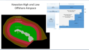
I think the airspace within 12 NM of the shore line of Hawaii and above 18000 MSL is class G airspace. The Hawaii Islands High airspace excludes the airspace over the Hawaiian Islands and out to 12 NM off shore. Is this your understanding?
 
Interesting, VFR above 18,000. Do you know when the Positive Control Area was first established
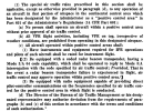
Hello! Turns out it's discussed in the same volume as I found the early VFR hemispheric rule. It's Special Civil Air Regulation SR-424C Effective August 30, 1960. A snip from it.
1758564637385.png
 
Mark, you answered this observation:

Hawaii has no Class A airspace.


I think the airspace within 12 NM of the shore line of Hawaii and above 18000 MSL is class G airspace. The Hawaii Islands High airspace excludes the airspace over the Hawaiian Islands and out to 12 NM off shore. Is this your understanding?
I've never tried to put together an airspace chart. I bet a Hawaiian flight school could tell us. OTOH, if someone is really adept at mapping...


Hawaiian Islands High [New]​

That airspace extending upward from 18,000 feet MSL to and including FL 600 within the area bounded by a line beginning at lat. 24°43′17″ N, long. 155°15′47″ W; to lat. 24°17′45″ N, long. 154°15′00″ W; to lat. 23°46′50″ N, long. 153°21′58″ W; to lat. 23°01′27″ N, long. 152°34′40″ W; to lat. 22°20′39″ N, long. 151°53′07″ W; to lat. 21°32′52″ N, long. 151°27′59″ W; to lat. 20°41′49″ N, long. 151°01′09″ W; to lat. 19°41′47″ N, long. 150°30′11″ W; to lat. 19°13′22″ N, long. 151°52′46″ W; to lat. 19°08′32″ N, long. 154°29′00″ W; to lat. 18°06′32″ N, long. 155°42′42″ W; to lat. 17°48′18″ N, long. 156°04′05″ W; to lat. 17°10′14″ N, long. 156°48′21″ W; to lat. 17°10′14″ N, long. 157°45′24″ W; to lat. 17°13′28″ N, long. 158°15′04″ W; to lat. 17°45′21″ N, long. 159°32′20″ W; to lat. 18°03′09″ N, long. 160°16′11″ W; to lat. 18°24′28″ N, long. 160°48′51″ W; to lat. 19°24′54″ N, long. 162°23′01″ W; to lat. 19°39′29″ N, long. 162°41′58″ W; to lat. 20°07′00″ N, long. 163°18′00″ W; to lat. 21°09′04″ N, long. 163°54′52″ W; to lat. 22°12′20″ N, long. 163°54′52″ W; to lat. 23°15′30″ N, long. 163°51′18″ W; to lat. 24°10′08″ N, long. 163°15′59″ W; to lat. 25°03′24″ N, long. 162°38′59″ W; to lat. 25°40′34″ N, long. 161°41′28″ W; to lat. 26°06′18″ N, long. 160°37′54″ W; to lat. 26°08′41″ N, long. 158°37′19″ W; thence to the point of beginning, excluding that airspace within 12 miles of the shoreline of the State of Hawaii.
 
Don't have to plot the outer boundaries of the Hawaiian Island High because it ends with "excluding that airspace within 12 miles of the shoreline of the State of Hawaii."

And, this is what 71.33 states:

71.33 Class A airspace areas.
(a) That airspace of the United States, including that airspace overlying the waters within 12 nautical miles of the coast of the 48 contiguous States, from 18,000 feet MSL to and including FL600 excluding the states of Alaska and Hawaii.

So over Hawaii, above class E, is class G. I guess they don't want contrails above the state.
 
Don't have to plot the outer boundaries of the Hawaiian Island High because it ends with "excluding that airspace within 12 miles of the shoreline of the State of Hawaii."

And, this is what 71.33 states:


So over Hawaii, above class E, is class G. I guess they don't want contrails above the state.
Wrong part of the reg. 71.33 (a) is the general definition of Class A, which excludes Hawaii. You need to look at 71.33(c)
"(c) The airspace areas listed as offshore airspace areas in subpart A of FAA Order JO 7400.11J (incorporated by reference, see § 71.1) that are designated in international airspace within areas of domestic radio navigational signal or ATC radar coverage, and within which domestic ATC procedures are applied." (my emphasis)

Definition of the Hawaiian Islands High Class A and its metes and bounds description appears in JO 7400.11 (now revision K) at page 10.

John, you know this, but for others, all airspace, IAPS, etc are created by regulation. We don't see them in the base FAR to avoid a couple thousand pages of clutter. Instead, they are published separately and incorporated by reference.

Edit:
flyinginhawaii.com has this map:
1758570143917.png
 
Last edited:
Wrong part of the reg. 71.33 (a) is the general definition of Class A, which excludes Hawaii. You need to look at 71.33(c)
"(c) The airspace areas listed as offshore airspace areas in subpart A of FAA Order JO 7400.11J (incorporated by reference, see § 71.1) that are designated in international airspace within areas of domestic radio navigational signal or ATC radar coverage, and within which domestic ATC procedures are applied." (my emphasis)

Definition of the Hawaiian Islands High Class A and its metes and bounds description appears in JO 7400.11 (now revision K) at page 10.

John, you know this, but for others, all airspace, IAPS, etc are created by regulation. We don't see them in the base FAR to avoid a couple thousand pages of clutter. Instead, they are published separately and incorporated by reference.
This is the reference provide to me by the FAA when I asked the question in 2021. 71.33(c) applies to international airspace. The airspace over Hawaii is part of the US, last I checked. :)
 
Back
Top