The safety of this circling approach

circling approach … and what's the min altitude?
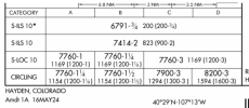
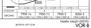
You’ll find that on IAP charts.
examples:
- ILS RWY 10
1773212957619.png
- VOR-B
1773213068789.png

Also to consider …
notes, such as circling not authorized at night, or circling not authorized (direction) typically when there’s terrain/obstacles, etc.
For example RNAV 26 DXR indicates rnav
(gps) 26 procedure is NA at night, and, circling south of 8-26 is NA, anytime (due to terrain and a tower).

1773214221150.jpeg
 
Last edited:
Not a fan of circling approaches,try not to use them except as a last resort.
 
Yes

600ft AGL. he was about 100ft higher.

Circling left put him over the people/museum grounds and other relatively populated areas, circling right would've been a bit more convoluted but kept him mostly over farmland.
If the airport is left traffic, if under IFR, the pilot is required to circle left traffic unless "circling NA" for left traffic.
 
Circling approaches in anything beyond Category A is almost never a good idea in real practice. That said, they have their purpose and we need to know and understand how to fly one.

I see nothing wrong here. The approach appears to be flown as designed.
 
Ill add this to the conversation. I have met pilots that have been taught it is dangerous to bank an airplane below 1,000 AGL. They see someone doing any maneuvering at low altitude, it "concerns" them.

I am not one of them...
 
This is why when a type is issued under 121 it typically carries the limitation "CIRC. APCH. - VMC ONLY"
I know this is silly, but I’ve always thought it’s a funny way to word that limitation, as all circling approaches are conducted in VMC.
 
all circling approaches are conducted in VMC.
If with 'VMC' you mean 'clear of clouds', then yes. But the more common use of 'VMC' is to describe weather conditions which meet or exceed the minimum visibility and cloud-distance requirements for operating under VFR. Which means there are absolutely situations where one can legally circle-to-land without being in VMC.

- Martin
IOW. as the regulatory definition tells tells us, "Visual meteorological conditions (VMC) means meteorological conditions expressed in terms of visibility, distance from clouds, and ceiling equal to or better than specified minima."

So, for Class E , D, and C surface areas, we're talking minimum 1,000' ceiling and 3 SM visibility. If the nontowered airport is Class G below 700 it gets tighter, since it's VMC clear of clouds with 1 SM visibility.
 
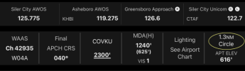
Small tangent. I just noticed for the first time that Garmin Pilot’s SmartCharts display the circling area and the protected radius. Any one, else using the app notice?
 
Although I (still) prefer FliteCharts to SmartCharts in GP, very cool tip. Thanks!
 
There are so many types & conditions with circling approaches is hard to paint with one broad brush. On the one hand you have the minimums, MDA and viz requirements. Some can be more of a ‘side step’.

I look at it like getting VMC under the layer, then maneuvering to land. Yes, may be restrictions on direction of circle, whatever. If the MDA is 800’, nothing wrong with staying at 1100’, weather allowing. I’m not talking about a check ride. One should account for winds during maneuvering, no reason to get ‘wrapped up’.

Like a VOR-A approach, gets you down then you maneuver to land. I’m reminded of the sometimes overused adage, don’t fly the plane where your mind hasn’t already been.
 
Also done with ForeFlight Dynamic Procedures when you select circling to land MDA.

John, do you know where FF gets the circling radii data? As far as I know it's not included in the ARINC 424-18 coding, and the only place I know to find it is on the Form 8260-9 PDF. Are they manually (or AI-ually) just pulling it from that PDF?
 
John, do you know where FF gets the circling radii data? As far as I know it's not included in the ARINC 424-18 coding, and the only place I know to find it is on the Form 8260-9 PDF. Are they manually (or AI-ually) just pulling it from that PDF?
For standard circling areas, I believe the radius is based on the table published in the TPP and the pilot selects the category being used. The altitude comes from the Circling MDA for that category. The runway layout comes from other data already available.
 
For standard circling areas, I believe the radius is based on the table published in the TPP and the pilot selects the category being used. The altitude comes from the Circling MDA for that category. The runway layout comes from other data already available.

Okay, that makes sense that they would use the approximation in that table for this purpose. I didn't know if they were getting the actual, calculated circling radius from the forms, or using the approximation in the TPP table, which admittedly should be close enough for "displaying on a chart" purposes.
 
Okay, that makes sense that they would use the approximation in that table for this purpose. I didn't know if they were getting the actual, calculated circling radius from the forms, or using the approximation in the TPP table, which admittedly should be close enough for "displaying on a chart" purposes.
I suspect the Garmin Pilot ones are being done the same way, although since it's intended as a chart replacement, I suspect Garmin is looking at the 8260s.

It's not only pictorial, the SmartChart "Details" and "Brief" tabs include the category radius. Confirming whether it's the table or the calculated radius should be simple. Do you know an approach where the calculated radius for a specific category is different? All we have to do is look.

1773593079545.png
 
Last edited:
I suspect the Garmin Pilot ones are being done the same way, although since it's intended as a chart replacement, I suspect Garmin is looking at the 8260s.

It's not only pictorial, the SmartChart "Details" and "Brief" tabs include the category radius. Confirming whether it's the table or the calculated radius should be simple. Do you know an approach where the calculated radius for a specific category is different? All we have to do is look.

View attachment 150823

Try 1S3 RNAV (GPS) RWY 27.

MDAs are all between 3300 and 3700, so by the table the radii should be Cat B 1.8, Cat C 2.9, Cat D 3.8. However, from the forms, the actual calculated Cat B radius is 1.90, Cat B is 3.00, and Cat D is 3.93.

(Cat A radius is almost always 1.3, or close enough to it that it rounds to 1.3 when you're only using one decimal place.)
 
Last edited:
Try 1S3 RNAV (GPS) RWY 27.

MDAs are all between 3300 and 3700, so by the table the radii should be Cat B 1.8, Cat C 2.9, Cat D 3.8. However, from the forms, the actual calculated Cat B radius is 1.90, Cat B is 3.00, and Cat D is 3.93.

(Cat A radius is almost always 1.3, or close enough to it that it rounds to 1.3 when you're only using one decimal place.)
Pilot is pulling it from the standard table, not the form. ForeFlight doesn’t tell you the numerical radius and I can’t really tell although using the ruler it looks like it’s greater than 1.8 for B.
 
Pilot is pulling it from the standard table, not the form. ForeFlight doesn’t tell you the numerical radius and I can’t really tell although using the ruler it looks like it’s greater than 1.8 for B.
I suspect (strongly) that the table is being conservative, i.e. for each 2000-ft range they are using the calculated radius for the low end of that range, with the idea being that if you think you have 1.8 nm to circle in, and you really have 1.9, that's safer than the reverse. Which makes sense to me. At least in an academic sense, because if you're that close to the edges of the circling area you may be very close to higher terrain - there is no buffer on circling areas beyond what's shown in the table (or calculations).

I seem to remember there was discussion years ago about how to chart the new circling areas (not just showing the "inverse C", which has now been phased out, but whether or not to show the actual radius). I'll look and see if I can find it.
 
Found it. Lots of discussion over the years 2009-2012 leading up to the implementation of the criteria change.


Including several proposed ways to indicate the information on the approach charts (ultimately the "inverse C" and table at the front of the TPP was decided on):

 
The table is all the guidance given to pilots. TERPS protects slightly wider radius, but this is extra protection. The pilot only needs to know the radius that is published in the TPP, not the TERPS value. ForeFlight and Garmin shows it graphically. Garmin also shows it numerically.
 
Not all circling approaches are routine. Some can bite.

Probably the closest I ever came to dying in a plane was a whole bunch of self-created cheese holes lining up to initiate a circling approach which almost ended very badly. And it was not the reported ceiling, visibility, or ground track flown that was the worst of it.

Nothing to be proud of, but lots learned that I still swear nine years later I shall never repeat.

 
Consider how, even at the Private Pilot level, selecting an “appropriate distance” is part of the ACS for ground reference maneuvers.
Yep. The one and only CTL I've done in anger (minimums) it appeared as if things were too fast and too close when I popped out.
 
Yep. The one and only CTL I've done in anger (minimums) it appeared as if things were too fast and too close when I popped out.
FWIW, I've done lots of circling approaches and IMO, the best place to start one is from right over the center of the airport. It kind of makes them pretty much all look the same.
 
The error most pilots make on a CTL is (1) failure to keep your speed up and (2) understimating the radius of the turn. The "Safe areas" denoted by the circles at the end of each authorized runway are BASED IN PHYSICS. And like most, it require practice AT THE ALTITUDES that one might have to use due to ceiling.

I've never encoutered, at IPC, a GA pilot who has practiced CTL...fight what you practice.
 
Yep. The one and only CTL I've done in anger (minimums) it appeared as if things were too fast and too close when I popped out.
That's one of the two big problems with CTL training. The view at half pattern altitude can be disconcerting, even in CAVU conditions unless practiced. There's often a tendency to be too close to the runway. Unfortunately, too many practice it at nontowered airports where other pattern traffic often means flying higher, so they never integrate that view even for the checkride.

The bigger problem with CTL training is that it's completely unrealistic you are pretending there's a 500' ceiling and only 1 mile visibility on a CAVU day.
 
Back
Top