Here’s some history.
https://www.faa.gov/sites/faa.gov/files/2022-07/Hist_22-01-368.pdf
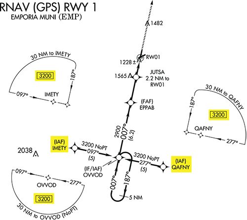
It makes sense to not sectorize conventional nav MSA’s centered on the airport. The airport has no radials to identify the sectors so one altitude makes sense. What doesn’t make sense to me is that RNAV MSA’s are not sectorized. What could easier to do than determine your direction from a Waypoint than using a GPS Navigator. As far as why can’t we use the TAA’s, feel free to do it. MSA’s are emergency altitudes. In an emergency you have the authority to make the decision.
I'm thinking in the opposite direction. Why have any sectorized?
At least part of the underlying assumption is that the emergency is a loss of navigational capability. If you only have a vague idea where you are, might as well just use your sectional chart or LIFR chart OROCAs.
These two posts kind of highlight the "plot hole" that is the MSA.
What is the MSA? I've always been taught and thought of it as "if you have an emergency, you can climb to to this altitude within this area and not safely fly around randomly while figuring out your problem and not hit anything." But even from the first look this is flawed. For example, I learned to fly instruments in planes without even DME. So how would I comply with the "within 25 nm" rule? My intention was always that since I was in a 172 or similar, if I just stayed somewhere near the VOR I'd certainly not stray too far.
But realistically, if I have enough NAV capability to determine that, I can probably fly an approach. Or I could at least enter a holding pattern to work out my gear issue or whatever it is. But of course, if I have Comm, I'll be asking ATC for help anyway, and they can direct me somewhere safe at a safe altitude.
The author of the PDF linked above (Garmin employee) also seems to be unclear on the purpose of the MSA. He writes several times about the MSA coverage not being sufficient to "get you to" the respective approach procedure. But that's not the intent of an MSA (of course, the "intent" is probably no longer really applicable anyway and could probably do to be changed).
Also, the whole reason that an RNAV MSA is based on the MAP is simple - that fix is already in your route if you have the approach loaded. If you fly the approach and do nothing once going missed, it stays in there, and the distance to it is readily displayed. What could be easier? If it was changed to the ARP, you'd have button-dialing to do during an otherwise busy time.
The non-RNAV based MSA issue is a tricky one, and yes, needs to be revised. The number of "omni-directional facilities" keeps shrinking, and so finding one close to an ILS is sometimes not even possible. But one of the basic tenets of TERPS is to try to provide for the least-equipped airplane, i.e. VOR-only. But that's becoming less and less realistic and less practical, and more restrictive as time goes on. Perhaps it's time to change that philosophy.
I'd be interested to know from the folks here - have you ever actually "used" an MSA for its intended purpose? Know anybody who has? How recently? I've been flying for over 30 years and have never once needed to use an MSA due to some emergency/partial navigational failure. Maybe I'm just lucky, but I imagine my experience is typical.
")