RNAV (no TAA) - Cleared for the approach. When to descend?

ArnoldPalmer

Pre-takeoff checklist
Joined
Dec 3, 2015
Messages
204
Display Name

Display name:
ArnoldPalmer
An airport/FBO conversation that I could use some clarification on.

Title says it all, pretty much.

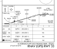
If one is at 4,000 feet - ATC says, "Cleared for RNAV 33 Approach. Cleared direct ATVEW maintain FOUR thousand until Established." When can one begin their descent? I thought that ATVEW is an IAF, so descend right after hitting that. Others say, nope. Maintain 4,000 till hitting BSHWD (and needles start centering) then descend to 3,100.

Thoughts?

Image did not paste: https://skyvector.com/airport/EQA/El-Dorado-Capt-Jack-Thomas-Memorial-Airport -- RNAV RWY 33 approach.


06607R33.svg
 
You're correct... as ATC instructed, maintain 4000 until ATVEW (an IAF)... at which point you ARE ESTABLISHED on the approach, so you then can descend as noted on the plate (3100' to BSHWD, 3000' to WAXFY, etc).

On the other hand, the instruction was likely "maintain -- at or above -- 4000'"... so you could stay at 4000' if you'd like until say BSHWD, then descend to WAXFY. Altitude is your friend. I'm guessing this is the source of the "discussion".
 
Last edited:
An airport/FBO conversation that I could use some clarification on.

Title says it all, pretty much.

If one is at 4,000 feet - ATC says, "Cleared for RNAV 33 Approach. Cleared direct ATVEW maintain FOUR thousand until Established." When can one begin their descent? I thought that ATVEW is an IAF, so descend right after hitting that. Others say, nope. Maintain 4,000 till hitting BSHWD (and needles start centering) then descend to 3,100.

Thoughts?

Image did not paste: https://skyvector.com/airport/EQA/El-Dorado-Capt-Jack-Thomas-Memorial-Airport -- RNAV RWY 33 approach.
You cannot descend below 4,000 before ATVEW. After crossing ATVEW you can descend to 3,100. After crossing BSHWD you can descend to 3,000.
 
It depends if you are established on a segment or not but that doesn’t mean the IAF, as there are two feeder routes before the IAFs that you could join depending on where you are. Plus, the MSA is 3600 unless on a segment.
 
It depends if you are established on a segment or not but that doesn’t mean the IAF, as there are two feeder routes before the IAFs that you could join depending on where you are. Plus, the MSA is 3600 unless on a segment.
The scenario presented by the OP was cleared direct ATVIEW, so was not on one of the feeder Routes, and MSA is irrelevant to the discussion.
 
Last edited:
The OP was cleared direct ATVIEW, so was not on one of the feeder Routes, and MSA is irrelevant to the discussion.

OP was not flying (thankfully). OP was on the ground overhearing a discussion at the airport.. :) And it involved an instrument student and the DPE.....
 
You have some poorly trained instrument pilots at your airport if they think you can't descend lower than 4000 until reaching BSHWD. The segment from ATVEW to BSHWD is clearly a published segment of the procedure, with an established and evaluated minimum altitude. OF COURSE you can descend to 3100 after ATVEW. Why wouldn't you be able to?

Now, in practice, I would probably stay at 4000 until intercepting the glidepath a few miles prior to WAXFY, but that's a technique, not a requirement.
 
Now, in practice, I would probably stay at 4000 until intercepting the glidepath a few miles prior to WAXFY, but that's a technique, not a requirement.

Russ, would not the needle be pegged down, if you were at 4000' at or after BSHWD?
 
Russ, would not the needle be pegged down, if you were at 4000' at or after BSHWD?
Dave,
I flew the approach from ATVEW maintaining 4000' until after the left turn at BSHWD. Below is the screen capture (X-Plane 12, KEQA RNAV33):
KEQA-RNAV33-jpg.jpg
Note that the Glidepath at 4.4 nm outside of WAXFY is still comfortably above our 4000'... i.e. life is good.
 
ATC says, "Cleared for RNAV 33 Approach. Cleared direct ATVEW maintain FOUR thousand until Established."
Maybe it's just me, but I think if the clearance were in PTAC format that it would probably be a little clearer what to do.
 
Russ, would not the needle be pegged down, if you were at 4000' at or after BSHWD?

A 3 degree glidepath is about 318 ft per NM, or about 3 NM per 1000 ft. So being 1000 ft above the published 3000 means you'll intercept glidepath about 3 NM prior to the FAF. Since the segment from BSHWD is 5 NM long, this should work fine as long as you're going at a reasonable speed and can finish the turn and get established on final reasonably promptly.
 
OP was not flying (thankfully). OP was on the ground overhearing a discussion at the airport.. :) And it involved an instrument student and the DPE.....
So the OP was reporting this after hearing this from someone who overheard something..??

Not enough fact for me.
 
Sloppy Phraseology. There is no authorized Approach Clearance Phraseology that simply says ‘until established.’ But Controllers often do it anyway. @ArnoldPalmer ,in the OP, said the Clearance he received was “…Cleared for RNAV 33 Approach. Cleared direct ATVEW maintain FOUR thousand until Established…” The point I’m making is until established on ‘what.’ It seems obvious that it was meant to be until established on a ‘segment of the Instrument Approach Procedure.’ The correct Phraseology would have been ‘maintain 4000 until ATVEW, cleared RNAV Rwy 33 Approach.’ After that, ya gotta comply with the numbers on the Chart. A good case has been made for hangin’ out at 4000 until the Glidepath ‘needle’ or diamond or whatever, starts moving. Someone said something about the MSA. It is simply not pertinent to this. Whoever that was, learn what MSA is. It’s googleable.
 
Russ, would not the needle be pegged down, if you were at 4000' at or after BSHWD?
At BSHWD, the Glidepath is about 4500. He did qualify his statement with “… should work fine as long as you're going at a reasonable speed and can finish the turn and get established on final reasonably promptly...”
 
A 3 degree glidepath is about 318 ft per NM, or about 3 NM per 1000 ft. So being 1000 ft above the published 3000 means you'll intercept glidepath about 3 NM prior to the FAF. Since the segment from BSHWD is 5 NM long, this should work fine as long as you're going at a reasonable speed and can finish the turn and get established on final reasonably promptly.
BINGO.

I hate cockpit math. Can't do it. So 318 does not compute. But even I can divide by 3. So I can see I have to descend 1000'. Divide that by 3 and know I need about 3.5 miles At a 3° glidepath. I have 5. So i can choose to hold altitude until the glidepath comes in or "dive and drive" down.

Also helping in this scenario is ATC is supposed to assign an altitude to the IF that will permit a 3° path to the FAF.

The other simple reality check is the GP needle or indicator. It will become active as soon as WAXFY becomes the active waypoint. Where is it? It will still be above you In this scenario.

1692359379084.png
 
Isn’t the question whether being on the leg from ATVEW to BSHWD is considered “established”?
 
An airport/FBO conversation that I could use some clarification on.

Title says it all, pretty much.

If one is at 4,000 feet - ATC says, "Cleared for RNAV 33 Approach. Cleared direct ATVEW maintain FOUR thousand until Established." When can one begin their descent? I thought that ATVEW is an IAF, so descend right after hitting that. Others say, nope. Maintain 4,000 till hitting BSHWD (and needles start centering) then descend to 3,100.

Thoughts?

Image did not paste: https://skyvector.com/airport/EQA/El-Dorado-Capt-Jack-Thomas-Memorial-Airport -- RNAV RWY 33 approach.


06607R33.svg
91.175 Takeoff and landing under IFR.
(a) Instrument approaches to civil airports. Unless otherwise authorized by the FAA, when it is necessary to use an instrument approach to a civil airport, each person operating an aircraft must use a standard instrument approach procedure prescribed in part 97 of this chapter for that airport.

Once you are established in the procedure you may then descend.
 
Isn’t the question whether being on the leg from ATVEW to BSHWD is considered “established”?
There was thread drift.

In the original scenario,
"Cleared for RNAV 33 Approach. Cleared direct ATVEW maintain FOUR thousand until Established."
it should be pretty obvious (Reading Approach Plates 101) that being "on the leg" of a published approach is being established on a published segment. Or, having heard a PTAC so often, are there people who think that the only place one can be established is on the FAC?

Gettin' Down - IFR Magazine article - no paywall for this one.
 
Last edited:
In the case of an LPV you can do this. I wouldn't want to hit a ILS GS 1000' above the published intercept altitude.
 
...A good case has been made for hangin’ out at 4000 until the Glidepath ‘needle’ or diamond or whatever, starts moving...
@eman1200 would disagree :) We had a very similar discussion when he was my SP last weekend.
 
@eman1200 would disagree :) We had a very similar discussion when he was my SP last weekend.

eh, different scenarios. in this one ATC specifically stated maintain 4k until established on the approach, which would be at ATVEW. your scenario was you wanted to ride the glideslope starting at the IF BSHWD instead of starting at the FAF WAXFY. 2 entirely different scenarios.
 
eh, different scenarios. in this one ATC specifically stated maintain 4k until established on the approach, which would be at ATVEW. your scenario was you wanted to ride the glideslope starting at the IF BSHWD instead of starting at the FAF WAXFY. 2 entirely different scenarios.
Actually, my scenario was worse. I suggested staying at the MSA until glide capture. I don't like configuring and re-configuring N times unless there's a chance I can break out.
 
Actually, my scenario was worse. I suggested staying at the MSA until glide capture. I don't like configuring and re-configuring N times unless there's a chance I can break out.
that's the second time MSA has been mentioned. What's the emergency? I haven't seen mention of lost com or nav capability, electrical failures, or some of the other things that would make the MSA relevant in the US. Just a simple everyday instruction to maintain an assigned altitude until on a published course.

Lest we forget...

MSA means minimum safe altitude, expressed in feet above mean sea level, depicted on an approach chart that provides at least 1,000 feet of obstacle clearance for emergency use within a certain distance from the specified navigation facility or fix.
 
Last edited:
In the case of an LPV you can do this. I wouldn't want to hit a ILS GS 1000' above the published intercept altitude.

Why not? This is done routinely in many types of professional flying. As long as you're intercepting the glideslope from below, there's no risk of a false glideslope. And if you're more than 3 NM from the published FAF when you're 1000 above the published altitude, you are definitely intercepting from below.

The risks of a false glideslope are oversold, in my opinion, especially with moving maps prevalent, where you know exactly where you are at all times. Besides, the first false glidepath is at a 6 deg angle, which means you'd have to be twice as high (AGL) at the FAF to be on it. That means (if the OPs example was an ILS), you'd have to reach WAXFY at 4600 without somehow noticing you were way too high.

And, the first false glidepath indicates backwards anyway, which should be another clue.
 
The risks of a false glideslope are oversold, in my opinion,
I agree. I was one of those who initially treated an LPV as though it were an ILS and dove down to intercept altitude. Then I learned it was not necessary. Then I started monitoring what was actually happening with an ILS and decided it wasn't necessary then either. If this approach were an ILS, you'd have to be at over 4500' at WAXFY (and over 6000' at BSHWD) to get a false glideslope. There are so many things built into the system to prevent that from happening absent an emergency.
 
Why not? This is done routinely in many types of professional flying. As long as you're intercepting the glideslope from below, there's no risk of a false glideslope. And if you're more than 3 NM from the published FAF when you're 1000 above the published altitude, you are definitely intercepting from below.

The risks of a false glideslope are oversold, in my opinion, especially with moving maps prevalent, where you know exactly where you are at all times. Besides, the first false glidepath is at a 6 deg angle, which means you'd have to be twice as high (AGL) at the FAF to be on it. That means (if the OPs example was an ILS), you'd have to reach WAXFY at 4600 without somehow noticing you were way too high.

And, the first false glidepath indicates backwards anyway, which should be another clue.

There are other risks besides false glideslopes. On a warm day on an approach with multiple step down fixes, you could inadvertently bust altitude restrictions by intercepting the glideslope outside the published intercept altitude.

Here is an article put out by NBAA summarizing the FAA guidance. It's an old article, but I don't think anything has changed and it does a nice job summarizing the issue.

FAA Releases Updated Guidance on Instrument Landing System Intercepts
 
Why not? This is done routinely in many types of professional flying. As long as you're intercepting the glideslope from below, there's no risk of a false glideslope. And if you're more than 3 NM from the published FAF when you're 1000 above the published altitude, you are definitely intercepting from below.

The risks of a false glideslope are oversold, in my opinion, especially with moving maps prevalent, where you know exactly where you are at all times. Besides, the first false glidepath is at a 6 deg angle, which means you'd have to be twice as high (AGL) at the FAF to be on it. That means (if the OPs example was an ILS), you'd have to reach WAXFY at 4600 without somehow noticing you were way too high.

And, the first false glidepath indicates backwards anyway, which should be another clue.
Also, tracking the first false glideslope would require maintaining twice the expected rate of descent, which would be another obvious clue.
 
There are other risks besides false glideslopes. On a warm day on an approach with multiple step down fixes, you could inadvertently bust altitude restrictions by intercepting the glideslope outside the published intercept altitude.
The existence of a risk doesn't mean don't do it. After all, you fly one of those "dangerous little airplanes," don't you? The risk of busting stepdown requires stepdowns that are not along or below the GS (perhaps @RussR can tell us how common that is) and a pilot who is neither potential nor situationally aware of where they are on the approach.
 
The existence of a risk doesn't mean don't do it. After all, you fly one of those "dangerous little airplanes," don't you? The risk of busting stepdown requires stepdowns that are not along or below the GS (perhaps @RussR can tell us how common that is) and a pilot who is neither potential nor situationally aware of where they are on the approach.

I guess it is enough of a risk that could result in certificate action for NBAA (and the FAA) to point out what could go wrong by mindlessly following the glide slope prior to the published intercept altitude.

It seems to have snared a few professional pilots who presumably knew better.
 
I guess it is enough of a risk that could result in certificate action for NBAA (and the FAA) to point out what could go wrong by mindlessly following the glide slope prior to the published intercept altitude.

It seems to have snared a few professional pilots who presumably knew better.
"Mindlessly" is a keyword.
 
I guess it is enough of a risk that could result in certificate action for NBAA (and the FAA) to point out what could go wrong by mindlessly following the glide slope prior to the published intercept altitude.

It seems to have snared a few professional pilots who presumably knew better.

I agree with @midlifeflyer that your inclusion of the word "mindlessly" is key. The NBAA and FAA InFO letter that you posted are absolutely correct, there IS a risk of violating an altitude limitation, typically if it's a hot day and therefore your indicated altitude on the glideslope at a certain fix will be lower than it would be on a normal day (since ILS and LPV glideslopes are fixed, and aren't affected by temperature). So yes, you can bust a stepdown fix minimum altitude if you're not paying attention. But the vast majority of ILS and LPV approaches do not have stepdown fixes in the intermediate segment, so it's not a concern for those procedures. Where it is a potential concern, as the letters state, is at busy airports which often have many stepdown fixes prior to the FAF (see KLAX ILS OR LOC RWY 24R as an example).

Mark, to your question, all fixes in the intermediate segment are required to be below a 3 degree glidepath (technically, the wording is that they have to provide less than a 318 ft per nm descent gradient to the FAF, which is 3 degrees). This is the current rule, and it has changed slightly over the years, but I don't recall it ever allowing a descent gradient HIGHER than the published glidepath. Trouble is, non-standard temperatures can cause the pilot's indicated altitude (the one that is used for traffic deconfliction) to be LESS than published, if those fixes are indeed published right on glidepath.

The KLAX ILS OR LOC RWY 24R also provides an example of another potential pitfall - cleverness with the fix types. If you look at it, the IF is MERCE, which is the last fix before the FAF. Therefore, the intermediate segment is JUST MERCE to KOBEE. All the previous fixes are therefore part of the initial segment, NOT the intermediate. This is important because the maximum descent gradient in the initial segment is 500 ft/nm, NOT the shallower 318. Meaning that fixes in the initial could potentially be ABOVE the glidepath. I do not believe this is the case at LAX, as they all appear to be below glidepath, and it would be a lousy design anyway with few potential advantages and lots of disadvantages.

But, as said previously, the vast majority of approaches do not have stepdown fixes in final, so with a little bit of care, you can feel free to intercept the glideslope/path outside the FAF all you want to (and, I'd say, most IFR pilots probably do). No sense in descending, leveling off, and powering up just to reconfigure a minute later and start the descent all over again.
 
that's the second time MSA has been mentioned. What's the emergency? I haven't seen mention of lost com or nav capability, electrical failures, or some of the other things that would make the MSA relevant in the US....
Sorry. I didn't mean to take the thread in a different direction. When starting practice approaches, a CFII taught me to first make sure I'm at or above the MSA. To me, it's akin to "maintain X until..." if talking to ATC. Frankly, I only chimed in to poke some fun a eman :)
 
Last edited:
Sorry. I didn't mean to take the thread in a different direction. When starting practice approaches, a CFII taught me to first make sure I'm at or above the MSA. To me, it's akin to "maintain X until..." if talking to ATC. Frankly, I only chimed in to poke some fun a eman :)

That CFII taught you something that is not a correct application of the MSA, and through no fault of your own you are now forever going to apply it incorrectly. It's called "primacy" and it's hard to break.

The MSA is in no way a procedural altitude. It has no bearing on how high or low you need to fly on an approach. ATC minimum altitudes can be, and often are, lower than MSA.

Let's say the MSA is 4300 and ATC says "Maintain 3500 until XXXXX, cleared approach". You check the MSA and verify that it is indeed 4300. What do you intend to do in this case? The correct answer is to descend to 3500 as cleared.

MSAs are established by drawing a 25nm + 4 nm buffer = 29 nm circle around the MSA fix, and finding the tallest obstacle in that circle, and adding 1000 ft. (VOR-based MSAs can be sectorized to get lower altitudes, but RNAV ones cannot.) That means that the obstacle controlling that MSA altitude could be literally 50 nm away from your location, and nowhere near your route to get to the first procedural fix.
 
Back
Top