
luvflyin
Touchdown! Greaser!
- Joined
- May 8, 2015
- Messages
- 17,444
- Location
- Santa Barbara, CA
- Display Name
- Luvflyin
- Home Airfield
- KVUO
The Hold isn’t charted. You can’t get ahold of ATC to ask. How would you hold?
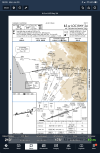



This. The MAP is pretty clear on where to go and how to get there. In the absence of other instructions, you'd just hold on the OCN R-145 in a standard hold.I'd fly runway heading to 3,000 then track the 145 radial to OCN and start making right turns and timing 1-minute legs.
The profile view missed seems clear to me. 245°, intercept R145, hold OCN.The Hold isn’t charted. You can’t get ahold of ATC to ask. How would you hold?
View attachment 152990

This is a great question, with unfortunately a less-than perfect answer that takes a bit of a winding road to get to. This will be a long one, with numerous official references.
A little background - for every approach or departure chart, there is an underlying "source" document - this is FAA Form 8260-3 or -5 for approaches. This form is what is produced by the TERPS elves and spells out all the details on how the procedure is to be charted by the charting agencies (or others, for example, Jeppesen). These forms are available to the public at the FAA's Instrument Flight Procedures Information Gateway at:
https://www.faa.gov/air_traffic/flight_info/aeronav/procedures/
(search for the airport, then the "IFP Documents" tab).
These do take a little practice to read (an understatement), as pilots are not the intended audience. However, they do often answer questions and offer insights into questions like these. For CRQ, the ILS form says the following for the missed approach holding pattern: "Hold West, Right Turns, 090 inbound (do not chart)".
So it's not charted because the procedure designer put "do not chart" on the form. But why?
There is typically no reason for us to put "Do Not Chart" on the form unless told to by some other agency, usually Air Traffic.
So, further research is needed.
Each fix and holding pattern in the U.S. has its own supporting documentation, because we do like paperwork. These are on FAA Form 8260-2, which, conveniently are publicly available at:
https://www.faa.gov/air_traffic/flight_info/aeronav/aero_data/radio_fix_holding_8260/
The form for the Oceanside VORTAC has this note: "Prior coordination required with controlling agency for holding over R-2503A, B and D".
The combination of the two gives us a good picture of the answer. If you look at the sectional or low enroute chart, you can see that OCN VORTAC is right at the edge of these restricted areas. So holding (in any direction) definitely extends into the R-area. Therefore, ATC requested it not be charted, presumably due to this situation, and I'm sure they intend to give radar vectors anyway.
I said this is a less-than perfect answer, and it is. The listener asks about lost comms. Since there is no way for the pilot to know the holding pattern direction, the only reasonable solution is to follow the standard guidance of holding on the inbound radial, right turns, 1-minute legs. And that will certainly be safe, there is no significant terrain to worry about here at the 3000 foot missed approach altitude.
This holding pattern does happen to be depicted on the VOR-A procedure, but there it is a hold-in-lieu-of-procedure-turn. Presumably if ATC is going to clear an aircraft for the VOR-A, they would have already had to effect coordination with the restricted area controlling agency.
Squawk 7600 and head towards better weather.Here’s a scenario -
What would you do if you lost communications right after being cleared for the approach, had to go missed and the forecasted weather did not require an alternate to be filed, but unexpectedly, the airport and surrounding coast line became IFR?
You have no filed alternate. Your clearance limit was to CRQ and now you’re holding at OCN unable to contact ATC. Now what?
And you hope there is better weather within 45 minutes (or hopefully more if you planned wisely).Squawk 7600 and head towards better weather.


Easy one. I would do exactly the same as I would do if I did file an alternate. Go wherever I decided at the time was my best option.Here’s a scenario -
What would you do if you lost communications right after being cleared for the approach, had to go missed and the forecasted weather did not require an alternate to be filed, but unexpectedly, the airport and surrounding coast line became IFR?
You have no filed alternate. Your clearance limit was to CRQ and now you’re holding at OCN unable to contact ATC. Now what?
I’ve found hope to be a very poor flight planning strategy.And you hope there is better weather within 45 minutes (or hopefully more if you planned wisely).
Things to ask your students.
Pretty much what the AIM says when it's not charted and there are no holding instructions given. In this case, standard direct entry hold on the 145° radial.The Hold isn’t charted. You can’t get ahold of ATC to ask. How would you hold?
Enter the MAP hold, ensure the autopilot is properly set up to keep me there, and then troubleshoot the radios, including trying Guard and other approach/center frequencies. If no joy, pull out my handheld radio and use that. Failing that, consider contacting ATC via cell-phone if possible. Failing that, exercise my PIC authority, squawk 7600, and proceed to VFR weather (if within range) or choose an airport with an approach/weather that seems viable, making calls in the blind. Happy to discuss with the authorities at zero knots and one G over a cup of coffee.Here’s a scenario -
What would you do if you lost communications right after being cleared for the approach, had to go missed and the forecasted weather did not require an alternate to be filed, but unexpectedly, the airport and surrounding coast line became IFR?
You have no filed alternate. Your clearance limit was to CRQ and now you’re holding at OCN unable to contact ATC. Now what?

That’s what I was thinking would be the thing to do. There is a holding pattern designated though. Question is, why don’t they want it Charted?Pretty much what the AIM says when it's not charted and there are no holding instructions given. In this case, standard direct entry hold on the 145° radial.
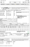
But what is the MAP hold? It’s not Charted.Enter the MAP hold, ensure the autopilot is properly set up to keep me there, and then troubleshoot the radios, including trying Guard and other approach/center frequencies. If no joy, pull out my handheld radio and use that. Failing that, consider contacting ATC via cell-phone if possible. Failing that, exercise my PIC authority, squawk 7600, and proceed to VFR weather (if within range) or choose an airport with an approach/weather that seems viable, making calls in the blind. Happy to discuss with the authorities at zero knots and one G over a cup of coffee.
What are you going to do if your autopilot fails?ensure the autopilot is properly set up to keep me there
Follow the FD bars.What are you going to do if your autopilot fails?
That's a good question. When I see something not charted, I usually think in terms of either chart clutter or ATC request. Maybe @RussR has an answer.That’s what I was thinking would be the thing to do. There is a holding pattern designated though. Question is, why don’t they want it Charted?
That's a good question. When I see something not charted, I usually think in terms of either chart clutter or ATC request. Maybe @RussR has an answer.
While we’re here, shouldn’t this Approach have an Alternate Missed Approach?The only real answer I have is what I posted in Post #8. It was by ATC request. No additional details, but I surmise due to the restricted areas.

While we’re here, shouldn’t this Approach have an Alternate Missed Approach?
WAG: If OCN goes out, there isn't another good available ground based navaid to use. MZB is almost 30 NM south. Seal Beach 45 NM north. And both in some pretty busy airspace.While we’re here, shouldn’t this Approach have an Alternate Missed Approach?

And you hope there is better weather within 45 minutes (or hopefully more if you planned wisely).
Things to ask your students.


That's a good question. When I see something not charted, I usually think in terms of either chart clutter or ATC request. Maybe @RussR has an answer.
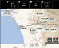
Actually, I could have answered "hold west on the 090 inbound" since Garmin Pilot charts it on their SmartCharts.
I'd fly runway heading to 3,000 then track the 145 radial to OCN and start making right turns and timing 1-minute legs.
If a missed approach procedure, wouldn't it be the 325 radial?
You're still on the 145 radial, you're just flying the 325 course TO the station.
The same thing I would have done a month ago before I got the autopilot installed: fly the airplane! Same stuff, just less efficient due to the need for increased vigilance on the instruments.What are you going to do if your autopilot fails?
The above discussion aside (where it turns out that it actually is charted but hidden, and a hold direction that could not be inferred by a pilot from the plate when used in anger, for reasons that make no sense to me), the MAP says to fly inbound on the OCN R145 at 3000 feet and hold. In the absence of anything on the chart to suggest otherwise or instructions to the contrary from ATC, a standard hold would be inbound on the radial, right-hand turns, and one-minute legs. Happy to be corrected on this, but I think that's the entire purpose of having "standard hold" rules because not every hold will be drawn on a plate/chart. In this case, it turns out there's some underlying goofiness, but I'd enter that standard hold on the OCN R145 and would happily defend that to any FSDO inquiry.But what is the MAP hold? It’s not Charted.
No. I just said it’s not charted.The above discussion aside (where it turns out that it actually is charted but hidden, and a hold direction that could not be inferred by a pilot from the plate when used in anger, for reasons that make no sense to me), the MAP says to fly inbound on the OCN R145 at 3000 feet and hold. In the absence of anything on the chart to suggest otherwise or instructions to the contrary from ATC, a standard hold would be inbound on the radial, right-hand turns, and one-minute legs. Happy to be corrected on this, but I think that's the entire purpose of having "standard hold" rules because not every hold will be drawn on a plate/chart. In this case, it turns out there's some underlying goofiness, but I'd enter that standard hold on the OCN R145 and would happily defend that to any FSDO inquiry.
Are you taking the position that any hold which isn't graphically shown on a plate is undefined? Not sure I'm understanding.
The above discussion aside (where it turns out that it actually is charted but hidden, and a hold direction that could not be inferred by a pilot from the plate when used in anger, for reasons that make no sense to me), the MAP says to fly inbound on the OCN R145 at 3000 feet and hold. In the absence of anything on the chart to suggest otherwise or instructions to the contrary from ATC, a standard hold would be inbound on the radial, right-hand turns, and one-minute legs. Happy to be corrected on this, but I think that's the entire purpose of having "standard hold" rules because not every hold will be drawn on a plate/chart. In this case, it turns out there's some underlying goofiness, but I'd enter that standard hold on the OCN R145 and would happily defend that to any FSDO inquiry.
Are you taking the position that any hold which isn't graphically shown on a plate is undefined? Not sure I'm understandin
Fair enough, that's true. Not looking for an argument at all. It's my understanding that in the absence of clear direction otherwise on the chart, a pilot would reasonably assume a direct entry to the R145 hold with righthand turns and 1 minute legs. I'm unclear how a pilot would be expected to know the required hold from just looking at a standard/Jepp plate. Where did you find the procedure description you posted above? I haven't seen that before.No. I just said it’s not charted.
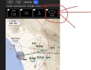
Indeed! This is a weird one, and if you're flying using the SmartChart, there is indeed a hold on the 090 radial and a parallel entry would make sense. I can only assume that Garmin's systems are digging into the system to show the procedure and merrily ignoring the "do not chart" request. One more reason to like SmartCharts!With Garmin Pilot in looking at the written instructions, your holding the the 145 (325) radial, right turns, one minute leg.. direct entry - depicted in blue...
Garmin pilot agrees with that, however depicts a parallel entry in the instructions that would have you holding on the 090 radial as it is published.. How does one reconcile that?
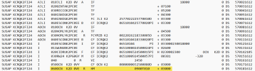
Because that’s actually the missed hold as described in the 8260 - the regulatory document that defines the approach. See @luvflyin’s posting if the document earlier. The R145 is just how you get to the holding fix. It doesn’t define the hold.Garmin pilot agrees with that, however depicts a parallel entry in the instructions that would have you holding on the 090 radial as it is published.. How does one reconcile that?
That’s exactly what they are doing. Creating a chart based on the regulatory source document , not the FAA -specific charting instructions.I can only assume that Garmin's systems are digging into the system to show the procedure
I’m not looking to argue either. Holding in a standard pattern on the radial you arrive at the Fix on were my thoughts also.Fair enough, that's true. Not looking for an argument at all. It's my understanding that in the absence of clear direction otherwise on the chart, a pilot would reasonably assume a direct entry to the R145 hold with righthand turns and 1 minute legs. I'm unclear how a pilot would be expected to know the required hold from just looking at a standard/Jepp plate. Where did you find the procedure description you posted above? I haven't seen that before.
Indeed! This is a weird one, and if you're flying using the SmartChart, there is indeed a hold on the 090 radial and a parallel entry would make sense. I can only assume that Garmin's systems are digging into the system to show the procedure and merrily ignoring the "do not chart" request. One more reason to like SmartCharts!