GTN 750 Arrival Procedure

the400kid

Pre-takeoff checklist
Joined
Sep 2, 2013
Messages
131
Display Name

Display name:
FLAAV8R
For the first time since I had the GTN 750 installed, I was given an arrival. I was flying from Tallahassee (KTLH) to Boca Raton (KBCT). The route called for TLH, KCTY (Cross City), LAL (Lakeland), PHK (Pahoke) direct KBCT.

Between Lakeland and Pahoke, I was assigned the TTYLR3 arrival. I had no problem calling it up on the Procedures screen, but the arrival has three transitions and all of them were behind me. I improvised by loading the arrival using St Pete (PIE) as the transition, and once loaded, pressed the Direct To button to take me to TTYLR, where it continued to sequence everything properly.

My question is, was there a more efficient way of loading the arrival without having to use one of the transitions?
 
Select a leg between the next fix and the closest one behind you.
 
I re-read your post, looked at the arrival and think I understand it better now. I had the same quirk going into Atlanta. They gave me the fix that is the "joining point" for all the feeders. That doesn't show up as a transition in a GTN. It makes little sense to me, but what you did is the best thing I can think of. The fix will show up and just hit direct-to. In my opinion, it's goofy but no one at Garmin asked me.

Did ATC give you TTYLR as a transition?

My initial reply was for a different scenario, please ignore.
 
I fly into F45 a lot. Most times I’m given the Ttylr3 arrival. Like you I’m always already past the transition points. I just fly direct Ttylr then fly a heading as depicted. I never load the transition procedure.
i’ve had the same questions
 
Please elaborate.
It's exactly the same process as entering an airway you plan to intercept. You have to create the leg you are going to intercept. The entry point may be behind you (and yes, for those who have seen it, that's one of the 6 GPS tasks I look at during IPCs and recurrent training). You choose the one that makes the most sense based on where you are.
 
I fly into F45 a lot. Most times I’m given the Ttylr3 arrival. Like you I’m always already past the transition points. I just fly direct Ttylr then fly a heading as depicted. I never load the transition procedure.
i’ve had the same questions
What fun is that when you have GPSS to do all the hard work?
 
I had no problem calling it up on the Procedures screen, but the arrival has three transitions and all of them were behind me.
First of all, ATC should tell you how they expect you to join the arrival, and they should tell you which transition to use, such as:
"N12345, proceed direct TTYLR, join the TTYLR3 arrival" - maybe that's what happened here?

Then: When it comes to loading the arrival, the GPS units for some reason don't show a transition-less option - you were probably offered PIE.TTYLR3. PGD.TTYLR3 and RACNO.TTYLR3. What you really wanted is TTYLR.TTYLR3, but that doesn't show up in the list. So you did the right thing by selecting one of the others and then going direct to TTYLR, skipping the waypoints before TTYLR. I am not aware of a better way of doing that in the GTN, GNS or IFD navigators.

- Martin
I was told to "join the Tyler Three arrival" and then my frustrations started from there. Thanks for backing up my keystrokes, I sat there flustered thinking there had to be a better way, but I guess not.
 
I was told to "join the Tyler Three arrival" and then my frustrations started from there. Thanks for backing up my keystrokes, I sat there flustered thinking there had to be a better way, but I guess not.
As @Martin Pauly said, we usually expect ATC to say seeming more. Maybe "direct TTYLR to join the arrival" or " fly heading XXX to join the arrival." But I guess since you were on the LAL PHK leg which ultimately intersects the TTYLR-PBI leg of the arrival, they just expected you to continue on course until intercepting it.
1689708852395.png

You did just fine selecting PIE. I probably would have selected RACNO because it was closer to my route of flight but on this one it doesn't matter since the only leg that makes sense is TTYLR-PBI and all the transitions ultimately go there.

But just think... your experience and questions about it taught you a very basic GPS skill.
 
It works this way in every FMS or Navigator, to my knowledge. You'll have to load a transition that contains the fix at which you'd like to start the arrival, even if you don't need those "extra" fixes.
 
Old thread here, but it did get me thinking. Of all the times I've been given the an Arrival, ATC has never told me which Transition. I 1) look at the arrival chart and finding the route that makes sense, 2) bring the arrival up on the GTN, 3) hit Direct to the fix that makes sense for the start, and 4) Tell ATC I'm flying the XYZ Arrival, heading direct to whatever fix I'm using. That has always seemed to do the trick. When I have asked before "Which Transition to the Arrival?" I've never gotten a clear response.
 
It's exactly the same process as entering an airway you plan to intercept. You have to create the leg you are going to intercept. The entry point may be behind you (and yes, for those who have seen it, that's one of the 6 GPS tasks I look at during IPCs and recurrent training). You choose the one that makes the most sense based on where you are.

I do this with students too (intercepting an airway between fixes). What are the other 5 you do?
 
I do this with students too (intercepting an airway between fixes). What are the other 5 you do?
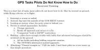
Mine are used in recurrent training - flight reviews, checkouts, avionics transition training. The last one is recent. Did it to someone and was incredibly surprised. Then it happened on the next flight with someone else. And then the next. Each pilot had a different reason for the error. The old #6 was about loading an approach to an alternate while maintaining the current flight plan (including the missed). I moved it into an "Extra Credit" item because it's a bit more in the "tips and tricks" category.

Most of them come from real events, including IFR accidents. The "switch or reload approach" originally came from a fatal accident. Others came from questions raised either in forums or by friends calling me to talk about an issue they encountered.
1694352092825.png

I've been contemplating another involving stepdowns outside the FAF on RNAV approaches without enroute VNAV guidance. Funny that it was a Jerry problem on the KOAK RNAV 28R approach. No, it didn't lead to "secondary minimums." It led to his approach checklist item to switch to VTF, which is not a bad solution for his equipment although he unnecessarily applies it to approaches where he doesn't need it..

The goal is to choose tasks that happen regularly. I don't try to mess with people by making up weird tasks. And the goal is to see if they can, not whether I like the way the do it. If it works, it works. And while we can do them all in flight, I do some of them on the ground if we have the simulation apps to do it.
 
The old #6 was about loading an approach to an alternate while maintaining the current flight plan (including the missed). I moved it into an "Extra Credit" item because it's a bit more in the "tips and tricks" category.

I'm stumped on this one. Using the GTN simulator, I added the alternate airport to the end of the flight plan, then expected to be able to load an approach and have it append to the existing flight plan which would be the missed approach hold as the final fix. The only option I was given was to load AND activate.

So how is this accomplished?

Not to hijack the thread, but...

I would appreciate your comments on a video from "master CFII" Gary Reeves


Could you comment on what he is saying regarding CDI deflection starting at 6:50. I'm not sure what he is saying is correct.

Secondly, at 40:20 he advises in the light GA world, pilots should disable the VNAV feature of their autopilots because VNAV will hide a glide path. If the approach mode is armed during VNAV, I'm not sure why the glide path will be hidden. Any comments on this.

I'm asking because I'm considering upgrading to a GFC 500 with my GTN.
 
Last edited:
Secondly, at 40:20 he advises in the light GA world, pilots should disable the VNAV feature of their autopilots because VNAV will hide a glide path. If the approach mode is armed during VNAV, I'm not sure why the glide path will be hidden. Any comments on this.

I'm asking because I'm considering upgrading to a GFC 500 with my GTN.

Garmin changed the way VNAV works, IIRC it use to end at the IAF/IF, now I think you use to FAF. I assume the glide path will take precedence when established, approach is armed.
 
I'm stumped on this one. Using the GTN simulator, I added the alternate airport to the end of the flight plan, then expected to be able to load an approach and have it append to the existing flight plan which would be the missed approach hold as the final fix. The only option I was given was to load AND activate.
Depends on your equipment. The latest GTNs allow you to add another approach once you are in the missed hold. The IFD let's you do it any time. For the rest, the best way is to set it up in the flight plan catalog to be quickly retrieved. Just remember not to use the PROC button - that's dedicated to the currently active flight plan.
I taught this one to my CFI during an IPC he was giving me. We planned on three approaches. i set the second two up in the catalog.
 
Secondly, at 40:20 he advises in the light GA world, pilots should disable the VNAV feature of their autopilots because VNAV will hide a glide path. If the approach mode is armed during VNAV, I'm not sure why the glide path will be hidden. Any comments on this.
No longer necessary. If VNAV and GP are both armed, enroute VNAV will be used until the FAF becomes the active waypoint, then automatically switch to GP.

Sorry, no time right now to check the other one.
 
Could you comment on what he is saying regarding CDI deflection starting at 6:50. I'm not sure what he is saying is correct.
if you are talking about the 0.1 mile full-scale deflection, I think Gary is correct. I'm sure someone else can explain it much better than I (@RussR, @John Collins) but the basics can be found buried in AIM 1-1-8.d.4 (snipped and emphasized). Essentially, if I understand correctly, where LOC is by nature angular (tighter as you get closer to the runway), GPS and WAAS are lateral. With both you have that 0.3 for the FAS. Add WAAS and it sort of mimics Localizer performance up close by dropping to 700' (0.133 nm) at the runway threshold.

There are two differences in the WAAS scaling and ILS: 1) on long final approach segments, the initial scaling will be ±0.3 NM to achieve equivalent performance to GPS (and better than ILS, which is less sensitive far from the runway); 2) close to the runway threshold, the scaling changes to linear instead of continuing to become more sensitive. The width of the final approach course is tailored so that the total width is usually 700 feet at the runway threshold.
 
if you are talking about the 0.1 mile full-scale deflection

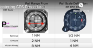
I was wondering about full scale terminal and enroute deflection. I double checked my GTN manual and AIM and I think he's got it wrong. I'm just wondering if I'm missing something.

1694435268096.png
 
I was wondering about full scale terminal and enroute deflection. I double checked my GTN manual and AIM and I think he's got it wrong. I'm just wondering if I'm missing something.

View attachment 120521
I think the key words are "on one side" on the pic on the right. And "full range" on the left pic
 
I think the key words are "on one side" on the pic on the right. And "full range" on the left pic

I always thought full scale deflection was the amount of deflection of the needle from the center to full swing of the needle (or HSI equivalent) on one side or the other. Like VOR full scale defection is 10 degrees. Full range of travel would be full deflection X 2.

Here's a snip from the Garmin GTN manual.

1694477705035.png

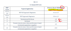
Table 1-2-1 from the AIM:

1694477853581.png
 
I always thought full scale deflection was the amount of deflection of the needle from the center to full swing of the needle (or HSI equivalent) on one side or the other. Like VOR full scale defection is 10 degrees. Full range of travel would be full deflection X 2.

Here's a snip from the Garmin GTN manual.

View attachment 120538

Table 1-2-1 from the AIM:

View attachment 120539
You thought right. I like to include obstacle awareness in these thoughts. See slide #42 and on: https://www.avclicks.com/presentations/Intro_to_GPS/
 
if I understand correctly, where LOC is by nature angular (tighter as you get closer to the runway), GPS and WAAS are lateral. With both you have that 0.3 for the FAS. Add WAAS and it sort of mimics Localizer performance up close by dropping to 700' (0.133 nm) at the runway threshold.
Let me offer the following explanation:

- VOR and LOC are angular - yes, the sensor/radio natively outputs an angular difference between where the plane is and where the plane should be. That angular difference is simply shown to the pilot on the deviation indicator (dots left or right).

- GPS, whether with or without WAAS, outputs a position (and yes, velocity and time, too) in latitude, longitude and altitude. A computer program has to compare that position (where the plane is) with the active leg on the flight plan (where the plane should be). That difference can be expressed in many different ways, including the distance (lateral offset) between the active leg and the current position. That distance is what was originally chosen for GPS navigation guidance, and flying enroute that makes a lot of sense.

- Another way this difference can be expressed is an angular deviation, as seen from the active waypoint (how many degrees is the plane away from the active leg). It's just different math. SBAS doesn't enable the principle, it merely increases the accuracy to the point where ILS-like minimums can safely be flown this way.

- This angular method was chosen for LPV and LP approaches, except to be perfectly accurate it's the angular deviation not from the active waypoint (which is the runway when flying the final segment), and not the far end of the runway either (where the localizer antenna would be if there was one); but from a fictitious point chosen such that full-scale deflection smoothly transitions from what it is in terminal mode to 700' (full left to full right) over the runway threshold, so it feels just like a "real" ILS at the time of touchdown.

- Martin
 
Could you comment on what he is saying regarding CDI deflection starting at 6:50. I'm not sure what he is saying is correct.

Secondly, at 40:20 he advises in the light GA world, pilots should disable the VNAV feature of their autopilots because VNAV will hide a glide path. If the approach mode is armed during VNAV, I'm not sure why the glide path will be hidden. Any comments on this.

I'm asking because I'm considering upgrading to a GFC 500 with my GTN.

Full scale is not correct in his video. In terminal mode, full scale deflection (FSD) is based on the PBN RNAV 1 specification or RNP APCH specification and is 1 NM. Full scale is the offset from the center of the indicator, so for RNAV 1 it is +/- 1 NM. So from full scale to the left all the way to full scale to the right is 2 NM, 1 NM to left to center and 1 NM more from center to the right. TERPS doubles the FSD in defining the protected airspace, so for an RNAV 1 route segment, the primary area is protected to +/- 2 NM, or a total of 4 NM across. The main difference is with the enroute specifications for the legacy RNAV, which was a FSD of +/- 5 NM or RNAV 5 (+/- 5 NM) verses the WAAS GPS which uses RNAV 2 with a FSD of +/- 2 NM. T routes are RNAV 2, and the primary protected area is +/- 4 NM, or 8 NM wide, the same as for a V airway.
 
Let me offer the following explanation:

- This angular method was chosen for LPV and LP approaches, except to be perfectly accurate it's the angular deviation not from the active waypoint (which is the runway when flying the final segment), and not the far end of the runway either (where the localizer antenna would be if there was one); but from a fictitious point chosen such that full-scale deflection smoothly transitions from what it is in terminal mode to 700' (full left to full right) over the runway threshold, so it feels just like a "real" ILS at the time of touchdown.

- Martin

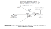
It is optional in the WAAS TSO to show the LNAV lateral deviation after the FAF as either linear +/- 0.3 NM or angular at +/- 2 degrees with the proviso that it does not exceed 0.3 NM inside the FAF. This is the way Garmin implements it in the GNS, GTN, and G1000 series. Garmin had a bug in their LNAV angular implementation at one point that allowed it to exceed the +/- 0.3 NM inside the FAF whenever the FAS was particularly long. Until Garmin fixed the issue, some approaches were eliminated from the data base. This is from the TSO RTCA DO-229 specification for LNAV FSD. For the most part, a WAAS GPS is going to use angular +/- 2 degrees. Note that the origin is 10,000 feet past the threshold, making 10,000 X Tan (2) = 350 feet, same as ILS.

RTCA DO-229 LNAV FSD.png
 
Secondly, at 40:20 he advises in the light GA world, pilots should disable the VNAV feature of their autopilots because VNAV will hide a glide path. If the approach mode is armed during VNAV, I'm not sure why the glide path will be hidden. Any comments on this.

I'm asking because I'm considering upgrading to a GFC 500 with my GTN.

I agree with his point and I turn off VNV after loading the approach into my GTN. This is because I have a legacy AP (Stec 60-2) that does not follow the VNV guidance. Typically, I don't make the GP intercept at the GP intercept altitude, but rather at the higher crossing altitude of the IF. Usually this is a 500 foot descent to get down to the FAF crossing altitude, so at 3 degrees it just means I will intercept the GP about 1.6 NM before reaching the FAF rather than making a descent to the FAF crossing altitude and intercept from there. In effect the VNV would do the same thing as it begins the descent to arrive at the FAF at the intercept altitude. If I leave VNV enabled, my autopilot won't follow the VNV descent and the GTN does not switch from VNV to GP until the FAF, so when it switches, I am 500 feet too high to intercept. With the VNV disabled, I remain at the higher altitude, intercept the GP a little further out at essentially the same point the VNV would have begun the descent, but my GP will be intercepted and followed. All I need to do in my Bonanza, is lower the landing gear when I intercept the GP. EZ PZ.
 
For the first time since I had the GTN 750 installed, I was given an arrival. I was flying from Tallahassee (KTLH) to Boca Raton (KBCT). The route called for TLH, KCTY (Cross City), LAL (Lakeland), PHK (Pahoke) direct KBCT.

Between Lakeland and Pahoke, I was assigned the TTYLR3 arrival. I had no problem calling it up on the Procedures screen, but the arrival has three transitions and all of them were behind me. I improvised by loading the arrival using St Pete (PIE) as the transition, and once loaded, pressed the Direct To button to take me to TTYLR, where it continued to sequence everything properly.

My question is, was there a more efficient way of loading the arrival without having to use one of the transitions?

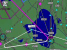
You did this procedure correct. That’s exactly what we do flying as airline pilots. Not on a 750 but in the FMS. The process is exactly the same.
 
Last edited:
First of all, ATC should tell you how they expect you to join the arrival, and they should tell you which transition to use, such as:
"N12345, proceed direct TTYLR, join the TTYLR3 arrival" - maybe that's what happened here?

Then: When it comes to loading the arrival, the GPS units for some reason don't show a transition-less option - you were probably offered PIE.TTYLR3. PGD.TTYLR3 and RACNO.TTYLR3. What you really wanted is TTYLR.TTYLR3, but that doesn't show up in the list. So you did the right thing by selecting one of the others and then going direct to TTYLR, skipping the waypoints before TTYLR. I am not aware of a better way of doing that in the GTN, GNS or IFD navigators.

- Martin

ATC will NOT give you the transition if your joining the STAR past all of the transition points. Having been in the OP’s situation weekly, If you’re past the transition, ATC will give you a fix on the STAR and have you join the arrival from there as you stated.

It’s up to you to load the transition and find the fix. Generally it’s deep enough in the STAR that any transition will work.

This process happens all the time at the airlines, especially in busy airspace where arrivals change frequently for a myriad of reasons.
 
Last edited:
ATC will NOT give you the transition if your joining the STAR past all of the transition points.
Yes - I think we are saying the same thing. If it matters which transition to pick in the GPS when loading the arrival, ATC will tell you which one it is. So the absence of a transition in the ATC clearance means "it doesn't matter" - just load any one and fast-forward to the desired downstream waypoint.

- Martin
 
What you describe is a pretty common procedure when cleared to join an arrival and are already inside fixes on the transitions. In most cases the only "programming" difference is how the unneeded fixes are deleted.
 
Back
Top