EFB for VFR pilot

Greg Bockelman

Touchdown! Greaser!
PoA Supporter
Joined
Feb 23, 2005
Messages
11,346
Location
Lone Jack, MO
Display Name
Greg Bockelman
Home Airfield
KLXT KLRY 87MO
Once upon a time, I was a subscriber to ForeFlight. Now I am strictly a VFR pilot. I am going to be in possession of a Stratux ADSB receiver in the near future. What would be the best EFB to run it on for me?
 
What would be the best EFB to run it on for me?
Also, it would be helpful to know what you need from it. Basic chart reader plus traffic and weather? Full flight planning including briefing and filing? Something in between?
 
I’ll probably stay with ForeFlight. A number of reasons. Famiarity. Excellent flight planning tools. Connectivity with the Garmin panel systems I fly. And it looks like the new enhanced taxi diagrams are part of the aeronautical layer, so you basically get georeferenced taxi diagrams at a lower subscription price point.

If not, as a purely VFR pilot with a universally capable portable ADS-B receiver, iFlyEFB. I have not played with it for a few years now, but I think it’s the best bang for the buck for VFR. And it’s multi-platform if you care about that.
 
Consider Fltplan Go, free (for now) and works well with a Stratux on an iPad, don't know about Android universe.
 
Fltplan go or FF are great
 
Once upon a time, I was a subscriber to ForeFlight. Now I am strictly a VFR pilot. I am going to be in possession of a Stratux ADSB receiver in the near future. What would be the best EFB to run it on for me?

Any app with a digital chart and a little airplane icon showing where you are provides more than 90% of what you really need. Everything beyond that is mostly bells and whistles.

I’m a strong advocate for reducing technology clutter in the cockpit. More information and more features do not necessarily make flying safer or easier. At some point, they create more things to configure, monitor, and manage when your attention should be on the airplane.

I like AvareX because it fits the above model well. However, they are also moving towards adding more bells and whistles.
 
Also, it would be helpful to know what you need from it. Basic chart reader plus traffic and weather? Full flight planning including briefing and filing? Something in between?
Ultimately, this is the answer. All we “need” from an EFB is a sectional and a source of CS information. And depending on our avionics, we may not even need that.

The real question is what you “want.” There are some new entrants, but I’ve tried and played with most of the EFBs in the US market (there are a half dozen on my iPad now). There are a lot of choices out there.
 
What I NEED is an airplane symbol on a moving map displaying a sectional. What I WANT is to be able to tap on an airport and get AFD type information. What I WANT is to get basic 6-pack information displayed in whatever form.

Basically I am looking for the most bang for the fewest bucks for a VFR pilot.
I've been using FltPlan Go for a year. It is free and uses Garmin information. It is good for VFR. I tried AvareX (several times) but it never worked well for me although I recognize some people think it is great. There was one AvareX update that lost KLNK (Lincoln, NE, Class C airport), for example. I haven't registered as a FltPln user as yet although I'm considering it. I get airport information when I tap on an airport in the chart.

I mostly use it to get a plane showing on a chart. I use it on an iPad, it is a bit clunky on a Samsung phone. It can display flight instruments although I don't use that feature, partly because it takes too much screen space. ForeFlight has a smoother interface although I may simply be more used to that program. FltPln Go appears to show Canadian charts without any subscription, but has no other international charts other than a base world map with major cities.

It appears my needs are similar to yours- it is free to try, as is AvareX.
 
It's not free, but I do like Garmin pilot for VFR flight. You get good weather, TFR, etc info for flight planning, can display traffic and weather on the moving map, etc.

I know there are other products, but the touch ring (touch on the place you're interested in and be able to see distance, airport info, airspace info, weather, quickly is really usable for me.
 
Tell me more!

FAA publishes chart data in 2 formats. Most EFBs display both, but I think a few of the freebies may only do rasters.

Vector charts are formula-based graphics. That allows charts to add and reduce detail at different levels of zoom, and scale text and graphics to always be readable. You can also select graphics to display or hide.

Raster charts are pixel-based images, identical to a paper sectional.

All sensible pilots prefer vectors.

Just kidding. It is a matter of preference.
 
Big fan if iFly EFB! Excellent customer service. Always improving the software. Real straightforward system that's been reliable and useful. Doesn't require an Apple product. I'm a fan.
 
[FltPlanGo] is free to try, as is AvareX.
Both are simply free. I suppose "free to try" is a property of simply being free, but not necessarily the reverse. Which leads me to...

1. Install all the free apps.
2. Delete the ones you don't like.
3. If you get to zero apps, start installing the ones that are paid but free to try.
4. Delete the ones you don't like.
5. Go back to ForeFlight.

@Greg Bockelman Let us know how far down you get to the list
 
@Greg Bockelman I forget if your are based in the lower 48 or somewhere more exotic. I seem to recall that could be the case and could drive what is available to you.

For many years, I used Avare. It just worked, but was kind of clunky. Then, I went to iFly after trying out FF amd GP. iFly EFB worked well for me for both IFR and VFR as a paid for EFB that had parity in features and capability across iPad and Android. And it still does. There’s minor nits to pick like supremely easy, two-click access to the actual AFD page, but the date is there within in or two clicks, just not as a PDF page.

I switched to Garmin Pilot only because we bought a plane that allowed two way flight plan transfer and engine monitor data transfer via the EFB.
 
I’m starting with FltPlan Go. I will see how that works for me for awhile. It’s going to be a little while before I can give it a proper try.
 
It's not free, but I do like Garmin pilot for VFR flight. You get good weather, TFR, etc info for flight planning, can display traffic and weather on the moving map, etc.
That’s interesting. I subscribe to Garmin Pilot (as well as ForeFlight). I think it’s a great IFR app, but will drop it if I stop flying IFR.
 
Both are simply free. I suppose "free to try" is a property of simply being free, but not necessarily the reverse. Which leads me to...

1. Install all the free apps.
2. Delete the ones you don't like.
3. If you get to zero apps, start installing the ones that are paid but free to try.
4. Delete the ones you don't like.
5. Go back to ForeFlight.

@Greg Bockelman Let us know how far down you get to the list
I phrased it poorly. FltPlan Go is free to use as long as you wish, over a year in my case. It is still "free to try" too as you allude to.

Your numbered list should work, although I haven't felt the need to do #5.
 
Last edited:
I would double down on my goal to check Garmin Pilot then. It has a unique way to tap and get info that I think is very easy to use and doesn't require "learning" the app the way Foreflight and others do.

I would also caution against "try all the free ones and see what I like". If your primary goal is cost, that's a good approach, but if your primary goal is what is the best tool to give me situational awareness and help keep me safe, I would look at paid and unpaid and pick the one you like best.
What I NEED is an airplane symbol on a moving map displaying a sectional. What I WANT is to be able to tap on an airport and get AFD type information. What I WANT is to get basic 6-pack information displayed in whatever form.

Basically I am looking for the most bang for the fewest bucks for a VFR pilot.
 
I was an iFly user and was very happy with it and it's simplicity. When I purchased my own airplane it came with a Garmin suite that included the GPS, ADSB, weather, etc. and Garmin Pilot allowed my iPad to integrate with all of that. I can upload flight plans from the iPad to the GPS, modify flight plans, follow the weather and traffic on the tablet too. It makes my iPad an extension of my navigation suite. If I enter a "direct to" on the GPS, the iPad instantly displays the updated route and data. Flight planning is easier to do on the iPad, than in the airplane.
 
What I NEED is an airplane symbol on a moving map displaying a sectional. What I WANT is to be able to tap on an airport and get AFD type information. What I WANT is to get basic 6-pack information displayed in whatever form.

Basically I am looking for the most bang for the fewest bucks for a VFR pilot.
Avare will do the first two things. Not sure if it'll do the last one. It'll give you gps based altitude, speed, course. To get horizon I think you need an input source that has gyro equivalent. I don't think most Stratux solutions do that. Not sure if Avare the capability to do that six pack thing at all.

Re Avare and AvareX, I have both on my androids. To me the user interface of old avare is simpler and easier, but averx has the ability to upload and download flight plans to the faa service. Avare is supposed to do that, but it's never worked for me. That said, I just use the 800 flight brief website to fly flight plans and get briefings. Avare will get weather, though, and give you crosswind and such for runways, and let you do moving maps on approach charts, switch between sectional and IFR low, etc. It's just not fancy. Like a 430, it doesn't understand routes for planning, you have to build them. But it works, and I like it.

If foreflight were upgraded to support android, I might take a look, but being limited to that platform is a deal breaker for me.
 
I’m starting with FltPlan Go. I will see how that works for me for awhile. It’s going to be a little while before I can give it a proper try.
If you create a free account with FltPlan.com any flight planning you do there (VFR or IFR) will propagate to your tablet app and you can get your weight and balance information also.
 
Any app with a digital chart and a little airplane icon showing where you are provides more than 90% of what you really need. Everything beyond that is mostly bells and whistles.

This is an interesting statement, because at first glance I agreed, but then I started thinking (which is often dangerous). And I might make an argument that depending on the avionics in the airplane, the airplane on a map might actually only be 10%, and the AFD, weather, flight planning type information could be the 90%.

I know I've flown entire VFR flights only occasionally looking at the iPad, and when I did it was to look something up, where it was easier to do (or only available) with the iPad than through the avionics.
 
You don't "need" bells and whistles, in the same way you don't "need" GPS or ADS-B ... but it sure as heck makes traveling more enjoyable and safer.

Having a moving map with your position, airspace, traffic, weather, and distance/speed/fuel calcs is near miraculous to those of us who grew up timing compass legs and tracking VORs.
 
I’ll put in another vote for iFly. I started out with Foreflight, but I’ve been using iFly for 4 or 5 years now. I think the UI is better, and iFly’s customer support beats FF hands down. I have iFly running on an iPad Mini, and I have an iFly 740b mounted to my panel. I can plan and brief on the iPad, then sync it to the 740b.

I believe iFly still offers a free trial, so you can give it a flight or two and see how you like it.
 
This is an interesting statement, because at first glance I agreed, but then I started thinking (which is often dangerous). And I might make an argument that depending on the avionics in the airplane, the airplane on a map might actually only be 10%, and the AFD, weather, flight planning type information could be the 90%.

I know I've flown entire VFR flights only occasionally looking at the iPad, and when I did it was to look something up, where it was easier to do (or only available) with the iPad than through the avionics.

It's interesting you say that, because I do all of the planning, weather etc.. on the ground (on a laptop or desktop which is far more convenient for my fingers than a tablet).
In flight, I really only look at where I am on the digital chart. I would also consider ADSB-traffic as essential. The Chart Supplement is very useful, which I occasionally check if I had forgotten to look at it on the ground, but I would consider that as part of the "digital chart".
 
It's interesting you say that, because I do all of the planning, weather etc.. on the ground (on a laptop or desktop which is far more convenient for my fingers than a tablet).
That's also a function of what EFB you use. Some are friendlier than others when it comes to planning. I think I mentioned earlier that, althoug I subscribe to both GP and FF, I would drop GP if I limited myself to VFR flight. Flight planning is the reason. I think you use Avare/Avarex. Yeah, having tried both, I'd be doing my flight planning on a PC too. Do they still require a series of waypoints to be entered one by one by one rather than as a string?
 
What I NEED is an airplane symbol on a moving map displaying a sectional. What I WANT is to be able to tap on an airport and get AFD type information. What I WANT is to get basic 6-pack information displayed in whatever form.

Basically I am looking for the most bang for the fewest bucks for a VFR pilot.
As others have said FltPlan Go is free (as long as you only store the information for no more than 10 airplanes) and I have used it that way since 2018. It will show an airplane symbol on a moving map as well as weather. You can't tap on an airport to get AFD information but on the app you can type in an airport and get all that information. For flight planning it will show routes, by aircraft type and altitude, that ATC frequently gives as well as routes frequently requested. For weather you will get METARS, Forcasts (both TAF and MOS), and all NOTAMS. The only drawback, to some people, that FltPlan Go has are that the IFR Charts are in NOS format not Jepps. But again it's free.
 
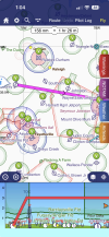
BTW, my conversation with @M20K in the raster vs vector thread reminded me. I really should mention Sky Demon. It's a popular European EFB marketed for VFR flight. This past years they added US support. I did some beta testing for them. Biggest downside for some will be the lack of raster charts. For others, sort of like iFly, the look and feel is very different from FF and GP. But it really does it's job well and it's multi-platform - iOS, Android, Windows. This screen capture is from am iPhone.
1789923963474.png
 
I’m currently a strictly vfr pilot.and I have used foreflight for years,so I downgraded my subscription to the basic subscription.
 
Back in the olden days I used Avare all the time on my Android tablet. I started with Garmin Pilot, but took a break from flying, let the subscription expire, and never went back. I was VFR only and Avare was all I needed. Eventually I started instrument training and continued to use Avare. I used it for my checkride. The Android finally wore out and I got an iPad. Avare won’t work on an iPad so I moved over to FltPlanGo. I’ve used FPG for VFR and IFR ever since. Then AvareX came out so I installed it on the iPad. The user interface and a few other operations were different enough from Avare, and I had gotten familiar enough with FPG that I just never got comfortable with AvareX. I still play with it and keep it updated, though.

I’m a recreational flyer, so almost all VFR, but I do practice approaches for the challenge.
 
I’ll put in another vote for iFly. I started out with Foreflight, but I’ve been using iFly for 4 or 5 years now.

I have also been on iFly about 5 years. In the first year I had some stability issues, but I think they have sorted that out.

I repurposed my old pixel phone as a dedicated EFB. Pulled the sim card, turned off the cellular radio, and removed all apps except iFly. My current phone is my backup device.

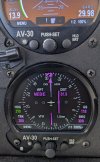
I have an edge case for usage. I connected a Bluetooth-to-serial adapter to my AV-30 HSI. iFly will push GPS nav data via BT, so heading and distance are displayed on my panel. I can also display traffic overlaid on course.

PXL_20250926_194509698.jpgPXL_20250926_194542205.jpg
 
Back
Top