Airports with no Weather

Learnin’ to fly…

Pre-takeoff checklist
Joined
Apr 11, 2023
Messages
236
Display Name
Learnin’ to fly…
Hi all
I fly out of an airport with no weather , so listen to a nearby field’s ATIS (usually by phone).

I generally look at a few as part of my brief - and for a while had been thinking about building a tool that grabs the current ATIS from several of the closest airports, weights them appropriately (or attempts to), and returns a concise digital summary.

After building and playing with the outputs for a while, I’m actually really happy with it.

Thought others might find it interesting/useful. Obviously for informational purposes, not official weather, only rely on actual atis/metars and observed conditions, limit one per house, and not to be combined with any other offer, (etc,etc).

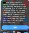
Thought others might find it helpful and it’s really easy to do. Here’s an example of the output:

If interested, here’s how to do it: use shortcut (iPhone), list the airport ids that you want, query aviationweather.gov, feed the inputs to ChatGPT, expose the results as an iPhone message. Once built - tap to result is 8-10 seconds (I’m using 4 nearby fields).Took me about 20 min to build. Simple and free
 

Attachments
  • IMG_2094.jpeg
    IMG_2094.jpeg
    285.3 KB · Views: 32
Last edited:
While I confess I don't have use for the specific application, I am interested in the mechanics of your process.
Mind entering more detail on how each step is carried out
Thanks.

here’s how to do it:

use shortcut (iPhone),

list the airport ids that you want,

query aviationweather.gov,

feed the inputs to ChatGPT,

expose the results as an iPhone message
 
You might want to have it take in both the no ATIS airport and the candidate airports and do some prompt engineering for it to check that they aren’t beyond some distance threshold to prevent typos. Whenever you’re asking a LLM to do math there’s hallucination risk, granted most model APIs are probably doing some agentic stuff and code generation under the hood to prevent that nowadays.

If you’re interested in some vibe coding, I’m sure it would be easy to vibe code a small iPhone app that looks up the N closest airports with weather data and then does some basic averaging (like an inverse distance weighted average) to produce the final result.
 
You do realize uncontrolled airports do not have ATIS.
I’m not sure why lack of an ATIS is an issue. Lots of uncontrolled airports have METARs and/or ASOS/AWOS one minute weather. Lots even have TAFs. So he has plenty of sources of data.
 
While I confess I don't have use for the specific application, I am interested in the mechanics of your process.
Mind entering more detail on how each step is carried out
Thanks.
Yes, certainly. What I started off trying to do was an automated transcription of the ATIS, essentially what ForeFlight just released. I was trying to get shortcuts to automate the call to the ATIS phone number, record it, and pass the transcript back - but Apple does not allow that. There are API’s that expose the digital ATIS where it exists, but that is mostly at the class B’s.

So…

Within shortcuts, you get access to much deeper functionality than just the phone functions.

Create a new shortcut. Then I created a list of the ICAO codes for the airports that I wanted with the text function. I then have it “open url” for the API for metars at aviation weather and reference the list I created. Then use the “get contents” function to get the contents of the URL that the API returns and combine it with the original text form with the airport lists. You then use the “ask ChatGPT” command to pass the combined list with metars into ChatGPT, along with a prompt that I refined with some trial and error so that it would weight the metars, and return the exact brief that I wanted (this was actually the most time consuming part because I don’t want ChatGPT ‘creating narrative, only returning what the data supports) I also found I needed to specify that I wanted won’t I degrees vs direction, etc.

Hope that helps. Also happy to dig into it in a PM if you run into challenges with it.
 
No atis,awos, or metar for me. I grab it from UGN or preferably PWK as its a little further off the lake. All I need.
 
You might want to have it take in both the no ATIS airport and the candidate airports and do some prompt engineering for it to check that they aren’t beyond some distance threshold to prevent typos. Whenever you’re asking a LLM to do math there’s hallucination risk, granted most model APIs are probably doing some agentic stuff and code generation under the hood to prevent that nowadays.

If you’re interested in some vibe coding, I’m sure it would be easy to vibe code a small iPhone app that looks up the N closest airports with weather data and then does some basic averaging (like an inverse distance weighted average) to produce the final result.
In my case, I knew what specific airports I wanted to use. I came up with the weighting and told the prompt how I wanted it to weight it. Not that it’s complicated - but mostly that I didn’t want AI determining how to do it
 
One of the apps I use is Aeroweather. It's pretty easy to have Siri read an METAR, ASOS or AWOS for you ...
 
You do realize uncontrolled airports do not have ATIS.
I do. I was not as clear with my language as I could have been.

My airport has no METAR, nor any other weather source. I mentioned ATIS as the closest airport is a controlled field. I generally can’t pick up their ATIS on the ground, so I call and get it by phone - which is a bit of a PITA.

That’s what prompted me to build this.

Now, I have two shortcuts. One just gives me the metar from that field, the other gives me a composite from the four closest fields, which happens to give me one to the north, south, east, and west - so a pretty nice picture.
 
I don't think it would be very hard to come up with examples where the weighted average of a few data points gives you total garbage, even before feeding it through the ChatGPT human centipede.

Green dots in ForeFlight don't tell you a thing about the spaces in between the green dots.

Or, you might have two airports that are physically close to one another, but one has east winds and the other has west winds, due to the proximity of a body of water. Would your composite average those wind vectors together to show no wind?

Why not just go with the output of a point forecast? What problem are you trying to solve?
 
My airport has no METAR, nor any other weather source. I mentioned ATIS as the closest airport is a controlled field. I generally can’t pick up their ATIS on the ground, so I call and get it by phone - which is a bit of a PITA.
Why do you call it by phone when you can just get it online?
 
While there are a lot of negative comments, I for one, think the OP has a good idea for his need.
 
Why do you call it by phone when you can just get it online?
I can’t get Oceano airport online but I can get it by phone. I assume that’s the case for a lot of smaller airports.
 
All airports have weather. Many do not have reporting. That said I personally think more pilots need to be taught how to read the signs that are available and use even their aircraft to determine things like wind, speed, and direction. For instance, in the absence of wind information, one could fly a rectangular course and get a lot of useful information. It’s also useful to learn to observe flags, smoke, dust, and other things that can be seen from the air.
This is another advantage of learning to do tailwheel flying into grass strips.
 
Something to consider as a source for airports without on field weather is Windy.com which can generate a forecast at any point. Sure it’s a model forecast, but when you consider what weather you need, it fits nicely with other local observed data.
 
I have an app on my phone I use for Aviation Weather. I have the AWOS weather from my home base and 4 local airports in different directions to give me a quick overview of the weather at a glance. It is a free app and I use it all the time.
Why reinvent the wheel ?
 
I can’t get Oceano airport online but I can get it by phone. I assume that’s the case for a lot of smaller airports.
There is an airport near me: https://www.airnav.com/airport/6A4
On AWC or Skyvector no METARs are shown. It does have an AWOS.
I assumed calling was the only way to get the weather there until the airport manager sent me this link:
http://www.digiwx-6a4.com/default.aspx
Apparently some airports are connected to Belfort AVWX. I had no idea...
 
Thought others might find it interesting/useful. Obviously for informational purposes, not official weather, only rely on actual atis/metars and observed conditions, limit one per house, and not to be combined with any other offer, (etc,etc).

Thought others might find it helpful and it’s really easy to do. Here’s an example of the output:

If interested, here’s how to do it: use shortcut (iPhone), list the airport ids that you want, query aviationweather.gov, feed the inputs to ChatGPT, expose the results as an iPhone message. Once built - tap to result is 8-10 seconds (I’m using 4 nearby fields).Took me about 20 min to build. Simple and free
I think it's a potentially useful tool for those flying out of airports with no official weather reporting.

I understand what you are saying the shortcut does. I've done several iOS shortcuts, but not with the level of complexity this sounds like. Can you share the shortcut? I'd be interested is playing with it to see what's going on internally.
Yes. More than happy to. I too have used shortcuts for a while - but was truly surprised at how much you can do with it, which was the reason for the share. Don’t think I split the atom, just that there are some interesting potentials for workload reduction and keeping eyes off screen while flying.

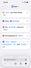
Until now, my biggest use of it in Aviation is to (with one tap) put my phone into “GA Flight Mode’ which reduces battery drain, launches ForeFlight, maxes screen brightness and volume, and a modified “do not disturb” that turns off texts, calls and notifications except from my wife and ForeFlight. Here’s a screenshot of that one as it’s really easy to recreate if anyone is interested.

I’ll send you a PM so I can get you the shortcut itself vs a screenshot
 

Attachments

  • IMG_2095.png
    IMG_2095.png
    1.2 MB · Views: 5
I don't think it would be very hard to come up with examples where the weighted average of a few data points gives you total garbage, even before feeding it through the ChatGPT human centipede.

Green dots in ForeFlight don't tell you a thing about the spaces in between the green dots.

Or, you might have two airports that are physically close to one another, but one has east winds and the other has west winds, due to the proximity of a body of water. Would your composite average those wind vectors together to show no wind?

Why not just go with the output of a point forecast? What problem are you trying to solve?
Understood and agree. Reasonably well educated and experienced in data modeling, applied statistics, etc.
It was a tinkering exercise. I know I can get the data through a lot of sources - and I do. I built both - one is just the METAR for the closest field, the other is the composite.

The most singular “solve for” is once I am in the cockpit, I don’t want to be scrolling, tapping, or finding things on my phone. I want to push my flight plan from ForeFlight, keep it running as a backup, and spend the rest of my time either eyes outside or on my PFD’s. Pushed data beats “searched for” data regarding the impact to cognitive distraction.
 
I think @dmspilot meant getting the ATIS airport info online.
You can’t get the ATIS online anywhere that I am aware of. You can call most airports with an ATIS to get the ATIS recording; which is useful if the winds are not coming in the usual direction and you want to see which runways they are using.
 
My airport has no METAR, nor any other weather source. I mentioned ATIS as the closest airport is a controlled field. I generally can’t pick up their ATIS on the ground, so I call and get it by phone - which is a bit of a PITA.

That’s what prompted me to build this.

Your solution is interesting, but I don't understand your impetus for it. Unless the nearby ATIS-airport is extremely rare, it has a METAR associated with it that you should be able to get with any EFB or weather app.

The ATIS itself is almost always the controller just reading the METAR and then adding any other pertinent information - information that usually isn't important if you're actually departing from a nearby field, like taxiway closures.

Now, if you don't have cell service where you are trying to get the METAR/ATIS, then that's one thing, but then how would you use your app anyway?

That's not to say I don't like your app idea, I do. But the reason you gave for starting down that path I don't understand.
 
Until now, my biggest use of it in Aviation is to (with one tap) put my phone into “GA Flight Mode’ which reduces battery drain, launches ForeFlight, maxes screen brightness and volume, and a modified “do not disturb” that turns off texts, calls and notifications except from my wife and ForeFlight
I have two for my EFBs. One for day flights; one for night flights. Other than the brightness setting, they are the same. They toggle WiFi and Bluetooth off and on (a recommendation I once heard to ensure good connections); set the volume and turn the orientation lock on. Finally, it pulls up the settings app so I can check the connections to the panel or other equipment. Since iPadOS 26's windowing, I've also been playing with loading the EFB and my chosen notepad app side by side, but since I use my iPad in portrait mode, it's not quite as good as it would be in landscape.
 
Last edited:
I have two for my EFBs. One for day flights; one for night flights. Other than the brightness setting, they are the same. They toggle WiFi and Bluetooth off and on (a recommendation I once heard to ensure good connections); set the volume and turn the orientation lock on. Finally, it pulls up the settings app so I can check the connections to the panel or other equipment. Since iPadOS 26's windowing, I've also been playing with loading the EFB and my chosen notepad app side by side, but since I use my iPad in portrait mode, it's not quite as good as it would be in landscape.
I like the night - I’ll be borrowing that one.

The one item that I have not figured out how to solve for is that I connect to my panel via Bluetooth and WiFi (BT for Garmin, WiFi for Dynon). Because of the WiFi connection, I get the “continue using WiFi or use cellular” message. I would love to have the shortcut tell it to use cellular for data - but I’ve not overcome that one yet. Any ideas?
 
Your solution is interesting, but I don't understand your impetus for it. Unless the nearby ATIS-airport is extremely rare, it has a METAR associated with it that you should be able to get with any EFB or weather app.

The ATIS itself is almost always the controller just reading the METAR and then adding any other pertinent information - information that usually isn't important if you're actually departing from a nearby field, like taxiway closures.

Now, if you don't have cell service where you are trying to get the METAR/ATIS, then that's one thing, but then how would you use your app anyway?

That's not to say I don't like your app idea, I do. But the reason you gave for starting down that path I don't understand.
Yeah - I like the ATIS because the airport in question is a HEAVY training airport so I like getting a little more insight on what they have going on. The two airports are 8 or so mi apart, and there can be conflicts. Most of the time - there is nothing of note, so the METAR is fine.

The original concept was to get the digital ATIS pushed to my phone - with the goal of eliminating fussing around with the phone at all once in the cockpit. I already have a routine that is designed to keep me out of the phone when flying.

I couldn’t get the ATIS concept to work, so then built it for the METAR….and then kept tinkering (hey, why not pull the other local METARS for a broader picture). I shared it really to highlight the potential of shortcuts as a workload reducer to help keep us focused, not that I think the particular application of it here is perfect.

In the end, I am planning to use the single METAR approach. I’ll keep tinkering with the composite and if I like the results, maybe I’ll incorporate that into my routine in the future. When I get out of the car, I pick up my phone and tap fly. When I look at it again in the cockpit - I have the current weather right on the screen, and my phone is configured for flight. No hunting, scrolling, or tapping. From then on, the phone is only a backup, and recording my flight track and logbook.

Mind you, by the time I get to the airport - I have already briefed the weather. Having played around with nearly every weather and aviation app, I use ForeFlight Windy. I’ve been active in GA for nearly 50 years now, so my formative flying years were all about watching flags, the windsock, movement of the trees, how smoke or steam are moving, finding a reference point to judge the ceilings…

Objective is to be even more eyes outside. By the time I yell “clear prop”, I really don’t want to look at my phone again unless I have an electrical failure.
 
I like the night - I’ll be borrowing that one.

The one item that I have not figured out how to solve for is that I connect to my panel via Bluetooth and WiFi (BT for Garmin, WiFi for Dynon). Because of the WiFi connection, I get the “continue using WiFi or use cellular” message. I would love to have the shortcut tell it to use cellular for data - but I’ve not overcome that one yet. Any ideas?
Since I've never owned a cellular iPad, no idea.
 
Your solution is interesting, but I don't understand your impetus for it. Unless the nearby ATIS-airport is extremely rare, it has a METAR associated with it that you should be able to get with any EFB or weather app.

The ATIS itself is almost always the controller just reading the METAR and then adding any other pertinent information - information that usually isn't important if you're actually departing from a nearby field, like taxiway closures.

Now, if you don't have cell service where you are trying to get the METAR/ATIS, then that's one thing, but then how would you use your app anyway?

That's not to say I don't like your app idea, I do. But the reason you gave for starting down that path I don't understand.
He's not really getting ATIS. The routine picks up METARs from aviationweather.gov. (I've heard more than one pilot say they are getting the "ATIS" while listening to an AWOS, so I tend to discount that terminology error).

Although I wouldn't use it for this purpose, the part I find most interesting is the use of ChatGPT to take the reports and create an area picture.
 
Why do you call it by phone when you can just get it online?
I was at S37 last weekend, waiting for some scud to burn off. No on-field wx. The nearest METAR data (KLNS) in ForeFlight were 45 minutes old and were showing MVFR, but calling up the ASOS on the phone got me a more current ceiling.
 
Back
Top