WDD
Final Approach
- Joined
- Oct 16, 2019
- Messages
- 5,339
- Location
- Atlanta / KRYY
- Display Name
Display name:
Vintage Snazzy (so my adult children say)
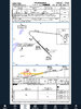
Studying for the written. The test prep says the missed for ILS is 4.6 miles from the outer marker, which is at the runway threshold. BUT the dashed line bending up tells me that is the missed point, which is .5 from the runway threshold. What am I missing?


")