
There's a VAS Aviation video that has it.Weird, still no Live ATC recording. I wonder what they are hiding?
Here:

There's a VAS Aviation video that has it.Weird, still no Live ATC recording. I wonder what they are hiding?
Doesn't the pic of the tire show a mark that was probably it swiping the trailer and rolling it over?
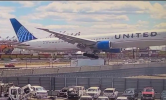
Shocking video shows United jet hit truck on NJ Turnpike in wild Newark landing
The plane also hit a light pole on its approach to Newark Airport Sunday.www.nbcnewyork.com
Pics of damage to the plane and truck. No way did the planes tire hit the truck.
That's so crazy. I've seen this happen once in real life. I was a student pilot and someone who sounded very old and who should have hung up his wings took out a landing light and dipped out without acknowledging what had happened. It's hard to imagine something similar with two people on the flight deck who have had a medical a maximum of 12 months previously.It's likely unremarkable. Neither the UA pilots nor ATC seemed to have noticed the mishap when it occurred. Makes for boring youtube video creation.

Thank youThere's a VAS Aviation video that has it.
Here:
It seems to be there.Weird, still no Live ATC recording. I wonder what they are hiding?
Got it. I'm used to seeing it out within hours of the incident, not the next day
huh?Shocking video shows United jet hit truck on NJ Turnpike in wild Newark landing
The plane also hit a light pole on its approach to Newark Airport Sunday.
Pics of damage to the plane and truck. No way did the planes tire hit the truck.
I'm hearing rumors that it might be a fake image?


Well, they gotta keep in practice to fake the next NASA mission.If false, then they did an excellent job of lining up the tires and that last frame of truck GoPro.

I don't know what you mean. LiveATC archives everything it records, and it's always available there as soon as it's recorded. It would be pretty obvious if they removed a recording from the archive to hide something. I assume that no one grabbed it and posted it here just because there's nothing on it.Got it. I'm used to seeing it out within hours of the incident, not the next day
Well, "fruit" is a botanical term and "vegetable" isn't, so they're actually orthogonal.To get pedantic.
And go to genus and epithet (species).
Truck is global (eg. vegetable).
Specifically it was a tractor-trailer. (Which, just as a fruit is a vegetable, is a type of truck.)
The tire (or tyre if you like superfluous "u"s), attached to a wheel, struck the trailer of a tractor-trailer.


There is no glideslope. No precision approach to that runway.Bottom line, at the moment it hit the truck, how much higher should the plane have been to be not more than one dot low on the glideslope?

There is a PAPI, however.There is no glideslope. No precision approach to that runway.
True, but...My back-of-a-napkin math says the crew should have been seeing all red on the PAPI.


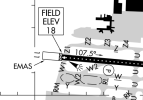
The approach comes from the right sideFrom the notes for runway 29:
4-light PAPI on right (3.00 degrees glide path)
PAPI UNUSBL 4 DEGS LEFT OF CNTRLN.
Depending on their alignment, I wonder if they didn't even see it for a portion of the approach.
I really don't think that the problem was that they didn't know that they were low.My back-of-a-napkin math says the crew should have been seeing all red on the PAPI.


I haven't seen an effort to crucify, but they did hit two things on the ground while they were OUTSIDE the airport fence. There's no real excuse.Be not in a race to crucify!


No. It leaves "on path." That's your option.The problem is a 300,000 lb aircraft on a somewhat obstructed 6,700 foot runway. You don't want to be even a schosh high. That leaves "on path" or low.
I once saw a pilot in a C130 make a tactical short field landing. He had ~3600 avaialbe. You have to be pretty darned precise under pressure to make it work. He was at the right energy and 3 our of 4 low. They nailed it.
Look up LRRS Sparrevohn AK. There was no fuel available so he wasn't "light". 4,200 ft, but on that day only 3600 was available.
I am not THAT good.
We once looked at a home in a nearby airpark. Runway was 2000 feet, obstructed. I did a perfect short field approach and landing (PA-34), at 700 undergross and had ~300 feet left. I said "we'll look at the house but I'm not buying". I could have a bad day any day.
These crews don't have much of a choice and when they do the math they are not permitted to count the reversers in the calculation. For all we know a system may have been inop. leaving few options to the crew. So the peanut gallery needs to back off and await the NTSB. We can SAY they should have declined for a longer runway but we don't know their fuel situation either.
Be not in a race to crucify!


 theaviationhub.co.uk
For some reason, I thought most of the USA airliners had radar altimeters.
1. Is this true, or dated information?
2. If true, are they normally used?
Tim

Um, no, it struck the tractor. It punched a hole in the cab and broke the windshield.To get pedantic.
And go to genus and epithet (species).
Truck is global (eg. vegetable).
Specifically it was a tractor-trailer. (Which, just as a fruit is a vegetable, is a type of truck.)
The tire (or tyre if you like superfluous "u"s), attached to a wheel, struck the trailer of a tractor-trailer.

Just curious, only because my high school geometry fails me, are you calculating the 3% path of the PAPI from its location 1,000 feet from the threshold, 1630 feet from the highway?The geometry is interesting.
TCH is 60'. The southbound lane of I-95 is ~630' from the threshold. The PAPI is 3.00°. That puts the center of the PAPI glidepath about 90' above I-95 but that's to the pilot's eye-level.
Subtract the 15'-20' that the gear hang under the pilot's eye-level, add the height of the light pole, and you might be down to 50' (20' pole) to 30' (40' pole) of clearance and that's when you're on the center of the PAPI glidepath.
Depending on the height of the pole, they may have been only 30' to 50' below the center of the PAPI GP. I did not know that the margin was so small.
He's doing it from the PAPI location. 1630' away puts a 3° glide path at 85'Just curious, only because my high school geometry fails me, are you calculating the 3% path of the PAPI from its location 1,000 feet from the threshold, 1630 feet from the highway?
He's doing it from the PAPI location. 1630' away puts a 3° glide path at 85'
Then some of the tires, attached to the wheels, on the left main gear ...... struck the tractor. (And) punched a hole in the cab and broke the windshield.
After the 1900 Hurricaine, the city of Galveston Texas undertook a monumental "grade-raising" project to protect the city from storm surges. Over 8 years (from 1903 to 1911) 2,000+ buildings were raised 8 to 16 feet by hand-turned jack screws. While on stilts, engineers pumped millions of cubic yards of slurry, dredged from the harbor, into the space beneath. Residents continued living in their elevated homes, using high wooden catwalks to navigate "the city of mud" until the sand dried and new foundations were built. - Just sayin'I figured as much, but without doing the math myself. All red on a PAPI or VGSI should be about 2.5% if someone wanted to figure out that math.
Standard runway safety area for a commercial service runway is 1,000 feet from the threshold, so even with a 630 displaced threshold EWR must have a mod to standards to allow that shortened area. That mod may get a second look.
As been stated, 85' pilot eye level at the highway or fence depending on the aircraft can leave the gear as low as 50-60 feet if on glidepath. Clearly there shouldn't be anything on the highway that tall, but doesn't leave a lot of tolerance for error. Honestly amazing this hasn't happened already.
Given the recent spate of accidents and closecalls and the renewed focus on safety, I would not be surprised to see this runway get further displaced.
After the 1900 Hurricaine, the city of Galveston Texas undertook a monumental "grade-raising" project to protect the city from storm surges. Over 8 years (from 1903 to 1911) 2,000+ buildings were raised 8 to 16 feet by hand-turned jack screws. While on stilts, engineers pumped millions of cubic yards of slurry, dredged from the harbor, into the space beneath. Residents continued living in their elevated homes, high wooden catwalks to navigate "the city of mud" until the sand dried and new foundations were built. - Just sayin'
Yes. They are used to determine Decision Altitude and Alert Height on lower-than-standard ILS minimums. i.e. CAT II and CAT III approaches. They are not helpful at ~100' on a visual landing.For some reason, I thought most of the USA airliners had radar altimeters.
1. Is this true, or dated information?
2. If true, are they normally used?
Tim
Just curious, only because my high school geometry fails me, are you calculating the 3% path of the PAPI from its location 1,000 feet from the threshold, 1630 feet from the highway?
