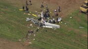
SR22T down outside Raleigh

Tail number released on FB. Family of 4, perished.
 
Interesting it looks like he hand flew the flight whereas previous flights a/p was engaged. Also odd was was altitude was solid at 11,700 and just stopped. Ain't hitting terrain at 11,700.
 
Fragmented. Personally I can't pick out "four corners". Near Sanford Raleigh Executive Airport.
1751970623159.png
 
What a tragedy. It’s odd the tracking just stops at 11700 ft and a couple MPH. Like it broke apart at that moment or lost all power. And then no chute deployment? Hate to speculate but it’s almost like they hit something.
 
?inflight breakup?
After looking at the photo more closely, it appears that I can see the empennage, upside down, behind the wings.
A lot of questions here; I don't know if one can "break" the tail and have it hang uselessly by threads as you drop; that would be a good time to pull CAPS, if you can reconcile the situation in your mind.
 
Something doesn’t add up here. Reports say they were coming home to Sanford but why would they still be at 11,000 feet 15 miles from the runway?
 
What a tragedy. It’s odd the tracking just stops at 11700 ft and a couple MPH. Like it broke apart at that moment or lost all power. And then no chute deployment? Hate to speculate but it’s almost like they hit something.
Or shed a prop blade and the engine departed...however, that mass ahead of the main wreckage might be the engine. Very unusual.
 
The ADS-B track ends abruptly just NE of Daytona Beach (2 hours before the crash), but it remained tracked by multilateration until about 11.5nm SE of TTA. The only small aberration is that the groundspeed dropped from 184 knots to 159 knots over the last two pings (while still level at ~11,700).

The derived flightpath makes it look like it might have been hand flown, at least in terms of lateral navigation.

But if TTA was the destination, being at 11,000+ feet at nearly 12nm out is odd.

The weather was clear and a million with only very small, isolated buildups well to the southeast of the crash site.

Obligatory METAR:
KTTA 071725Z AUTO 25007KT 10SM CLR 32/22 A3003 RMK AO2 T03200224
 
What a tragedy. It’s odd the tracking just stops at 11700 ft and a couple MPH. Like it broke apart at that moment or lost all power. And then no chute deployment? Hate to speculate but it’s almost like they hit something.
Hypoxia and ran out of gas? Might as well start the speculation....
 
The ADS-B track ends abruptly just NE of Daytona Beach (2 hours before the crash), but it remained tracked by multilateration until about 11.5nm SE of TTA. The only small aberration is that the groundspeed dropped from 184 knots to 159 knots over the last two pings (while still level at ~11,700).

The derived flightpath makes it look like it might have been hand flown, at least in terms of lateral navigation.

But if TTA was the destination, being at 11,000+ feet at nearly 12nm out is odd.

The weather was clear and a million with only very small, isolated buildups well to the southeast of the crash site.

Obligatory METAR:
KTTA 071725Z AUTO 25007KT 10SM CLR 32/22 A3003 RMK AO2 T03200224

Flight aware has a better track log
 
Flight aware has a better track log
That’s what I used once I saw the ADS-B stop near DAB.

Also, the crash site seems to be about 4.5nm short of TTA, along nearly the same track as the final ping.
 
The fact that altitude was being perfectly maintained and course was not seems a little weird. No one can hand fly as level as the ADSB tracks reported, so it must be AP, right? But the course jiggles all over the place and, even if he was in heading mode instead of direct to a waypoint, would have required dozens of small AP adjustments to accomplish. So he must have been hand flying, right?

It will be interesting to see how those two data points eventually gets reconciled, but it seems like there must be a clue there.
 
Hypoxia would make sense. 4 people on board you would think someone would have pulled the chute if there was trouble. My wife knows how to pull the handle if I can’t..I wonder when the last radio contact was?
 
I bet I’d like some heat for a family of 4 at 11.5k
CO2
It doesn’t take a lot of CO to be toxic and the mechanism to which it becomes incapacitating vs CO2 is a lot different.

Not that I’m jumping on that as a speculative cause - it’s all open. I’d just suspect CO more than CO2, all things being equal.
 
I bet I’d like some heat for a family of 4 at 11.5k
CO2
Use the ai machine to tell you what the toxicity is of co vs co2.

Co binds to the hemoglobin and is produced by incomplete combustion.

Co2 is more from respiration and not toxic at normal levels.
 
I still think there's something odd with the airplane/flight track throughout the duration nof flight that leads me away from co
 
Several things going on with this flight we gotta sort out.

Something happened with the avionics/electrical system that ADS-B out quit. Then it was just Mode-C, so the transponder appears to be working.
Was the GPS working? ADS-B needs this.
Was the pilot aware this "event" took place? Were there radio calls where he advised he was continuing vs landing to try and address? He departed VFR1200 then picked up a squawk so he was talking and would have VFR flight following.

Why did they stay high so close to the airport? Pilot incapacitation of some kind? Carbon monoxide poisoning? Smoke flooded the cabin?
Was there some kind of a fire in the plane or engine bay that burned wiring and/or part of the electrical system? I don't know the Cirris wiring diagram to see what is powered from which electrical bus to know if a limited fire could have caused equipment failures.

Were there ATC calls not responded to? It will be interesting to see what Centers have on tape for this aircraft. At what point did he go NORDO, if at all?

Fuel receipts - how much gas did he have when he left. With his entire family I would have thought he'd be full. He was going home. No chute pull makes one wonder why if the pilot knew there was an issue(s). Slow the plane, start a descent, and pull the chute.

Extremely sad situation.
 
if it was CO - then they were probably all out. And if thats the case - that plane probably would have flown to Maryland or sfurther north or omething. I believe they are from Sanford NC, and they didnt end up far from it either. 2.30 hour flight. Most cirrus would easily do 4+ hours. So not sure if the fuel situation would have been that close to empty based on where they ended up vs their intended destination. As in with CO poisoning, they would have kept flying until they were out of fuel.
The flight path looked to be under some semblance of manual control until it suddenly disappeared. It didn’t seem to be holding steady enough to be on autopilot. But if they were all out, I’d have expected a spiral of some sort. I mean, could be a heading hold but with very variable winds aloft. The lack of ads-b datapoints beyond the final path indicated when they were still being pinged by radar, presumably under ZDC control, makes it tough to discern much.

I checked TTA CTAF archives, nothing from 56M (though they were extremely busy). Nothing on RDU approach. Still looking for something from ZDC.
 
I would not expect hypoxia to be high on the list of suspects. This thing didnt just fall out the sky from 11,700. ADSB was lost near Daytona. It appears to be hand flown nearly to the destination when previous flights were autopilot. I would expect there to be some sort of avionics failure which would make the reported altitude suspect.

I thought I remember a thread recently where some autopilots put out the altitude its set at and thats how some sources get data?
 
Something happened with the avionics/electrical system that ADS-B out quit. Then it was just Mode-C, so the transponder appears to be working.
Was the GPS working? ADS-B needs this.
Was the pilot aware this "event" took place? Were there radio calls where he advised he was continuing vs landing to try and address? He departed VFR1200 then picked up a squawk so he was talking and would have VFR flight following.
Maybe someone can help my understanding, but for Flightaware’s tracking purposes, does it cease tracking when the airplane’s ADS-B isn’t being picked up *and* ATC is not tracking the aircraft? Like, if I were to squawk 1200 and have no ADS-B, do I drop off the website? Versus squawking a discrete code under flight following?

The reason I ask is because my supposition in this case is they cancelled flight following as they approached TTA and ZDC gave them 1200 and CTAF, at which point (along with the lacks of ADS-B) the data sent to Flightaware ceased. Or does it remain active as long as the transponder is working, even if it’s not tagged up on a discrete code?
 
I would not expect hypoxia to be high on the list of suspects. This thing didnt just fall out the sky from 11,700. ADSB was lost near Daytona. It appears to be hand flown nearly to the destination when previous flights were autopilot. I would expect there to be some sort of avionics failure which would make the reported altitude suspect.

I thought I remember a thread recently where some autopilots put out the altitude it’s set at and thats how some sources get data?
The ADS-B out will put out certain nav modes and selections in separate data fields, but my understanding is that this does not substitute for the reported actual altitude. Unless maybe there’s an issue with the transponder or altitude encoding system as well. The ADS-B prior to disappearing and the reported MLAT altitude for the remainder of the track were roughly the same. But this also goes back to the question posed in my last post.
 
Here is the Flightaware Track Log

Two points of interest to me.

At 10:30, Flightaware stops tracking it on ADS-B and is relying on ATC radar for position.

The aircraft maintains 11,700 altitude to the end, but the last few hits the airspeed starts to rapidly decrease. Without other data, this does have the hallmarks of an incapacitation event that continued until fuel exhaustion.
Which goes back to the question - does the presence of the Flightaware track log and absence of ADS-B data mean it was tagged up? And if so, that means they should have been talking to somebody, which presumably (but not definitely) means that there should have been more news to that end.
 
Which goes back to the question - does the presence of the Flightaware track log and absence of ADS-B data mean it was tagged up? And if so, that means they should have been talking to somebody, which presumably (but not definitely) means that there should have been more news to that end.

The last ADS-B hit they did have a squawk code of 0725, so they were talking to someone at that point. I don't think anything can be inferred from the presence of the Flightaware track log and whether or not they continued to have flight following. I would say they were not filed IFR since FA does not have a destination from a flight plan in their system.

The oddity is why they lost ADS-B early in the flight, and how they maintained (if it is not a tracking quirk) 11,700 so precisely, but the aircraft seemed to have slow oscillations left and right. I suppose you could have altitude hold engaged without steering, but why?
 
Something seems amiss with this one.

The guy flies a lot. Privately owned and has 37 flights in the last 3 months according to flightAware. So I doubt proficiency is any part of the explanation (flying proficiency or fuel planning). He does quite a bit of long XC. Also, he's got some IFR filed plans in there too so he's got that skill set (plus wx that day was fine).

Based on his prior months flying history, his normal flight tracks look much more precise (like: autopilot precise). That makes me think he wasn't using AP for this flight; and his flight track (if it's to be trusted w/o more accurate ADS-B data) looks like less direct flying than his normal pattern.

Eyeballing the the FlightAware track he was 15-20 miles out over the Atlantic at times. With the family onboard, I would hope he'd be on the radio with ATC/FF during that time. I know I would be... I wonder if that reveals anything about his state.

But given the abrupt cutout of his track, I'd guess the potential culprits are:
(1) inflight fire where he kills the electrical system and tries to get it on the ground quickly (would probably skip the chute in that case, right? You just want to get down fast);
(2) collision;
(3) bad ADM of some kind

My guess is #1, but it's a total wild-ass-guess.

Sad when you see a family go down. RIP.
 
The flight path looked to be under some semblance of manual control until it suddenly disappeared. It didn’t seem to be holding steady enough to be on autopilot. But if they were all out, I’d have expected a spiral of some sort. I mean, could be a heading hold but with very variable winds aloft. The lack of ads-b datapoints beyond the final path indicated when they were still being pinged by radar, presumably under ZDC control, makes it tough to discern much.

I checked TTA CTAF archives, nothing from 56M (though they were extremely busy). Nothing on RDU approach. Still looking for something from ZDC.
I have no idea what happened in this flight. I think that the 4 people were not conscious. I base that on the chute handle not being pulled. Depending on when the people quit responding they may have been unable to switch tanks. There are a few situations where the AP will drop from NAV mode to Roll mode and still continue altitude hold. One is loss of GPS. Coincidentally loss of GPS integrity or signal will stop ADSB out. Another is fuel imbalance or aileron trim out of whack and overpowering the servos. If it gets bad enough the AP will kick off, but it will attempt to maintain wings level as long as possible.
 
Here is the Flightaware Track Log

Two points of interest to me.

At 10:30, Flightaware stops tracking it on ADS-B and is relying on ATC radar for position.

The aircraft maintains 11,700 altitude to the end, but the last few hits the airspeed starts to rapidly decrease. Without other data, this does have the hallmarks of an incapacitation event that continued until fuel exhaustion.
There are 46 gal per tank. The Turbos can run from 14-18ish gal/hr in cruise depending on how one chooses to set the power. If they never reduced the mixture once reaching cruise altitude it could be almost double that. Someone would have to be conscious to change the squawk code. It seems there wasn’t anyone conscious to pull the handle but were able to switch the transponder code. If the fuel tanks didn’t get switched or the mixture remained full rich the time to fuel exhaustion can vary considerably. If the Remote Data Module (RDM) is recovered they will know a lot about what happened. This was a G3 so Garmin Perspective (G1000) with GFC700.
 
I suppose you could have altitude hold engaged without steering, but why?
Maybe to let a kid fly and only worry about steering?

not seeing evidence of fire, so maybe it did run out of fuel.
 
Maybe to let a kid fly and only worry about steering?

not seeing evidence of fire, so maybe it did run out of fuel.
As a thought exercise - you’re 11nm from the field at over 11,000’ above the airport elevation. Lack of chute-pull SOP aside, how would someone end up 4 miles short of the field from that point, even if the engine was no longer working?

A quick check makes it sound like an 8:1 glide ratio in the SR22T - that should have theoretically gotten him halfway to RDU from that altitude, again chute (or lack thereof) notwithstanding. Winds aloft were out of the west at 10-15kts at 12,000, backing slightly to west-southwest and lighter toward the ground.
 
Back
Top