[NA]7/4/25 Central TX flooding

Let'sgoflying!

Touchdown! Greaser!
Joined
Feb 23, 2005
Messages
21,872
Location
west Texas
Display Name
Dave Taylor
Home Airfield
KMRF
Many fatalities
Rivers engorged
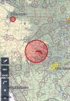
Huge TFR
14 helos in rescue service
Many trapped on high ground
Others missing

IMG_9211.jpeg
 
This is my neck of the woods. Been busy all day; there’s going to be some tragic stories come out in the next few days, if not tonight.
 
Got 20 missing out of Camp Mystic, and all appear to be kids at this time. It's worse than the 1987 Pot O' Gold Camp disaster... Been on the Blanco River when it went up a few feet in several hours and that was nothing like this. When the Hunt gauge station went offline at 4:30 am, it was showing almost 30 feet above flood stage and a flow rate of over 120,000 CFS. Normal flow at the gauge runs about 535 CFS.....
 
Question for anyone local: what caused this? Seems like little to no warning, why would that happen?
 
Question for anyone local: what caused this? Seems like little to no warning, why would that happen?

Weather. Overnight essentially a tropical storm developed (low pressure system) inland, fed by both Pacific and Gulf moisture and camped out, dropping six months of rain in 10 hours. Flash flooding continues overnight tonight, 27’ above normal expected. Upstream it was 34’ crest this morning. More tropical rain expected thru noon tomorrow.

There were broad flood warnings across the CWA (77-counties) yest,erday afternoon, but nobody, to include NWS expected a foot to fall in the main drainage at the headwaters of the Guadalupe.

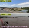
I spent most of the day supporting evac operations downstream and we got washed out about noon today. Not my photos below, but this is ~ forty miles down stream in the are I was working.

177c17feb4ee1028f4c0bfc3f91dbcf7.jpg

The low vegetation on that little peninsula is ~ 4ft, the trees on the bank ~60ft and taller.

41d71e70e0e98e2d0b49e0a316776689.jpg


ETA: NWS says it’s possible we can get another 3+” in the next 24 hours. That’ll be damn near a year’s rainfall in less than 48hrs.
 
Last edited:
I was reading some of the news stories earlier tonight. This is a bad one.

This pic is of two of the kids pulled out.

IMG_9062.jpeg
 
Going north-south, between Fredericksburg and Bandera, and east-west, Blanco and Rock Springs, you have the Guadalupe, Blanco, Colorado and the Pedernales. All are in flood stage due to so much rain upstream. Normally, all are slow flowing, and it helps make the area popular for big camps. There's probably a couple dozen kids and church camps spread out in and around the rivers.
 
Going north-south, between Fredericksburg and Bandera, and east-west, Blanco and Rock Springs, you have the Guadalupe, Blanco, Colorado and the Pedernales.…

Frio flooded too. Won’t know about all the missing until people don’t return on Sunday/Monday.
 
Looking rough again this morning. I’m just east of the flood warning but I expect to be included in it soon. We will probably help move cattle today.

The tragic loss of life is always tough. Hearing the stories of this camp and how they’re starting to find them, and it’s not good news. I can’t begin to imagine the heartbreak of losing a child. As we celebrated the 4th last night, my daughters got more hugs than usual.
 
Frio flooded too. Won’t know about all the missing until people don’t return on Sunday/Monday.
Thanks for being there and helping out. I’m in Taylor. If there’s anything I can do, let me know and some friends and I will head that way.
 
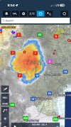
According to NOAA, a combination of a mid level vortex spawned by storms over the Mexican plateau slowing a very localized, and heavy thunderstorm. From looking at the radar, it appears that the thunderstorm complex is almost stationary and has been for a couple of days now.

Probably one of the best youtubes for weather events, is Max Velocity....especially for north and central Texas.
 
IMG_7868.jpeg
Here we go. Watching the creek by the airport closely. Went out and looked at the San Gabriel River and its rising quickly.
 
Watch carefully Jack...Brushy Creek at Kenney Fort Blvd is up two feet and climbing since 4:30 this morning and flow has at least trippled since then. The San Gabriel at Lake Georgetown is up over 6 feet in the same period and no flow data is available. The gauge at Georgetown South Fork has been offline since last evening, so no data there.
 
Oh my god. Prayers to all. This is horrifying.
 
Watch carefully Jack...Brushy Creek at Kenney Fort Blvd is up two feet and climbing since 4:30 this morning and flow has at least trippled since then. The San Gabriel at Lake Georgetown is up over 6 feet in the same period and no flow data is available. The gauge at Georgetown South Fork has been offline since last evening, so no data there.
I follow Meteorologist Avery Tomasco, best one we’ve had around here in years. He just showed a video of Georgetown. Blue Hole is under water and it’s headed our way. Going to be a long day.
Georgetown Flooding
 
Jack: Also look up Max Velocity on youtube...He's from the Argyle area and has been more accurate than most meteorologist around the north and central Texas area for years. Got an uncanny ability to see how things are going to play out long before the models make predictions. If NOAA doesn't grab him when he graduates, they are nuts...
 
River crested near our place at 41’ about last night about 10p Here’s the nearest low water crossing from a couple hours ago. Yellow line is the road; it drops down to the river and then climbs back up. Redline is the river’s normal banks.

The river’s normally 35’ wide at the crossing and the crossing is about 6’ above normal level. You can easily kayak under it. It’s 1/4mi or so across now and i’d guess the bridge is under 25’ of water. I was ankle deep in silt when taking picture.


2c80f308ee0f1940cef552d130f0ca0f.jpg
 
Absolutely terrible. Stay safe everyone.
 
The coverage is absolutely gut wrenching. Praying for the families. I can't even imagine.

It’s going to get worse. There’s a bunch of RV campgrounds along the rivers mentioned above. Nobody’s real sure how many folks were at each one and comms/access are just being opened up.

It’s a pretty penny, but I’m looking at buying a DJI first responder drone or two and working w/an AF mate of mine that developed a mesh net comms/data solution to bridge the gap between first responder comms and lower priority stuff.

I’ve got an idea that’s workable based on past experience and he’a got the connections.
 
I keep coming to this thread hoping to see something good. But knowing sadness is very likely.
 
It’s a pretty penny, but I’m looking at buying a DJI first responder drone or two and working w/an AF mate of mine that developed a mesh net comms/data solution to bridge the gap between first responder comms and lower priority stuff.

Perhaps a balloon (tethered) would be better, more persistent and higher payload. Just something to think about
 
[the opposing view]

Unless you've been trained to work with, and integrate into, the the local & state emergency response program, you'll just be in the way. There are TFRs all over the place, hence your drones/balloons will be illegal and likely you'll be in deep trouble if they find you.

Colorado had this problem during the fires a couple years ago. Didn't matter if they were "good intentions" or "vicarious look what I can do!" each time a drone was in the TFR, the drop planes had to clear the area. And the helicopters. And the legit drones.

[end the opposing view]

As of this timestamp,

"Kerrville city manager Dalton Rice said people have been flying personal drones in Kerr County, posing a danger to rescue aircraft as search operations continue. “We need to keep these drones, these personal drones out of the sky," Rice said. "We have drones and assets flying, we want to continue to do that.”"

Here's a list of verified organizations that are accepting help.


or the tiny url version:

 
Last edited:
[the opposing view]

Unless you've been trained to work with, and integrate into, the the local & state emergency response program, …
That’s exactly the path we’re exploring. There’s 28 FEMA US&R teams as an initial target market; fast follow to other formalized Search & Rescue orgs, state EM depts down to the VFDs.

I’ve done DSCA work professionally before and was previously NIMS 100, 200, and 300 trained. We’re looking at pivoting some capabilities for specific use cases.
 
Last edited:
The TFRs have been evolving. Friday it was a single 25nm TFR to 3000AGL. Yesterday it shrunk to 5NM around Camp Mystic.

Sometime today, they added a corridor the generally follows the Guadalupe from its headwaters to Canyon Lake. These TFRs appear to be controlled by TXANG and range from SFC-FL180 depending on TFR.

55dbd0fe65be776652a50e52dae9c06f.jpg


More aerial assets are a good thing at this stage. I’m hedging that tomorrow’s the last day of rains; there’s really four geographically (and chronologically) separate areas with catastrophic flooding from different rain events. The Hill Country will get more rain tonight.

We’ve needed it, but not to this degree.
 
[the opposing view]

Unless you've been trained to work with, and integrate into, the the local & state emergency response program, you'll just be in the way. There are TFRs all over the place, hence your drones/balloons will be illegal and likely you'll be in deep trouble if they find you.

Colorado had this problem during the fires a couple years ago. Didn't matter if they were "good intentions" or "vicarious look what I can do!" each time a drone was in the TFR, the drop planes had to clear the area. And the helicopters. And the legit drones.

[end the opposing view]

As of this timestamp,

"Kerrville city manager Dalton Rice said people have been flying personal drones in Kerr County, posing a danger to rescue aircraft as search operations continue. “We need to keep these drones, these personal drones out of the sky," Rice said. "We have drones and assets flying, we want to continue to do that.”"

Here's a list of verified organizations that are accepting help.


or the tiny url version:

These people are why drone operators get a bad rap. Stupid.
 
We’ve needed it, but not to this degree.
Unfortunately (as you know), that’s the pattern here: every decade-long drought gets resolved with a week of terrible flooding in July. 2002 and 2008 come to mind. Even with those this one stands out.
 
Unfortunately (as you know), that’s the pattern here: every decade-long drought gets resolved with a week of terrible flooding in July. 2002 and 2008 come to mind. Even with those this one stands out.

Yeah. The 1981 Memorial Day floods were the first I can recall experiencing; this is definitely a stand-out event even though there was a serious (13 fatality) flash flood in the San Antonio area two or three weeks ago while we were in Canada. That one was more a result of poor urban planning over thirty years (let’s drain everything across a major thoroughfare).
 
[the opposing view]

Unless you've been trained to work with, and integrate into, the the local & state emergency response program, you'll just be in the way. There are TFRs all over the place, hence your drones/balloons will be illegal and likely you'll be in deep trouble if they find you.

...

my assumption was that the system(s) would be offered for use and not just thrust upon them.
 
I got on this group’s mailing list during the Helene recovery and have been getting emails from them now, here is the link and what they are asking for.


Attachments

  • IMG_4085.jpeg
    IMG_4085.jpeg
    252.8 KB · Views: 10
  • IMG_4086.jpeg
    IMG_4086.jpeg
    148.9 KB · Views: 10
Yeah. The 1981 Memorial Day floods were the first I can recall experiencing; this is definitely a stand-out event even though there was a serious (13 fatality) flash flood in the San Antonio area two or three weeks ago while we were in Canada. That one was more a result of poor urban planning over thirty years (let’s drain everything across a major thoroughfare).
I was with my mom out in that weather for one of those really bad flash floods in San Antonio. Pretty crazy, but yeah, this is not all that weird or actually unusual in the grand scheme of things, and the last 10 years of growth in Texas has probably exacerbated the situation with more habitation and resultant drain-off vs absorption / retention of water.
 
Sometime today, they added a corridor the generally follows the Guadalupe from its headwaters to Canyon Lake. These TFRs appear to be controlled by TXANG and range from SFC-FL180 depending on TFR.

According to the governor’s press conference yesterday, the TFR up to 18K is for ANG MQ–9 support out of EFD.
 
Back
Top