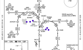
KAEG ILS RW 22 question

SkyHog

Touchdown! Greaser!
Joined
Feb 23, 2005
Messages
18,510
Location
Middle of nowhere Texas
Display Name
Everything Offends Me
Home Airfield
KLUD
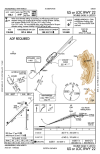
So it's 2026. At the top of the plate for the ILS 22 at KAEG is the "ADF Required." I know GPS can substitute for NDBs enroute but according to AIM 1-2-3, if it's being used to identify portions of the final approach segment the NDB must be operational and the plane must have the equipment to tune and identify it (I. E., an ADF).

There's nothing on this chart that really indicates why ADF would be required, so I can't tell if I can use GPS in lieu of ADF... Any thoughts?

1787925510891.png
 
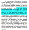
Well... old school says that "Required" on the plan view means needed to join the approach from the enroute environment. Is there some reason to not use the intercession of the ABQ transition and the LOC as an IAF?

But, in any event, it's certainly not for lateral guidance on the FAS, so substitution is just fine.
 
The ABQ radial is not designated an intersection at the LOM. Without doing the math, the angle does seem pretty acute - there is a limit for what's called "fix displacement error" and that may have been exceeded here. So ADF is required to get from ABQ to the LOM, switching nav sources halfway or so.

Also note that ADF is required for the missed approach.

But AIM 1-2-3 allows you to use GPS in lieu of these things, so practically you have no concerns.
 
I know GPS can substitute for NDBs enroute but according to AIM 1-2-3, if it's being used to identify portions of the final approach segment the NDB must be operational and the plane must have the equipment to tune and identify it (I. E., an ADF).
I just noticed you referred to this. You really have to read Notes 4 and 5 together. I did a few highlights:

4. Pilots may not substitute for the NAVAID (for example, a VOR or NDB) providing lateral guidance for the final approach segment. This restriction does not refer to instrument approach procedures with "or GPS" in the title when using GPS or WAAS. These allowances do not apply to procedures that are identified as not authorized (NA) without exception by a NOTAM, as other conditions may still exist and result in a procedure not being available. For example, these allowances do not apply to a procedure associated with an expired or unsatisfactory flight inspection, or is based upon a recently decommissioned NAVAID.​
​
5. Use of a suitable RNAV system as a means to navigate on the final approach segment of an instrument approach procedure based on a VOR, TACAN or NDB signal, is allowable. The underlying NAVAID must be operational and the NAVAID monitored for final segment course alignment.​

Both notes are referring to lateral guidance on the FAS. Note 5 was added several years ago to modify the strictness of note 4 and to authorize the already common practice of flying a VOR approach with GPS while monitoring the VOR CDI or, in modern PFDs, flying the approach in pink needles while have a bearing pointer tuned to the VOR.
 
Last edited:
I just noticed you referred to this. You really have to read Notes 4 and 5 together. I did a few highlights:

4. Pilots may not substitute for the NAVAID (for example, a VOR or NDB) providing lateral guidance for the final approach segment. This restriction does not refer to instrument approach procedures with "or GPS" in the title when using GPS or WAAS. These allowances do not apply to procedures that are identified as not authorized (NA) without exception by a NOTAM, as other conditions may still exist and result in a procedure not being available. For example, these allowances do not apply to a procedure associated with an expired or unsatisfactory flight inspection, or is based upon a recently decommissioned NAVAID.​
​
5. Use of a suitable RNAV system as a means to navigate on the final approach segment of an instrument approach procedure based on a VOR, TACAN or NDB signal, is allowable. The underlying NAVAID must be operational and the NAVAID monitored for final segment course alignment.​

Both notes are referring to lateral guidance on the FAS. Note 5 was added several years ago to modify the strictness of note 4 and to authorize the already common practice of flying a VOR approach with GPS while monitoring the VOR CDI or, in modern PFDs, flying the approach in pink needles while have a bearing pointer tuned to the VOR.
I saw this - 5 can't apply if you don't have ADF onboard though because you can't monitor the NAVAID - that's what's causing me to ask the question.

And I can't seem to tell from the chart if the NDB is providing lateral guidance for the final approach segment, as I'm not even sure what ADF would be used for here (one can, very easily, identify and navigate to DUDLE with a GPS or by using 11.5 DME off the ABQ 013 radial). I suppose, if someone did not have GPS or VOR, they could use ADF, but that seems an odd designation for requiring it.

So I'm wondering if I'm missing something where ADF is required that would possibly trip up #4 in the above if there's some lateral guidance on the final approach segment I'm missing.

Either way, this seems like a really easy update the FAA ought to make to get that "ADF REQUIRED" note off the chart...

Think about that for a moment. It's an ILS. Why would you be using an ADF to navigate ANY of the final segment? Answer - you're not. How do you tell? Look at the name of the procedure.

DUDLE is not designated as using the ABQ DME, so you cannot use it. It IS designated using the AE LOM, which is a combination outer marker and NDB. That is how you must identify DUDLE. If you could use DME or a crossing VOR radial, it would show the DME value in the name DUDLE, or would show "INT", respectively.

ILS, VOR, and NDB procedures assume you do not have GPS, hence on this one yes you do need ADF. Now, GPS is a suitable substitute, but the charts are not designed presuming you have it. Otherwise you'd have "or GPS required" on about every single procedure. There's no need for that, due to AIM 1-2-3.

There are ILS approaches which do require GPS, and GPS Required is specifically stated in the notes.
 
I saw this - 5 can't apply if you don't have ADF onboard though because you can't monitor the NAVAID - that's what's causing me to ask the question.

And I can't seem to tell from the chart if the NDB is providing lateral guidance for the final approach segment, as I'm not even sure what ADF would be used for here (one can, very easily, identify and navigate to DUDLE with a GPS or by using 11.5 DME off the ABQ 013 radial). I suppose, if someone did not have GPS or VOR, they could use ADF, but that seems an odd designation for requiring it.

So I'm wondering if I'm missing something where ADF is required that would possibly trip up #4 in the above if there's some lateral guidance on the final approach segment I'm missing.

Either way, this seems like a really easy update the FAA ought to make to get that "ADF REQUIRED" note off the chart...
“…And I can't seem to tell from the chart if the NDB is providing lateral guidance for the final approach segment…”

It’s the ILS OR LOC RWY 22 Approach. The Localizer provides lateral guidance for the final approach segment. It’s as simple as that. ADF Required still belongs on the Chart because it is required to identify the Missed Approach Fix. It is also needed to identify the Final Approach Fix if the Glideslope is unusable. GPS is an authorized substitution for those applications.
 
There's nothing on this chart that really indicates why ADF would be required, so I can't tell if I can use GPS in lieu of ADF... Any thoughts?
It is not a GPS approach, so there is no requirement for you to have a GPS. SO.... If you don't have a GPS to use in lieu of the ADF, how are you going to fly the PT or the Missed Approach???

For the ILS all would be good since you can get Vectors to Final, but you'd still need ATC to give you an alternate Missed. But there is no way you could fly the LOC since you can't identify DUDLE, the FAF. (Missed is moot at this point since you can't fly the LOC.)

ADDED: Thanks for @RussR comment. Totally forgot about a Marker Beacon receiver, which you could have to identify the FAF if you were flying the LOC only approach.
 
Last edited:
And I can't seem to tell from the chart if the NDB is providing lateral guidance for the final approach segment
It’s not. “Lateral” is left right guidance, as in a NDB approach. This is just a point in space.
 
It is not a GPS approach, so there is no requirement for you to have a GPS. SO.... If you don't have a GPS to use in lieu of the ADF, how are you going to fly the PT or the Missed Approach???

For the ILS all would be good since you can get Vectors to Final, but you'd still need ATC to give you an alternate Missed. But there is no way you could fly the LOC since you can't identify DUDLE, the FAF. (Missed is moot at this point since you can't fly the LOC.)
Well, to be clear, the FAF is an LOM, so even if you don't have an ADF, if you were getting vectors to final you could still identify the FAF using a marker beacon receiver.

Which, incidentally, you are assumed to have in the TERPS if you are flying an ILS or LOC, but that is no longer necessarily a fair assumption.

And lots of OM's are going away anyway.
 
Think about that for a moment. It's an ILS. Why would you be using an ADF to navigate ANY of the final segment? Answer - you're not. How do you tell? Look at the name of the procedure.

DUDLE is not designated as using the ABQ DME, so you cannot use it. It IS designated using the AE LOM, which is a combination outer marker and NDB. That is how you must identify DUDLE. If you could use DME or a crossing VOR radial, it would show the DME value in the name DUDLE, or would show "INT", respectively.

ILS, VOR, and NDB procedures assume you do not have GPS, hence on this one yes you do need ADF. Now, GPS is a suitable substitute, but the charts are not designed presuming you have it. Otherwise you'd have "or GPS required" on about every single procedure. There's no need for that, due to AIM 1-2-3.

There are ILS approaches which do require GPS, and GPS Required is specifically stated in the notes.
“…GPS is a suitable substitute, but the charts are not designed presuming you have it...”

It looks like someone had GPS on their mind when they drew this Chart. It has a CNF, Computer Navigation Fix. CFVLF around the outbound end of the HILPT. It has something else I don’t recall seeing before on other Charts. In addition to the inset with the Alternate Missed Apch Fix, it has it’s location depicted on the Planview.
CNFs are not navigable fixes, they are placed on some procedures that meet certain conditions for use with FMS coding of the procedures. Not really directly related to "GPS-required" on a ground-based procedure like this. And I believe the rules have gone back and forth as to whether they're even shown on the chart or not. The criteria in effect here is something like "if there is a PT or HILPT at the FAF and no IF, establish a CNF on the final approach course" although I'm not an expert on that stuff and it's been a while. See KCSM ILS 17R for another example of a HILPT at the FAF and a CNF.

You can likely find examples of this scenario where there is not a CNF shown, but there still may be one behind the scenes. Regardless, it doesn't create a requirement or expectation to have GPS.

As for the weird charting of AWASH out there, that is bizarre. AWASH is an en route fix on V187 and there are some rules about not charting radials at such fixes, but this one could certainly benefit from a relook. I'm not sure why it's shown in both places.
 
Well, to be clear, the FAF is an LOM,
Very true, sorry I missed adding that. If you're flying the LOC only approach and you have a Beacon receiver you're also good to go.

I'll make an edit.
 
CNFs are not navigable fixes, they are placed on some procedures that meet certain conditions for use with FMS coding of the procedures. Not really directly related to "GPS-required" on a ground-based procedure like this. And I believe the rules have gone back and forth as to whether they're even shown on the chart or not. The criteria in effect here is something like "if there is a PT or HILPT at the FAF and no IF, establish a CNF on the final approach course" although I'm not an expert on that stuff and it's been a while. See KCSM ILS 17R for another example of a HILPT at the FAF and a CNF.

You can likely find examples of this scenario where there is not a CNF shown, but there still may be one behind the scenes. Regardless, it doesn't create a requirement or expectation to have GPS.

As for the weird charting of AWASH out there, that is bizarre. AWASH is an en route fix on V187 and there are some rules about not charting radials at such fixes, but this one could certainly benefit from a relook. I'm not sure why it's shown in both places.
I’m not so sure CNF’s are not navigable. ATC will not give you clearances to or via them, they have no need to know they even exist. But I’m pretty sure they show up as Waypoint when you load an Approach in a GPS Navigator.@midlifeflyer , you do a lot of stuff with GPS simulators, could you navigate Direct to one?
As far as FMS goes, they have to be plugged into an underlying RNAV such as GPS, DME/DME, IRU for a CNF to show up. I doubt there any FMS’s out there that are not but it is possible, I think.

Well, of course you "can" go direct to them, just like you can go direct to the waypoint you created over your house. But they're not navigable in the sense that you don't put them in a flight plan, ATC won't clear you to them, etc. In most cases you won't even know they exist or what they're named, because they aren't on the chart. This is because the far more common use of CNFs are as RF center fixes for procedures with RF turns. These are not charted but they still exist. For example, on this RNAV (RNP) procedure, there are probably 6 of them, I'd guess positioned about where I put the blue dots. Sure, if you knew the name you could put it in, but there's no navigation reason to do so.

1788197838195.png
 
But I’m pretty sure they show up as Waypoint when you load an Approach in a GPS Navigator.@midlifeflyer , you do a lot of stuff with GPS simulators, could you navigate Direct to one?
Yes you can navigate to one by manually entering it into the flight plan- they are in the database. But no, they don't show up when you load an approach that has one.
 
Very true, sorry I missed adding that. If you're flying the LOC only approach and you have a Beacon receiver you're also good to go.

I'll make an edit.
Why if LOC only - if I have an ILS and can receive the the marker beacon (disregarding the unserviceable NOTAM, as this "ADF REQUIRED" not has been there long since before that NOTAM was published), why is ADF required for this approach? seems to me that you're using the ILS for directional navigation, and for the glideslope, and using the marker beacon for position support to identify the FAF.

It matters not - now I know I can use GPS for this based on re-reading several times AIM 1-2-3 and the AC, but now I'm curious why the note exists to begin with when there's multiple ways to identify the FAF without ADF...
 
...if I have an ILS and can receive the the marker beacon..., why is ADF required for this approach?

...I'm curious why the note exists to begin with when there's multiple ways to identify the FAF without ADF...
Correction: There are multiple ways to "substitute" for the ADF. If you don't have them, ADF is required because, as @RussR said in post #8, "ILS, VOR, and NDB procedures assume you do not have GPS, hence on this one yes you do need ADF."

Capiche? :)
 
Why if LOC only - if I have an ILS and can receive the the marker beacon (disregarding the unserviceable NOTAM, as this "ADF REQUIRED" not has been there long since before that NOTAM was published), why is ADF required for this approach? seems to me that you're using the ILS for directional navigation, and for the glideslope, and using the marker beacon for position support to identify the FAF.
ADF Required is for the OM if you're shooting the LOC and also needed for the Missed. But you could probably get an alternate Missed from ATC and as you said, a lot of people also have GPS, so it's a non issue.

As for the ILS, in theory the PFAF is the point where you aligned on the LOC and GS. So no need for the OM as you are on the Final Approach Segment once established. That's new since they created the PFAF 10-15 years ago.

And I should note it has been pointed out to me that the OM (or something in lieu of it) is listed as "part" of the ILS System. But I haven't seen anything that says you must use it if you're fly the ILS portion of the approach vs the LOC Only potion. Just that it is part of the approach and would be needed if you were fly the LOC Only.
 
And I should note it has been pointed out to me that the OM (or something in lieu of it) is listed as "part" of the ILS System. But I haven't seen anything that says you must use it if you're fly the ILS portion of the approach vs the LOC Only potion. Just that it is part of the approach and would be needed if you were fly the LOC Only.
It allows you to calibrate the GS for reasonability. If you're 200' above the crossing height of 7629' with the GS needle centered, you could be in the dirt at minimums on the ILS.
 
ADF Required is for the OM if you're shooting the LOC and also needed for the Missed. But you could probably get an alternate Missed from ATC and as you said, a lot of people also have GPS, so it's a non issue.
ADF can't receive markers. What it can receive is the compass locator (AE in this case). That's how you get to the IAF.
 
ADF can't receive markers. What it can receive is the compass locator (AE in this case). That's how you get to the IAF.
My bad. It is a LOM in lieu of a OM on this approach.

A LOC, GS and OM are the listed parts of an ILS System, but the OM can be replaced with: LOM, DME, PAR, ARS and VOR or NDB fixes.
 
My bad. It is a LOM in lieu of a OM on this approach.

A LOC, GS and OM are the listed parts of an ILS System, but the OM can be replaced with: LOM, DME, PAR, ARS and VOR or NDB fixes.
These are the "basic components" of the ILS. But the marker function isn't why ADF is required here. Your marker beacon receiver will receive the marker part of the compass locator just fine. It's there because it's what gets you to the approach to begin with.
 

Required for the LOM... Why do you think it is required? I can't think of any other reason.
ADF is required to get established on the Approach at the IAF. You need it to receive the Compass Locator at the Outer Marker. A Compass Locator is an NDB. They tend to be lower power than the usual NDB. DUDLE is an IAF. The only IAF for this Approach. It being geographically co-located with OM is immaterial to its function as the IAF. It is also a FAF. ‘Down’ there is where OM has a function. It has no function ‘up’ there as the IAF. The OM is Notam’d out for a long period. The Approach is working just fine without it because there are substations for it. The Locator at the dead OM being one of them.
 
Last edited:
Required for the LOM... Why do you think it is required? I can't think of any other reason.

ADF is required to get established on the Approach at the IAF.

Just as the applicable guidance for a chart with "REQUIRED" on the Plan View says it is. Funny how the AIM gets that stuff right all the time. So weird.

1788287196326.png
 
Last edited:
Yes you can navigate to one by manually entering it into the flight plan- they are in the database. But no, they don't show up when you load an approach that has one.
Try this one. ILS or LOC RWY 2 at KSAF. Start it at IAF LIYIR. Does CFCGG load?
 
ADF is required to get established on the Approach at the IAF.
Ah.... yes, as mentioned above. If you do not get Radar Vectors to intercept the LOC & GS or if you don't have GPS. (And if you get RVs, but don't have GPS, you need to get alternate Missed Approach instructions from ATC.)

As long as that approach has a LOM and some planes don't have GPS (or enroute only GPS), that ADF REQUIRED note will remain on the plate.
 
Try this one. ILS or LOC RWY 2 at KSAF. Start it at IAF LIYIR. Does CFCGG load?
Yes, they load in the GPS. But ATC will never send you to a CNF, it is not a Wpt that is ever spoken. They are in the DB just for the GPS to calculate (usually) a turn.
 
Yes, they load in the GPS. But ATC will never send you to a CNF, it is not a Wpt that is ever spoken. They are in the DB just for the GPS to calculate (usually) a turn.
Yup. Like I said above, ATC has no need to know they even exist. CFCGG did appear as a Waypoint. The mystery is CFVLF on the ILS 22 at KAEG, the Approach that started this thread. That CNF is just kinda out there in never never land, not at turn point like on the ILS 2 to KSAF. That one does not appear as a Waypoint. Got me scratching my head.
 
Yup. Like I said above, ATC has no need to know they even exist. CFCGG did appear as a Waypoint. The mystery is CFVLF on the ILS 22 at KAEG, the Approach that started this thread. That CNF is just kinda out there in never never land, not at turn point like on the ILS 2 to KSAF. That one does not appear as a Waypoint. Got me scratching my head.
In all cases, they are so the GPS knows where it is. I’m going to make a WAG that it’s listed in the approach for this one because it actually represents a “waypoint,” the intersection of the transition - the intersection of the LYIRR transition and the localizer course. @RussR?
 
In all cases, they are so the GPS knows where it is. I’m going to make a WAG that it’s listed in the approach for this one because it actually represents a “waypoint,” the intersection of the transition - the intersection of the LYIRR transition and the localizer course.
I was curious, so I asked in a Controllers group. Apparently they have access to the CNFs in there computer but they're not supposed to issue them in any Clearance. And although everything I've ever read says we pilots are also not supposed to request them, which is why they do not have a pronounceable name, apparently some people do. So they say they are also aware of some Controllers that will just reply back to a request with the CNF in the Clearance.

One Controller said he occasionally gets a request to a CNF like CFCGG. So he just issue a heading in that direction and then to then intercept the Localizer. So as long as they're basically flying the heading he issued, even if in the cockpit they're flying to the CNF, he didn't issue it in the Clearance, so no harm, no foul.
 
In all cases, they are so the GPS knows where it is. I’m going to make a WAG that it’s listed in the approach for this one because it actually represents a “waypoint,” the intersection of the transition - the intersection of the LYIRR transition and the localizer course. @RussR?
It's still not really a waypoint exactly. The route from LIYIR is a DR segment. A dead reckoning segment where you simply fly a heading (112) with no course guidance until you intercept the localizer. An FMS can't really do that, so a CNF is positioned at the point where a 112 COURSE would intercept the localizer, giving it something to fly "to". And not that it really matters, but I guess the "official" way to fly one of these is still just to fly a heading, not a course, although in reality a course is exactly what's going to be flown when using any kind of FMS.
 
It's still not really a waypoint exactly. The route from LIYIR is a DR segment. A dead reckoning segment where you simply fly a heading (112) with no course guidance until you intercept the localizer. An FMS can't really do that, so a CNF is positioned at the point where a 112 COURSE would intercept the localizer, giving it something to fly "to". And not that it really matters, but I guess the "official" way to fly one of these is still just to fly a heading, not a course, although in reality a course is exactly what's going to be flown when using any kind of FMS.
Thanks. That kind of explains why it’s listed in the sequence in this case. Yeah, that’s why I put “waypoint” in quotes.

Edit: but it does raise a question. Not charting, but database. What drives the decision about whether to list it as part of the NAV sequence as in the SAF example, but not list it as part of the sequence as in the AEG example? In both cases, the FMS is using it, but in only one case the pilot sees it being used.
 
Last edited:
It's still not really a waypoint exactly. The route from LIYIR is a DR segment. A dead reckoning segment where you simply fly a heading (112) with no course guidance until you intercept the localizer. An FMS can't really do that, so a CNF is positioned at the point where a 112 COURSE would intercept the localizer, giving it something to fly "to". And not that it really matters, but I guess the "official" way to fly one of these is still just to fly a heading, not a course, although in reality a course is exactly what's going to be flown when using any kind of FMS.
I can’t find any now, but I’ve seen them before where hdg is not printed, just the course. Refresh my memory, what is the angle of airspace that’s being protected, it’s usually 4.5 degrees, but on DR segments it’s about 6 ??
 
Back
Top