IFR X-country requirement - what are "three different kinds" of approaches?

Hmmm.

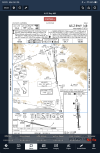
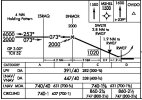
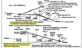
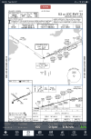
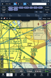
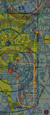
Thinking back to how this went, and thinking about how it would have worked with a Garmin autopilot. We were on the JAIKE4 which ends at SBJ, which is also an IAF for the approach. After the REGLE crossing at 7000, but still several miles prior to SBJ, descending through 5000 feet for 3000, we were given direct VINGS and cleared for the approach.

Doing this with a Garmin, we'd have been in NAV and VNAV on the arrival. Upon getting direct VINGS the lateral would stay in NAV but I'd have to bug 2000 (or better yet, 1300) and I'd probably do a VNAV Direct to the 2000 at VINGS just to be sure. All good so far.

However... My mantra with the Garmin autopilots has always been "hit the APR button when you are cleared for the approach." But, the APR button would arm LOC and GS, and we can't arm GS yet at that point or we'll miss the DANDY restriction by about 500 feet. So really, we need NAV and VNAV still.

As far as intercepting the localizer at VINGS, I expect that my GTN would still auto-switch to the localizer and we could leave the autopilot in NAV and it'd work as intended. We would need to leave the vertical mode in VNAV, with 1300 bugged, until after crossing DANDY and *then* hit the APR button.

So much for "always hit the APR button when cleared for the approach."

Good point on APPR mode taking you early, possibly, into green needles. If you're in LOC mode you won't be able to do VNAV anymore, of course.

I've flown my TwinCo (GTN650) into TEB a few times... not recently. I can't remember which approach I flew or how last time. I can't couple VNAV in that airplane so I'd have to fly the vertical profile manually, or by using the pitch wheel on the AP, which works pretty well too, but I do get to see the vertical profile on the G5s.

It's a lot easier in the work airplanes, and I fly into/out of TEB multiple times per month. It's a riot! (Ugh, not really. GDPs, flow, ramp issues, EWR reducing departures to 5min in trail, the list goes on... Calgon, take me away!)

But anyway, the approach: in recent years the schoolhouse has been big on "platform altitude" and using LNAV and VNAV to end up there. Most often I'm in a G650ER. On the ILS Z or LOC Z Rwy 6 the technique would simply be to set 1300 in the alt preselect with the same two aforementioned modes active. The airplane will cross VINGS and LEESY at or above 2000 and 1700, respectively, and honor the mandatory 1300 at DANDY. Sometime after leveling at 1300 but earlier than a mile or so from TORBY, switch to APPR mode and select the missed approach altitude. Assuming the approach was up 'n ready in Preview (very reliable nowadays on Planeview) you'll flip right into green needles with course set. Pretty simple and very easy to trust the box will get it right.

The weird one can be the missed off of runway 19 or 24; the missed approach altitude is 1500, and it's conceivable you'll get a go-around instruction above that altitude on the approach for spacing/whatever (ask me how I know.) This means your missed approach consists of descending to the hard 1500 altitude. Newark approach takes that altitude restriction VERY seriously as it keeps you out of EWR's way.
 
There are alway exceptions to techniques. Maybe that’s the difference between “technique” and “procedure,” and the reason to understand them. Perhaps better stated as “don’t hit the APR button until cleared for the approach.”
True, but I like to come up with things that work as close to 100% as possible. Commonality = Exercise = less chance of making a mistake.

Good point on APPR mode taking you early, possibly, into green needles. If you're in LOC mode you won't be able to do VNAV anymore, of course.
And that's the other thing - Based on my reading of the manual, a GTN/PFD combo will go to green needles at VINGS. But, if it's already in VNAV and the NAV switches to LOC, will it disable VNAV?

It's a lot easier in the work airplanes, and I fly into/out of TEB multiple times per month. It's a riot! (Ugh, not really. GDPs, flow, ramp issues, EWR reducing departures to 5min in trail, the list goes on... Calgon, take me away!)
Hah! Yeah, good ol' Teterhole. Sat on the ramp for about an hour and a half the other day with engines running, then off, then running again, with pilots pulling traffic-jam shenanigans and getting chewed out and/or punished (in one case) for it. (That guy deserved it.)

But anyway, the approach: in recent years the schoolhouse has been big on "platform altitude" and using LNAV and VNAV to end up there. Most often I'm in a G650ER. On the ILS Z or LOC Z Rwy 6 the technique would simply be to set 1300 in the alt preselect with the same two aforementioned modes active. The airplane will cross VINGS and LEESY at or above 2000 and 1700, respectively, and honor the mandatory 1300 at DANDY. Sometime after leveling at 1300 but earlier than a mile or so from TORBY, switch to APPR mode and select the missed approach altitude.
That's what we did.

Assuming the approach was up 'n ready in Preview (very reliable nowadays on Planeview) you'll flip right into green needles with course set. Pretty simple and very easy to trust the box will get it right.
Must be nice. We don't get plates in the panel. :(

The weird one can be the missed off of runway 19 or 24; the missed approach altitude is 1500, and it's conceivable you'll get a go-around instruction above that altitude on the approach for spacing/whatever (ask me how I know.) This means your missed approach consists of descending to the hard 1500 altitude.
Interesting. Not too surprising though.
 
True, but I like to come up with things that work as close to 100% as possible. Commonality = Exercise = less chance of making a mistake.
Commonality is great. Unfortunately navigating boxes aren’t standardized enough to have commonality.

Arming approach when you’re cleared for the approach worked great when everything was ground-based, but with GPS and other long range navigators, arming approach changes enough other things that it really isn’t a good gouge anymore. Unfortunately I haven’t come up with anything beyond understanding your system and operating accordingly.
And that's the other thing - Based on my reading of the manual, a GTN/PFD combo will go to green needles at VINGS. But, if it's already in VNAV and the NAV switches to LOC, will it disable VNAV?
It probably depends on the system. I can’t speak to Garmin, but Collins (at least through PL21) will maintain VNAV until GS capture or passing the FAF. So it comes back to understanding the individual system and how it handles things, which again goes back to rote procedures not being a good option.
 
Arming approach when you’re cleared for the approach worked great when everything was ground-based, but with GPS and other long range navigators, arming approach changes enough other things that it really isn’t a good gouge anymore. Unfortunately I haven’t come up with anything beyond understanding your system and operating accordingly.
Yep, I mean specifically with Garmin, where it always worked... Until now.

It probably depends on the system. I can’t speak to Garmin, but Collins (at least through PL21) will maintain VNAV until GS capture or passing the FAF. So it comes back to understanding the individual system and how it handles things, which again goes back to rote procedures not being a good option.
Yes, PL21 is what I (mostly) fly at work. I wouldn't pretend to be good enough at it yet to teach it or know all of the best practices, but it's definitely a different best than the Garmin, in both good ways and bad.
 
True, but I like to come up with things that work as close to 100% as possible. Commonality = Exercise = less chance of making a mistake.
Absolutely! I've very big on consistent SOPs for that exact reason - less chance of making a mistake. But another goal is to free up mental bandwidth so one can recognize the situations when they don't apply, not turn them into a straightjacket that, peraps ironically, produces a mistake.

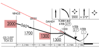
Take this one. One can look at the Profile view - using an SOP for briefing approaches :D - and tell at a glance that going into APR mode early is a mistake.
1792671846870.png
 
It probably depends on the system. I can’t speak to Garmin, but Collins (at least through PL21) will maintain VNAV until GS capture or passing the FAF. So it comes back to understanding the individual system and how it handles things, which again goes back to rote procedures not being a good option.
Garmin setups with enroute VNAV capability will handle it just fine. It will maintain the GPS source until 1300 and auto switch to LOC if auto switch is enabled. There's still a catch. You still need to remember to engage APR at that point.

(Speaking of SOPs, while I keep auto switch enabled as a backup, I prefer to do it manually. Which actually helps on this one since manual switch in Garmin turns off NAV/APR mode, so manual switching on an approach means tapping CDI and APR in sequence, even if you were already in APR mode.)
 
Garmin setups with enroute VNAV capability will handle it just fine. It will maintain the GPS source until 1300 and auto switch to LOC if auto switch is enabled. There's still a catch. You still need to remember to engage APR at that point.

It's been a while since I've been to TEB with a Garmin anything, and I'm pretty sure that approach has changed since. I've also not done it with a GTN, only G3000.

However, according to the manual, it'll auto-switch to VLOC when intercepting the localizer (within 1.2 miles) between 2-15 miles from the FAF. Seems like that'd happen approaching VINGS, and potentially knock off the VNAV?

I really wish Garmin's simulators were for more than one Garmin device. Even if you needed multiple iDevices, one for each Garmin device, and could connect them via Bluetooth, it'd be a lot easier to try some things out prior to flying them.
 
However, according to the manual, it'll auto-switch to VLOC when intercepting the localizer (within 1.2 miles) between 2-15 miles from the FAF. Seems like that'd happen approaching VINGS, and potentially knock off the VNAV?
The new Garmin trainers (other than G1000) can be iffy because of the lack of a real autopilot emulation. I flew this in an older G1000 trainer. As expected, no autoswitch to LOC until TORBEY, the FAF, became the active waypoint. VNAV all the way until then, meeting each stepdown outside the FAF. AFAIK that’s how it’s supposed to work.
 
I think you are misapplying the intent of the TERPS rules you refer to in your post #56. They give the circumstances when Circling Minimums may not be established. We are talking about Approaches where they have been established. TERPS does not establish the rules pilots follow when flying the Approach.
91.175(a) requires that a SIAP be from part 97. 97.20(a) refers to the TERPS 8260.3 and other regulations orders in the 8260 series. 97.20(b) incorporates by reference the various 8260-3, -4, and -5 approach forms as part of the regulation. Approach charts are the interface to the pilot for the output of the TERPS forms. There are two procedures charted on an "ILS or LOC chart". The ILS has vertical guidance and is flown to a DA. The LOC does not have vertical guidance and is flown to an MDA. The ILS has a PFAF depicted by the lightning bolt where the GS intercepts the minimum intermediate altitude. The LOC procedure has a FAF established at outer marker or valid substitute. the The 8260-3 shows the ILS procedure MAP point as the DA and the LOC procedure as a distance from the FAF. There will likely be updates to the AIM to clarify this. You are not excused from complying with all charted minimum altitudes on the LOC procedure, including the FAF, any step downs, and MDA or CMDA. The GS, if available, is advisory when flying the LOC procedure.
 
Last edited:
91.175(a) requires that a SIAP be from part 97. 97.20(a) refers to the TERPS 8260.3 and other regulations in the 8260 series. 97.20(b) incorporates by reference the various 8260-3, -4, and -5 approach forms as part of the regulation. Approach charts are the interface to the pilot for the output of the TERPS forms. There are two procedures charted on an "ILS or LOC chart". The ILS has vertical guidance and is flown to a DA. The LOC does not have vertical guidance and is flown to an MDA. The ILS has a PFAF depicted by the lightning bolt where the GS intercepts the minimum intermediate altitude. The LOC procedure has a FAF established at outer marker or valid substitute. the The 8260-3 shows the ILS procedure MAP point as the DA and the LOC procedure as a distance from the FAF. There will likely be updates to the AIM to clarify this. You are not excused from complying with all charted minimum altitudes on the LOC procedure, including the FAF, any step downs, and MDA or CMDA. The GS, if available, is advisory when flying the LOC procedure.
Yeah. On another, but related subject, what would say a pilot should do in the following situation. The rules say that if conducting an early missed approach you may climb to the missed approach altitude immediately, but make no turns until the missed approach point. On the ORL ILS or LOC RWY 7 you are flying the ILS. Shortly after DNMOR you realize you will have to miss. Should you disregard the altitude restriction at SWLTR because it is *LOC only?
 
TERPS 8260.3 and other regulations in the 8260 series
I have to laugh because I hate what I'm about to say and rant about it when it's applied to the AIM, but since people ar agguing technicalities, here goes : TERPS is not regulatory :D

The resulting procedures - the 8260 series forms defining the procedures - are definitely regulatory. Incorporated by reference into Part 97. But like all FAA Orders, TERPS is an employee manual and can change without following the regulatory notice-and-comment process.
 
Yeah. On another, but related subject, what would say a pilot should do in the following situation. The rules say that if conducting an early missed approach you may climb to the missed approach altitude immediately, but make no turns until the missed approach point. On the ORL ILS or LOC RWY 7 you are flying the ILS. Shortly after DNMOR you realize you will have to miss. Should you disregard the altitude restriction at SWLTR because it is *LOC only?
I realize this question was addressed to someone else, so forgive me for butting-in. In a couple of other threads pilots have advocated transitioning from ILS to LOC procedures and mins if the GS should fail during the approach, and I have recommended against doing that. Your question highlights one of the reasons why I discourage transitioning from one procedure to another mid-approach: confusion. You answered your own question (if I understood it correctly), in that SWLTR is not part of the ILS procedure and does not apply to the missed approach in your scenario. But the fact that you asked the question at all illustrates the risk of confusion when ILS and LOC procedures are charted on the same plate, leading pilots to incorrectly assume that they are the same procedure except for the GS. The are entirely separate procedures. Again, my perspective is that you are correct in that SWLTR does not apply if flying the ILS. You would, however, be obliged to continue to descend to 1500 if you initiated your missed prior to reaching that altitude.
 
No. I am saying there are two procedures printed on the same chart.
Yes!
Pilots must comply with the LOC only procedure if they circle to land. Following the GS inside the FAF provided by the ILS procedure can be used as advisory vertical guidance, but compliance with the LOC procedure minimums is mandatory.
While the AIM states, "circling from a GLS, an ILS without a localizer line of minima, or an RNAV (GPS) approach without an LNAV line of minima is prohibited," I am not aware of any prohibition against flying a circling maneuver from ILS which has charted LOC and circle-to-land minima. Have I missed it?
 
I realize this question was addressed to someone else, so forgive me for butting-in. In a couple of other threads pilots have advocated transitioning from ILS to LOC procedures and mins if the GS should fail during the approach, and I have recommended against doing that. Your question highlights one of the reasons why I discourage transitioning from one procedure to another mid-approach: confusion. You answered your own question (if I understood it correctly), in that SWLTR is not part of the ILS procedure and does not apply to the missed approach in your scenario. But the fact that you asked the question at all illustrates the risk of confusion when ILS and LOC procedures are charted on the same plate, leading pilots to incorrectly assume that they are the same procedure except for the GS. The are entirely separate procedures. Again, my perspective is that you are correct in that SWLTR does not apply if flying the ILS. You would, however, be obliged to continue to descend to 1500 if you initiated your missed prior to reaching that altitude.
No problem, I’m glad you chimed in and hope others do also. I wasn’t really meaning to talk about transitioning from ILS to LOC and vice versa. The issue here is that the 1020 at SWLTR is a mandatory altitude, not just a minimum. So why? It’s because of Approaches to the 18 runways at KMCO. The *LOC only would seem to imply there is no problem screaming through there climbing to the missed approach altitude if you are doing the ILS and miss early for some reason.
 
No problem, I’m glad you chimed in and hope others do also. I wasn’t really meaning to talk about transitioning from ILS to LOC and vice versa. The issue here is that the 1020 at SWLTR is a mandatory altitude, not just a minimum. So why? It’s because of Approaches to the 18 runways at KMCO. The *LOC only would seem to imply there is no problem screaming through there climbing to the missed approach altitude if you are doing the ILS and miss early for some reason.
You mean situational awareness is always a factor?
 
You mean situational awareness is always a factor?
You’re a CFII and I know you do a lot of IPC’s and refresher training. What percentage of pilots do you think would have the insight to not climb to the Missed Approach Altitude when missing early and realize they should continue down to 1020 when doing an ILS, even though the chart says the restriction at SWLTER is for *LOC only? Do you think this Chart should have a Note like on this one?

1793014993902.png
 
You’re a CFII and I know you do a lot of IPC’s and refresher training. What percentage of pilots do you think would have the insight to not climb to the Missed Approach Altitude when missing early and realize they should continue down to 1020 when doing an ILS, even though the chart says the restriction at SWLTER is for *LOC only? Do you think this Chart should have a Note like on this one?
I think that type of note would be a good idea for a situation like this. But there is another related issue.
On the VNY approach, the altitude restriction is on the missed itself, so VNY 1.5 appears in the GPS database. No GPS? DME is required so you can identify the fix.​
On the ORL approach, since SWLTR is a LOC only waypoint, it isn't even in the flight plan sequence if you load the ILS. That doesn't help either.​

I suspect a very small percentage would get this. But I may get back to you eventually on that one. I use a quiz for IPCs. And since I have a few clients who are repeaters, I try to have multiple versions of the quiz with different questions. And at least one "oddball." Based on this discussion, the ORL or the RNAV ILS 7 (at least SWLTR is in the flight plan) scenario will be part of the next one. The mandatory 1500 at MSHEL for the missed makes for a good red herring.
 
Last edited:
I think that type of note would be a good idea for a situation like this. But there is another related issue.
On the VNY approach, the altitude restriction is on the missed itself, so VNY 1.5 appears in the GPS database. No GPS? DME is required so you can identify the fix.​
On the ORL approach, since SWLTR is a LOC only waypoint, it isn't even in the flight plan sequence if you load the ILS. That doesn't help either.​

I suspect a very small percentage would get this. But I may get back to you eventually on that one. I use a quiz for IPCs. And since I have a few clients who are repeaters, I try to have multiple versions of the quiz with different questions. And at least one "oddball." Based on this discussion, the ORL or the RNAV ILS 7 (at least SWLTR is in the flight plan) scenario will be part of the next one. The mandatory 1500 at MSHEL for the missed makes for a good red herring.
Yeah. The wording wouldn’t be just like on the VNY Approach. Something kinda like ‘A descent to 1020 at SWLTR is required when executing an early missed approach on the ILS’
 
...would have the insight to not climb to the Missed Approach Altitude when missing early and realize they should continue down to 1020 when doing an ILS, even though the chart says the restriction at SWLTER is for *LOC only?
I believe that this is overcomplicating the issue by, in the name of "situational awareness," inventing a situation that would not, in fact, exist. The fact that MCO lies to the south of ORL does not mean that one should assume that a traffic conflict would be created by flying the ILS, including the missed approach, as published, in compliance with an ATC clearance. To make such assumptions is not "situational awareness."

From the Instrument Flying Handbook: If the missed approach is initiated prior to reaching the MAP, unless otherwise cleared by ATC, continue to fly the IAP as specified on the approach chart. Fly to the MAP at or above the MDA or DA/DH before beginning a turn.

More to the point, the Aeronautical Information Manual states: Altitude restrictions depicted at stepdown fixes within the final approach segment are applicable only when flying a Non−Precision Approach... These altitude restrictions may be annotated with a note “LOC only” or “LNAV only.” Stepdown fix altitude restrictions within the final approach segment do not apply to pilots using Precision Approach (ILS)... [emphasis added] In other words, if cleared for the ILS, then fly the ILS and disregard features that apply only to the LOC.

In the situation under discussion, upon initiating the missed approach the pilot may climb if below 1500, but must descend if above 1500*, at any point between DNMOR and the MAP. I suspect (but am not certain) that in circumstances in which an aircraft at 1500 on the final approach segment would conflict with MCO arrivals or departures, the ILS approach would not be in use.

*Edited due to the fact that I'm not certain on this point.
 
Last edited:
@RussR, I think your input on this one would be very helpful.
Thanks, but I don't feel that I have much useful input, if by "this one" you're referring to the most recent topic of missed approaches having to descend to make a crossing altitude or not (since this thread has ranged pretty far on topics).

I don't have a lot of input on this because it's an operational requirement, not a TERPS or Flight Check requirement. EXCEPT that if there is what we've taken to calling a "hold-down" altitude on a procedure where you would normally be climbing (like a missed approach or departure), there are some specific obstacle clearance rules that take effect, since you're now in level flight for a while and the clearance criteria changes. But we can assume the procedures as published meet those requirements.

So we're left with "is it safe to delay my climb based on a mandatory altitude", and the answer to that is yes. Alternately, "is it safe to begin my climb immediately", and the TERPS answer for that is also yes - but likely not the ATC answer. Whether an immediate climb is or is not allowed is a regulation/ATC issue, not a TERPS one.
 
Based on this discussion, the ORL or the RNAV ILS 7 (at least SWLTR is in the flight plan) scenario will be part of the next one. The mandatory 1500 at MSHEL for the missed makes for a good red herring.
If, as a CFI, you were to use this scenario as a teaching point, you would be providing instruction to clients based on hearsay that you read on an Internet forum. If you encounter a sharp and well-informed client, how would you respond if asked to cite an authoritative source?
 
I believe that this is overcomplicating the issue by, in the name of "situational awareness," inventing a situation that would not, in fact, exist. The fact that MCO lies to the south of ORL does not mean that one should assume that a traffic conflict would be created by flying the ILS, including the missed approach, as published, in compliance with an ATC clearance. To make such assumptions is not "situational awareness."

From the Instrument Flying Handbook: If the missed approach is initiated prior to reaching the MAP, unless otherwise cleared by ATC, continue to fly the IAP as specified on the approach chart. Fly to the MAP at or above the MDA or DA/DH before beginning a turn.

More to the point, the Aeronautical Information Manual states: Altitude restrictions depicted at stepdown fixes within the final approach segment are applicable only when flying a Non−Precision Approach... These altitude restrictions may be annotated with a note “LOC only” or “LNAV only.” Stepdown fix altitude restrictions within the final approach segment do not apply to pilots using Precision Approach (ILS)... [emphasis added] In other words, if cleared for the ILS, then fly the ILS and disregard features that apply only to the LOC.

In the situation under discussion, upon initiating the missed approach the pilot may climb if below 1500, but must descend if above 1500*, at any point between DNMOR and the MAP. I suspect (but am not certain) that in circumstances in which an aircraft at 1500 on the final approach segment would conflict with MCO arrivals or departures, the ILS approach would not be in use.

*Edited due to the fact that I'm not certain on this point.
How does your analysis apply to the co-located RNAV approach?
 
It has nothing to do with any other approach except the one under discussion. In fact, I haven't even looked at the RNAV approach because it's entirely irrelevant.
Sometime its about the big picture. I mention the RNAV approach because the profile is identical. Sorry, I just don't buy
I suspect (but am not certain) that in circumstances in which an aircraft at 1500 on the final approach segment would conflict with MCO arrivals or departures, the ILS approach would not be in use.
It's pretty clear that if you are on glideslope for the ILS, you will meet the restriction. The idea that Orlando TRACON doesn't clear for the ILS just in case someone goes missed early just doesn't make any sense to me. More likely, an early missed was not even contemplated as part of the design.

So, basically, we are dealing with one approach profile with 7 sets of minimums and a mandatory minimum established for traffic management. You are saying that you don't need to worry about it if you go missed early on only one of the 7. The only answer that makes sense to me, in the absence of an ATC instruction, is that the mandatory altitude applies once you elect to leave the glideslope. Yes, unlike many others, I think the rules do make sense. But also yes, that's just my opinion.

While I disagree with your view, I do understand it. Avoiding that issue is a reason that at this point, my draft quiz question uses the RNAV instead of the ILS.
 
Last edited:
It has nothing to do with any other approach except the one under discussion. In fact, I haven't even looked at the RNAV approach because it's entirely irrelevant.
The RNAV 7 Approach does have the 1020 Mandatory altitude at SWLTR. It applies to to LPV, LNAV/VNAV and LNAV.
 
With specific regard to the RNAV (GPS) RWY 07, I studied the chart and found that the approach should be flown the same as the ILS, when using LPV or LNAV/VNAV procedures to a DA. Look carefully at the following and tell me what they mean, because apparently I don't understand:

KORL RNAV (GPS) 7.jpg

Legend.jpg

Again, from the AIM: Stepdown fix altitude restrictions within the final approach segment do not apply to pilots using Precision Approach (ILS) or Approach with Vertical Guidance (LPV, LNAV/VNAV) lines of minima identified as a DA(H)... That's the official word. What part of that is wrong?

...just doesn't make any sense to me. More likely, an early missed was not even contemplated as part of the design.
Just because it doesn't make sense to us doesn't mean that we should assume that it's wrong and create our own remedies. In aviation, no matter how experienced and clever we may be, we encounter things that we don't understand, often because there always seems to be certain information/knowledge that we don't possess. In that case, we should research the matter until we find a definitive answer instead of forming assumptions, or just making sh#& up.

While I disagree with your view, I do understand it. Avoiding that issue is a reason that at this point, my draft quiz question uses the RNAV instead of the ILS.
Just to be clear, it's not my view. It is official guidance, published in authoritative sources that are available to everyone.

Sometime its about the big picture. I mention the RNAV approach because the profile is identical. Sorry, I just don't buy
The real big picture is this: Authoritative sources, including those previously cited, are very clear in their guidance to pilots regarding procedures to be followed when flying IAPs. The guidance could hardly be more clearly stated.

Maybe you and others here know more than the people who developed and implemented, and over decades revised and refined, those procedures; and people who then established official guidance in the FAA publications that form the basis for IFR operations in the USA. I sure don't, but if you do, perhaps you should get on the phone ASAP and tell them that they're wrong. Then they will issue revisions that I and everyone else can read and incorporate, and we will all live happily everafter.
 
Last edited:
I have to laugh because I hate what I'm about to say and rant about it when it's applied to the AIM, but since people ar agguing technicalities, here goes : TERPS is not regulatory :D

The resulting procedures - the 8260 series forms defining the procedures - are definitely regulatory. Incorporated by reference into Part 97. But like all FAA Orders, TERPS is an employee manual and can change without following the regulatory notice-and-comment process.
Correct, I edited the post.
 
You are correct. I was unaware of that in the AIM.
The *LOC only and *LNAV only that you see on final stepdown fixes in the profile view are gradually going away as procedures are amended. This does not meant they now apply to all, it's just that the charting change was made simultaneously with the change to the chart legend and the AIM, informing pilots that such final stepdown altitudes only apply to LOC and LNAV and LP across the board. I'd say the change is maybe 5 years old or so, but like many changes, is only implemented as the charts are otherwise updated. So you may not have seen this until recently.
 
The *LOC only and *LNAV only that you see on final stepdown fixes in the profile view are gradually going away as procedures are amended. This does not meant they now apply to all, it's just that the charting change was made simultaneously with the change to the chart legend and the AIM, informing pilots that such final stepdown altitudes only apply to LOC and LNAV and LP across the board. I'd say the change is maybe 5 years old or so, but like many changes, is only implemented as the charts are otherwise updated. So you may not have seen this until recently.
Yeah. That’s the case with many Chart questions nowadays. There are many generations of Charting Criteria out there at once. Some go back well more than 10 years ago.
 
Again, from the AIM: Stepdown fix altitude restrictions within the final approach segment do not apply to pilots using Precision Approach (ILS) or Approach with Vertical Guidance (LPV, LNAV/VNAV) lines of minima identified as a DA(H)... That's the official word. What part of that is wrong?
It’s not wrong, but I do think it is dealing with the typical situation: a TERPS based minimum altitude for terrain and obstruction clearance which is already protected by following official vertical guidance. I am just questioning its applicability to a maximum altitude for traffic management purposes in a situation where the pilot is no longer following the official vertical guidance. I expect to see holes where standard guidance doesn’t necessarily apply.

Well just have do disagree.
Rwy 25 is interesting. What traffic do you think they are trying to miss with the 2000 at ENLOW?

1793108006120.png
1793108126594.png
 
Rwy 25 is interesting. What traffic do you think they are trying to miss with the 2000 at ENLOW
Sometimes it's not obvious. But I always figure that an upper limit isn't about terrain or obstacles :D

Offhand, I'd guess downwind traffic on visual approaches when landing to the north. I'll check...

Looks like it. Snapshot right now. But it could also be because of base traffic to SFB.

1793113999951.png
 
It’s not wrong,
Then we should do it.
but I do think it is dealing with the typical situation:
With regard to a case in which you reject or deviate from established procedures and standards, shouldn't you know?

You are basing your entire argument on nothing more substantial than an assumption: you noted a mandatory altitude associated with a stepdown fix on the LOC approach. You also know that a nearby airport has approach and departure paths in the vicinity. Without any more information than that, you assume that the stepdown fix restriction is established to prevent traffic conflicts with aircraft operations to/from the nearby airport. Then, you misapply that conclusion to the ILS. In fact, the altitude at SWLTR may have nothing to do with MCO traffic. We can't know from the information presented in this thread.

As for "typical situation," the procedure (ILS) is to be flown as charted or as amended by ATC clearance. When a non-typical situation arises, e.g. a traffic conflict in which the procedure cannot be flown as charted, either the procedure will be amended by ATC or a clearance will not be issued. So if you are cleared to fly the ILS, you need not be concerned with the SWLTR restriction as ATC is providing traffic separation according to their SOPs.

What I find most troubling is the fact that you have stated your intent to teach your assumption-based misunderstanding to your clients and students. As a CFI, you have a professional obligtion to make certain that what you teach is true, factual, and supported by authorative sources (in this case, the charted procedure, IFH, and AIM). I admit that my posts to this thread are rather strong in tone (and I do not mean to cause offense), but if I were paying a CFI for a flight review or IPC and he/she presented this scenario along with the informal fallacy that you are using as a rationale, I'd be inclined to give that CFI a very hard time.

I am just questioning its applicability to a maximum altitude for traffic management purposes in a situation where the pilot is no longer following the official vertical guidance.
The published missed approach IS the official vertical guidance. The AIM and IFH tell us how to fly it.

I expect to see holes where standard guidance doesn’t necessarily apply.
Nice segue, as you have given me the impression that you may be a victim of two potentially hazardous psychological traps: expectation bias, and confirmation bias. You expected to see a hole, you found a detail that you were unfamiliar with, and you created the hole that you were expecting to see. Then, when presented with incontrovertible and definitive evidence that did not confirm your belief, you rejected the evidence. Classic! Here's a brief synopsis of certain psychological biases, from our friends at the FAA (who sometimes really are here to help).

Well just have do disagree.
Just understand that it is not I with whom you disagree.
 
Last edited:
You are basing your entire argument on nothing more substantial than an assumption: you noted a mandatory altitude associated with a stepdown fix on the LOC approach. You also know that a nearby airport has approach and departure paths in the vicinity. Without any more information than that, you assume that the stepdown fix restriction is established to prevent traffic conflicts with aircraft operations to/from the nearby airport.
That's OK. When I make the same insubstantial assumption as the US Air Force and the Instrument Procedures Handbook, I figure I'm in good company. So I'm pretty sure I'm only disagreeing with you.

Oh, and don't get tooo worried about my quiz. They are always well-documented with references. That's why it's only a draft at this point.

Besides, I'd rather be wrong telling someone to avoid a potential loss of separation with overhead traffic than being wrong telling them it's OK to do it.
 
Last edited:
That's OK. When I make the same insubstantial assumption as the US Air Force and the Instrument Procedures Handbook, I figure I'm in good company.
1. I suggest that, if you are a professional aviator, it is not okay.

2. I do not have access to the Air Force's Instrument Procedures Handbook, so I cannot compare USAF procedures to those of the FAA. But I doubt that anything in the USAF Instrument Procedures Handbook is based on insubstantial assumptions. What I can say is that, if you are an Air Force pilot flying an Air Force aircraft, by all means, follow the training and guidance provided by the Air Force. When you are flying a civil aircraft (in the USA) as a civilian pilot, follow the training and guidance provided by the FAA.

3. My father was a career USAF pilot. When I was a kid with a proclivity for making unfounded assumptions, he would admonish me with the old saw that, "when you assume, you make an ass out of you and me." I assumed that he learned that from the Air Force.

Sorry--had to edit to add the paragraphs below due to operator error.

Oh, and don't get tooo worried about my quiz. They are always well-documented with references.
Would you kindly share the documentation and references you use with regard to this matter?

Besides, I'd rather be wrong telling someone to avoid a potential loss of separation with overhead traffic than being wrong telling them it's OK to do it.
There's a fair amount of straw poking out of that statement. You have not established a case in which flying the ILS RWY 07 procedure, and executing the published missed approach, will create a potential loss of separation with overhead traffic. No one in this thread has stated or implied that creating a loss of separation is okay.
 
Last edited:
Back
Top