Garmin Pilot for Android -- Tech Support, Tips, Tricks

Well I still haven't flown real world yet but I have 'flown' it in the Jeep and on the sim and ran it for hours on my desk and this update is really working smoothly for me so far and added most of the feature set I have been waiting on.

With SAR patterns and a few other added features GP will have everything I want.

Good job Garmin.

'Gimp
 
I "flew" it on Friday. Short flight, though, and I was getting checked out in a new-to-me-airplane so didn't get a lot of time to play with it.

I did see one time where only half the display was working - half was blank. I don't know what happened, or how, but I touched the screen and it redrew just fine. I turned on the 5/10NM range rings. That was pretty handy for estimating distances when tower wanted me to report 3 miles s/e of the field. And the extended rwys were a nice touch.
 
FWIW, my Garmin Pilot updated to version 3.0.1 last night and it has fixed the issue I reported earlier in this thread with sectional & enroute charts being very pixelated/unclear when zoomed out a bit.

Thanks Garmin!
 
FWIW, my Garmin Pilot updated to version 3.0.1 last night and it has fixed the issue I reported earlier in this thread with sectional & enroute charts being very pixelated/unclear when zoomed out a bit.

Thanks Garmin!
Nice. I just downloaded a bunch of updates, but they were all charts. Waiting to get my 3.0.1 update.


edit:

Just got the update, installing now.


edit again:

Much better.
 
Last edited:
Hey folks, first post here.

I read the whole thread. (Hi, my name is John and I read...)

It was mentioned that the crew at Garmin might be watching so I thought I would mention a couple of things:

I created a MyGarmin account so that I could check out the connectivity with GP(a). MyGarmin suggested I use my email address as an account ID so I cut and paste(d) email address for the ID. GP(a) does not accept symbols in the ID field so I am blocked at the '@'. (I have asked MyGarmin support to delete my account or change the ID and I will try again.)

I am using a Samsung Galaxy Note 8. When brand new and void of user apps it has only about 9G available space. Sdcard0 is mapped into that same space. I have a 64G external SD card on this device [extSdCard] but I can't get to it with GP(a) so I can't download all. In fact, I need to be careful because GP(a) is not the only app I have installed.

Currently, the account created in GP is not connected or related to the MyGarmin account you would create on the Garmin website (there is no sharing of information between the two systems), so there is no reason to keep them the same (other than convenience).

GP doesn't support moving the chart data to the SD card (yet), so you'll need to pick-and-choose what you download.
 
FWIW, my Garmin Pilot updated to version 3.0.1 last night and it has fixed the issue I reported earlier in this thread with sectional & enroute charts being very pixelated/unclear when zoomed out a bit.

Thanks Garmin!

Yeah nice work Garmin, GP is killing it now. :cornut:
 
Currently, the account created in GP is not connected or related to the MyGarmin account you would create on the Garmin website (there is no sharing of information between the two systems), so there is no reason to keep them the same (other than convenience).

Oh, I guess I thought that's where folks are syncing their devices. Okay, so my Garmin Pilot account is something different and I will know what that is when I have finished my 30 day demo and purchase it.

And that explains why I couldn't figure out how I was supposed to "register" GP at MyGarmin. :thumbsup:

GP doesn't support moving the chart data to the SD card (yet), so you'll need to pick-and-choose what you download.

And this is of course what I am doing. But user request prompts change so, ... please? (And I see "(yet)" as a positive response. :yes:)

Thanks for the response.
 
FWIW, my Garmin Pilot updated to version 3.0.1 last night and it has fixed the issue I reported earlier in this thread with sectional & enroute charts being very pixelated/unclear when zoomed out a bit.

Thanks Garmin!

Charts are now breathtakingly sharp on the Nexus 7. Repainting them seems a tad slower, but the quality is great.
 
Flew latest update a bunch during All Red Star formation clinic in Porterville (I was backseat, 5 sorties for more than 6 hours of flight time), worked great on the Samsung Galaxy Note 8.0 - very happy with it now.

'Gimp
 
Charts are now breathtakingly sharp on the Nexus 7. Repainting them seems a tad slower, but the quality is great.

crystal clear. does it also seem like you can zoom in more or am I imagining that?
 
On the android version of garmin pilot is there a way to determine control tower hours of operation? I found facility hours, but that's probably the FBO, since the given times are different than those in the digital AF/D on the faa website.

This has to be there... I'm just not seeing. Right?
 
On the android version of garmin pilot is there a way to determine control tower hours of operation? I found facility hours, but that's probably the FBO, since the given times are different than those in the digital AF/D on the faa website.

This has to be there... I'm just not seeing. Right?

You have the current A/FD in Garmin Pilot. Get to the full airport information page (tap on the little i in the upper right corner of the popup), then tap on the A/FD button in upper right.
 
thanks. I spent a few hopeful minutes looking but I didn't see it. Love to be wrong about this.

(C'mon garmin... I don't expect feature parity, yet, but no AF/D? Just gimme the pdfs and launch a viewer, all I really need is an easy way to get the data automagically updated.)

((While I'm bitching, wtf FAA? Single page AF/D downloads?))

Sadly, I think you're correct. I couldn't find it on my Android. I don't think feature parity is too much.
 
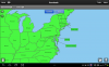
I've just sent a note about this to Garmin, but I ran into a huge issue tonight. I keep the eastern 1/3 of the country on my tablet - see "gp2.png" for a screen shot showing current approach plates for the eastern seaboard. This includes, specifically, both Virginia and Washington DC.

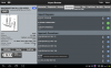
Yet when I go to the Washington Dulles (KIAD) airport page, note that many of the approaches and arrivals are marked with the blue "need to download" icon, and clicking on one of them (with Internet/Wifi disabled) gives the error "cannot connect to server".

Luckily I found this during flight planning but could you imagine being in IMC talking with Potomac and discovering that the charts you downloaded were just missing?

(Yes, I carry a backup, but the point is that if the charts say they're downloaded, why aren't they? And how can I _really_ download all the charts in the regions of interest?)

Like I said, I reported this to Garmin already but it has the potential to be a pretty big issue if encountered in flight, so I thought I would post here as well.


Steve Lin
 

Attachments

  • gp2.png
    gp2.png
    156.6 KB · Views: 24
  • gp4.png
    gp4.png
    538.7 KB · Views: 24
Status update:

I rebooted my tablet, and this time the "missing" charts are there - hooray, just a little Android/Pilot glitch!

I re-enabled Wifi (recall I had previously disabled Wifi to see what would happen when I clicked on a "missing" chart), and Garmin Pilot promptly crashed.

sigh...
 
Wow -- glad to see this old thread still going strong. :)

Mary and I still love running Garmin Pilot on our Nexus 7 (2013) in the back seat of our RV-8A, but with a new twist. We now have our tablet bluetoothed to our new GRT Horizon HXr EFIS, too, giving us a complete EFIS in the back cockpit.

Using the Nexus 7's ability to multitask, we are also bluetoothed to the Garmin GDL-39 ADS-B receiver, giving us traffic and weather overlaid on sectionals in Garmin Pilot.

With a simple button push, we can now toggle back and forth between the EFIS and Garmin Pilot. It's an amazing, awe-inspiring, almost too good to be true set up!
 
I saw a red RV-8A with Amelia's Landing painted on it at 11R recently ....

I wonder who that was???? :D:goofy:
 
Hey! I wonder? :D

Did you say hi to us? :goofy:


The cafe was busy, I looked for a guy with a beard, (if you still have one) but no joy.... then my buddies wanted to go ... so maybe next time. But I was lookin' ...

Nice bird by the way. I looked inside at the EFIS. Can you play Call of Duty on that thing? :D
 
Just wanted to say that I have been flying finally with latest GP and am pretty happy with overall functionality and performance on my Samsung Galaxy Note 8.0 although battery life has gone down recently (not GP related, my belief) - I do have an update to download (Samsung) when I get home in an hour.

'Gimp


I have as well, GP has come a long way with the recent update and I'm pleased with it on the Android platform.

I intend to purchase a GDL 39 3D to replace the plain old GDL 39 this summer. Does anyone have experience with the attitude indicator display?
 
Something I was trying to do last night: turn on range rings to 250 -300NM. Has anyone found a way to do that? The best I could do was to set up the distance tool, then drag one end of it around in a circle centered on my home airport.
 
Something I was trying to do last night: turn on range rings to 250 -300NM. Has anyone found a way to do that? The best I could do was to set up the distance tool, then drag one end of it around in a circle centered on my home airport.


I don't believe you can set them that far out. I think 15,30nm is the max, see the attached screen shot. Get to this screen by selecting the stacked paper icon in the bottom left, then select "Ownship/Route"

CeVqzZZ.png
 
Just got the update notification for 3.0.2.

Installing now.

Version 3.0.2

Fixed: Map rotation issues using track up when the aircraft is taxiing.
Fixed: Incorrect rotation of the VOR compass rose with W variation.
Fixed: Issue causing the GPS Pulse Animation OFF option to not function.
Improved: Performance enhancements to the maps.
Fixed: Various reported fixes and crashes.
 
..jaded flyer says ..

Still no synthetic vision for the Android platform?

C'mon Garmin!

You're doing well with support and updates for GP android, don't drop the ball ... :nono:
 
Been flying regularly with Garmin running on the Samsung Note 8.0 and no issues to report with the app itself, just running very stable. I was hoping for a quality improvement when zoomed in on the latest Los Angeles Sectional but seems about the same which is to say it does pixelate a little at maximum zoom, same for the TAC charts.

Tried the car charger for the first time today in the Citabria and it kept the tab topped off easily in the morning but I did hit a temp limit this afternoon due to the greenhouse skylight between the wings and had to unplug for a while but that is a hardware not software issue.

Remaining very pleased with the app and how it runs on the Note 8.0, great form factor for cockpits with sticks.

'Gimp
 
First use of the GP trial on a Nexus 7 was a pair of 5 hour flights to Maine last weekend. Worked well and I really liked the ability to tap on a MOA and get its altitudes and Center frequency. Being the weekend of the 4th they were all cold - yea.

The only negative, besides being behind the Apple version, is requiring the GDL 39. Now I need to decide if the Ipad mini and WingX are worth the extra money for ADSB receiver flexibility.
 
Be sure to consider the Skyguard IN/OUT ADS-B device as well, it gives me pretty much the same traffic picture that ATC sees, plus the free weather as well as AHRS. Works with WingX (iOS), Xavion (iOS), iFly (iOS + Android), Naviator, (Android), Avare (Android), etc... I sure did like the lightning and high-resolution radar depiction of GP though. It'd be great if ADS-B can be upgraded to directly include lightning data some day.
 
Last edited:
Thanks, I like having choices even though it makes it harder for the developers. The original plan was to use GP on the first half and iFly on the second half of the trip but a problem downloading iFly (until today) meant ten hours with GP. GP did all I needed and is the one for the others to beat.

The Clarity ADS-B impressed me at the AOPA conference last fall, pricey but a nice package. I haven't gottten to the point of comparing individual ADS-B units, but that might drive the software choice.

Wife wants a tablet so she may get my Nexus and I buy a Mini or the new Nexus 8 when it comes out.
 
Back
Top