[ForeFlight, GTN750] Crossing radials as part of your clearance

AggieMike88

Touchdown! Greaser!
Joined
Jan 13, 2010
Messages
20,805
Location
Denton, TX
Display Name

Display name:
The original "I don't know it all" of aviation.
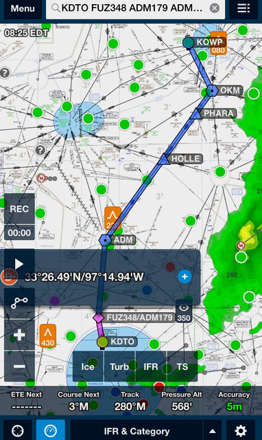
On a PnP trip between KDTO to KOWP (near Tulsa) Saturday, we were provided this routing in our clearance
FUZ348 ADM179 ADM V161 OKM DIRECT KOWP

I was along for the ride as dog wrangler and to gain some exposure/experience in this Bonanza. But both myself and the PF were stumped how to define in the GTN750 equipped on the plane and FF on our iPads the point in lateral space defined by the intersection of those two radials (348° off of the Ranger VOR and 179° off of the Ardmore VOR). And this was my first time to be given a clearance such as this.

But now I've figured it out and wanted to share with the rest of you.

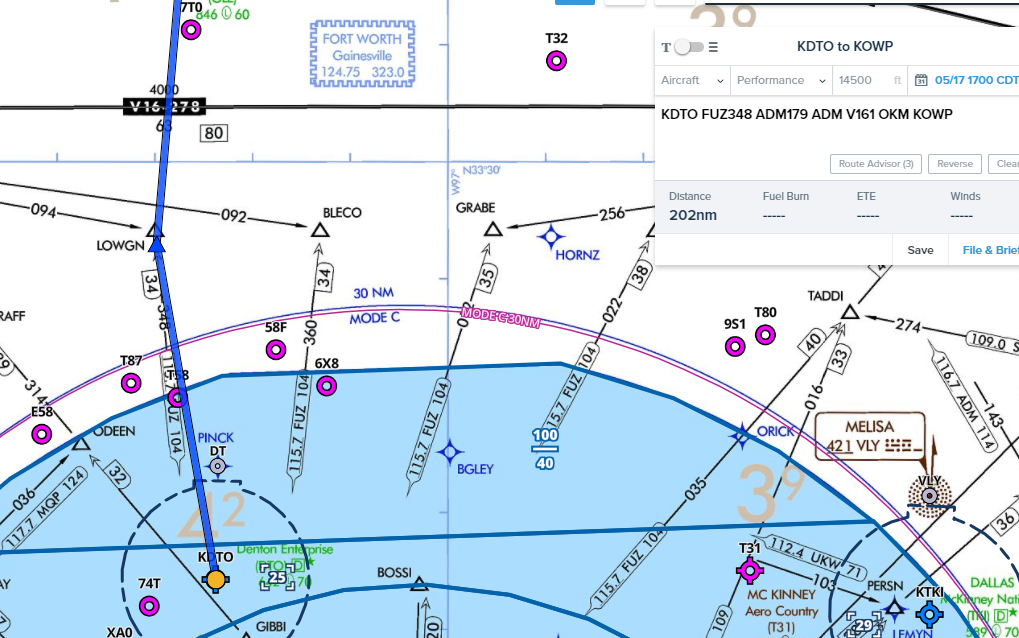
For Foreflight, it's super easy. In the flight plan edit box, you type in "FUZ348/ADM179" and that will define the point. So the entire entry in FF is

KDTO FUZ348/ADM179 ADM V161 OKM KOWP
____________________________________

For the GTN 750 (and I would guess the GTN650 too), an extra step is needed to enter this flight plan. You first must define a user waypoint for the crossing radials.

From the Main Menu, go to Waypoints then Create New Waypoint. On the left, hit the button that determines how you are definining the point until it says "Radial/Radial". Enter a name for your new point (say "PNP1", then enter "FUZ" "348" on the first line and "ADM" "179" on the second. Then save it.

Then go to the flight plan and enter the route
KDTO PNP1 ADM V161 OKM KOWP
____________________________________

The actual flying had us taking off toward the south. Then after a vector to turn northbound, we never got to PNP1 as we were cleared direct ADM. Then a short time later, direct KOWP.

But still, it was interesting to 1) get this different type of clearance and then, (2) figure out how to enter it into the avionics if it happens again.
 
Ugh, why do controllers do this? Is it just a hold my beer and watch this between controllers? Do we not have enough waypoints to make life easier for all?
 
Ugh, why do controllers do this? Is it just a hold my beer and watch this between controllers? Do we not have enough waypoints to make life easier for all?
Remember, the controllers are just reading the strip.... so the frustration needs to be pointed at the computer system that spat out that strip.
 
Remember, the controllers are just reading the strip.... so the frustration needs to be pointed at the computer system that spat out that strip.

It's a trivial route when flown by VORs.

Believe me, that's a LOT better than getting a lat/lon in your clearance. I've made a lot of those for SAR purposes. It sucks.
 
Ugh, why do controllers do this?
Because that is how the ATC computer thinks.

My question is why didn't the avionics manufacturers make their software so that it would match how the ATC computer already worked?
 
It looks like it's not so easy to enter with fltplan go. A custom waypoint might be the only way to handle it precisely. The good news is the intersection is near and slightly west of DTO so I suspect flying to the 179 ADM radial and turning north to ADM via that radial would be fine with ATC. If you were /A or whatever the equivalent ICOA nomenclature is then you'd have to do something like that anyway or get a vector.
 
I have found that radials like that typically are actual waypoints. Controller just didn't know or forgot you are /G.
That is a really cool 750 trick though. Putting that in my bag of tricks
 
I have found that radials like that typically are actual waypoints. Controller just didn't know or forgot you are /G.
That is a really cool 750 trick though. Putting that in my bag of tricks
Oh he knew... because that's how we have the aircraft profile set up in FF.

In this case, it wasn't a defined intersection for that exact spot. However, just about 1 NM north is LOWGN, but that is defined by FUZxUKW. And I'm guessing it wasn't given by the routing computer since we needed to be going toward ADM to get to the Tulsa area.

But now that I know that LOWGN is "close enough", I'll use that if I ever get this same routing in the future

IMG_0226.PNG
.
 
Oh he knew... because that's how we have the aircraft profile set up in FF.

In this case, it wasn't a defined intersection for that exact spot. However, just about 1 NM north is LOWGN, but that is defined by FUZxUKW. And I'm guessing it wasn't given by the routing computer since we needed to be going toward ADM to get to the Tulsa area.

But now that I know that LOWGN is "close enough", I'll use that if I ever get this same routing in the future

View attachment 53583
.
If you don't have ICAO surveillance and equipment set up in Foreflight, he didn't know. It's no longer enough just to say you're /G.

Same deal for filing T routes.
 
I'm lazy and don't like creating user defined waypoints. I'd probably ask for an amendment to the routing to go direct ADM. usually when you see these types of computer generated routes the intersection is actually a published fix.
 
I just set foreflight to only display bends, I punch it, use the waypoints, in this case one user waypoint (takes like 10 seconds to put lat/lon in) and bada bing.

image.jpg
 
A user-defined radial/radial waypoint is less subject to error than manually entering LAT/LON.
 
A user-defined radial/radial waypoint is less subject to error than manually entering LAT/LON.

If you set foreflight and your GPS to use the same lat/lon format this isn't a problem, you should also be double checking, no matter what method you use, which between the flight plan view in FF and your flight plan in put into your GPS, doesn't take but a second.
 
Ugh, why do controllers do this? Is it just a hold my beer and watch this between controllers? Do we not have enough waypoints to make life easier for all?
LOL. Nah, it isn't controller amusement. You tend to find those kinds of routes in congested airspace where things are run tight. There arent enough published airways to use to keep the metal moving if every one had to be on one of them. Also to go around restricted airspace sometimes. Sometimes they eventually become airways. The POM164 radial was used hundreds of times a day and eventualy became V363. The PXN301 radial to SUNOL was another that was a routine route element that became V301 eventually.
 
Last edited:
If you set foreflight and your GPS to use the same lat/lon format this isn't a problem, you should also be double checking, no matter what method you use, which between the flight plan view in FF and your flight plan in put into your GPS, doesn't take but a second.

Umm, yes it is.

Confusing seconds with decimal minutes is one source of error, but it's far from the only one.

It's quite easy to transpose digits when you have a long string of them to copy, for instance.

Some of us do this sort of thing often. Rad/rad or rad/dist is far less error prone than a string of numbers.
 
Flightstream 510 to the rescue! Just enter the radial intersection in Foreflight (or Garmin Pilot) and "send" to the GTN750.

(I think. Haven't tried it. Not everything translates when uploading the flight plan, i.e. certain departures.)
 
Flightstream 510 to the rescue! Just enter the radial intersection in Foreflight (or Garmin Pilot) and "send" to the GTN750.

(I think. Haven't tried it. Not everything translates when uploading the flight plan, i.e. certain departures.)
Once you try it, let us know if it worked.
 
ForeFlight Web version it looks like it plots it correctly. Or am I missing something?

BjfXxdh.png
If if cut and paste your route into
 
Umm, yes it is.

Confusing seconds with decimal minutes is one source of error, but it's far from the only one.

It's quite easy to transpose digits when you have a long string of them to copy, for instance.

Some of us do this sort of thing often. Rad/rad or rad/dist is far less error prone than a string of numbers.

And I don't do it, you know I fly for work and fly backcountry for fun

Anywho, IM(not always)HO..

If you set both to display the same format that's that.

If you transpose a radial you're up a creek too
 
ForeFlight Web version it looks like it plots it correctly. Or am I missing something?
Nope... you got it correct.

The main point of the thread is that while sitting in the aircraft having just got the clearance, we were stumped as to how to enter it into our systems. But now I figured it out and have added it to my bag of knowledge.
 
Maybe it is an Oklahoma thing. My first IFR flight after getting my ticket was to OKC. It was clear and a million, but I filed both ways. The typical route out of OKC back to the Wichita are is some radial out and then the such and such radial off of pioneer to the pioneer vor. I was trying to figure out how in the hell to inter this into the 750, looked at firelight and just a mentioned above, the intersection of the radials was a waypoint. Very proud of myself that I figured it out and was ready to fly. Took off and got vectors and never any of it. Same thing happened to me Sunday. I was in Destin and got a routing with a victor airway. The G1000 is new to me and it took me a while to figure out how to load the airway, got this ridiculous clearance in the box and after a few vectors, direct destination.

Jim
 
Maybe it is an Oklahoma thing
Similar story for @JCranford and I when returning from getting breakfast at KOUN. We got a fairly long routing, read it all back correct, got it twisted and pushed into the CNX80. Then 90 to 120 seconds after "Radar Contact" from OKC Departure, we were given direct Denton (our destination).

So expect the long and crazy... then enjoy the short cuts!
 
And I don't do it, you know I fly for work and fly backcountry for fun

Anywho, IM(not always)HO..

If you set both to display the same format that's that.

If you transpose a radial you're up a creek too

Radials only have three numbers. That's why they are less error prone.
 
It's a trivial route when flown by VORs.

Believe me, that's a LOT better than getting a lat/lon in your clearance. I've made a lot of those for SAR purposes. It sucks.

Agreed. There are some things that, while they can be flown with GPS, are just plain easier to fly as stated.

MAKG1 & midlifeflyer are correct.

I few years ago I talked with a pilot that said they could not shoot a VOR approach into a certain airport because it was not in the box. I asked him why they did not just tune up the VOR go green needles and shoot it, no box needed. It did not sound like they had even thought of it!
 
I few years ago I talked with a pilot that said they could not shoot a VOR approach into a certain airport because it was not in the box. I asked him why they did not just tune up the VOR go green needles and shoot it, no box needed. It did not sound like they had even thought of it!
I'm not surprised that it has come to this.
 
Well you also have the VOR
There are MANY fewer of them, and Garmin 600/700 series and G1000 identify them. Getting one letter wrong is a lot more obvious than a several mile error you get from transposing minutes over empty land.

I've done both....some transposition errors are obvious, but there are quite a lot that aren't.

I had a right seater enter latitude 35 35.0 instead of 37 35.0 just the other day. I knew it was wrong because it was over water and shouldn't have been. But if he had made a north or east error, it would have taken a much closer look.

You're still comparing your flight plan off foreflight with your flight plan in your garmin, that takes but a second and easily show any errors.
 
Routes with radials are a vestige of the days when VOR or VOR/DME is all we had. Many preferred routes use radials to service the least common denominator. New routes are not necessarily available that are designed for RNAV GPS based navigation which is point to point, not radial to intersecting radial. Airlines want to be able to enter the routes automatically into their FMS via CPDLC. These older routes can't be loaded, so the FAA is updating the routes to being RNAV compatible which makes them FMS compatible. It will take many years before these routes are updated, particularly for city pairs where the airlines don't fly.
 
Interesting tip for FF, thanks. I'll have to try it on the tablet when I get home.
I tried it in the web interface and failed. Jim, did you have to do anything special to get that routing to get accepted? I also tried with the slash.

I too would probably say unable to the intersection and either ask for a named one or for RV to ADM. But I wonder whether I would get anything different. :D

And guys, don't blame the computer. It is not at fault here. It does not have artificial intelligence or anything. It is just programmed based on what some monkey decided are suitable criteria. Obviously they monkey failed to cover all corner cases (as is our nature).
 
This is a great tip! Funny enough, I had a brief exchange with a controller about a week ago about how one would fly the KSMX runway 30 ODP if the GLJ VOR is OTS. I didn't know it was possible to define user waypoints in this way. Time to re-read the 430W manual.
 
This is a great tip! Funny enough, I had a brief exchange with a controller about a week ago about how one would fly the KSMX runway 30 ODP if the GLJ VOR is OTS. I didn't know it was possible to define user waypoints in this way. Time to re-read the 430W manual.
A really easy alternative for that purpose is OBS mode.
 
Interesting tip for FF, thanks. I'll have to try it on the tablet when I get home.
I tried it in the web interface and failed. Jim, did you have to do anything special to get that routing to get accepted? I also tried with the slash.
If you do it in the app, when you tap in the search box, it tells you the acceptable formats for creating various waypoints based on courses and distances. For example, the KSMX ODP @clarkmueller mentioned a few posts ago is KSMX GLJ GLJ300/MQO137 MQO in ForeFlightease.

There's basically two different formats. Fix/Course From/Distance for a point in space. FixCourse From/FixCourse From for an intersection. Fix does not have to be a navaid and you don't need an R.
 
Last edited:
I'm not surprised that it has come to this.
Agreed. You're really just talking about a simple VOR intersection intercept. However, if you unnecessarily employ GPS to the milieu here, a simple method would be add one user waypoint at FUZ348/ADM161, but that's a minute of my life I'll never get back. Using the VOR is much easier than the re-programming.
 
Back
Top