FAA "Flight Check" pilot - ask me anything

More of a TERPS question than Flight Check, but. Is publishing True Course on Charts going to be a new thing?

View attachment 144672

No. All prototype charts (known as "Flight Inspection Graphics", notice the abbreviation "FIG" on the bottom of the prototype - not included in your screenshot though), contain true courses. This can be useful when doing pre-publication review, especially with VOR/ILS approaches, as the magnetic declination/variation of record of the various facilities may be different from each other. That can be seen with the various facilities on this chart - they all have different differences between True and Mag.
 
No. All prototype charts (known as "Flight Inspection Graphics", notice the abbreviation "FIG" on the bottom of the prototype - not included in your screenshot though), contain true courses. This can be useful when doing pre-publication review, especially with VOR/ILS approaches, as the magnetic declination/variation of record of the various facilities may be different from each other. That can be seen with the various facilities on this chart - they all have different differences between True and Mag.
Ok. That answers what my next question was probably going to have been. Why are the differences 14, 15 or 16 degrees when SBA is between the 12 degree East and 11 degree 30 minute East variation lines.
 
Ok. That answers what my next question was probably going to have been. Why are the differences 14, 15 or 16 degrees when SBA is between the 12 degree East and 11 degree 30 minute East variation lines.

A VOR radial doesn't use the current magnetic variation for the area, it uses the magnetic variation of record for the station, known as the station declination. This is because it's a big deal (a lot of work) to update the radials each time the mag var changes, for no real gain. So the VOR's assigned mag var gradually gets further and further away from the actual mag var, especially recently as the magnetic north pole has been moving pretty quickly. Once in a while the VOR will be "rotated" (electronically) and then it will match the local mag var, until it gradually changes again.
 
How many flight check aircraft does the FAA have, and what’s the backlog for certifying new approaches?

Our runway at GKT was totally rebuilt 150’ south of its previous location this year and we’re told the approaches won’t be certified for three YEARS. Is that normal?
 
How many flight check aircraft does the FAA have, and what’s the backlog for certifying new approaches?

Our runway at GKT was totally rebuilt 150’ south of its previous location this year and we’re told the approaches won’t be certified for three YEARS. Is that normal?
Ahhh…that explains the somewhat buried NOTAM and a Beechtalk thread about the lack of authorized approaches until 2027.
 
How many flight check aircraft does the FAA have, and what’s the backlog for certifying new approaches?

Our runway at GKT was totally rebuilt 150’ south of its previous location this year and we’re told the approaches won’t be certified for three YEARS. Is that normal?

We have 17 King Air 300s and 6 Challenger 605s. The King Airs are divided among the 5 regional offices (Sacramento, OKC, Battle Creek MI, Atlanta, Atlantic City) with about 3 in each location and the remainder in OKC (usually in some type of maintenance or phase inspection). The 605s are all based in OKC but are used primarily for international work and some domestic work.

Checking the IFP Gateway: https://www.faa.gov/air_traffic/flight_info/aeronav/procedures/ , it shows the new procedures at GKT scheduled to be published 4/15/27. So definitely not 3 years, more like 16 months from now.

The issue isn't the availability of flight check aircraft, it's the behind-the-scenes work that goes into the runway survey data and developing the procedures to the new runway location. It's just an assembly line, with lots of work to be done and the fitting of the new procedures into the development pipeline. Whether 16 months is reasonable or not is a matter of opinion, of course.

While I don't know anything about GKT specifically, I will say that the best and most timely results I've seen has been when the airport manager (or other proponent) starts working with the procedures teams EARLY - like way before construction even begins. That way things can get rolling and scheduled simultaneously with construction. This isn't always possible, of course, but the earlier things start, the better. For example, when GDJ added their new runway 1/19, I flew a flight check of the procedures in maybe September or October of 2022 - this was after the runway was physically there (so the actual, as-built coordinates were known) but before any of the striping or lighting was installed (though they were working on it). The new runway was opened effective the same day the procedures were published in November of 2022. I do believe the procedures were temporarily NOTAMed NA at night until we could get back to check the runway and other lights - remember, those hadn't even been finished yet when we flew it. But that meant that in this case, there was literally no delay between opening the new runway and having the new procedures published.

 
Last edited:
We have 17 King Air 300s and 6 Challenger 605s. The King Airs are divided among the 5 regional offices (Sacramento, OKC, Battle Creek MI, Atlanta, Atlantic City) with about 3 in each location and the remainder in OKC (usually in some type of maintenance or phase inspection). The 605s are all based in OKC but are used primarily for international work and some domestic work.

Checking the IFP Gateway: https://www.faa.gov/air_traffic/flight_info/aeronav/procedures/ , it shows the new procedures at GKT scheduled to be published 4/15/27. So definitely not 3 years, more like 16 months from now.

The issue isn't the availability of flight check aircraft, it's the behind-the-scenes work that goes into the runway survey data and developing the procedures to the new runway location. It's just an assembly line, with lots of work to be done and the fitting of the new procedures into the development pipeline. Whether 16 months is reasonable or not is a matter of opinion, of course.

While I don't know anything about GKT specifically, I will say that the best and most timely results I've seen has been when the airport manager (or other proponent) starts working with the procedures teams EARLY - like way before construction even begins. That way things can get rolling and scheduled simultaneously with construction. This isn't always possible, of course, but the earlier things start, the better. For example, when GKY added their new runway 1/19, I flew a flight check of the procedures in maybe September or October of 2022 - this was after the runway was physically there (so the actual, as-built coordinates were known) but before any of the striping or lighting was installed (though they were working on it). The new runway was opened effective the same day the procedures were published in November of 2022. I do believe the procedures were temporarily NOTAMed NA at night until we could get back to check the runway and other lights - remember, those hadn't even been finished yet when we flew it. But that meant that in this case, there was literally no delay between opening the new runway and having the new procedures published.
“…GKY added their new runway 1/19…” ??
 
We have 17 King Air 300s and 6 Challenger 605s. The King Airs are divided among the 5 regional offices (Sacramento, OKC, Battle Creek MI, Atlanta, Atlantic City) with about 3 in each location and the remainder in OKC (usually in some type of maintenance or phase inspection). The 605s are all based in OKC but are used primarily for international work and some domestic work.

Checking the IFP Gateway: https://www.faa.gov/air_traffic/flight_info/aeronav/procedures/ , it shows the new procedures at GKT scheduled to be published 4/15/27. So definitely not 3 years, more like 16 months from now.

The issue isn't the availability of flight check aircraft, it's the behind-the-scenes work that goes into the runway survey data and developing the procedures to the new runway location. It's just an assembly line, with lots of work to be done and the fitting of the new procedures into the development pipeline. Whether 16 months is reasonable or not is a matter of opinion, of course.

While I don't know anything about GKT specifically, I will say that the best and most timely results I've seen has been when the airport manager (or other proponent) starts working with the procedures teams EARLY - like way before construction even begins. That way things can get rolling and scheduled simultaneously with construction. This isn't always possible, of course, but the earlier things start, the better. For example, when GKY added their new runway 1/19, I flew a flight check of the procedures in maybe September or October of 2022 - this was after the runway was physically there (so the actual, as-built coordinates were known) but before any of the striping or lighting was installed (though they were working on it). The new runway was opened effective the same day the procedures were published in November of 2022. I do believe the procedures were temporarily NOTAMed NA at night until we could get back to check the runway and other lights - remember, those hadn't even been finished yet when we flew it. But that meant that in this case, there was literally no delay between opening the new runway and having the new procedures published.
Thanks very much for the detailed reply. The airport manager told me she got the three year estimate recently from the FAA. She didn’t mention which FAA office. I know she had been coordinating on the approaches a couple of years ago well before construction started, but I don’t know when the actual TERPS process got started. 16 months is still a long time from an airport tenant perspective, but much better than 36.

Thanks again.
 
How many checks could a flight check pilot check if a flight check pilot could check checks?
 
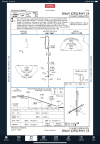
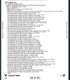
I’ve got a question for you, Russ. At my home airport, KOPL, all of the IAP’s are NA at night. This caught me out a few days back when returning after multiple approaches in actual at AEX and the conditions moved from MVFR to IFR at OPL and I just missed the daytime window by about 10 minutes. I had to divert to LFT and reposition the following morning. We are in flat land with a few radio towers well outside of the circling radii but NOTAM’ed as the lighting being INOP. Would that be the reason for having no authorization for instrument approaches at night? All other airport lighting is in great, just recently replaced, condition. Myself, and a couple of CFII’s are questioning. Thanks in advance.
IMG_0112.jpegIMG_0111.jpegIMG_0110.png
 
I’ve got a question for you, Russ. At my home airport, KOPL, all of the IAP’s are NA at night. This caught me out a few days back when returning after multiple approaches in actual at AEX and the conditions moved from MVFR to IFR at OPL and I just missed the daytime window by about 10 minutes. I had to divert to LFT and reposition the following morning. We are in flat land with a few radio towers well outside of the circling radii but NOTAM’ed as the lighting being INOP. Would that be the reason for having no authorization for instrument approaches at night? All other airport lighting is in great, just recently replaced, condition. Myself, and a couple of CFII’s are questioning. Thanks in advance.
View attachment 148864View attachment 148865View attachment 148866
take a look at the take off minimums for your airport and note all of the takeoff obstacles. I suspect you have obstacles poking into the 20:1 surface of the visual segment of the approach. Because it's hard to see those obstacles at night, the procedure is NOTAMed NA at night.

Russ, correct me if I'm wrong, it's been nearly 20 years since I took the TERPS course. IMG_0606.jpeg
 
take a look at the take off minimums for your airport and note all of the takeoff obstacles. I suspect you have obstacles poking into the 20:1 surface of the visual segment of the approach. Because it's hard to see those obstacles at night, the procedure is NOTAMed NA at night.
We thought that may be the issue. The parish government has been clearing out trees off of the approach end of 36. There is a approximately 150’ displaced threshold on 36 due to those trees. Hopefully the ‘deforestation’ may allow night instrument approaches. As of now, I will hold off of building a hangar until I see how the lack of night IFR ops effect my trips. This was the first time I had to divert to an alternate for the issue and less hangar chitter chatter before departure would have prevented it from being a problem. All of my previous night approaches at this airport had bases above the FAF/MVA so I could make a visual approach/cancel IFR safely at breakout. It will be something to consider going forward.
 
I’ve got a question for you, Russ. At my home airport, KOPL, all of the IAP’s are NA at night. This caught me out a few days back when returning after multiple approaches in actual at AEX and the conditions moved from MVFR to IFR at OPL and I just missed the daytime window by about 10 minutes. I had to divert to LFT and reposition the following morning. We are in flat land with a few radio towers well outside of the circling radii but NOTAM’ed as the lighting being INOP. Would that be the reason for having no authorization for instrument approaches at night? All other airport lighting is in great, just recently replaced, condition. Myself, and a couple of CFII’s are questioning. Thanks in advance.
View attachment 148864View attachment 148865View attachment 148866

There are a few typical reasons for procedures to be NA at night.

By far the most common is "unlit 20:1 penetrations" as @Brad Z mentions. I suspect that is the issue here. Most often, those obstacles are trees, and trees grow. (And they're rarely equipped with lights.)

Other reasons for NA at night include:
- No runway survey or an inadequate survey - if there is no survey, we have to assume there are trees that penetrate the 20:1 and therefore make it NA at night.
- No runway lights (the policy on this went back and forth a few times while I was actively designing procedures but seems to currently be that way).
- Airport request (for example for noise abatement).

When a procedure changes from available at night to NA at night, often the reason is that the airport had a new survey performed. Modern surveys are much more accurate and identify many more obstacles than previously. So the new survey gets done, and all of a sudden there are hundreds of trees reported (and of course, the trees have grown since the last survey).
 
Do I understand at this airport on approach you’d pop out at minimums and there would be obstacles you’d have to dodge to land or go missed?

You need daylight hours to see to dodge those obstacles?
 
Do I understand at this airport on approach you’d pop out at minimums and there would be obstacles you’d have to dodge to land or go missed?

You need daylight hours to see to dodge those obstacles?

"Dodge" isn't the right word.

The obstacles will usually not impede a normal, 3.0 deg glidepath to the runway, especially on centerline. But the safety margin is reduced, so if it's a bad day for your piloting performance or navigation equipment, it cuts too far into those safety margins.

There are other TERPS and non-TERPS surfaces that are also applied during airport design, which affect whether the runway can even have an approach at all.

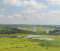
Here is a picture I took on an inspection of some trees which had grown and penetrated the 20:1, you can see what I mean. We are on a 3.0 deg glidepath. A "normal" approach wouldn't have you dodging anything, but at night it would be concerning. For this one, I NOTAMed it NA at night and also made LPV and LNAV/VNAV DA NA, since those trees also penetrate the applicable surfaces for vertically guided procedures.

You can tell there was a tree-clearing effort years ago (I believe it was in about 2013), and the airport manager confirmed that. He was aware of the tree growth and was trying to get approval or funding (etc.) to do another tree-clearing project. Until they do, though, this is not an approach you want to fly at night (or to minimums on LPV or LNAV/VNAV).

1767999652174.png
 
Last edited:
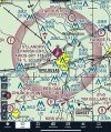
Russ, my home airport, KOPL (St. Landry Parish, Opelousas, LA) has not had a night authorized instrument approach for some time. Trees have been cleared from one approach end, new lighting installed, etc. I was told by mgmt., about 6 mos back, that they didn't have the funds for a flight check and had no idea when that may happen. A couple of days ago, one of my hangar mates (a Titan Fuels T6 aerobatic team member...so should be 'in the know'), said that a fliight check was recently performed and the NOTAM should come down soon. As of today, night IA's are still NA in NOTAMS. Any sugestions on where to inquire, within the FAA databases, to see the progress on removing the night restriction?
 
Russ, my home airport, KOPL (St. Landry Parish, Opelousas, LA) has not had a night authorized instrument approach for some time. Trees have been cleared from one approach end, new lighting installed, etc. I was told by mgmt., about 6 mos back, that they didn't have the funds for a flight check and had no idea when that may happen. A couple of days ago, one of my hangar mates (a Titan Fuels T6 aerobatic team member...so should be 'in the know'), said that a fliight check was recently performed and the NOTAM should come down soon. As of today, night IA's are still NA in NOTAMS. Any sugestions on where to inquire, within the FAA databases, to see the progress on removing the night restriction?
Pretty much the answer to any question like that is the FAA's IFP Gateway, which provides status updates (although typically not as detailed as you might like) and contact information to ask questions.

If you search for KOPL on there, then go to the IFP Production Plan tab, you will see that a new RNAV approach for both RW 18 and 36 is due to be published on 10/29. The IFP Coordination tab shows the paperwork and documentation for each approach, including a "FIG" which is the prototype graphic (and an opportunity to comment on the procedure, although that window ended on 8/6). There is also an entry for "NIGHTEVAL" which is, well, the Night Evaluation for that airport. The second (and subsequent) pages of the second file listed there shows that the night eval was completed on 8/20.

I see the NA at night NOTAM is still active. Without reviewing all of the changes involved on each of these procedures, I can't say with any certainty whether that NOTAM will be canceled soon or if it will wait until the new procedures are published. However, I strongly suspect that the NOTAM will be canceled on 10/29. Although that's certainly a question you could ask through that website.

Hope this helps!
 
@RussR YES!!! That is very helpful and just the information I am interested in. Hopefully we will once again have night approaches. I have been hindered by the lack on a couple of occasions and had to land at LFT then move the plane the next day. I appreciate your expertise and your time devoted to this thread.
 
Last edited:
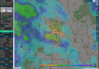
Russ, what is FLC90 doing today near LEB?
 

Attachments

  • Screenshot 2026-09-09 142344.png
    Screenshot 2026-09-09 142344.png
    4 MB · Views: 20
What's the height of the Linden VOR?
 
Russ, what is FLC90 doing today near LEB?

I'm on leave so can't look up the exact task, but from the ground track that looks like an ILS commissioing-type inspection.to runway 18. Since there is already an ILS to that runway, that means there was likely a major change to the ILS antennas or transmitters (or possibly a major repair due to damage).

The arcs you see are across the localizer, flown at constant altitude, testing such things as localizer course width, signal strength, modulation and other factors at various distances. The holding patterns are flown at constant altitude and are testing similar parameters for the glideslope ("vertical" width essentially since at a constant altitude the glideslope will go from full scale fly-up to full scale fly-down). Then there will be several runs down final as well.
 
Was this covered?

You are testing the navaids to ensure the aircraft is where the cockpit indications say the aircraft is, for much of the testing, yes?
What is used to compare those cockpit indications to? ie what is the standard that is used?

For an ils, is it gps position?
What about a gps approach not associated with any ground-based navaids for comparison - maybe you have a second high accuracy gps unit?

Thanks
It's all GPS these days. We have multiple GPS units on board and multiple IRUs (not that these would provide anything more than a rough error check if something looked really wonky).

The GPS position is considered to be correct, unless we get some evidence to the contrary - but that would be indicated by things such as RAIM alert or WAAS downgrade. So on a GPS approach, we aren't really checking the GPS signal itself, it's assumed to be good. We're checking the FMS coding of the procedure, the sequencing between waypoints, obstacle clearance, missed approach sequencing, holding pattern size and direction, lighting systems, circling obstacle, and overall flyability of the procedure.

We're also checking that the runway is where the data says it is, by flying over each end at 50 ft and comparing that to the published coordinates. If I can find it when I get home, I'll try to post a video of a case where we found the runway coordinates were off, and so the procedure as designed was supposed to be straight-in but came in at a bit of an angle.

I guess I always envisioned the back of the airplane having a bunch of oscilloscopes and a mad scientist technician monitoring the raw signal data as you test flew the NAVAIDs?
 
I guess I always envisioned the back of the airplane having a bunch of oscilloscopes and a mad scientist technician monitoring the raw signal data as you test flew the NAVAIDs?
Pretty accurate. There are signal displays and a bunch of receivers back there. We also consider our mission specialists somewhat of a mad scientist, so that's pretty accurate too.
 
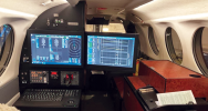
This (from Google image search) is our mission specialist station in the King Air, with some typical signal depictions on it. The right monitor slides to the left when not in use (to keep the aisle clear).

The enclosures on the right side, where seats would be, are equipment racks holding all the receivers.
 

Attachments

  • 1_LiKyHwICvmzI_F6PV2eEqA.png
    1_LiKyHwICvmzI_F6PV2eEqA.png
    1.4 MB · Views: 19
This (from Google image search) is our mission specialist station in the King Air, with some typical signal depictions on it. The right monitor slides to the left when not in use (to keep the aisle clear).

The enclosures on the right side, where seats would be, are equipment racks holding all the receivers.

What is typical crew staffing on the King Air. Just pilot and specialist, or two pilot crew, etc.?

Obviously all of the jets you use are two pilot required.
 
What is typical crew staffing on the King Air. Just pilot and specialist, or two pilot crew, etc.?

Obviously all of the jets you use are two pilot required.
We always operate with two pilots. There's just way too much to do and pay attention to for one. One mission specialist, unless one is in training, then we will have a mission specialist instructor on board too.
 
It's all GPS these days. We have multiple GPS units on board and multiple IRUs (not that these would provide anything more than a rough error check if something looked really wonky).

The GPS position is considered to be correct, unless we get some evidence to the contrary - but that would be indicated by things such as RAIM alert or WAAS downgrade. So on a GPS approach, we aren't really checking the GPS signal itself, it's assumed to be good. We're checking the FMS coding of the procedure, the sequencing between waypoints, obstacle clearance, missed approach sequencing, holding pattern size and direction, lighting systems, circling obstacle, and overall flyability of the procedure.

We're also checking that the runway is where the data says it is, by flying over each end at 50 ft and comparing that to the published coordinates. If I can find it when I get home, I'll try to post a video of a case where we found the runway coordinates were off, and so the procedure as designed was supposed to be straight-in but came in at a bit of an angle.
i don’t know how you guys do all that and watch for traffic!
 
@RussR The new RNAV approaches at KOPL, removing the NA at night restriction, finally made it into the published charts. Yayyyy!!! Thanks for your input on the process.
 
Back
Top