FAA "Flight Check" pilot - ask me anything

ln the early 80's I bumped into a guy in the check-in line at Heathrow carrying a helmet bag. I was stationed at RAF Upper Heyford at the time and was going home on leave. I noticed a F-100 painted with an N Number parked on the ramp at Heyford as I was leaving. Turns out he was the pilot of the F-100 and he flew for a company contracted by the USAF to check instrument approaches at military fields. The plane was broke so he was returning to the states. It looked like a pretty neat gig for a retired military aviator.
 
I’m thinking you can claim “most iaps conducted” of all pilots, all aircraft, in this country, ever.

No idea about that Guinness Record ;), but I will say that my Foreflight Plates Binder for next week has 37 charts in it, and that's not including any we might need just for normal flying purposes getting to and from our work areas. Some of those we will fly multiple times.

Of course it's (almost) all VFR, so nothing counts for anything, but I would agree we are very proficient in operating the FMS and the aircraft.

I wonder if there is something powerful there that could be shared with us average users of the system.
I’m sure you have nailed down all your entries to procedures, configurations, airspeeds, button pushing to an exact science - and have handled enough unusual occurrences (conflicting traffic, equipment drop-outs maybe?) that you could teach us a thing or two.

I don't think it's really any different than what I teach my instrument students, although of course we have thousands of reps to build that procedural memory. Power-Attitude-Configuration is the name of the game in any instrument flying, be it Challengers or Cessnas.

For example, for the King Air, I set fuel flow to 300 pounds a side for most operations*. That gives us 160 kias or so, which is a good speed for a lot of our maneuvers. If I'm flying an inspection approach, I still set 300 a side, then flaps to approach at two dots below the glidepath, and gear down at one dot below. The added drag slows us to 140 or so, which is a typical flight inspection approach speed (since we know we're going to be a low approach, we just stay faster than a King Air would normally, unless traffic requires slowing). If we're actually landing, then it will be flaps full down, which slows us to about 120, which is within spitting distance of our Vref, which is usually about 100-103 depending on weight. It's likely I haven't touched the power until this point.

We do get a ton of reps on the FMS (Collins Pro Line 21 in the King Air and Pro Line Advanced in the Challenger), and use far more functions than most pilot ever will have a need to. That familiarity makes recurrent training so much easier, as our focus can be on the scenario at the time, not the box programming.

* Why fuel flow versus power setting? There's no magic here, some people do use power setting. But for our operation, we are usually operating at about the same weight, so power setting does give us a pretty consistent speed, and the speed itself isn't really the important thing. What setting a nice round number like 300/side does is give us a pretty easy calculation of how much fuel we have remaining in time. Each big tick mark on the fuel gauges (100 pounds) is 20 minutes. Since out purpose is not to actually get anywhere (hah), but to get the tasks complete, and some take longer than others, the FMS calculation of fuel at our ultimate destination is almost a meaningless number until we finish this task and head that way. We often have to tell the ground techs "we have 45 more minutes for you to try to make adjustments, then we have to go get gas". In that regard it's not really any different than an airliner in holding.
 
Maybe I missed this:

What’s the most common thing you find? New obstacles (trees, towers, …)? Misalignment in a localizer or g/s?
 
We do get a ton of reps on the FMS (Collins Pro Line 21 in the King Air and Pro Line Advanced in the Challenger), and use far more functions than most pilot ever will have a need to. That familiarity makes recurrent training so much easier, as our focus can be on the scenario at the time, not the box programming.
Can you think of any specific FMS functions that you think the average instrument pilot doesn’t use but would be wise to learn, either because they are handy on every flight or because they would be handy in a specific emergency scenario?
 
Maybe I missed this:

What’s the most common thing you find? New obstacles (trees, towers, …)? Misalignment in a localizer or g/s?
New obstacles (that are actually a factor) are really pretty rare. The notification and filing procedures for new construction, and the obstacle database used for procedure design seems pretty good from our standpoint.

I'd say by far the most common issue we find on a routine, periodic inspection is with PAPI lights. Either they're labeled pilot-control on the chart and don't come on, or they're on but a light is burnt out, or the mower ran into one of the boxes and it's misaligned, etc. I've seen where a clump of grass blocked the view of the outer light, and I've seen where the inner two lights of a 4-light PAPI sequenced from red to white simultaneously. A couple weeks ago the chart showed a VASI, but there was a NOTAM that the VASI was out of service, but when we got to the airport there was a nice looking PAPI turned on that we had no data on. Stuff like that.

It's also pretty common for the localizer or glideslope to need some kind of adjustment. None of these adjustments would be something that you as the pilot would ever notice, because the tolerances we're inspecting have a lot of buffer from what would ever be an issue on an actual approach. Width of the localizer course, width (vertical) of the glideslope, signal strength, various modulation levels and such. So we fix them before they DO become a problem.
 
Can you think of any specific FMS functions that you think the average instrument pilot doesn’t use but would be wise to learn, either because they are handy on every flight or because they would be handy in a specific emergency scenario?

The advanced FMS functions that we use are generally not something that would be used (or useful for) the average instrument pilot. Stuff like manually entering lat/long coordinates to define something (a point, obstacle, new DME antenna location, etc.). Constructing bearing lines off fixes for alignment and/or situational awareness purposes. Circles of various radii around fixes. Custom database selections like "fly an arc 10 nm from the localizer antenna from 40 degrees left to 40 degree right of course".

When we're flying normal enroute stuff and actual approaches, we use the normal functionality of the FMS like anybody else would.
 
Or maybe its like our PAPI that has a mediocre foundation and has been sinking. They are redoing it in a few weeks and giving it a good base
 
Can you think of any specific FMS functions that you think the average instrument pilot doesn’t use but would be wise to learn, either because they are handy on every flight or because they would be handy in a specific emergency scenario?
Judging by the questions I see on Garmin user forums, VNAV is probably the most asked about/misunderstood feature.
 
Judging by the questions I see on Garmin user forums, VNAV is probably the most asked about/misunderstood feature.
That's probably right. I flew with a client just today and covered most of the important VNAV functions on the GTN650 - how to set it up, set the desired descent rate, VNAV-direct, pilot-discretion descent, etc. Combining that VNAV descent with an approach clearance, he was pretty impressed that you pretty much don't have to do anything else all the way to the ground if you have it set up right.
 
Judging by the questions I see on Garmin user forums, VNAV is probably the most asked about/misunderstood feature.
Definitely. But that's mostly about people trying to teach themselves. Pretty smuch the same stuff as teaching oneself any modern avionics. #1 on the VNAV hit parade is understanding the need to have (1) an altitude constraint in the flight plan and (2) a selected altitude at or below your VNAV target. But another part of the problem with DIY VNAV in the terminal area is that there are three variations depending on both the type and age of the equipment (the need, or not, to arm within 5 NM of TOD, but not too close!), and difference between "transition to approach" being on or off.

That's aside from pilots trying to use it with a GNS series navigator and the unfortunate issue that a lot of VNAV (such as "Transition to Approach" is described in the navigator manuals rather than the autopilot manual.
 
Last edited:
Can you think of any specific FMS functions that you think the average instrument pilot doesn’t use but would be wise to learn, either because they are handy on every flight or because they would be handy in a specific emergency scenario?
I've posted it before, but here's the list I bring out for transition training, recurrent training, and IPCs. Problem is that these are all real tasks that come up and most of the errors I see are basics, not advanced FMS functions.

1751807784775.png
 
Last edited:
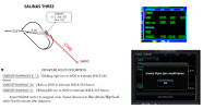
Russ, I have a coding one that might or might not be in your ballpark. It's more about the database coding of a SID. The question came up in an Avidyne Facebook group. It involves the KSNS SALINAS THREE SID. This is a snip of the SID. For context, I added the location of V248 (red) which has a terminus at SNA VOR. IOW, from SNS it only goes SE, no NW extension for example.

The clearance is SALINAS THREE, SARDO. After the westbound departure, the the pilot is untimely given a vector to "intercept V248." Should be simple. At the end of the SID manual/vector segment, add SNS again and the airway to SARDO. But the poster said they were not able to enter SNS the second time. No warnings; The IFD just would not accept the second SNS. I was able to confirm this behavior in the Avidyne simulator.

Even an old Garmin GNS will do it, although without entering the airway by name. In that one just enter SNS - SARDO (shown) and activate the leg. So I figured it was some Avidyne issue. Until I tried it in a GTNxi. There I found similar behavior. Any attempt to add SNS the second time, resulted in an "invalid" annunciation. In the photo I tried to add it before SARDO, but I also tried it without SARDO, and using both the Garmin and Jepp database.

So no V248 and no SNS-SARDO leg to intercept.

Of course, one can do it using VOR and if I have the habit of loading VORs as backup, it's not that hard. And there's a way or two to do it GPS (including OBS to SARDO), although I'm not sure either would come to mind in the air after the "Huh?!" about not being able to load SNS as the first enroute waypoint.

But idea why this might be happening?

1751814769963.png
 
Last edited:
I delivered the first (I think) 605 to OKC, and I recall talking to one of the FAA guys there and they said the airplanes were going to be able to be used for other things like flying people around. Did that end up happening, and if so how has it worked out?
 
I flew a flight check once in Kosovo. Didn’t even know we had a flight check branch in the Army. Picked up a CW5 at Skopje who just flew in on a UC-35. Got in the back of the aircraft and we flew him to Bondsteel to flight check our PAR. All he had in the back was a laptop and a big antenna sticking up. Probably not IAW our PED regs but whatever. Did a couple of approaches and he was done. Flew him back to Skopje, he hoped in the UC-35 and flew back to Germany. Think he said we were good for another two years.
 
I delivered the first (I think) 605 to OKC, and I recall talking to one of the FAA guys there and they said the airplanes were going to be able to be used for other things like flying people around. Did that end up happening, and if so how has it worked out?
Yes. The 605s are used in a dual capacity - flight inspection and transportation. For example, the FAA has long had the "contract" to fly the NTSB go-team to aircraft accidents. While different aircraft have been used in the part for this, this mission is now performed by the 605s. Other government agencies/officials as well.
 
Russ, I have a coding one that might or might not be in your ballpark. It's more about the database coding of a SID. The question came up in an Avidyne Facebook group. It involves the KSNS SALINAS THREE SID. This is a snip of the SID. For context, I added the location of V248 (red) which has a terminus at SNA VOR. IOW, from SNS it only goes SE, no NW extension for example.

The clearance is SALINAS THREE, SARDO. After the westbound departure, the the pilot is untimely given a vector to "intercept V248." Should be simple. At the end of the SID manual/vector segment, add SNS again and the airway to SARDO. But the poster said they were not able to enter SNS the second time. No warnings; The IFD just would not accept the second SNS. I was able to confirm this behavior in the Avidyne simulator.

Even an old Garmin GNS will do it, although without entering the airway by name. In that one just enter SNS - SARDO (shown) and activate the leg. So I figured it was some Avidyne issue. Until I tried it in a GTNxi. There I found similar behavior. Any attempt to add SNS the second time, resulted in an "invalid" annunciation. In the photo I tried to add it before SARDO, but I also tried it without SARDO, and using both the Garmin and Jepp database.

So no V248 and no SNS-SARDO leg to intercept.

Of course, one can do it using VOR and if I have the habit of loading VORs as backup, it's not that hard. And there's a way or two to do it GPS (including OBS to SARDO), although I'm not sure either would come to mind in the air after the "Huh?!" about not being able to load SNS as the first enroute waypoint.

But idea why this might be happening?

View attachment 142597

I have absolutely no idea why that wouldn't work. That's probably what I would try too. Sorry, definitely not in my area of expertise.

Sounds like maybe a @John Collins question to me!
 
I have absolutely no idea why that wouldn't work. That's probably what I would try too. Sorry, definitely not in my area of expertise.

Sounds like maybe a @John Collins question to me!
I figured it might not be in your department, but I figured you said “anything.” :D
 
My wife says if I don’t know, I just make something up and sound convincing.

a guy at work didn't seem to understand the long-term ramifications of making up answers when he didn't have an f'n clue.
 
Monday and Tuesday went mostly well, we headed out from OKC and inspected the ILS 36C at MEM yesterday and had to make some adjustments, so it took longer than expected and we had to finish up after fuel stop/lunch break. After that we headed up to the NE near MKL to fly a 70 nm partial orbit around the GQE VOR, to evaluate its use for VOR MON in the section from R-077 CCW R-020. We got to about R-050 before we had to discontinue it due to weather. We were scheduled to fly a procedure amendment at JBR as well but postponed that due to weather too.

Today we inspected the ILS 18C at MEM (which only needed a few adjustments) then wanted to finish up the GQE arc, but we could see on the ADS-B radar that storms were right where we needed to be, so instead we headed to JBR to inspect that procedure amendment, then back to NQA for fuel and lunch. (Pretty good lunch at the Pig-N-Whistle in Millington, TN, by the way.) After lunch we were supposed to go up to BVX to inspect their Localizer, but weather was bad over that way so we canceled that (to be rescheduled at some later time), but saw that the weather looked possible for finishing the GQE orbit segment. We were able to finish that with some weather deviations then back to MEM for overnight, we got in just before the storms rolled through.

A fairly typical couple of days so far - weather issues, facility issues, schedule changes. It's important to be flexible.
 
Well to be fair, while I had more GCA experience than anyone in the radar room, the MATCALS PAR (page 5) was pretty darn accurate. It was state of the art back in the 80s but they got rid of it in 2014.

One thing I was wondering about. I seem to recall in Thailand they were checking our TACAN, PAR and SA but don’t you all check radar coverage as well? I seem to remember that in order to chart our MVAs we needed confirmation that the Flight Check was still under radar coverage.

When I was at Nam Phong they did a commissioning flight check when MATCU-62 got there in 72. The Air Force did it in a C-140
 
Yes. The 605s are used in a dual capacity - flight inspection and transportation. For example, the FAA has long had the "contract" to fly the NTSB go-team to aircraft accidents. While different aircraft have been used in the part for this, this mission is now performed by the 605s. Other government agencies/officials as well.

Do they take the electronics out of the back, or is it compact enough that it doesn't bother the pax?
 
… inspected the ILS 36C at MEM yesterday and had to make some adjustments, …
You said this a couple of times. Is the GIB talking to a tech on the ground that fiddles with the diddle or done remotely by the GIB or done some other way?
 
Do they take the electronics out of the back, or is it compact enough that it doesn't bother the pax?

The "newer" 605s are being outfitted with a new flight inspection package, which is much smaller than the "racks of equipment" in the past (meaning current). This equipment essentially occupies about one seating position, mounted on the seat rails, and the operator sits in one of the regular seats to operate it. Picture a big box with a computer keyboard and screen on one end. It is removable if that extra seat space is needed, or can just sit there mostly out of the way if the remaining seats are enough.
 
Last edited:
You said this a couple of times. Is the GIB talking to a tech on the ground that fiddles with the diddle or done remotely by the GIB or done some other way?
Talking to techs on the ground. We don't want the GIB fiddling with his diddle in the airplane, thank you very much.

During (almost all) ILS inspections, the ground techs are there primarily to take the localizer and glideslope in and out of various "alarm" configurations, intentionally de-tuning and de-phasing certain components and antennas as we make repeated passes, to see if the signal still meets tolerances even in a de-tuned state. Then if adjustments are needed, our tech and the ground techs work together on how much they need to adjust it, etc.

During a flight inspection, the ILS will be NOTAMed off the air because the configurations we put it in are not necessarily safely flyable.
 
You mentioned that your procedures result in the gear and flaps being cycled more frequently than they would be in normal flight operations. Are there other maintenance peculiarities to these aircraft, and are there plans, concerns, or a desire to replace any of the aircraft (specific N-numbers or even all of one type) currently in service?
 
You mentioned that your procedures result in the gear and flaps being cycled more frequently than they would be in normal flight operations. Are there other maintenance peculiarities to these aircraft, and are there plans, concerns, or a desire to replace any of the aircraft (specific N-numbers or even all of one type) currently in service?
Yes. We are replacing all of the King Air 300s with new King Air 360ER's starting later this year, a couple at a time. I believe the contract with Beechcraft is for 18 new ones over the next few years. We do have some common recurring maintenance issues just due to age. Typically it's not stuff like the gear or flaps, I guess those are inspected pretty closely, but auxiliary stuff like the air conditioning, or various controls and sensors. For example, today it took a long time for the left bleed air light to come on during the pre-taxi checks, meaning something is probably going to need to be replaced soon.

But the aircraft see some kind of maintenance action just about every week after an itinerary.
 
When I was at Nam Phong they did a commissioning flight check when MATCU-62 got there in 72. The Air Force did it in a C-140
We had a pre flight check done with our local “Sumo” C-130 followed by an FAA flight check a couple days later with a CL600. I hitched a ride in both of them as kind of a “liaison” to observe the process.
 
FLC80 (King Air) was at KRYY today. Got a clearance up to 9A4.
 
FLC80 (King Air) was at KRYY today. Got a clearance up to 9A4.

They have a base there. Could have been a friend of mine.

Correct. The hangar and offices are at the north end of the ramp located behind the control tower.

Our bases are RYY (Atlanta), ACY (Atlantic City), OKC (Oklahoma City), BTL (Battle Creek, MI), and SMF (Sacramento).
 
A tough day today. Our inspection of the MEM ILS RWY 36R took longer than expected. They had replaced the localizer shack and the DME with a new system, and additional runs were called for as a result. Plus both the glideslope and localizer needed multiple adjustments, so it ended up taking all morning.

After fuel and lunch we headed up to 4M9, Corning Muni, AR, to commission a new set of PAPI lights for each end of the runway, and new REILS as well. The REILS don't require much, just looking at them to make sure they work, are visible from the required angles, and don't blend in with other lights. But the PAPI commissionings, as a pilot is one of the most fun checks we do. First we fly about 500 AGL on final, level, and watch the lights transition from red to white, marking the angle at which they do so. Then do some math to get the average angle, which has to be within 0.20 degrees of the commissioned value, in this case (and most cases) 3.00 deg. We do two runs on each side to ensure a consistent reading, since this is largely a manual, eyesight/reaction time kind of test. One runway needed some adjustment to the boxes (after which we flew it another two times to verify), but the other side was good. We then fly from side to side across final to ensure the PAPIs are visible at least 10 degrees either side of centerline (the service volume of a PAPI). Lastly is a below-path run, where we intentionally fly down final lower than normal, with all red lights showing on the PAPI, aiming at the highest terrain/obstacle/tree/whatever to ensure we can still clear it while seeing all red lights. That ensures that if you have at least one white light, you won't hit anything. We may weave from side to side down final, or do multiple passes, to try to cover the full 10 deg width on either side of centerline. So it's low altitude, definitely requires heads-up flying, and is quite fun too. 4M9 passed that with no problems, there are not a lot of obstacles out there (and no terrain).

After that, over to EIW, New Madrid, MO for a periodic inspection of their two RNAV approaches. Nothing to report there, no new obstacles and the lighting system worked fine, came up with the mic clicks and the lights all worked.

Back to MEM for the night!
 
When a new approach is made, does the airport have to pay for the flight check to certify it or does the FAA fund it?
 
When a new approach is made, does the airport have to pay for the flight check to certify it or does the FAA fund it?
That's outside of my area of expertise, and I hesitate to answer because I don't know all the details, and would certainly get too many of them wrong. I do know that some things are funded by the FAA, and some things are funded by the airport. But I couldn't tell you anything reliable about the division between the two.

There are some people on this board who know far more about this topic than I do.

We just had a new RNAV(GPS) approach published for our airport. We put in the request with the FAA about 8 years ago, had to go through a justification process, and finally got it. The FAA funded the flight check and published the approach all on their dime. The only hiccup is there is no record of our runway edge lighting ever being officially flight checked and commissioned, so the new approach is NA at night until we can setup the reimbursement agreement and funding for that flight check. Yes the airport is having to pay @RussR to fly his King Air here and fly down the runway to make sure the runway lights are properly functioning.
 
A tough day today. Our inspection of the MEM ILS RWY 36R took longer than expected. …
Do y’all have duty limits? For example, on the E-3 we had a 14-hr duty day waiverable to 16, 90hrs/30day look back limit, and 360 (I think, maybe a little less) over 90 days. Standard 12/8 crew rest.

If you broke any if them it was a admin grounding until the hours fell off. I only broke that once, early during OEF and we’d had our 90 day look back waived to 400hrs. I hit that mark about 2.5 months in and got sat down for about two weeks. I didn’t realize how beat I was until after the first week of that grounding had passed.
 
Back
Top