TK211X
Pre-takeoff checklist
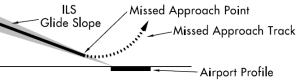
Ok, so from what I understand for a precision approach we have our minimums DH/DA and non precision approach we have an MDA.
As I understand......
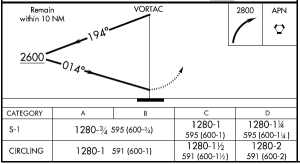
Left side digits = (DA) and that's MSL
Right side smaller digits = (DH) and that's AGL
I was looking at the king course and when explaining a precision approach Martha pointed to the digits and identified them as stated above. However in the next video she says for a precision approach your altitude is a "Decision Height" and for a non precision approach you have a MDA.
That confused me a bit, but I feel like saying that myself when looking at those numbers myself at a glance. Was she referring to decision height as a blanket term or was she referencing the DH/AGL?
Also and So.... reaching DH/DA marks your MAP. However for a MDA you determine your MAP by NAV reference?
Just wanted someone to clarify - Thanks in advance.
As I understand......
Left side digits = (DA) and that's MSL
Right side smaller digits = (DH) and that's AGL
I was looking at the king course and when explaining a precision approach Martha pointed to the digits and identified them as stated above. However in the next video she says for a precision approach your altitude is a "Decision Height" and for a non precision approach you have a MDA.
That confused me a bit, but I feel like saying that myself when looking at those numbers myself at a glance. Was she referring to decision height as a blanket term or was she referencing the DH/AGL?
Also and So.... reaching DH/DA marks your MAP. However for a MDA you determine your MAP by NAV reference?
Just wanted someone to clarify - Thanks in advance.