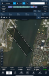
What? Airplane 272’agl, helo route 200’agl? So, someone was planning a crash?
I have been trying to get this point across throughout this thread but apparently I have repeatedly failed.
Minimum vertical separation is 500'. Having a helicopter pass under an airplane on Final to Rwy 33 is NOT acceptable. Vertical separation can NOT be applied in this situation. You either have visual separation or you delay the helicopter from crossing the final until no airplanes will be there.
The briefer ducked the question as to what the ATC screen display read of the RJ's altitude, and how or why that may have differed from the aircrafts confirmed altitude.
...
begging the question as to why the ATC radar was reading at least 100' low.
It was addressed. The radar update time is every 4 to 5 seconds so what the controller sees is always from a few seconds ago. Also, the altitude reporting system does not have the level of precision to display indicated altitude (what the pilot is flying) to within 100' or 200'. That why the absolute minimum vertical separating that can be applied by radar is 500'.
TA happens 18 seconds prior to collision
TA's are programming to alert when 40 seconds from the closest point of approach. That calculation is done based on the current rates of closure. That rate changes as an aircraft turns or maneuvers.
An inconsistency from the press conference was that he said that there was an aural TA alert AFTER the 500' call-out. The aural alert is suppressed below 500' RA and the 500' call is also based on RA. Did TCAS give an aural alert when it should have been suppressed or was he incorrect that the TA was aural vs. just displayed? I don't know.
Also they brought up another point, IMO VHF should be mandatory outside of military only airspace in CONUS, would be a great benefit to SA
Even if the helicopter was on VHF, he would have been on the helicopter VHF frequency (134.35), not the one used for airplanes (119.1).
is there any chance the RJ was a little low
Yes. We are always bracketing when tracking a glideslope, glidepath, or PAPI.
Is 125' deconfliction actually correct. That seems nuts, especially on a bumpy day.
Minimum vertical separation is 500'. Having a helicopter pass under an airplane on Final to Rwy 33 is NOT acceptable. Vertical separation can NOT be applied in this situation. You either have visual separation or you delay the helicopter from crossing the final until no airplanes will be there.
I've wondered about this. What was the barometer at the time? Could it be that the helo was at 200' pressure altitude and ~300' true altitude?
It's not about True Altitude because none of the altimeters in any of the aircraft are capable of displaying True Altitude. It is about Indicated Altitude.
The ATC radar system receives pressure altitude, to the nearest 100' (Mode-C), 50' (Mode-S), or 25' (ADSB-OUT) and corrects it for the local altimeter setting.
A perfect altimeter, with the local altimeter setting set perfectly, will display True Altitude only when on the ground at the reporting station. Any deviations from that and your indicated altitude will differ somewhat from True Altitude.
Don't attribute more precision to the displayed altitudes than the overall altimetry system is capable of producing.
The helo should have had his barometric altimeter set at field elevation at the last place landed.
No. Both aircraft should have been set to the altimeter setting from the current DCA ATIS. That is another source of error in the altitude readings.
So....they weren't cleared for a visual approach? or were they following the plate?
They were cleared for the MT VERNON VISUAL charted visual procedure. They were then switched to a visual (non-charted) to Rwy 33.