Class G and E airspace

Almost all of the "high" class G airspace has been eliminated by airspace changes through the regulatory process completed during the last 12 months. The remaining few areas are slated for regulation changes. Class G above 1200 AGL in the CONUS is for the most part a memory.
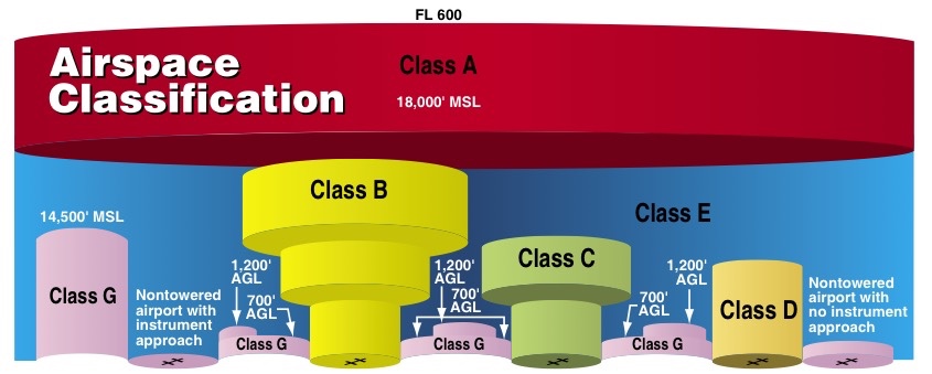
Yes. It's probaby, for practical puropsess, better to say Class G goes up to 1200 AGL unless a different altitude is depicted.
 
I would think of E-down-to-1,200 as the default.
But it isn't the default. The default is Class E starting at 14,500'. It is lower only where it has been established to be lower or a higher-class of airspace has been established.
 
But it isn't the default. The default is Class E starting at 14,500'. It is lower only where it has been established to be lower or a higher-class of airspace has been established.
You are correct if you want the answer to a knowledge test. But it's hard to say 2% is the default and 90% of what you see on any sectional chart is the exception. Those probably aren't the right numbers - Class G to 14,500 is probaby zero to a fraction of a percent on any random sectional you might pull out, but close enough.
 
Why am I an idiot?

When does class G extend all the way up to 14.5k? I get class G can go up to 700agl if the magenta line is around an uncontrolled airport. What I don't understand is when class G goes up to 1200 agl and when it goes all the way up.

Do you all have any ideas on how I can keep this straight?

It's not that Class G airspace extends up to 700' AGL or 1200' AGL. Class G airspace exists where controlled airspace has not been established. You can see an example here. The blue vignette indicates Class E airspace begins at 1200' AGL outside of the polygon and at 14,500' MSL inside of it. On low altitude enroute IFR charts brown shading is used to indicate Class G airspace below 14,500' MSL.
 
If there is, it's reasonably new. The old Continental Control Area started at 14,500 and went to infinity. The old Positive Control Area, now Class A, was from 18,000 to 60,000.
It's not new at all, it exists where high terrain pushes the floor up. Class A airspace above 18,000 MSL does not include the airspace less than 1,500 feet above the surface. The highest point in Alaska is Mount Denali at 20,310' MSL.
 
Not new. Class A and E exclude areas lower than 1200 AGL. There is at least one high mountain over 18000 and several over 14000.

Class A airspace excludes areas lower than 1500' AGL. Class E airspace can begin at the surface.
 
Don't forget Alaska. Denali is 20,322' so up to 21822' is class E by FAR.

No, it's Class G up to 21,822' MSL. Class E exists over Alaska from 14,500' MSL and up except for the Alaska peninsula west of 160 degrees west longitude and airspace below 1500' AGL.
 
Last edited:
But it's hard to say 2% is the default and 90% of what you see on any sectional chart is the exception.
But that's exactly what it is and what we should teach our students. The north/south strip of Class E floor at 14,500' just east of the Grand Canyon is a good example which shows that it is the 1200' AGL Class E floor which is different from the default. Lots of it to be found in Alaska as well.

Most of the planet is covered with uncontrolled airspace above 1200' AGL. Aviation is a worldwide activity.
I've even operated from an airport where the floor of controlled airspace in the area is FL245 (in a civilian transport jet under part 121).

My point, though, is that for new pilots to understand the airspace structure they must understand it from the ground up, so to speak. They need to understand the hierarchy from uncontrolled up through the higher classes. Everything starts as uncontrolled then we start adding controlled airspace which supersedes the Class G. Once they've learned that they go can anywhere in the world and understand the local airspace.
 
I have a more generic Class G question. I know it's not controlled airspace, but can a private pilot legally fly at whatever altitude AGL they want in class G?
Reason I ask, is I noticed over the weekend a plane circling above my neighborhood. It was fairly obvious either the pilot or his passengers lived in our hood and wanted to look at their house, but I would estimate he was only 500' or so above the ground which was significantly below the Class E floor of 1200'.

I guess on a broader scale, what is the purpose of Class G space being different than Class E space outside of airports? Is it simply so they can have different visibility requirements.
I think I have a decent understanding of identifying where Class G airspace is, but I'm confused as to the purpose of it in comparison to Class E space If you can fly wherever you want in Class E or Class G.
 
I have a more generic Class G question. I know it's not controlled airspace, but can a private pilot legally fly at whatever altitude AGL they want in class G?
Reason I ask, is I noticed over the weekend a plane circling above my neighborhood. It was fairly obvious either the pilot or his passengers lived in our hood and wanted to look at their house, but I would estimate he was only 500' or so above the ground which was significantly below the Class E floor of 1200'.

91.119 "minimum safe altitudes" still applies. It makes no reference to class of airspace.
 
91.119 "minimum safe altitudes" still applies. It makes no reference to class of airspace.

Excellent, thanks for sharing that.
Looks like the guy over my neighborhood was likely in violation of this rule because he was clearly way below 1000'. Not to mention we have fairly large power line towers half a mile from the neighborhood which would require him to be another ~200' or so higher than 1000'.

So is the Class E/G more about weather visibility minimums?
 
Why am I an idiot?

When does class G extend all the way up to 14.5k? I get class G can go up to 700agl if the magenta line is around an uncontrolled airport. What I don't understand is when class G goes up to 1200 agl and when it goes all the way up.

Do you all have any ideas on how I can keep this straight?
5b18c70098623bda05bb29e3ed8a79a3.jpg


Sent from my iPad using Tapatalk

Try looking at it from the top down. Start out with the baseline that everything above 14500 is controlled airspace and everything below is uncontrolled airspace, Class G. Now just look to see where controlled airspace is taken lower. The blue goes down to 1200, the magenta goes down to 700 and the Surface areas go to the surface. B's and C's are easy enough to figure out, the numbers are right there. There are of course the areas where the floor of E is other than 1200 or 700, the numbers are right there on the Chart. Give it a try and see If visualizing it from the top downwards helps.
 
I have a more generic Class G question. I know it's not controlled airspace, but can a private pilot legally fly at whatever altitude AGL they want in class G?

No, FARs 91.119 Minimum safe altitudes: General and 91.159 VFR cruising altitude or flight level apply in Class G airspace.

Reason I ask, is I noticed over the weekend a plane circling above my neighborhood. It was fairly obvious either the pilot or his passengers lived in our hood and wanted to look at their house, but I would estimate he was only 500' or so above the ground which was significantly below the Class E floor of 1200'.

That would violate FAR 91.119, the class of airspace is irrelevant.
 
That would violate FAR 91.119, the class of airspace is irrelevant.

Why would it violate 91.119? Do we know for a fact that the area where the house was was "congested"? If it was sparsely populated, 500' is actually fine.
 
Why would it violate 91.119? Do we know for a fact that the area where the house was was "congested"? If it was sparsely populated, 500' is actually fine.

I'll go out on a limb and say that it isn't considered sparsely populated. Attached a picture of my hood in suburban Omaha:

hood.png
 
Why would it violate 91.119? Do we know for a fact that the area where the house was was "congested"? If it was sparsely populated, 500' is actually fine.
The estimated altitude while circling above the neighborhood was 500 feet above the ground. In a sparsely populated area an aircraft may not be operated closer than 500 feet to any person, vessel, vehicle, or structure. Assuming it is a sparsely populated area, the aircraft was the height of the houses too low. But if "neighborhood" accurately describes the area the FAA would likely consider it congested.
 
The estimated altitude while circling above the neighborhood was 500 feet above the ground. In a sparsely populated area an aircraft may not be operated closer than 500 feet to any person, vessel, vehicle, or structure. The aircraft was the height of the houses too low.

Really? Where did he say it was exactly 500'? If I read the post correctly, 500' was an estimate and it was 500', or so:

Reason I ask, is I noticed over the weekend a plane circling above my neighborhood. It was fairly obvious either the pilot or his passengers lived in our hood and wanted to look at their house, but I would estimate he was only 500' or so above the ground which was significantly below the Class E floor of 1200'.

Or so could mean the height of a house, or more.
 
I'll go out on a limb and say that it isn't considered sparsely populated. Attached a picture of my hood in suburban Omaha:

That looks like a lot of places here in FL, but I've been as low as 500' over certain areas. I'd seriously like to know what the FAA defines as "congested". 'Cause, right now it's anyone's guess. And from what I've read they don't even know..it's determined on a case-by-case basis..lol
 
Really? Where did he say it was exactly 500'? If I read the post correctly, 500' was an estimate and it was 500', or so:

He didn't say it was exactly 500'. That's why I called it an estimated altitude.

Reason I ask, is I noticed over the weekend a plane circling above my neighborhood. It was fairly obvious either the pilot or his passengers lived in our hood and wanted to look at their house, but I would estimate he was only 500' or so above the ground which was significantly below the Class E floor of 1200'.

Or so could mean the height of a house, or more.

Yes, and an estimate of 500' above the ground is an estimate of less than 500' above a house. And a neighborhood is a congested area.
 
I was just estimating based on what pattern altitude looks like. My office window at work looks out over the pattern for KMLE so I get to watch planes flying around all day at 1000' AGL. The one over my neighborhood was significantly lower than pattern altitude, so that's why I'm guestimating 500'. Could be lower, could be higher. Just a guess.
Personally, I just like to know what the rules are so that I can be in compliance.
 
Yes, and an estimate of 500' above the ground is an estimate of less than 500' above a house. And a neighborhood is a congested area.

I'm not being intentionally argumentative Steven, but show me where it says that somewhere according to the FAA. You're speaking in absolutes, there is no absolute according to the FAA. I'll grant you that there is a common-sense definition of congested areas, but it's pretty unclear to us novices.

It also seems that the FAA can rule an area congested at any point and the law seems to support them, even if the area isn't REALLY congested. Check out Administrator vs Folk.

You've answered your own question.
 
Back
Top