Citation into Homes, San Diego, 5/22/25

Not making fun of the accident, just the thread title…was the Wicked Witch of the West involved?

Edit: since the OP fixed it, I’ll point out that the original title was “House into homes.”
 
Last edited:
N666DS

Accident occurred around 1047z (3:47AM local) on 5/22/25

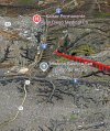
Looks like it was tracking the 28R localizer and descended into high terrain about a mile and a half short of the runway with a fairly fast descent rate, but not anything that looked out of control at first glance.

IMG_5595.jpeg

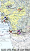
Here’s the weather synopsis at the time:

IMG_5594.jpeg

Active NOTAMs for the 28R ALS and PAPI being out of service. Edit: It looks those went active after the accident.

More info will come.
 
Last edited:
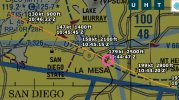
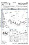
Reported ADS-B Altitude was 2500 at the FAF PENYY, which is correct per the ILS and RNAV approach plates. Note that altimeters at the time were basically reporting standard sea level pressure, give or take, so not a lot of ambiguity there. Groundspeed was 180 knots at the FAF, slowing to around 130 moments prior to the crash. Per above, surface winds were basically nil. Forecast winds aloft at that time at 010 were nil to maybe a few knots out of the south, at 030 were nil to maybe a few knots out of the north.

PENYY is circled below:

IMG_5597.jpeg

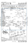
Here are the relevant plates. I’ll include both the ILS and RNAV:

IMG_5598.jpeg

IMG_5599.jpeg
 
Link to LiveATC audio of SOCAL (add an https and copy and paste): ://archive.liveatc.net/ksan/KSAN-SOCAL-App-Dep-West-May-22-2025-1030Z.mp3

The ASOS at MYF was down at the time and it sounds as bit like he was shopping for weather at other airports, even considering SDM as an alternate, which wasn’t much better (and has higher mins anyway). He did not sound confident they’d make it in to MYF. Ended up getting cleared for the RNAV 28R at NESTY.

They checked in on CTAF on a 3 mile final and clicked the mic 7x, ostensibly to turn the PCL on. That was the last transmission.

Note that when they departed Jabara (AAO) at 0730z, the forecast TAFs issued at 03z for Miramar (NKX) showed a TEMPO 6000 BR OVC005 during the arrival period. The 09z TAF for NKX updated this to 8000 BR OVC003

The 0520 TAF for SAN showed TEMPO 2SM BR OVC005 during the arrival period.

At 0630z, AWC showed the forecast clouds for 11z as broken to overcast with bases anywhere from 003 to 006 (MSL) in the area. MYF is up on a plateau at 427 MSL and the bases can be a bit deceiving as they can rise upslope from the coast.

There were active AIRMETs for IFR in that area, one issued at 0245z and renewed at 0845z: CIG BLW 010/VIS BLW 3SM BR/FG.

Operational considerations notwithstanding, SAN generally had the best weather in the San Diego proper at the time with 9SM OVC010. RNM was reporting 8SM CLR at the time and is not much further from MYF than SDM is.

None of this is unusual for San Diego weather at night with an offshore flow. The entire coast up to a few miles inland was socked in from LAX to the border.
 
We have had some dense fog in parts of San Diego over the last couple of days and have heard from people who evacuated that it was very foggy at the time.

And there are reports that there are some downed high tension powerlines in the area. A local radio station is in the area, KOGO, who I listed to in the morning. Said the lights flickered in their office at the time of the crash.
 
Last edited:
Does the ADS-B data show enough data to determine at what point they may have descended below the glideslope? What I was able to tell was 600 ft (177 ft above TDZE) at 1.9 miles. Above it’s mentioned that they were at 2500 at Penny. Obviously they descended below but I’m curious when the deviation began.
 
We have had some dense fog in parts of San Diego over the last couple of days and have heard from people who evacuated that it was very foggy at the time.

And there are reports that there are some downed high tension powerlines in the area. A local radio station is in the area, KOGO, who I listed to in the morning. Said the lights flickered in their office at the time of the crash.
Considering he nearly shaved the top off the small ridge about 1000’ to the east of the accident site and there are high tension powerlines running along it, oblique to the approach, I’m guessing he hit those prior to ending up in the neighborhood. There is an obstruction marked as 554 (MSL) on the approach charts about at that spot.

To give you an idea of how unusually low he was, at that location, he should have been at about 600’ above the airport or 1054 MSL. This would have been 500’ over the notional obstacle on the chart. The elevation of that small ridge at the edge of the plateau right where the powerlines and the final approach course meet is 415’ MSL, so add 140 or so for the powerline and 554 checks out.
 
Do we know how many in the cockpit. Isn’t the 550 authorized for single pilot IFR?
Yes, if the PIC has the single pilot authorization.

Insurance was getting pretty pricey for single pilot ops though and we've been seeing fewer single pilot operators as a result.
 
Someone on Beechtalk mentioned the alignment of the road where the accident occurred was similar to the runway.....I'm kind wondering if he got saw the lights and thought it was the runway and that may have been the reason for the descent below the GS?
 
Yes, if the PIC has the single pilot authorization.

Insurance was getting pretty pricey for single pilot ops though and we've been seeing fewer single pilot operators as a result.
What about configuration changes. Where would someone typically throw down the gear?
 
What about configuration changes. Where would someone typically throw down the gear?
Same as most airplanes - you put down the gear before intercepting GS. Sooner if you needed to slow down, but in a turbine you rarely if ever change configuration inside the FAF.

We're always fully configured in the 500/550 by the FAF.
 
Same as most airplanes - you put down the gear before intercepting GS. Sooner if you needed to slow down, but in a turbine you rarely if ever change configuration inside the FAF.

We're always fully configured in the 500/550 by the FAF.
@Flying Keys noted above that GS was 180 knots at the FAF. Seems a little fast to be fully configured, but I don’t remember the flap speeds on the 550.
 
Does the ADS-B data show enough data to determine at what point they may have descended below the glideslope? What I was able to tell was 600 ft (177 ft above TDZE) at 1.9 miles. Above it’s mentioned that they were at 2500 at Penny. Obviously they descended below but I’m curious when the deviation began.
The data are finite enough to show that, and while I can’t do a full vertical analysis at the moment, at an initial glance the vertical path looks unstable at several places from the FAF inbound. Ducking below the glidepath, nearly leveling off, and reacquiring a few times. The point it really diverged was about 3NM from the glideslope antenna (3.6DME), where it went from nearly level to a 1500-1700FPM descent pretty much all the way to the powerlines 1.2NM later, dropping ~725’ in the process, for a descent angle of about 5.8°.

Here’s a Q&D illustration - the blue arrow is PENYY and the yellow line is the approximate glidepath of the approach:

IMG_5602.jpeg

You can see the various step downs and level-offs during the final approach segment.
 
It should be noted we don’t know the RNAV capabilities aboard the aircraft. If this was an LNAV-only approach, then it puts the step down at PALOS into play, which is right about where the terminal dive commenced. It would also explain the level off just prior.
 
It should be noted we don’t know the RNAV capabilities aboard the aircraft. If this was an LNAV-only approach, then it puts the step down at PALOS into play, which is right about where the terminal dive commenced. It would also explain the level off just prior.
With reported weather below to at best minimums, why on earth would someone fly an LNAV only GPS approach with higher mins instead of the ILS 28R? There is no NOTAM showing the ILS out.

That profile you posted looks like a slight dip below GS and then correcting rather than stepping down.
 
Someone on Beechtalk mentioned the alignment of the road where the accident occurred was similar to the runway.....I'm kind wondering if he got saw the lights and thought it was the runway and that may have been the reason for the descent below the GS?
It was a fairly steady descent angle from PALOS to the accident site. Based on the derived altitudes and weather reports, it’s unlikely, but not impossible, he could clearly see those street lights from that location. Of course there could have been a clear spot that revealed them. I’ve also checked weather cams and the fog layer was thin but well inland to the La Mesa and El Cajon areas (the areas underneath the approach) at that time. I estimate the top of the layer to be between 800 and 1000’ MSL.

Lots of glow, but no lights apparent in that area.


That profile you posted looks like a slight dip below GS and then correcting rather than stepping down.
Right, unless you look at it as a dive and drive non-precision approach with no vertical guidance. Then it could be interpreted as an attempt to level off for PALOS at 1300 before continuing the descent. But yes, if it had vertical guidance, then your interpretation could be correct.
 
I'll hazard a guess they were picking up the plane after maintenance or training from Wichita, running late and flying fatigued on the backside of the clock. Long crew days lead to making dumb mistakes, like skipping or misreading checklists, flipping switches the wrong way or getting behind the airplane on an approach. I hate the backside of the clock.
 
The data are finite enough to show that, and while I can’t do a full vertical analysis at the moment, at an initial glance the vertical path looks unstable at several places from the FAF inbound. Ducking below the glidepath, nearly leveling off, and reacquiring a few times. The point it really diverged was about 3NM from the glideslope antenna (3.6DME), where it went from nearly level to a 1500-1700FPM descent pretty much all the way to the powerlines 1.2NM later, dropping ~725’ in the process, for a descent angle of about 5.8°.

Here’s a Q&D illustration - the blue arrow is PENYY and the yellow line is the approximate glidepath of the approach:

View attachment 141297

You can see the various step downs and level-offs during the final approach segment.
Thanks Flying Keys. What program are you using to look at the data overlaid with the glideslope? I remember previously being able to import data to Cloudahoy back when i tried it out for a trial period. Nearly impossible to tell much from things like FlightAware without a lot of math.
 
I'll hazard a guess they were picking up the plane after maintenance or training from Wichita, running late and flying fatigued on the backside of the clock. Long crew days lead to making dumb mistakes, like skipping or misreading checklists, flipping switches the wrong way or getting behind the airplane on an approach. I hate the backside of the clock.
Here’s a more complete timeline:

The aircraft departed from Teterboro at ~0315z (11:15pm EDT/8:15pm PDT) and landed at Jabara in Wichita at ~0650z (2:50am EDT/1:50am CDT/11:50pm PDT). That’s about 3.6 hours in the air.

After about a 45 minute stop, it then departed Jabara at ~0735z (3:35am EDT/2:35am CDT/12:35pm PDT) and crashed at ~1047z (6:47am EDT/3:47am PDT). Another 3.2 in the air for a total of 6.8 flight time and 7.5 total time since departure.

That’s a long night. I agree with the circadian rhythm and fatigue possibilities.
 
I'll hazard a guess they were picking up the plane after maintenance or training from Wichita, running late and flying fatigued on the backside of the clock. Long crew days lead to making dumb mistakes, like skipping or misreading checklists, flipping switches the wrong way or getting behind the airplane on an approach. I hate the backside of the clock.
It was a quick turn in Wichita (Jabara). So an all night flight from Teterboro. Speculation on fatigue is understandable but who knows at this point. Insert standard disclaimer about being too early to know anything here.

Pilot mentioned they thought their chances in reported local conditions appeared marginal.

I’d hate to infer too much from the track about decision making. Mostly I look at these bits of data as things to store away to remind myself what signs I might see on a similar approach under similar conditions that indicate I’m tiptoeing over a line and need to recalibrate (e.g. go missed) before I’m past the point of no return.
 
Adding one detail to the audio summary in post #6, SoCal queried the pilot which approach he wanted. The pilot requested RNAV 28.

Note the RNAV 28 is authorized only for Cat A/B.
 
Thanks Flying Keys. What program are you using to look at the data overlaid with the glideslope? I remember previously being able to import data to Cloudahoy back when i tried it out for a trial period. Nearly impossible to tell much from things like FlightAware without a lot of math.

You can import the KML file from ADS-B Exchange to www.FlySto.net (which is free and far superior to Cloudeahoy) and then watch the flight in 3D.
 
TRANSCRIPT:

666DS: Socal Citation triple-six delta sierra will be descending through 17 thousand for 12 thousand
SOCAL: Citation triple six delta sierra, social approach. The Montgomery ASOS is out of service. Which approach would you like.
666DS: 6DS. Yeah, we noticed that. We'll take the RNAV 28 please.
SOCAL: You're cleared direct NESTI, Descent pilots discretion maintain 9 thousand
666DS: OK direct NESTI descend 9 thousand


666DS: and 6DS I just wanted to know if you had any idea on the weather. I got the Gillespie weather but I am sure you know it can be dramatically different between Gillespie and Montgomery.
SOCAL: 6DS Let me see what I can find out for you.
666ds: OK thanks. According to Gillespie it's pretty much down to minimums. I want to see what I'm in for here.

SOCAL: 6DS I've got the Miramar Automated Weather for 0955Z, wind calm, visibility 1/2, indefinite ceiling 200
666DS: 6DS Allright that doesn't sound great, but we'll give it a go.
SOCAL: 6DS Roger. Descend and maintain 5 thousand 5 hundred.
666DS: Descending for 5 thousand 5 hundred 6DS

666DS 6DS Justin case we have to go missed what does Brown look like? Is it looking pretty similar.
SOCAL: Let me check for you

SOCAL: 6DS. A little bit better but not much. Showing 1031Z weather wind calm visibility 2 1/2 mist ceiling 300 broken rather overcast.
666DS: OK a little better, but higher minimums. So probably not a good idea either. I'll come back to you in a minute with an alternate.

-- 54R reports something for Delta Romeo here but I can't make it out --

SOCAL: 6DS SOCAL you make the descent OK from there or do you want me to turn you out to the south a little bit. (this gets repeated after no answer)
6DS: No, I think we'll be alright.
SOCAL: Roger 5 miles from Nesti, cross at or above 3800 cleared rnav 28R approach
6DS: At or above 3800 cleared rnav 28R approach Montgomery

SOCAL: 6DS report IFR cancellation after landing via phone. Do you have the number
6DS: 6DS yeah I've got the number.
SOCAL Frequency change approved.
6DS: We'll hopefully not see ya, but we might have to.
SOCAL: OK
 
Hindsight is always 20-20, but the communications from the pilot got less and less professional as time went by.
 
@Flying Keys noted above that GS was 180 knots at the FAF. Seems a little fast to be fully configured, but I don’t remember the flap speeds on the 550.

That feels fast (assuming the IAS is similar) to me as well, but I'm not sure everyone plans to be fully configured by the FAF. In my 135 Citation days we just needed to be there by 1000' - same as what we do today at my 121 shop.
 
Interesting that he never asked for SAN weather nor did the controller offer it. SAN was LIFR (using ILS 9) but as far as minimums go, Lindbergh had the best weather in the area.
 
My son knew the pilot. He was a businessman owner operator aged in his 50s. His business is a popular booking agent type firm that set's up concert tours and arranges venues for popular music groups.

My son has no idea about the pilot's experience, or frequency of flying.

On the subject of nighttime RNAV approaches through low ceilings into low vis at smallish airports, I've only done a few, and don't like them one bit. There's something comforting flying an ILS at night and seeing the clouds glowing up ahead before the high-intensity lead-in lights becomes visible. This eliminates any desire (at least for me) while flying an RNAV approach to search out ahead for the runway lights... which can appear the same as the parking lot lighting at Walmart.
 
Last edited:
Based on pics posted on the following link, they probably were planning LPV mins with the Garmin 750:

Good pull. So then it’s back to the question if they were on the LPV, why was the vertical profile so unstable? The lateral track is so straight that I assume they were using some sort of automation, at least laterally.
 
The 550 I flew (previously) would AP couple the LPV GS on its Garmin 750. But they say, if you have seen one Citation…you have seen one Citation. All are different, quirky, cobbled together.
 
The 550 I flew (previously) would AP couple the LPV GS on its Garmin 750. But they say, if you have seen one Citation…you have seen one Citation. All are different, quirky, cobbled together.

Especially the older ones that have had various avionics upgrades during their life. Some, like this one, don't even have the factory model engines.

It does seem like there have been more than average number of turbine aircraft accidents lately, several being owner-operated.
 
Reporting from Fox News now reports the aircraft hit a pole, shearing the wing. Fell into a large military housing area.
 
Here's a good clear-night view of an approach into 28R:

The big dark area you see in the foreground at 6:50 (where the linked video starts) is the bluff with the powerlines at the top. The bright lights above that are for a ballfield. I doubt they'd be on at almost 4 AM. But those could be the "poles" @KE5BM is talking about?

Based on that, I don't think the street lights could easily masquerade as the runway lights as they seem to be very obscured, probably by trees in that neighborhood.
 
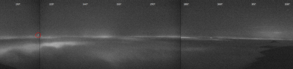
Wow, I am almost positive this is the accident aircraft just before it goes into the fog (timestamp 1045:46z. taken from Cowles Mountain to the east of the accident site, north of the FAC):

1747951164238.png

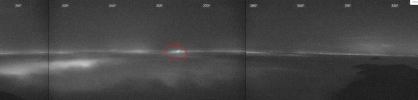
And the next framegrab from the same camera at 1049:47z shows a flareup triangulated right at the accident site, which persists for the next 20 or so minutes:

1747951343801.png
 
My son knew the pilot. He was a businessman owner operator aged in his 50s. His business is a popular booking agent type firm that set's up concert tours and arranges venues for popular music groups.

My son has no idea about the pilot's experience, or frequency of flying.

On the subject of nighttime RNAV approaches through low ceilings into low vis at smallish airports, I've only done a few, and don't like them one bit. There's something comforting flying an ILS at night and seeing the clouds glowing up ahead before the high-intensity lead-in lights becomes visible. This eliminates any desire (at least for me) while flying an RNAV approach to search out ahead for the runway lights... which can appear the same as the parking lot lighting at Walmart.

The guy on the radio sounded younger to me than someone in his 50s. So I'm assuming the owner was flying the aircraft and his co-pilot was handling the communications.

Very sad, complacency kills.
 
Back
Top