Low Level Flyer
Pre-Flight
- Joined
- Jan 19, 2020
- Messages
- 84
- Display Name
Display name:
Low Level Flyer
By the looks of your map, I’m guessing you went thru flight school between 1992 & 2000.
By the looks of your map, I’m guessing you went thru flight school between 1992 & 2000.
Yep. April 2000 - July 2001. Back again as an IP 2005-2009.By the looks of your map, I’m guessing you went thru flight school between 1992 & 2000.
Children of the magenta line also have no clue how often they’re lost. I’d rather be lost and know it than lost and not know it.When I tell my kid I flew in Germany with 1:50,000 terrain maps for the whole country, made into map books per region…also posted all the wire hazards and towers by hand she just rolls her eyes and laughs…Children of the magenta line have no clue how often we were lost…and won’t ever admit that part…but it is a skill (using a map) that is lost on new pilots.

Depending on where, how, and what I was flying, I might and i learned and flew with paper for 20 years. Thats because I have no idea where to get a paper chart on short notice. I’d have to find a flight school and hope they had some to spare.I would say 90% of pilots in training today would cancel their flight if their iPad was dead and all they had was a paper map to reference. The need the moving map because they have only known it that way.
Nowadays you can just download the chart from the FAA website and print out just the portion(s) you need.Depending on where, how, and what I was flying, I might and i learned and flew with paper for 20 years. Thats because I have no idea where to get a paper chart on short notice. I’d have to find a flight school and hope they had some to spare.
Yeah, but why would I? And using whose printer? I’m assuming I’m at the airport when the problem arises. If I’m at home the day before, I have far better options than a bunch of paper.Nowadays you can just download the chart from the FAA website and print out just the portion(s) you need.
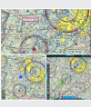
What makes you think that? These are captures from Foreflight, FlyQ, and FltPlan Go! I could add Garmin Pilot, Stratus Insight, IFly, DroidEFB, and others, Foreflight was using them back when I first subscribed (13 years ago today!)But maybe that's why I prefer Avare, as its displayed map is an actual sectional chart rather than the simplified map used by Foreflight or other devices
I stand corrected; I didn't know that. Usually when people post screen captures from FF or other apps they show the simplified view (which Avare doesn't have), so I [apparently incorrectly] assumed at was all there was.What makes you think that? These are captures from Foreflight, FlyQ, and FltPlan Go! I could add Garmin Pilot, Stratus Insight, IFly, DroidEFB, and others, Foreflight was using them back when I first subscribed (13 years ago today!)
I’m not aware of an EFB on iOS, Android, or Windows used in the US in which the FAA’S Sectionals is not an option. It’s even available in some panel MFDs.
View attachment 124722
That's because, to many pilots who use them, what you refer to the "simplified view" is superior to the Sectional. It's really not "simple" at all. It's declutterable, which just means the amount of detail is customizable and increases and decreases with the zoom level. Airspaces are highlighted with touchable pop-up information. Being software generated, rather than mostly static graphic, if you prefer track up, the lettering is always upright no matter which way your direction of flight. It's my preferred view IFR. The Sectional is still my preferred view VFR.I stand corrected; I didn't know that. Usually when people post screen captures from FF or other apps they show the simplified view (which Avare doesn't have), so I [apparently incorrectly] assumed at was all there was.
You brought back a memory.This recent discussion amuses me. So you're at the airport and your iPad dies. Oh, go get a paper chart. Really? Where? So, yes, of course some pilots might cancel their flight if their iPad died - because if it did, they might not have, or be able to get, paper charts. But that's pretty much the same result as if you forgot, or lost, your paper chart.
I usually say give me a couple of each. The looks I get are priceless.Personally, I find “Paper vs Plastic: My Choice is Right: Yours is Wrong “ pretty silly, so I have fun responding to them.
it’s funny. That often seems to be the way it shakes out, but I don’t think It really have that much to do with age.This sounds a lot like the discussion in engineering offices about us old guys who started out on the drafting board vs. the kids who used CAD from day one.
Now, where's my eraser shield?
If you had no chart it's ok to cancel. My scenario has the genZ pilot with any combination of TACs and sectionals and they still wouldn't fly.Depending on where, how, and what I was flying, I might and i learned and flew with paper for 20 years. Thats because I have no idea where to get a paper chart on short notice. I’d have to find a flight school and hope they had some to spare.
Why would your scenario's hypothetical GenZ pilot who has always used an EFB even have any combination of paper TACs and sectionals? Kind of strikes me as continuing the rant against the next generation originally attributed to Socrates.If you had no chart it's ok to cancel. My scenario has the genZ pilot with any combination of TACs and sectionals and they still wouldn't fly.
Your scenario is probably equally true. The thread is about flying without paper though. I feel like the old guy would just go flying without the charts. As a matter of fact, I know old guys who can still make a plane go places without moving maps and ipads.Why would your scenario's hypothetical GenZ pilot who has always used an EFB even have any combination of paper TACs and sectionals? Kind of strikes me as continuing the rant against the next generation originally attributed to Socrates.
How about this scenario for contrast? Quoting from yours (changes in italics)
I would say 90% of old fart pilots with their heads firmly stuck in the past would cancel their flight if their paper charts fell into a puddle and all they had was an iPad and modern avionics for reference. They need the paper map because they have only known it that way.
No paper charts or EFB? I assume that means no Chart Supplement either. For me, as I indicated earlier, depends on what, where, and how (VFR or IFR) I was flying. Can I meet my FAR 91.103 responsibilities without them?Your scenario is probably equally true. The thread is about flying without paper though. I feel like the old guy would just go flying without the charts.
The most valuable thing helo pilots in Vietnam had were 1:100,000 maps. They were extremely hard to get, and when an aircraft commander headed back to the states, he customarily bequeathed his area of operation map set (carefully marked with firebase locations and assembled with clear acetate overlay sheets) to a new a/c in his platoon. I brought a captured weapon home, but left my most valuable possession with someone who needed it much more than I did.I Know the services have gone EFBs but I don’t think they will ever get rid of paper. Especially for VFR nav. Gotta have back ups to fall on. Nav with a 1:50,000 map sux.
Yeah we got used, hand me down 1:100,000s from the 101st prior to going from Kuwait into Iraq. They were almost useless in the south because it’s like sand, and then more sand. When my GPS broke they came in handy though. Once we set up shop, we printed strip maps on Falcon View and ditched our 101st map books.The most valuable thing helo pilots in Vietnam had were 1:100,000 maps. They were extremely hard to get, and when an aircraft commander headed back to the states, he customarily bequeathed his area of operation map set (carefully marked with firebase locations and assembled with clear acetate overlay sheets) to a new a/c in his platoon. I brought a captured weapon home, but left my most valuable possession with someone who needed it much more than I did.
Try flying in the Gulf of Mexico in 1974 with a paper map (solid blue) marked only with little symbols for dispersed drilling platforms. Out there in the wide open with nothing but a few dots on the horizon. In a Bell 47G4 with a mag compass that was about 45 deg. out. You had to get a gestalt feel for your fuel range and the overall scheme of things. Then you could mentally connect those dots. At least when you labored at 70 kt toward one eventually you would see a number marking on the platform. Better than the sand I would expect, but probably some similarities. Tales from antiquity, lol.Yeah we got used, hand me down 1:100,000s from the 101st prior to going from Kuwait into Iraq. They were almost useless in the south because it’s like sand, and then more sand. When my GPS broke they came in handy though. Once we set up shop, we printed strip maps on Falcon View and ditched our 101st map books.