All traffic in the area, please advise


I've been flying for over 20 years and I still don't really know what multicom is/was supposed to be. Not a term that's been in use in a LONG time.
I see someone posted the AIM, etc. Here's what I learned many, many years ago from my primary CFI. Those small airports that might be attached to the Forest Service, but are definitely very low or very seasonal airports will get Multicom.

So there are a couple of airports at Priest Lk, ID where one is ID Dept of Lands and the other is US Forest Svc that both have 122.9. Fair amount of traffic, but that equals MAYBE two in the pattern at most unless there's a fly-in. :) It the nearby towns that have hangars, some training, fuel, etc., but not a whole lot more traffic in the summer, but they always get a Unicom. And sure, there's some document somewhere that probably lays all this out as to who gets what, but flying all over the country that concept of really small or seasonal will be on Multicom has held up.
 
From now on, when I get told “taxi to parking, remain this frequency”, I am going to respond “taxi to parking, same Bat channel”.
NOOOOO!!!!.... You're missing the only opportunity you can actually say "With You" to a Controller and not have them get ****ed at you!! :)
 
One of these days I’ll work on my east coast “seee yah” and say it when changing frequencies in china lol
 
I mean, it would probably make more sense to bow to the inevitable and swap those frequencies. That way all the cool kids can keep chatting it up on "fingers" while the test pilots can use the frequency that apparently no one else knows anything about.
I'm not sure you're serious but yours was a handy quote. I find it remarkable that pilots will burst a blood vessel over two extra words on 'their' freq ("with you") but think nothing of co-opting a freq that they are prohibited from using and that someone else was assigned for a legitimate purpose, then rationalize it with "just switch frequencies" without realizing those freqs are assigned, not personally selected for our convenience.

Nauga,
and his old soapbox
 
I find it remarkable that pilots will burst a blood vessel over two extra words on 'their' freq ("with you")

but think nothing of co-opting a freq that they are prohibited from using and that someone else was assigned for a legitimate purpose, then rationalize it with "just switch frequencies" without realizing those freqs are assigned, not personally selected for our convenience.
Do you think the same pilots make up these two groups?
 
I'm not sure you're serious but yours was a handy quote. I find it remarkable that pilots will burst a blood vessel over two extra words on 'their' freq ("with you") but think nothing of co-opting a freq that they are prohibited from using and that someone else was assigned for a legitimate purpose, then rationalize it with "just switch frequencies" without realizing those freqs are assigned, not personally selected for our convenience.
If people are using 123.45 and telling legitimate test-pilot users to "just switch frequencies", then they are absolutely in the wrong and should be censured.

My point is more from a human factors perspective, primarily the principle that as much as possible it's better to adapt the system to the user rather than the user to the system, at least within reason. In this instance, I make the assumption that the current frequencies are assigned without a particular reason for that frequency (e.g., interference, proximity to other frequencies). If that's the case, then the current frequency assignments are there as a matter of practice, rather than necessity. Since the volume of people wanting to talk on "fingers" as a GA air-to-air frequency likely grossly outweighs the number of test-pilot users, and because 123.45 is a very easy frequency to remember and teach as a non-emergency frequency that could be used to reach out to other pilots, it follows that there may be some benefit to reassigning that frequency as the GA air-to-air. Test-pilots, being consummate professionals, are likely indifferent to whatever frequency they need to use during their activities, as long as it's accurately briefed prior to the sortie.

Distilled, my argument is that people are going to use 123.45 anyway and there's probably nothing the FAA can do about that, so just bow to the inevitable, make the formal change, and the problem of "wrong frequency" and interference in test operations goes away.
 
From now on, when I get told “taxi to parking, remain this frequency”, I am going to respond “taxi to parking, same Bat channel”. :)

Sorry, kids, I know you won’t get it.
adam.png
Basic cable. (And when nosy people or websites ask for an address I give "211 Pine Street, Mayfield".)
 
Distilled, my argument is that people are going to use 123.45 anyway and there's probably nothing the FAA can do about that, so just bow to the inevitable, make the formal change, and the problem of "wrong frequency" and interference in test operations goes away.
I eagerly await a similar proposal for 121.5

Nauga,
meow
 
I eagerly await a similar proposal for 121.5
Come now, that's hardly a good faith response and not a similar situation. In one, there are two frequencies discretionally assigned, and a reasonable argument can be made that common usage argues for a switch in assignments, without loss of utility and a potential for gain (students could perhaps be taught to make a call on "fingers" for non-emergency questions). For the fools on 121.5, it's human nature to be a moron when anonymous, and short of some system that identifies the transmitting aircraft's callsign when transmitting on that frequency (with attendant consequences for inappropriate use) I'm not sure there's a good solution to that.
 
In one, there are two frequencies discretionally assigned, and a reasonable argument can be made that common usage argues for a switch in assignments, without loss of utility and a potential for gain (students could perhaps be taught to make a call on "fingers" for non-emergency questions).
Students should have been taught the correct frequencies for 'everyday' air to air usage and proper use of Unicom and Multicom freqs. I do realize that it's as unlikely that pilots will suddenly accept that 123.45 and 123.4 are not valid A/A freqs as it is that the FCC (who manages the spectrum, not the FAA) will reassign those freqs to general use and provide two new freqs for the flight test station pool. That doesn't mean I'm going to stop complaining about people that can't stay off of either one.

Do you think the same pilots make up these two groups?
I know some that are in both groups. I suspect there are more.

Nauga,
the realist.
 
I'm not sure you're serious but yours was a handy quote. I find it remarkable that pilots will burst a blood vessel over two extra words on 'their' freq ("with you") but think nothing of co-opting a freq that they are prohibited from using and that someone else was assigned for a legitimate purpose, then rationalize it with "just switch frequencies" without realizing those freqs are assigned, not personally selected for our convenience.
If that was for my "With You" then, no, I'll bust a blood vessel over using "fingers" or an other dumb ass thing. :)

I don't fly professionally, but I try to fly professionally. Sure we all (hopefully) are having a lot of fun when we fly. But it's not a college party with all the pranks that usually no one gets hurt.

(And my soap box is pretty worn out, not even sure if you can stand on it any more. :cool:)
 
If that was for my "With You" then, no, I'll bust a blood vessel over using "fingers" or an other dumb ass thing. :)
Aw....no, it was just the first example of comm nitpicking that came to mind as I was typing the post. No offense intended.

Nauga,
with or without you
 
If the pattern isn't too busy and someone announces on the radio "At DUMBR for the RNAV GPS 36" I reply with something like "no idea where that is, what's your bearing and distance from the airport?"

I recently had a jet announce "Inbound from Zavum" while I was holding short ready for takeoff. Even though this is my home airport and I know all the fixes, I don't have their distances memorized for every single approach. I asked "say current distance from runway" and all he could say was "we are now 2 miles east of SOVVO". I asked him a couple more times but never got a clear answer.
 
Proper children of the magenta line.
I have to confess struggling with the same thing - when you're in the middle of an approach, the distance to the end of the runway requires adding several numbers together, whilst yet managing all the other aspects of an instrument approach (because the magic magenta-line box only tells you the distance to the next waypoint). Takes a little more brain capacity than may be available (from some of us). One of the issues with those 'practice approaches' on VFR days.
Best I can usually do is a rough estimate (which is usually 'good enough').
Does your EFB allow you to configure your data display to also provide time and distance to destination? That's handy info to avoid running out of gas.
 
I have to confess struggling with the same thing - when you're in the middle of an approach, the distance to the end of the runway ….

Depending on the navigator you’re using, you can usually configure a page to show the exact distance from present position to the destination airport, which is close enough.

You can also offload that duty to the safety pilot.
 
I have to confess struggling with the same thing - when you're in the middle of an approach, the distance to the end of the runway requires adding several numbers together, whilst yet managing all the other aspects of an instrument approach (because the magic magenta-line box only tells you the distance to the next waypoint).
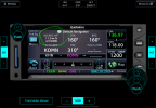
Which magic magenta line box do you have? In the GTN series, that's a user selectable field for several of the screens. I have it on my NAV screen and MAP screen. Use it for distance in practice approaches, telling tower distance and bearing and for when tower asks for a call at 4 miles etc.
 
I have to confess struggling with the same thing - when you're in the middle of an approach, the distance to the end of the runway requires adding several numbers together,
Should I assume you only have one device? There really isn't another display that is set up that always just shows Distance to Destination?

But if there isn't, no biggie, a WAG is all anyone needs, so who cares if one leg is 3.7 and the next is 4.5 and you say 8 or 9. :) But these situations are usually VMC, so a quick hit of Nearest Apt on your EFB or even the GPS (since it is VMC) shouldn't be a big deal.

Added: Saw after I posted that it looks like you got multiple replies. Didn't mean to gang up on you. :cool:
 
If only there was some way to tell distance to something……….

80fb76639729f6ae2b4cae11890f2ae0.jpg


And really? You can’t quickly add a coupl’a numbers together ? Sheeeit I’m a dumb dumb and even I can add a couple of numbers that usually comes close to 10 and I don’t maths at all.
 
If only there was some way to tell distance to something……….

80fb76639729f6ae2b4cae11890f2ae0.jpg


And really? You can’t quickly add a coupl’a numbers together ? Sheeeit I’m a dumb dumb and even I can add a couple of numbers that usually comes close to 10 and I don’t maths at all.
If I'm looking at an approach plate on the iPad, that VFR chart isn't displayed. And, with an approach active on the panel GPS -
1741970214967.png
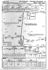
For the extra $120 a year, FF shows me where I am on the plate. Say you're between between Conan and Fangu: quick - how far to the runway (whilst listening for a possible ATC call, hand-flying a heading and altitude in turbulence, pre-landing checklist, etc.) ?
 
......For the extra $120 a year, FF shows me where I am on the plate. Say you're between between Conan and Fangu: quick - how far to the runway (whilst listening for a possible ATC call, hand-flying a heading and altitude in turbulence, pre-landing checklist, etc.) ?
I'm briefed LONG before that. I know that at conan I'm ROUGHLY 12ish miles from the rwy.

hol' up.....I don't use jepp....jepp tells u EXACTLY how far u r from the rwy at conan...12.5. you can't estimate APPROXIMATELY how far you are if you're in between???
 
We have a busy nontowered airport nearby that uses the same frequency as our field. It's pretty common to hear pilots arriving there to call & verify that a car is ready for whomever is on board. Sometimes a name is given and I've heard a few impressive ones over the years.

Impressive like they're well-known, or impressive like "Pull the Escalade around for Phil Mianus and Haywood Jablomi?"
 
Impressive like they're well-known, or impressive like "Pull the Escalade around for Phil Mianus and Haywood Jablomi?"

Well known as in presidential candidates or CEOs of a large corporations ...
 
I'm briefed LONG before that. I know that at conan I'm ROUGHLY 12ish miles from the rwy.

hol' up.....I don't use jepp....jepp tells u EXACTLY how far u r from the rwy at conan...12.5. you can't estimate APPROXIMATELY how far you are if you're in between???
Grabbed the wrong example - I don't have the Jepp charts either. Didn't realize they provided that. The gov't plates don't include that distance summary.
 
If I'm looking at an approach plate on the iPad, that VFR chart isn't displayed. And, with an approach active on the panel GPS -
View attachment 139029
For the extra $120 a year, FF shows me where I am on the plate. Say you're between between Conan and Fangu: quick - how far to the runway (whilst listening for a possible ATC call, hand-flying a heading and altitude in turbulence, pre-landing checklist, etc.) ?

Sure you can overlay plates on the VFR sectionals, that’s one of my default ways to run it


IMG-6507.jpg


Distance wise you should have that on your FMS page

You can also get the bottom readings on foreflight to show distant to nearest field with 9/10 times will be the airport you’re shooting the approach into


Also having the range rings on is smart

Knowing how wide common airspace is will give you a quick and dirty scale too
 
Last edited:
Grabbed the wrong example - I don't have the Jepp charts either. Didn't realize they provided that. The gov't plates don't include that distance summary.
Yea, but my point before, IF you don't already have Dist to Dest showing someplace, is to just not over think it. Just round out the numbers, it isn't going to make that much difference if someone on the ground is wondering if they can take off before you get there.

I just pulled up a random Gov. plate and the segments are 6, 2.9, 0.8 & 1.1. Now I'm going to know my distance to the next Fix, so let's say I've got 3.7 left out of that first 6nm leg. So 4+3+1+1 = 9 Does it really matter that I didn't spend the time to figure out the exact math and say 8.5? If I'm on the ground and here a single engine is more than 3 out, I'm departing without a second thought. If I'm on the ground and hear a jet is 5 out, I might think about it, but 7, 8+, I'm still going. It's is more the range not the exact distance.

And we're talking Approach plates, but a VFR/VMC situation here. If it were IMC, ATC would be the one letting the next plane depart, so they wouldn't be asking. (Though it could be an issue if it were MVFR I guess.)
 
If I'm looking at an approach plate on the iPad, that VFR chart isn't displayed. And, with an approach active on the panel GPS -
View attachment 139029
For the extra $120 a year, FF shows me where I am on the plate. Say you're between between Conan and Fangu: quick - how far to the runway (whilst listening for a possible ATC call, hand-flying a heading and altitude in turbulence, pre-landing checklist, etc.) ?
It says "5.5" right under FANGU on the profile view, so I would take my distance to FANGU + 5.5. Or 5 or 6, it doesn't have to be exact, if you're in a jet you're covering that half mile in 10-15 seconds anyway.
 
This is the NAV screen on a GTN (using the ipad simulator). Circled is a distance/bearing to airport user field. The active waypoint happens to be the same, but if you were on an approach, the readout would be to the airport. Menu button just to the left allows it to be selected. Have on this page and the map page. This page is where I am for 90% of the time flying IFR. I suspect many of the other GPS's have similar capability.
Screenshot 2025-03-14 at 4.34.11 PM.png
 
Back
Top