
luvflyin
Touchdown! Greaser!
- Joined
- May 8, 2015
- Messages
- 17,444
- Location
- Santa Barbara, CA
- Display Name
- Luvflyin
- Home Airfield
- KVUO
There is a way to do procedure entry on this Approach without DME. That would be via the Feeder from PIA to TUNGG.
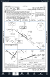


Yeah, ya need it for NINIC, but that’s not the only available entry. TUNGG is not an Intersection, the angle is to narrow, I don’t recall the exact requirement. The Feeder is direct to the Compass Locator. I was looking at PIA because it was mentioned in I think a different thread than that one. Anytime I look at an airport for anything I always check out the Approaches. It’s kinda like a hobby.On a quick look (so I may well miss something) I don't see a way to identify NINIC without DME. And while I guess in theory, find TUNGG by NDB or by the intersection of the PIA R112° and the localizer, I wonder what if there are TERPS requirements are for do that for this purpose. Or may it's just that it gets the note if any of the IAFs or transitions require it, so the fact that NINIC requires DME covers everyhting.
Harkening for a moment to the closed (I really can't figure out why) thread about what name to use for an airport for communication purposes, do you use "Peoria" for communications (as in the Tower box) or "General Downing"?
I think you are correct about the angle in this case.Yeah, ya need it for NINIC, but that’s not the only available entry. TUNGG is not an Intersection, the angle is to narrow, I don’t recall the exact requirement. The Feeder is direct to the Compass Locator. I was looking at PIA because it was mentioned in I think a different thread than that one. Anytime I look at an airport for anything I always check out the Approaches. It’s kinda like a hobby.
Sure. It's just a point in space in the database. GPS Substitution 101 as discussed in AIM 1-2-3. Load the approach in your IFR GPS, and select it. Since it's not a LOC course or on the FAS , there's not even a "raw data requirement." Hit the D→ button and there you go. (Although an approach-certified GPS is not required for this one).Would finding NINIC via GPS be permissible?

GPS can always sub for DME.Would finding NINIC via GPS be permissible?

But once we get past, "I can just do it GPS" or ground-based approaches which require GPS, I find it more useful to discuss ground-based approaches by forgetting about GPS. Not so much about ILS, which many pilots will still use or opt for, but the only time most pilots are likely to fly a LOC, VOR, or other nonprecision ground NAVAID approach is in the case of GPS failure. FWIW, I even bring that into the training environment. While it is legally proper and for many a checkride task to fly an approach like this with GPS in lieu of DME, I would only use it in an airplane with a DME receiver if there were no other option.
I've done a few LOC, VOR, and even a BC approach 121. We didn't have WAAS so sometimes those other approaches have minimums lower than LNAV minimums. That said, RNAV approaches were still second most common after ILS.Sure. It's just a point in space in the database. GPS Substitution 101 as discussed in AIM 1-2-3. Load the approach in your IFR GPS, and select it. Since it's not a LOC course or on the FAS, there's not even a "raw data requirement." Hit the D→ button and there you go. (Although an approach-certified GPS is not required for this one).
But once we get past, "I can just do it GPS" or ground-based approaches which require GPS, I find it more useful to discuss ground-based approaches by forgetting about GPS. Not so much about ILS, which many pilots will still use or opt for, but the only time most pilots are likely to fly a LOC, VOR, or other nonprecision ground NAVAID approach is in the case of GPS failure. FWIW, I even bring that into the training environment. While it is legally proper and for many a checkride task to fly an approach like this with GPS in lieu of DME, I would only use it in an airplane with a DME receiver if there were no other option.
Those situations definitely exist. My flying club has two G1000 airplanes. One does not have WAAS, so the issue can come up. But even then, the approach sequence is loaded and the extra step is going to green needles or a bearing pointer for the FAS, tasks that you need to do even if the approach did not require DME. I think the more significant "gotcha" for the GPS-dependent pilot is realizing that they still have to turn a HSI course pointer for a VOR (and sometimes for a LOC).I've done a few LOC, VOR, and even a BC approach 121. We didn't have WAAS so sometimes those other approaches have minimums lower than LNAV minimums. That said, RNAV approaches were still second most common after ILS.
YesWould finding NINIC via GPS be permissible?
Ok, take the PIA TUNGG Feeder out of the equation. You don’t need DME to locate TUNGG. Just ADF.I think you are correct about the angle in this case.
In terms of PIA, I might be wrong but when I think of "procedure entry," I think in terms of getting to an IAF, not a non-IAF transition to an IAF.
Yeah, I mentioned than in my first comment as one of the things I wasn't sure about from a design standpoint. 10.2 NM doesn't seem very long, but my guess is that it's not within the acceptable usable range for a LOM.Ok, take the PIA TUNGG Feeder out of the equation. You don’t need DME to locate TUNGG. Just ADF.
Yeah, range could be a thingYeah, I mentioned than in my first comment as one of the things I wasn't sure about from a design standpoint. 10.2 NM doesn't seem very long, but my guess is that it's not within the acceptable usable range for a LOM.
The LOM is used to identify theYeah, I mentioned than in my first comment as one of the things I wasn't sure about from a design standpoint. 10.2 NM doesn't seem very long, but my guess is that it's not within the acceptable usable range for a LOM.
Assuming you don’t have an outage.GPS can always sub for DME.
I see you just lined through intersection and called it a fix. It’s actually not a fix either. It is a Navaid. Yeah, I’d use the PIA 112 radial for starters. Once I had the holding heading established on that, then I’d change to using the ADF to homing in on the Locator.The LOM is used to identify theintersectionfix. You can use the VOR to get there.

Huh? The FAA calls PI the alternate missed approach fix on that ILS 31 IAP.I see you just lined through intersection and called it a fix. It’s actually not a fix either. It is a Navaid. Yeah, I’d use the PIA 112 radial for starters. Once I had the holding heading established on that, then I’d change to using the ADF to homing in on the Locator.
You’re right, by definition it is a fix.Huh? The FAA calls PI the alternate missed approach fix on that ILS 31 IAP.
All intersections are fixes, but all fixes aren’t intersections.

Peoria tower. Right there in the communication box. Same applies for ground and clearance delivery, though they only list the callsign once, with the tower frequency.Harkening for a moment to the closed (I really can't figure out why) thread about what name to use for an airport for communication purposes, do you use "Peoria" for communications (as in the Tower box) or "General Downing"?
The question was rhetorical.Peoria tower. Right there in the communication box. Same applies for ground and clearance delivery, though they only list the callsign once, with the tower frequency.
Is there still an exception for DME providing lateral guidance on final (like VOR 15 at MTN) or is that no longer an issue?GPS can always sub for DME.
I sent an inquiry in. "The equipment required box says DME required for procedure entry. While it would be needed for entry at the IAF NINIC, it would not be for entry at the IAF TUNGG." We'll see what they have to say.The IFP indicates the note was changed from "DME required" to "DME required for procedure entry" but no older documents are available to figure out what they were thinking when they put that note on in the first place. One can contact the FAA with potential errors; there are links on the IFP page to do so. I contacted them a number of years ago about a mistaken lightning bolt (glideslope intercept) symbol on a localizer-only approach and got a response within 24 hours.
You got me. From what I can tell GPS substitution isn't permitted in that case.Is there still an exception for DME providing lateral guidance on final (like VOR 15 at MTN) or is that no longer an issue?
Your Aeronautical Inquiry has been closed. If you have followup questions or comments, please use the online inquiry form instead of sending via email.I sent an inquiry in. "The equipment required box says DME required for procedure entry. While it would be needed for entry at the IAF NINIC, it would not be for entry at the IAF TUNGG." We'll see what they have to say.
I suppose Litte Rock is Little Rock, but if you are from KY it’s called LOO-uh-vul.What do you call Little Rock? Louisville?…..
Are you asking for a non DME or GPS aircraft? If you're in a plane with an IFR certified GPS, this is a non quesiton. If you're in a plane with no GPS and no DME, you can't fly the approach.There is a way to do procedure entry on this Approach without DME. That would be via the Feeder from PIA to TUNGG.
Like?There are some approaches where even if you have a GPS, you sitll must have a DME because there is no Waypoint for the GPS to fly to.
Approaches that have no DME Fixes that require DME??? Example?Are you asking for a non DME or GPS aircraft? If you're in a plane with an IFR certified GPS, this is a non quesiton. If you're in a plane with no GPS and no DME, you can't fly the approach.
NINIC, MKNTY, TUNGG and PIA are all identifiable with GPS, so no DME reciever is required in your plane if you have an IFR GPS. There are some approaches where even if you have a GPS, you sitll must have a DME because there is no Waypoint for the GPS to fly to. But those are becoming rarer and rarer these days.
Like?
With a quick search I found the KRBW ILS Z or LOC Z RWY 23 still shows "GPS and DME required." So in this case it is not a missing Wpt, but still DME required. It is possible that all the ones that just didn't have a fix back inthe day have been revised, but it wouldn't shock me if someone comes up with one local to them.Approaches that have no DME Fixes that require DME??? Example?
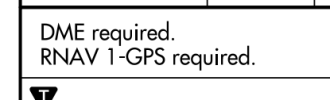
When I see something like this, my first thought is "charting error" because it makes no sense. If you send an inquiry using the gateway, I would not be a bit surprised if they say it's an error, all you need is GPS, and it will be fixed with the next amendment (or when they get around to it). The ones I've seen like this are converted from "pure" ground-based approaches to hybrid approaches which require GPS. Saying "OR" or deleting the DME/ADF/RADAR requirement entirely gets missed. I think I've reported at least 2 or 3. The response has uniformly been similar to this one about the KELM ILS OR OC 24.With a quick search I found the KRBW ILS Z or LOC Z RWY 23 still shows "GPS and DME required." So in this case it is not a missing Wpt, but still DME required. It is possible that all the ones that just didn't have a fix back inthe day have been revised, but it wouldn't shock me if someone comes up with one local to them.

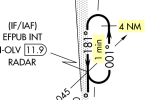
No reason you need both GPS and ground-based DME. What do you mean by "missing waypoint"?With a quick search I found the KRBW ILS Z or LOC Z RWY 23 still shows "GPS and DME required." So in this case it is not a missing Wpt, but still DME required. It is possible that all the ones that just didn't have a fix back inthe day have been revised, but it wouldn't shock me if someone comes up with one local to them.
Peter, for one similar to yours I wrote in about, there's the PBG ILS ORL LOC 35When I see something like this, my first thought is "charting error" because it makes no sense.
I'm pretty sure he's referring to where the chart shows a DME fix likeNo reason you need both GPS and ground-based DME. What do you mean by "missing waypoint"?
 but without naming it.
It doesn't need a name. You can still sub GPS distance.I'm pretty sure he's referring to where the chart shows a DME fix like View attachment 153909 but without naming it.


