Will NGS GPS Shift Affect Aviation?

jnmeade

Cleared for Takeoff
Joined
Sep 25, 2005
Messages
1,280
Location
Eastern Iowa
Display Name
Jim Meade
Home Airfield
Iowa City, IA
In 2026, the National Geodetic Survey (NGS) will implement updated GPS coordinates which will have the effect of changing the numbers on your GPS coordinates by 1-4 meters, according to a piece I read. This is both horizontal and vertical.
As a farmer, I see that I may have to verify that field boundaries and various geospatial records are accurately updated (otherwise, I'll spray my neighbor's petunias or dig too deep and hit my drainage tile line).
What are you hearing about aviation? Will providers correct data automatically so I don't land 2 meters deep at the airport?
I understand - 1 to 4 meters may not be much in many aviation endeavors, but maybe there are some aspects that don't immediately come to mind. A quick search online didn't show any discussion of the GPS shift in aviation circles. Are you hearing anything?
 
First I've heard of this, thanks for bringing it up.
I expect all LPV apprpach data will have to be updated, probably as part of the regular 28 day cycle.

Unrelated, but cars with old nav databases might get a bit confused if the owners don't (or can't) upgrade them.
 
This is an interesting topic. I have not yet heard anything about it at work.

What I do know is that we don't have to flight check an LPV or LP procedure if the coordinates of the runway (and some other things) change by 0.03 seconds or less. Since 0.03 seconds is approximately 0.9 m of latitude, or longitude at the equator (less for latitude as you get further from the equator, obviously.) This leads me to believe that there will be a significant amount of work required. What shape this takes I have no idea.
 
A quick search online didn't show any discussion of the GPS shift in aviation circles.
The FAA has had a system in place for years that deals with GPS and magnetic shifts. I don't recall the name of the program, but its been a topic since GPS was "unscrambled" for civilian use.
 
In 2026, the National Geodetic Survey (NGS) will implement updated GPS coordinates which will have the effect of changing the numbers on your GPS coordinates by 1-4 meters, according to a piece I read. This is both horizontal and vertical.
As a farmer, I see that I may have to verify that field boundaries and various geospatial records are accurately updated (otherwise, I'll spray my neighbor's petunias or dig too deep and hit my drainage tile line).
What are you hearing about aviation? Will providers correct data automatically so I don't land 2 meters deep at the airport?
I understand - 1 to 4 meters may not be much in many aviation endeavors, but maybe there are some aspects that don't immediately come to mind. A quick search online didn't show any discussion of the GPS shift in aviation circles. Are you hearing anything?

I am guessing that the change from NAD83 to 2022 datum can be done through a firmware upgrade, and the resulting changes in the calculated positions can be handled through the regular 28 day FAA update cycle?
 
I wonder what this will do to autonomous vehicles? That includes agricultural drones and equipment, military drone targeting, research drones ...
 
I wonder what this will do to autonomous vehicles? That includes agricultural drones and equipment, military drone targeting, research drones ...

After I heard about this, I looked into this more and watched a few webinars. My understanding is that there will be no change in the way the satellites put out their signals. The change is in how the coordinates are computed by the receiver. So if you have an older receiver, you will continue to get the same coordinates as before, and if you are using it with the older databases, then there will be no change. But if you use an old receiver with new databases or vice versa, then there will be some difference. Since aviation databases are continuously updated, I don't think this is going to cause any operational considerations.
 
But if you use an old receiver with new databases or vice versa, then there will be some difference. Since aviation databases are continuously updated, I don't think this is going to cause any operational considerations.
Are there panel mounted GPS's that are totally unsupported hardware/firmware-wise even though they continue to be able to use new database updates? Could these be a problem in terms of "updating the receiver"? Or is everything needed to adjust for the change contained in the database update?
 
Since aviation databases are continuously updated, I don't think this is going to cause any operational considerations.
I can't speak for big iron performance, but in my little bird I can't imagine that I would notice a 1-4m inaccuracy in my fix, especially en route but even on an approach, so I would say this would not have any operational consideration regardless.
 
I can't speak for big iron performance, but in my little bird I can't imagine that I would notice a 1-4m inaccuracy in my fix, especially en route but even on an approach, so I would say this would not have any operational consideration regardless.
Might make a difference on a WAAS approach. I'd be interested in hearing what the TERPSters have to say...
 
Very good question. Former NGS Geodesist here, and I was working on maintaining GPS station coordinates and orbit analysis.

NGS has been modernizing NAD83 (horizontal frame) and NAVD88 (vertical frame), so this change will mainly affect surveyors and geospatial control.

In aviation, pilots and avionics generally use WGS 84, and FAA procedure/charting practice already treats the differences as operationally negligible. So when the transition happens, it will mostly improve alignment on the survey and data side, while pilots are unlikely to notice much change in everyday GPS navigation.
 
Might make a difference on a WAAS approach. I'd be interested in hearing what the TERPSters have to say...
How so?

My point was that I don't think I can detect a 4m change in position via the needles in my aircraft, nor do I think I control my plane within 4m of my desired flight path. If I flew the same approach 40 times, twenty before the OP's GPS coordinate change and twenty after, I'm not sure you could subsequently look at my paths through the sky and tell which ones used which GPS coordinates. The difference would be "in the noise". And even if you could, I doubt that it would matter in a practical sense--at DH or MAP, if 4m is the difference between landing and going missed, well, I probably shouldn't have been flying that approach that day anyway.

And if I'm right at the limits of my CDI's needle deflection and 4m makes the difference between me safely clearing terrain or crashing into a mountain? Um, I hope there's a little more margin built into these approaches than that.

Now an airliner with 0/0/0 autoland capability? Potentially landing up to 4m off centerline (if that's what this really means)? Maybe that might be a big deal, but I don't know about such things.
 
How so?

My point was that I don't think I can detect a 4m change in position via the needles in my aircraft, nor do I think I control my plane within 4m of my desired flight path.
I bet you can. Full deflection on an ILS at minimums is eight feet.

My thoughts revolve around the protected areas for setting minimums on an LPV, for example, which I think are measured in feet. 4m is about 13 feet, so if things move by that much an obstacle that used to be just outside the protected area could now be within the protected area.

However, I *think* the GPS receiver units might have a model loaded via a database, and updating that database could simply change how the receiver interprets its own position based on the satellite time codes, which would mean that all of the nav data would remain good since it would be placing the airplane in the same location even with the new model.
 
This is going to screw up my lawnmower and it's supposed 10cm accuracy. Darned thing is probably going to hop a curb.
 

Sounds like they'll need to publish in the register before it goes into effect, and there's a 5 year implementation window. It also says if you are using WAAS equipment, you won't notice it as it isn't accurate enough. However local RTK station equipment will see the effects.

At least there's a simple conversion factor for surveying for this one. When those jokers instituted NAD83/88 HARN, there was no calculation to NAD27/NAVD29 and it caused serious issues in my civil engineering world. I guess they learned the lesson that time around and never again base a coordinate system off some dude's farm in Iowa. :p
 
I bet you can. Full deflection on an ILS at minimums is eight feet.

Are you sure about the 8 ft? If I understand correctly, full scale deflection of the GS is +/- 0.7 deg, which at 200 ft height will translate to about +/- 45 ft ( 200/tan(3)*tan(3.7) = 246 )
 
Are you sure about the 8 ft? If I understand correctly, full scale deflection of the GS is +/- 0.7 deg, which at 200 ft height will translate to about +/- 45 ft ( 200/tan(3)*tan(3.7) = 246 )
Maybe it was 8 feet per dot. But if you can fly an ILS within 2 dots, as all instrument pilots should be able to, you can definitely control the path of your airplane to 4m accuracy.

AKA, Pilots: We're freakin' superheroes. :D
 
I bet you can. Full deflection on an ILS at minimums is eight feet.
No, it's not.

Are you sure about the 8 ft? If I understand correctly, full scale deflection of the GS is +/- 0.7 deg, which at 200 ft height will translate to about +/- 45 ft ( 200/tan(3)*tan(3.7) = 246 )
No, it's not.

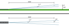
Glideslope full needle deflection occurs when the aircraft is 0.7deg above or below the centerline.
Localizer full needle deflection occurs when the aircraft is 2.5deg left or right of the centerline.

At 1nm or 6000' from the runway (well, from the ILS transmitter to be precise, but cut me some slack here), with a .7deg angle, the glideslope full deflection from center would be 6000' * tan(.7deg) = 73'. 4' is about 5% of that. That's ~1/20th of full deflection. At 3000' from the runway, it'd be ~1/10 of full deflection.

At 6000' from the runway, with a 2.5deg angle, localizer full deflection would indicate 6000' * tan(2.5deg) = 262'. 4' is about 1.5% of that. That's ~1/65 of full deflection. At 3000' from the runway, it'd be ~1/33 of full deflection.

4' of position difference at DH/MAP is just not practically significant in my aircraft.
 
Last edited:
Maybe it was 8 feet per dot. But if you can fly an ILS within 2 dots, as all instrument pilots should be able to, you can definitely control the path of your airplane to 4m accuracy.

AKA, Pilots: We're freakin' superheroes. :D

That sounds more reasonable. If there are 5 dots on each side, 45 ft/5 is 9 ft. However, this is at an LPV minimum of 200 ft. Further away, the each dot would translate to a larger altitude difference. So, I agree, the 4m potential error is not likely to make a difference.
 
That sounds more reasonable. If there are 5 dots on each side, 45 ft/5 is 9 ft. However, this is at an LPV minimum of 200 ft. Further away, the each dot would translate to a larger altitude difference. So, I agree, the 4m potential error is not likely to make a difference.
No. 200 ft AGL isn't a part of the calculation. The angle extends from the runway (actually the localizer or glideslope transmitters), not from the ground. The only way 200' is relevant is to look at an approach and see how far you are from the runway(transmitter) at 200' (or whatever your DH/MAP is).

1776978418803.png

(Please no mathematician gripes about my drawings not being perfect--they're close enough for the purposes of this discussion.)
 
Last edited:
No. 200 ft AGL isn't a part of the calculation. The angle extends from the runway (actually the localizer or glideslope transmitters), not from the ground. The only way 200' is relevant is to look at an approach and see how far you are from the runway(transmitter) at 200' (or whatever your DH/MAP is).

View attachment 151655

(Please no mathematician gripes about my drawings not being perfect--they're close enough for the purposes of this discussion.)

Where is the 3000' lateral distance coming from? Is that part of the ILS/LPV spec?
 
Where is the 3000' lateral distance coming from? Is that part of the ILS/LPV spec?
No. It's just approximately half a nautical mile, which is about as close as a DH point or MAP will be to the runway threshold. You'll be visual the rest of the way down from there (or else going missed) so GPS accuracy beyond that point doesn't matter. (Unless you're in an airliner flying a 0/0/0 autoland approach, which as I've previously said I know nothing about.)
 
Very good question. Former NGS Geodesist here, and I was working on maintaining GPS station coordinates and orbit analysis.

NGS has been modernizing NAD83 (horizontal frame) and NAVD88 (vertical frame), so this change will mainly affect surveyors and geospatial control.

In aviation, pilots and avionics generally use WGS 84, and FAA procedure/charting practice already treats the differences as operationally negligible. So when the transition happens, it will mostly improve alignment on the survey and data side, while pilots are unlikely to notice much change in everyday GPS navigation.
awesome answer right from the source, thanks. if I could ask you a related question: you mention survey equipment. I see modern surveyors using GPS equipment to measure even small residential lots .... how accurate can their equipment be compared to aircraft WAAS tech we use? I fly a modern get with auto land capabilities that uses several inputs to do it, GPS just being one, with ILS being primary. As talk of eliminating expensive ground based nav aids begins and ILS becomes extinct, GPS likely to play a bigger part in such precision approaches. wondering just how accurate such equipment can be.

satellite surveys were game changers for much of the world for aviation safety..... in the 1980s satellites were used to map topography in South America. when done, much of the published max altitudes were much higher than original old fashioned survey charts, and thus safe altitudes depicted on aeronautical charts were really lower than actual....some significantly. But because the US didn't have the right to change/correct foreign charts, our charts indicated the original official grid MORA with a line through it and our satellite derived new min safe altitude.

When I was flying down there in the 1990s old captains said they knew not to fully trust the charts and were hesitant to get off a well used,/proven airway MEA to deviate around wx...they figured if it was wrong someone prior would have demonstrated it long before.

There was a Eastern Airline b727 that deviated off an airway coming into Bolivia mid 1980s that tragically crashed believed to be a victim of bad chart info, at least at that time all, a belief held by interested parties as ALPA and Boeing. this accident played a significant role in Allied Signals company GPWS development which uses GPS derived elevations data based and mixed it with aircraft position and aircraft heading and altitude.... likely the most significant safety feature in decades... becoming basic equipment on most new aircraft as well as required installation on existing fleets. It alerted the now familiar TERRAIN. TERRAIN, PULL UP! warning. My father in law worked on it.

charts may still have the crossed out altitudes, haven't looked lately.
 
RTX is less than an inch horizontally and a couple of inches vertically.
 
awesome answer right from the source, thanks. if I could ask you a related question: you mention survey equipment. I see modern surveyors using GPS equipment to measure even small residential lots .... how accurate can their equipment be compared to aircraft WAAS tech we use? I fly a modern get with auto land capabilities that uses several inputs to do it, GPS just being one, with ILS being primary. As talk of eliminating expensive ground based nav aids begins and ILS becomes extinct, GPS likely to play a bigger part in such precision approaches. wondering just how accurate such equipment can be.

satellite surveys were game changers for much of the world for aviation safety..... in the 1980s satellites were used to map topography in South America. when done, much of the published max altitudes were much higher than original old fashioned survey charts, and thus safe altitudes depicted on aeronautical charts were really lower than actual....some significantly. But because the US didn't have the right to change/correct foreign charts, our charts indicated the original official grid MORA with a line through it and our satellite derived new min safe altitude.

When I was flying down there in the 1990s old captains said they knew not to fully trust the charts and were hesitant to get off a well used,/proven airway MEA to deviate around wx...they figured if it was wrong someone prior would have demonstrated it long before.

There was a Eastern Airline b727 that deviated off an airway coming into Bolivia mid 1980s that tragically crashed believed to be a victim of bad chart info, at least at that time all, a belief held by interested parties as ALPA and Boeing. this accident played a significant role in Allied Signals company GPWS development which uses GPS derived elevations data based and mixed it with aircraft position and aircraft heading and altitude.... likely the most significant safety feature in decades... becoming basic equipment on most new aircraft as well as required installation on existing fleets. It alerted the now familiar TERRAIN. TERRAIN, PULL UP! warning. My father in law worked on it.

charts may still have the crossed out altitudes, haven't looked lately.
That’s a common question, and my answer is usually: it depends.

Real-time positioning is always less accurate because you have to rely on broadcast or predicted orbit/clock information. With survey-grade GNSS, real-time RTK or network RTK can usually get down to about 2-5 cm under good conditions.

But when surveyors bring the data back to the office, they can post-process it with better orbit products. Rapid daily orbits become available later (usually 1700 UTC next day), and the best results come from final orbit products, which take about two weeks. That can bring the solution closer to the 1-3 cm range, with horizontal usually better than vertical.

The length of the observation also matters a lot. A few minutes may be fine for routine work, but for high-precision work we usually want at least 4 hours. 12-24 hours is even better. On a good stable day, horizontal repeatability can sometimes approach the millimeter level, but that’s more for ideal geodetic work than ordinary lot surveys.
 
No. 200 ft AGL isn't a part of the calculation. The angle extends from the runway (actually the localizer or glideslope transmitters), not from the ground. The only way 200' is relevant is to look at an approach and see how far you are from the runway(transmitter) at 200' (or whatever your DH/MAP is).

View attachment 151655

(Please no mathematician gripes about my drawings not being perfect--they're close enough for the purposes of this discussion.)

I'm still not following why the 200' is not part of the calculation, but the 3000' is. The TERPS criteria specifies 200' for LPV/ILS, but it does not mention 3000'. The geometry is the same whether you work from the veritcal offset of 200' from the TDZE or the lateral offset from the runway threshold.
 
Not sure if the Datum(s) being changed will affect aviation. But even if it does, you simply need to update the DB. If the physical location changes by +.001 (or whatever) the new DB has the location now updated by +.001.

It is not as if we're still using paper charts and you might pick up an old chart with the wrong coordinates. Your GPS will have been adjusted to show the at xxx.001 vs xxx.000. And gee... if there only were a rule that says you must have a current DB to fly IFR...
 
Back
Top