Why Do Ships Measure Speed In Knots? - Jalopnik
The answer goes back to Dutch sailors in the 1600s who tied knots in a rope tied to a log, then observed how fast their ship moved past them.
 www.jalopnik.com
 www.jalopnik.com


That's because until a clock was invented, there was no way to accurately measure latitude/longitude, altho the ancient Greeks did have some basic measurements based on distance.Yet the article never explains that a nautical mile is a minute of latitude.


From Wiki:So, just a coincidence that the knot is a nautical mile per hour, equal to one minute of latitude? Or was the distance between knots (and therefore the nautical mile) adjusted after lat/lon had been invented? In other words, is a knot today the same as a knot in the 1500s?

Ships use nautical Knots, of course.Metric or Imperial Knots?

You need an accurate clock to measure longitude, but latitude doesn't require a clock (though a clock makes it easier or quicker).That's because until a clock was invented, there was no way to accurately measure latitude/longitude, altho the ancient Greeks did have some basic measurements based on distance.
History of longitude - Wikipedia
en.wikipedia.org

And is that square knots, overhand knots, arbor knots, half hitch knots, slip knots?Metric or Imperial Knots?
And is that square knots, overhand knots, arbor knots, half hitch knots, slip knots?
Knotts Berry Farm, too.You left out Don Knotts.

I was kind of blown away when I learned that. Makes all other units of distance measurement/speed seem arbitrary and silly. At least on this planet.Yet the article never explains that a nautical mile is a minute of latitude.

The meter traces back to a physical property of the planet as well.I was kind of blown away when I learned that. Makes all other units of distance measurement/speed seem arbitrary and silly. At least on this planet.

10,000,000 meters from the equator to the polesI was kind of blown away when I learned that. Makes all other units of distance measurement/speed seem arbitrary and silly. At least on this planet.

Knots, Knots?
Whose there?
Who?Miles.
Also left out forget-me-knots and why knotsYou left out Don Knotts.
Knot really for us to say.....Also left out forget-me-knots and why knots
Who?
Thought it might be the Miles with the trumpet.Miles Standish, of course, and Happy Thanksgiving to you!
Prior to the chronograph (mid-1700s) there wasn’t a practical way to find longitude aboard ship. The time component could be calculated based on the position of the moons around Venus, or something like that, but a time component is required to find longitude accurately. Latitude is relatively easy, and a chip log could give an estimate of distance traveled on a particular course so that a guesstimate of longitude could be made.I would imagine that the chip log came along after the 1500s. Before that, the navigators would get their lat-long positions using astronomical observations, and the distance travelled in x hours would give x speed.


If you said "easy", it would be more correct. Lunar observations became practical at about the same time. The angle between the moon and something else in the sky also provides a time. See: https://www.starpath.com/resources2/brunner-lunars.pdfPrior to the chronograph (mid-1700s) there wasn’t a practical way to find longitude aboard ship. The time component could be calculated based on the position of the moons around Venus, or something like that, but a time component is required to find longitude accurately. Latitude is relatively easy, and a chip log could give an estimate of distance traveled on a particular course so that a guesstimate of longitude could be made.


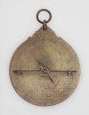
About the only certified panel GPS I can afford to clean install these days lol......Latitude - Astrolabe from the 9th century C.E. (https://en.wikipedia.org/wiki/Astrolabe)
View attachment 146899
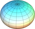
And at longitude at the equator in theory, except the earth is an oblate sphere representing an M&M.Yet the article never explains that a nautical mile is a minute of latitude.
The nautical mile was defined as 1 minute of latitude in the begining, and then slightly adjusted. Coordinates started to be used for navigation in the 15th century, and the first logs started being used towards the end of that century. Initially they used a 5000-ft mile and no knots, before standardizing on using 1/60th of a degree of latitude as a definition for the nm and tying knots on the log line accordingly.So, just a coincidence that the knot is a nautical mile per hour, equal to one minute of latitude?