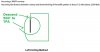
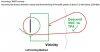
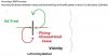
Is it correct that your preferred approach of flying around the field, or circling left, is based on the old diagram you linked in post 58, this one?:
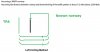
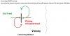
If so, does that mean that when approaching a nontowered field, you believe you should always do Approach A and not Approach B?:
The diagram is based on 91.126, which is where I draw my conclusions. To the extent it depicts 91.126 accurately, I agree with it. But the drawing is not to scale, so literally following the flight path doesn't work. It's more of a 3-D birdseye view where the large circle is a path through the air high above the ground. That view, though, breaks down when you look at the rectangular pattern "within". So, I only cite the drawing as a way to show FAA thinking when the rule was much younger and fewer planes had radios: Circle left, look for other traffic and wind direction, enter the pattern from the outside or descend on the upwind side and merge with closed traffic. You don't descend where you show.
While it doesn't explicitly say it should be done while crossing midfield above TPA, I read
FAA Advisory Circular AC No. 90-66A (1993) (see 8a on p.2) as strongly supporting Approach B by saying that you should fly
above TPA to check wind and landing direction indicators to determine the traffic pattern direction and then proceed to a point well clear of the pattern before descending to pattern altitude:
In theory, that's a reasonable plan of action. To the extent you fly far enough to leave the "vicinity" (often 5 miles in other context, such as class D) it would comply with 91.126. However, in practice pilots are too impatient and wind up making a descending 180° while still within what another pilot might define as the downwind leg. I think stopping the practice altogether would work better than trying to get pilots to agree on the amount of patience required. You don't need to define "vicinity" if you simply orbit to the left and join the pattern on the upwind or a 45 to the down wind or join on a properly flown crosswind.
Assuming my understanding of Approach A is correct, I have two questions --
(1) Is it practical to use Approach A to check wind and landing direction indicators?
I don't know the answer because, in my limited experience, all of the nontowered fields I have visited had automatic weather observation systems so I knew the wind direction before I got there.
Sure it is, remembering the limitations of the drawing. You aren't really trying to circle at three miles (or whatever). Remember, wind isn't the only reason or even the most important one--other traffic is what you're looking for mainly. You don't want to land head-on with somebody who can't read a sock.
(2) If you were approaching from the opposite side of the downwind for a runway that had left traffic for one landing direction and right traffic for the other such that the two possible downwinds were on the same opposite side of the runway, how would you know which way to circle in the first place unless you flew over the field above TPA and observed the windsock?
Circle left. Then you must depart and reapproach at the proper altitude to join the downwind (on a 45). Note that in that case your turn back toward the airport would be left again, then another left entering traffic before making right hand turns in the pattern. I hate these airports unless justified by obstacles. "Aircraft noise" isn't good enough for me.
Thank you for carrying on a civil dialog. It shows it can be done.

dtuuri






 . I got it backwards when writing the textual description to MAKG1.