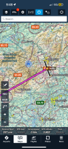
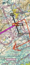
At my MIL (drove this trip) and started planning future flights. To fly from KAVL to KBHM, there is a 7k ft mountain just West of the field right in the flight path. If departing Rnwy 35 VFR, would you have to fly all the way north past the mountains before turning west, or is there a way to request vectors or a flight path that turns back south to get past the mountain? I’m based on the coast

You are using an out of date browser. It may not display this or other websites correctly.
You should upgrade or use an alternative browser.
You should upgrade or use an alternative browser.
Mountain Flying KAVL
- Thread starter teethdoc
- Start date

eman1200
Touchdown! Greaser!
I'd take a closer look at the flight path directly from avl to bhm. unless you're flying something silly like a high wing, you should have no prob clearing stuff. also, the avl airspace is pretty narrow east to west, u can just cancel and do your own thing. but based on what I see it's not a big deal. will just most likely be bumpy.
eman1200
Touchdown! Greaser!
jeez dude you'll be at 20k' before turning crosswind, sheesh. no concerns, and if for some reason you still have concerns, it's not like the controllers don't know they're in the mountains, and will be perfectly accommodating to whatever your needs are. which in a J shouldn't be much.I fly a mooney m20j


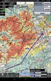
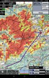
I’ve crossed that at 9,500 no problem. You can always go south and then west and 8,500 will work fine that way.To fly from KAVL to KBHM, there is a 7k ft mountain just West of the field right in the flight path.

Mahneuvers
Pattern Altitude
- Joined
- Nov 3, 2020
- Messages
- 1,665
- Display Name
- Mahneuvers


AlleyCat67
Pre-takeoff checklist
- Joined
- Oct 5, 2017
- Messages
- 485
- Display Name
- AleyCat67
- Home Airfield
- 20N
Flying out of KROA heavily loaded I’ve asked for a 360 to clear terrain and have gotten it. That’s another option,

Jim Carpenter
Line Up and Wait
Even if not IFR rated, it can be extremely helpful to familiarize yourself and review any published instrument departure procedures, such as:
Those may or may not be more than necessary for a VFR flight, but following will assure terrain clearance.
Those may or may not be more than necessary for a VFR flight, but following will assure terrain clearance.

- Joined
- May 25, 2006
- Messages
- 21,997
- Location
- KTTA, North Carolina
- Display Name
- Who you kiddin?
- Home Airfield
- KTTA
In the formal instrument flight world, it's a VCOA, but circling above an airport to clear terrain before continuing enroute is also a standard VFR technique I first learned as a student pilot.Flying out of KROA heavily loaded I’ve asked for a 360 to clear terrain and have gotten it. That’s another option,

- Joined
- Mar 15, 2016
- Messages
- 5,585
- Display Name
- Ari
I’m far from a local so my thoughts should be taken with multiple grains of salt. But I would probably climb straight out on 35 until 7,000 MSL or so and then turn direct to the destination, cruising at 8,500 or 10,500 (which are also my typical cruising altitudes for a flight of that distance over flat terrain; it’s a very strange concept for me to cruise below 5,000). Or maybe ask for a downwind departure and climb on a heading of about 190, otherwise the same plan (turn after 7,000 and cruise 8,500 or 10,500).
VFR, I probably wouldn’t ask for vectors or flight paths, or anything other than a takeoff clearance with an initial direction of flight. And I probably wouldn’t go all the way around the Blue Ridge Mountains unless they were creating serious turbulence or clouds that I wanted to avoid.
IFR, and looking only at the en route chart and not any departure or arrival procedures, I think I would file KAVL FREEZ T414 MILBY T484 NELLO V417 VUZ KBHM at 10,000.

flyingcheesehead
Taxi to Parking
- Joined
- Feb 23, 2005
- Messages
- 28,184
- Location
- UQACY, WI
- Display Name
- iMooniac
- Home Airfield
- KUES/KMKE
This!!!!Even if not IFR rated, it can be extremely helpful to familiarize yourself and review any published instrument departure procedures, such as:
Those may or may not be more than necessary for a VFR flight, but following will assure terrain clearance.
That document states the following:
DEPARTURE PROCEDURE:
Rwy 17, climb heading 167° to 4500 before proceeding on course.
Rwy 35, climb heading 347° to 5500 before proceeding on course.
And that is your answer.
- Joined
- May 25, 2006
- Messages
- 21,997
- Location
- KTTA, North Carolina
- Display Name
- Who you kiddin?
- Home Airfield
- KTTA
Ultimately and if unfamiliar, yes, published instrument departures, whether SID or ODP provide broad terrain and obstruction separation. Whether using them is really necessary for VFR is a different - and interesting - question.This!!!!
That document states the following:
DEPARTURE PROCEDURE:Rwy 17, climb heading 167° to 4500 before proceeding on course.Rwy 35, climb heading 347° to 5500 before proceeding on course.And that is your answer.
flyingcheesehead
Taxi to Parking
- Joined
- Feb 23, 2005
- Messages
- 28,184
- Location
- UQACY, WI
- Display Name
- iMooniac
- Home Airfield
- KUES/KMKE
Certainly not "necessary" but I would argue that they absolutely should be used for night VFR unless you're familiar with the area. Rocks aren't lit...Ultimately and if unfamiliar, yes, published instrument departures, whether SID or ODP provide broad terrain and obstruction separation. Whether using them is really necessary for VFR is a different - and interesting - question.
And, they'll pretty well keep you out of trouble. It may be tempting to just fly close to the rocks and not hit them, but I would advise against it unless you've had a mountain flying course. The IFR departure procedure is going to put you in a position to be able to clear the terrain by at least a thousand feet, two thousand in a designated mountainous area. While that isn't a "get out of downdraft jail free" card, it'll give you a reasonable margin to start with. And it's better than SGOTI.
- Joined
- May 25, 2006
- Messages
- 21,997
- Location
- KTTA, North Carolina
- Display Name
- Who you kiddin?
- Home Airfield
- KTTA
Definitely agree.Certainly not "necessary" but I would argue that they absolutely should be used for night VFR unless you're familiar with the area. Rocks aren't lit...

- Joined
- Jun 7, 2008
- Messages
- 2,261
- Display Name
- Andrew, CFI-I
At my MIL (drove this trip) and started planning future flights. To fly from KAVL to KBHM, there is a 7k ft mountain just West of the field right in the flight path. If departing Rnwy 35 VFR, would you have to fly all the way north past the mountains before turning west, or is there a way to request vectors or a flight path that turns back south to get past the mountain? I’m based on the coast
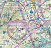
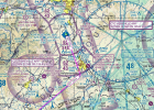
I think you are making it more complicated than it has to be. I would just ask for a downwind departure to the south, and then turn southwest to keep you clear of all the mountains. There is also a T414 airway if you prefer. The only thing to worry about along that route are a couple of very tall antennas.
Attachments
flyingcheesehead
Taxi to Parking
- Joined
- Feb 23, 2005
- Messages
- 28,184
- Location
- UQACY, WI
- Display Name
- iMooniac
- Home Airfield
- KUES/KMKE
OK, @teethdoc, I like planning flights almost as much as I like flying 'em, so here goes...
Obviously, punching in direct KAVL-KBHM is no bueno which is why you asked in the first place. I think @sarangan has an excellent suggestion above - Fly to the southeast and join the T414 airway southwest. Fly until you're comfortable going direct...
Or, if you'd like a full route that keeps you away from terrain and airspace the whole time, try KAVL FREEZ T414 MILBY T484 NELLO V417 MAYES direct KBHM at 6500 or above (I'd do 8500 myself):

Obviously, punching in direct KAVL-KBHM is no bueno which is why you asked in the first place. I think @sarangan has an excellent suggestion above - Fly to the southeast and join the T414 airway southwest. Fly until you're comfortable going direct...
Or, if you'd like a full route that keeps you away from terrain and airspace the whole time, try KAVL FREEZ T414 MILBY T484 NELLO V417 MAYES direct KBHM at 6500 or above (I'd do 8500 myself):
eman1200
Touchdown! Greaser!
….Obviously, punching in direct KAVL-KBHM is no bueno….
Can you explain why not, with some very minor deviations?
flyingcheesehead
Taxi to Parking
- Joined
- Feb 23, 2005
- Messages
- 28,184
- Location
- UQACY, WI
- Display Name
- iMooniac
- Home Airfield
- KUES/KMKE
Because minor deviations aren't direct.Can you explain why not, with some very minor deviations?

But yeah, at 6000 direct my profile view showed two splats early in the flight. Adding FREEZ alone does keep you from going splat, but only clears obstacles by 520'.

It's not like the OP is in a c-150 on a summer afternoon with his wife's luggage for a weeks vacation. More concerning than routing around the hills in the area would be weather. For the uninitiated, I would try to plan a day or time for less wind and turbulence with good visibility and cloud separation.
eman1200
Touchdown! Greaser!
Because minor deviations aren't direct.
But yeah, at 6000 direct my profile view showed two splats early in the flight. Adding FREEZ alone does keep you from going splat, but only clears obstacles by 520'.
Try plugging in a VFR altitude and see what happens.
- Joined
- May 25, 2006
- Messages
- 21,997
- Location
- KTTA, North Carolina
- Display Name
- Who you kiddin?
- Home Airfield
- KTTA
Asking for a departure to the south when heading to the south is waaaay too obvious. It’s aviation. It supposed to be complicated.I think you are making it more complicated than it has to be. I would just ask for a downwind departure to the south, and then turn southwest to keep you clear of all the mountains.
flyingcheesehead
Taxi to Parking
- Joined
- Feb 23, 2005
- Messages
- 28,184
- Location
- UQACY, WI
- Display Name
- iMooniac
- Home Airfield
- KUES/KMKE
Well, there's seven splats at 4500.Try plugging in a VFR altitude and see what happens.

- Joined
- Mar 15, 2016
- Messages
- 5,585
- Display Name
- Ari
I count one splat. That's the maximum number of splats in a single flight.Well, there's seven splats at 4500.