Let Discuss Flying in Scattered Thunderstorms

The other day I flew TOP->NEW dealing with both a frontal line and the usual pop-up T-storms. My flight path looks like a drunken sailor was flying the airplane, with multiple deviations and at one point doing a 180 and landing at ADF to wait out a line to break up. My son slept most of the way in the back, we remained in VFR conditions nearly the entire time, and I could’ve had a full cup of coffee on the dash and not spilled a drop because the ride was so smooth. The key is flexibility in planning, having good communication with ATC, always leaving yourself an out, not flying into the buildups, and being willing to turn around and wait it out if necessary.
 
As an relatively new pilot with a <1 year old instrument ticket, I've been watching this thread with interest.

My experience thus far has been that ADSB is rarely more than a few minutes old, and correlates very well with what I see out the window. I understand that there may be processing delays not reflected in the delay displayed on the screen, but the times I've had to dodge cells it's been very good.

A couple weeks ago:
upload_2021-6-24_14-22-53.png

I was about to divert west, but when I got to Bloomington, I could see Champaign, and never got wet. ATC was extremely helpful as well letting me know that the hole I was seeing on adsb showed on their scope as well.

I did penetrate a few tall clouds, but they were skinny and not producing rain. Aside from being bumpy, it wasn't an issue. Should I be avoiding these? How far from your flight path can you deviate around cells without permission? I could have stayed completely out of the clouds on this trip, but didn't want to pester atc every few minutes.
 
As an relatively new pilot with a <1 year old instrument ticket, I've been watching this thread with interest.

My experience thus far has been that ADSB is rarely more than a few minutes old, and correlates very well with what I see out the window. I understand that there may be processing delays not reflected in the delay displayed on the screen, but the times I've had to dodge cells it's been very good.
I agree. Leslie and I recently flew from Florida to Nevada and back and had to dodge, wait out or beat several weather fronts. ADSB was very helpful, as long as you understand it's latencies and double check it while looking out the window. That said, I wouldn't rely on ADSB to dodge weather in IMC. Oh, we also have a Strikefinder, which a lot of people disparage, but I would feel naked without it at times.
 
As an relatively new pilot with a <1 year old instrument ticket, I've been watching this thread with interest.

My experience thus far has been that ADSB is rarely more than a few minutes old, and correlates very well with what I see out the window. I understand that there may be processing delays not reflected in the delay displayed on the screen, but the times I've had to dodge cells it's been very good.

A couple weeks ago:
View attachment 97620

I was about to divert west, but when I got to Bloomington, I could see Champaign, and never got wet. ATC was extremely helpful as well letting me know that the hole I was seeing on adsb showed on their scope as well.

I did penetrate a few tall clouds, but they were skinny and not producing rain. Aside from being bumpy, it wasn't an issue. Should I be avoiding these? How far from your flight path can you deviate around cells without permission? I could have stayed completely out of the clouds on this trip, but didn't want to pester atc every few minutes.

You can always ask for permission to deviate-/+20° as necessary.
I would never go IMC in active thunderstorm area, and would have just gone around it all. I have a fast plane, I don’t mind the extra miles.
 
I just flew a round trip from Texas to Illinois last weekend. Lines of thunderstorms both ways. I planned way out in advance, and diverted well east to keep at least 50 miles out ahead of them. On the way home I was afraid of a storm that seemed to be popping up just west of my home airport. I actually made an extra stop for fuel about two hours from home and let that storm decide if it was going to build. It ended up being a typical quick pop up storm that lasted about 15 minutes and went away completely. Landed at the home drone with clear skies, albeit, windy as hell with a 20 knot crosswind.
 
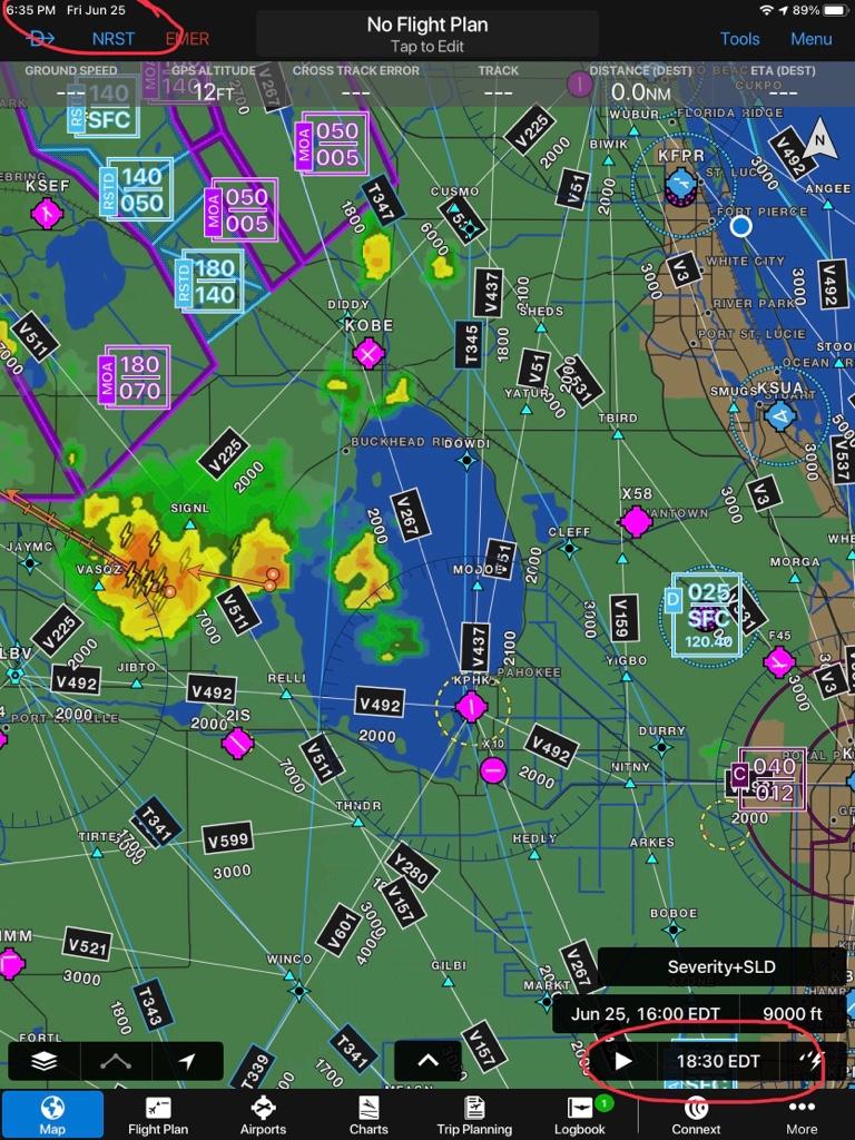
I would disagree with the ADSB only being minutes behind. Here are some "live shots" of some rain showers. First out my left side:

upload_2021-6-25_17-13-39.png

Then my right:

upload_2021-6-25_17-14-14.png

Now the ADS-B

upload_2021-6-25_17-14-48.png

What you are seeing out the windows, is what is showing BEHIND the plane on the iPad. That blob on the iPad directly behind the plane is what is out the right, and that blob on the iPad behind and way to the left is what is showing out our left (storms were tracking left to right). That's quite a bit behind what's actually happening (I'd estimate at least 15, but probably more like 25, minutes).
 
Last edited:
I would disagree with the ADSB only being minutes behind. Here's some "live shots" of some rain showers. First out my left side:

View attachment 97653

Then my right:

View attachment 97654

Now the ADS-B

View attachment 97655

What you are seeing out the windows, is what is showing BEHIND the plane on the iPad. That blob directly behind the plane is what is out the right, and that blob behind and way to the left is what is showing out our left (storms were tracking left to right). That's quite a bit behind what actually happening (I'd estimate at least 15, but probably more like 25, minutes).
That's interesting. I wish I had taken pictures on my last couple flights as they would show the cells exactly where nexrad indicated. Certainly proves the point that you can't rely on it if you can't visually verify it.
 
I would disagree with the ADSB only being minutes behind.
What you are seeing out the windows, is what is showing BEHIND the plane on the iPad. That blob directly behind the plane is what is out the right, and that blob behind and way to the left is what is showing out our left (storms were tracking left to right). That's quite a bit behind what actually happening (I'd estimate at least 15, but probably more like 25, minutes).

There are timestamps that will give you an idea when the radar was completed, but it could be 10 minutes older.
0af1803d1849b663510e552328556340.jpg
 
There are timestamps that will give you an idea when the radar was completed, but it could be 10 minutes older.
0af1803d1849b663510e552328556340.jpg
I could be wrong, but isn't that timestamp the download time, not the image time? I seem to recall that those numbers can be quite a bit behind.

EDIT: Re-reading I see now you mention "...could be 10 minutes longer"
 
Last edited:
As several people have noted, if you aren’t willing to fly when there are thunderstorms in the area, you won’t fly in the Southeast USA / Florida during the summer.

I try to schedule flights in the morning when I can, but sometimes that isn’t possible. In those instances, I try to get high fast so that I am above most of the weather and can get around what I cannot get over. I cycle between satellite weather and weather radar frequently when near storms and I aggressively deviate to avoid build ups. When I don’t like the route because of the weather, I pick another route and request it, even if it adds time. When the east coast arrival in Florida has weather, very often the west coast arrival will look better.

in the case below, it was a short trip from Tampa to Ft. Lauderdale and you can see there was weather on the arrival. Since it was short, I couldn’t get above it. I was shooting for the gap between the cells but it started to close. I ended up deviating west of the weather down to Naples, and headed for another gap that was just IMC and rain. It was a relatively smooth trip through the weather and once I got through, the rest of the trip was uneventful.

C772D141-C5FB-4F4C-BEEE-2E509C3E7588.jpeg


Much like others on here, I have found myself in weather that I didn’t want to be in and it isn’t fun at all! The best plan is to avoid it. I hope that is helpful.

Abram Finkelstein
N685AS
 
Everyone gets excited about a thunderstorm here. In 25 years I can remember maybe 2 thunderstorms. Low clouds, rain and MVFR conditions are all to common in SE AK

I have overnighted several times on cross country fights in the lower 48. I don't mess with mother nature...:rolleyes:
 
I’ve landed and waited it out more than I wish but I’ve never been caught in it. I’m still new and this is some solid info here. I’m in the southeast so this is, as said several times, part of the equation. My experience with adsb weather has always been behind the actual, sometimes frustratingly so.
 
I would disagree with the ADSB only being minutes behind. Here's some "live shots" of some rain showers. First out my left side:

View attachment 97653

Then my right:

View attachment 97654

Now the ADS-B

View attachment 97655

What you are seeing out the windows, is what is showing BEHIND the plane on the iPad. That blob on the iPad directly behind the plane is what is out the right, and that blob on the iPad behind and way to the left is what is showing out our left (storms were tracking left to right). That's quite a bit behind what's actually happening (I'd estimate at least 15, but probably more like 25, minutes).
Absolutely right. SiriusXM suffers from the same lag (up to 20 min; the tinestamp for the radar imagery is when it was processed and transmitted over the network, not when it was actually observed).

With slow-moving and slowly-developing systems, no big deal; but with fast-moving systems, fast-building cells, terrain effects, etc, Nexrad (from any source) is an historical view.

Like others have said, use FIS-B or SiriusXM for strategic weather avoidance ("looks bad over the southern half of Michigan") not tactical avoidance ("I see a gap between Flint and Kalamazoo").
 
If you're flying a long XC in the summer in a single engine w/o oxygen, you'd better have time on your hands. The old saying about only flying yourself if you have time to spare rings true. Remember that when thunder boomers pop up, you have to give them a wide berth. I was more than 3 miles from the edge of a big storm in the SW and got tossed like a rag doll in my Maule. Stuff in the aft baggage area wound up in the front seat. I was flying a leg from Santa Fe to Norman Oklahoma and wound up in North Platte, Nebraska. That's how far out of my way I had to go to find my way around a line of imbedded thunder boomers that emerged after my departure in clear air. Fortunately, I did have time to spare and North Platte was a nicer place than I expected. The next day, the weather to the south of me was still ugly, but I had an uneventful flight home to Virginia from there.
 
I would dearly love to have some form of in cockpit wx. But as it stands, all I have is a comm radio, and my own eyeballs. I fly VFR, and have found that the best way for me is to "see and avoid", or land and wait. (no reason not to do that when IFR as well where Tstorms are concerned) I've done both. ATC cannot see clouds, they can see rain. A report of precip does not allways equal T storm, But a report of precip, and you seeing a 40,000' tower does. ;) I need to avoid clouds in order to stay within VFR. in the hot humid south summer, those clouds will get big and nasty fairly quick. I use FF on longer trips, which is not really much help where wx is concerned, but I can hear if other folks in the same sector are deviating due to wx. My best resource is AWOS/ASOS while enroute. It allows me to see a trend in pretty much real time. second is call to FSS for an update. I've also found help when I've had to land and wait, By asking a departing regional pilot to report back with base and tops, while climbing out. They are usually happy to help. And by looking at the weather on the NOAA site.
Another thing to do is to learn about different types of clouds. Those innocent puffy white ones that you see floating around at your altitude are cumulus, and as innocent as they may seem, your ride will be bumpy should you fly through one, and they can turn nasty in a hurry. Stratus OTOH cover a pretty large area and are fairly smooth should you happen to fly into/through it.
 
For those running ForeFlight I’ve found a really useful source of info for trying to figure out how likely t-storms are. If you go under TAF info for an airport you’ll see this Forecast Discussion button.

You’ll find a text description of what the weather forecasters think is happening and how likely/unlikely storms and timing will be. Probably is available somewhere on the NWS site too but I imagine this is how most of are checking these days.

4818543B-152B-47F2-8D5C-51DB76CFA48A.jpeg

894C945A-0186-42A4-A07E-0AC2B841191A.jpg
 
Lots of good advice. I had both a stormscope and XM. I’d also go as high as feasible (but under 20K), and travel IFR to be in the system whenever possible. NEXRAD could let you know whether it were cells or a line and by wathching the trend I had a decent idea which direction they were moving (winds aloft helped, too) and whether or not new ones were popping up.

If it was a line or growing fast, time to get on the ground or just not launch. I recall riding along the front of a squall line from SSF to RBD and trying to beat the line in to make a dinner meeting. Knew it was going to be close. ATC closed all of the regional airspace when I was about 10 miles south of Lancaster and asked for my intentions. I immediately diverted to Lancaster, got it on the ground and tied down… the squall line hit just as I walked into the FBO. They arranged a rent car and I left the plane there for the night. N retrospect I might not have made RBD, so I made the right call. A little to close for comfort, though. A lesson was learned.
 
As has been said, if you’re not willing to fly with some weather that you need to dodge, summer flying may be a bit of a challenge. Especially in Florida.
Keep in mind I’m not advocating trying to penetrate a solid line.
 
As has been said, if you’re not willing to fly with some weather that you need to dodge, summer flying may be a bit of a challenge. Especially in Florida.
Keep in mind I’m not advocating trying to penetrate a solid line.
Or, as others have mentioned, learn to be an early riser. Getting out of bed at 4:30 am sucks, but arriving at the airport at 5:30 am on a summer morning is one of the most magical times for flight. In most parts of Canada and the U.S., the only thunderstorms at that time of day will be frontal.
 
Or, as others have mentioned, learn to be an early riser. Getting out of bed at 4:30 am sucks, but arriving at the airport at 5:30 am on a summer morning is one of the most magical times for flight. In most parts of Canada and the U.S., the only thunderstorms at that time of day will be frontal.

Agree, with the caveat that in central and south Florida, overnight offshore breezes can sometimes lead to storm cell development over the water that drift onshore in the morning, leading to two-a-days. Tampa Bay is the lightning capital of the US for a reason. Morning fog can be a thing too. I've had the most consistent luck from about 10 to 2. Of course then you sweat to death until you get some altitude. Just not a great place to fly from June thru September. But November to April is spectacular.
 
I either stay on top or below the average cloud layer so I can see the buildups or rain shafts and avoid them. I don’t do IMC with thunderstorms possibly building or around. I always have clean divert options available.

I flew into some embedded storms at 19 and that was enough for a lifetime for me.

Yep. I like to stay where I can at least see the build-ups. When thunderstorms are around I can't get on the top of them, but I can generally get up over most of it. If I can't, it's not a good place to be. The tall stuff is generally also the bad stuff.

That and I work with ATC if they have live weather radar; I ask. They have amazing good vectors around the bad stuff.
 
Or, as others have mentioned, learn to be an early riser. Getting out of bed at 4:30 am sucks, but arriving at the airport at 5:30 am on a summer morning is one of the most magical times for flight. In most parts of Canada and the U.S., the only thunderstorms at that time of day will be frontal.
Lol!!! First, some of us do not have that flexibility. Second, flying for recreation is suppose to be fun. Learning to fly before the birds wake up, at least to me, take the fun out of it.

Regardless, there is nothing wrong with flying with air mass thunderstorms. I certainly don’t preach stupidity, but many are seriously way too paranoid.
I agree. Flying around storms is nothing to sneeze at, but thousands of people do it for fun, safely everyday.
 
Lol!!! First, some of us do not have that flexibility. Second, flying for recreation is suppose to be fun. Learning to fly before the birds wake up, at least to me, take the fun out of it.

Regardless, there is nothing wrong with flying with air mass thunderstorms. I certainly don’t preach stupidity, but many are seriously way too paranoid.
As I wrote, an alternative for people uncomfortable dodging summer afternoon build-ups.

But that said, try a dawn flight some day when you do have the flexibility, and you might surprise yourself.

I remember on flight coming home from Winnipeg to Ottawa, stumbling out of my hotel bed, getting to the airport, preflighting and taxiing around CYWG at Zero Dark Thirty. That part wasn't remotely fun. But then, being over Lake of the Woods as the sun came up made it into one of the most-memorable flights I've had (19 years and counting).
I doubt I’ll be surprised by much. I’ve done many, many flights at all times of the day.
 
This was yesterday in a 414 at 210. We managed to get north ahead of the big line coming through Chicago. We started hearing Chicago issue a lot of holds. One of the heavies called up and notified that they'd only have fuel for one more lap and requested the center runway. Approach advised that runway was unavailable and that they were only issuing RNAV approaches. Storm must've knocked out the ILSs I reckon.

We picked up ice on the way south to Tennessee in the morning at 190. Stayed up high on the way north and ran the radar looking for pop-ups. Really a nice day to fly given where we had to get in and out of.

Had we spent another hour in Tennessee we'd have had to do some more picking through the mess with the radar. We've done this a lot but it takes experience.

My best advice is: do NOT use nexrad or ADS-b weather in your iPad when things start brewing like this. Onboard radar is critical. You won't always be able to look out the window and steer around cells.

The flight culminated in a 300-over ILS. I handled radios and call outs on the northbound leg. Autopilot worked great in cruise but did not want to capture the approach so it has to be hand flown. Again, not a problem but always a situation requiring focus and good CRM.

Obviously, things happen with equipment regardless of weather and you need to be able to handle them. ILS going out, autopilot being weird, ice, nervous passengers, etc.

We had a damn lot of fun anyhowScreenshot_20210626-190340.png
 
Approach advised that runway was unavailable and that they were only issuing RNAV approaches. Storm must've knocked out the ILSs I reckon.
The only runway accessible due to weather/wind was 22R at the time. The ILS for that RWY is out for a construction/modernization project.
 
The only runway accessible due to weather/wind was 22R at the time. The ILS for that RWY is out for a construction/modernization project.

Oof... That sucks. Sounded like a total mess over there. That same line churned up a tornado on the other side of the lake.
 
Here’s the short version…

Not a great ADM story. As I said, I was 19 (naive) and a current DAL captain and I were building twin time for the airlines (back then you needed 200 hours to be considered for interview at the regionals). We decided to rent a Seneca I and fly down to Key West from ATL area. Around the GA/FL line we were at 110 trying to stay above and work around storms. Ended up in a gap that was closing and they were growing so fast it felt like we were falling while level. Turned out and tried to fly around. Way over the Atlantic we realized we’d never get around it. Came back down low to avoid rain shafts but there were bad forest fires and couldn’t see so we landed at TPA and got dinner/called off Key West.

Then flew to Tallahassee to get fuel and check the weather. This was no GPS/ForeFlight/etc. Weather looked like we could make it to Auburn, AL and then land to wait/check again for the flight into ATL area.

My leg left seat and as we narrowed in on Auburn the storms started back building. While IFR at night we flew into embedded storms on the VOR-A approach (ILS was OTS). The plane was shaking so bad I could barely make out the instruments. The lighting flashes were so bright it was temporarily blinding. On the approach the right engine started rolling back. Still power but not much…turned out it was a partial blockage in the fuel line that was changed prior to our flight. At mins nothing. Seneca I hard decisions were being discussed and all the sudden the beacon hit his peripheral and he said I got it. He turned it over and we landed. Taxied to the ramp, got out in the torrential rain and kissed the ground. Slept in the plane and vowed NEVER again. 21 years later and still flying GA and avoiding TS at all cost.

Long I know but for sure the cliff notes version. :)

That story is similar to my most frightening flight minus the engine problem AFAIK because it was a commercial flight and I was a passenger in the cabin. Do commercial jets regularly fly through cells on approach to landing? Maybe that’s normal workaday for you big guys.

Anyway we were coming into RDU from a business trip. My boss at the time was with me, we both had aisle seats across from each other and I recall us locking eyes and wordlessly saying “nice knowing ya!” All the pax looked scared as hell. It was just as you describe, the worst turbulence I’ve ever experienced and lightning strikes one after the other. When we deplaned it was that feeling that you’d been given a second chance at life.

That flight inoculated me against flying through cells. It was before I met Mark, who got his IR and we regularly flew IMC with our “radar” (15 min delay notwithstanding) and our strike finder. We usually had our kids with us which made me inclined to veto a flight if I wasn’t completely comfortable with it even if Mark was. I kept a healthy fear of embedded cells in IMC but in visual conditions deviating around buildups isn’t so bad (to a point), I even find them beautiful.
 
I once got smacked around by a pop-up thunderstorm that absolutely nobody saw coming. I was a 30-hour student with local-area solo privileges flying a beat-to-death Warrior at the time. The sky exploded, everyone in the practice area ran like hell trying to get away from it. I landed with a 30-40kt gust front (fortunately right down the runway) in heavy rain two minutes before the field went IFR.

Yeah, **** thunderstorms. I love them when I'm on the ground, but in the air, not so much.
 
A few weeks ago I took off for Acro practice. Flew 5 miles to the practice area, maneuvered for 15 minutes, turned around to go home, and could not see my airfield. There was a thunderstorm parked right on top of it. I wound up landing about 30 minutes away and waiting several hours for the weather to clear before flying home at night.
 
I definitely learned about storms and how to use all the tools at my disposal during my instrument training, where I combined a trip to a conference with a long trip with my CFII. You really get a sense of both how useful and how limited NEXRAD is, and we definitely squeezed every drop of usefulness out of the tools we had. Stayed VMC between two storms the whole way on one leg and were ready to get low and land.

It definitely gave me an idea of what I needed to do when we went to pick up a plane in October in Louisiana a couple years ago.

Did you get them a big bag of Funyuns?

Probably stopped for Taco Bell.

I’m with you. I was 19 in a clapped out rental Seneca I 21 years ago. Would never have done that flight with an adult brain.

I bought an O2 system recently for just that reason.

With the capabilities of those turbos, I'm surprised you didn't already have O2.
 
Okay… one last post (I hope). The title references “scattered thunderstorms”, not frontal squall lines.
Everyone here should be able to handle that, especially as many of those so called storms, are usually just big puffy, yet turbulent, clouds.

Again… I would never advocate doing anything silly or beyond your capabilities, but truly some of this flying is benign, and should be expected.
 
Separate "pop-up" activity from frontal storms. If it's a typical day in FL or the South East you'll never fly in the summer if you have 0 tolerance. Pop-ups, stay below cloudbase and look for and avoid the rainshafts. Don't go into IMC unless you have on-board radar.
Frontal storms - an organized line of storms moving quickly across the the ground - land or don't take off in the first place.

Understood about pop-up vs frontal, but asking as a new pilot myself, can you explain the benefits to riding below the cloud base versus being above it in this situation? This question is assuming it's a scattered layer and I prefer to get above it for comfort reasons (both ride and temperature).
 
Back
Top