Let Discuss Flying in Scattered Thunderstorms

Okay… one last post (I hope). The title references “scattered thunderstorms”, not frontal squall lines.
Everyone here should be able to handle that, especially as many of those so called storms, are usually just big puffy, yet turbulent, clouds.

Again… I would never advocate doing anything silly or beyond your capabilities, but truly some of this flying is benign, and should be expected.

Depends, there is widely scattered and then just scattered:

Question for all, given this weather radar, and assuming you don’t have onboard active radar, would you fly from Melbourne to
A. Daytona
B. St. petersburg
C. Naples
D. None of the above

For me is would only be A.
B looks doable but storms can fire up in Florida closing the gap.

af991e32bf2e55b9faed645592305b18.jpg
 
Understood about pop-up vs frontal, but asking as a new pilot myself, can you explain the benefits to riding below the cloud base versus being above it in this situation? This question is assuming it's a scattered layer and I prefer to get above it for comfort reasons (both ride and temperature).
If you can get fully above the layer, that's great, but if its a convective day, clouds tend to tower above SEP altitudes pretty quickly. Then you have to find a hole to get below and you are doing what would have worked from the start below cloudbase.If you have convective activity around, it's going to be hard to find a path above CB. There tend to be a lot of clouds and now way to know which ones are benign and which ones are pumping hard. Below CB, you can easily see the rain shafts and work around them.

If there are no t-storms or maybe only very isolated, towering ones and a manageable cumulus layer you can get above, then the ride and temperature win. But keep a close eye as the day goes on as it can change quickly.
 
Depends, there is widely scattered and then just scattered:

Question for all, given this weather radar, and assuming you don’t have onboard active radar, would you fly from Melbourne to
A. Daytona
B. St. petersburg
C. Naples
D. None of the above

For me is would only be A.
B looks doable but storms can fire up in Florida closing the gap.

af991e32bf2e55b9faed645592305b18.jpg
I don't know the local weather patterns. Do the cells remain relatively stationary, or do the move? And what direction do they move.

I might do either Daytona or St. Pete, but even that would depend on how the cells usually move. If they move west-to-east, as they do around here, I might not do Daytona. If they typically rain themselves out with little motion, either Daytona or St. Pete would be something I might do. Naples, perhaps not at the time of that screen cap, but maybe another time of day. If the bases are typically high, one can avoid the rain shafts. Or if you can get over them, seeing the buildups from above helps avoidance. And if they're typically slow moving, Nexrad/ADS-B might well be sufficient.

In my book, there is nothing that replaces the knowledge of typical weather in a given region.
 
Depends, there is widely scattered and then just scattered:

Question for all, given this weather radar, and assuming you don’t have onboard active radar, would you fly from Melbourne to
A. Daytona
B. St. petersburg
C. Naples
D. None of the above

For me is would only be A.
B looks doable but storms can fire up in Florida closing the gap.

af991e32bf2e55b9faed645592305b18.jpg

What's the wind doing, what time of day and how are the storms moving? Also, is there an easterly sea breeze on the east coast? A static picture like this really doesn't tell enough. If there was a solid seabreeze out of the east and the water temp was on the cool side, the Daytona option should be fine. If there was a strong westerly flow and no seabreeze, the door might get slammed between storms and the Cape Kennedy restricted airspace.

St Pete might be OK if it's late in the day and things are dying out. All the lightning to the north and south of that hole suggests the day might still be building and something new might spring up.

A one or two hour time sequence before this time might give you a lot of clues not present in the snapshot view.
 
That picture actually looks like today in Florida. Flow is easterly. Moisture off the atlantic is getting warmed as it moves over the land. Some convective activity over the ocean, but it really turns on going over the land, that's why all the lightning on the west coast. The Daytona trip should be fine, might have to dodge something coming off the water, but doable below cloudbase. St Pete might be OK if there are bailout options on the way (Lakeland). Issue going west is something could build behind you and if something popped on the way in front, you could get boxed in. Earlier in the AM there would have been a couple very isolated and large storms that would have been fairly easy to dodge.
 
Depends, there is widely scattered and then just scattered:

Question for all, given this weather radar, and assuming you don’t have onboard active radar, would you fly from Melbourne to
A. Daytona
B. St. petersburg
C. Naples
D. None of the above

For me is would only be A.
B looks doable but storms can fire up in Florida closing the gap.

Just going on the radar picture only without context, I agree with that. I'd be looking at TAFs and how the storms in progress had been trending as well.

Also worth noting, since weather moves so fast in FL you might find better conditions in a few hours, especially towards the evening.
 
Depends, there is widely scattered and then just scattered:

Question for all, given this weather radar, and assuming you don’t have onboard active radar, would you fly from Melbourne to
A. Daytona
B. St. petersburg
C. Naples
D. None of the above

For me is would only be A.
B looks doable but storms can fire up in Florida closing the gap.

af991e32bf2e55b9faed645592305b18.jpg
I'd take A or B, but not C, and I'd be ready to change plans at a moments notice. Hell, in another hour I might take C knowing FL weather.
 
Okay… one last post (I hope). The title references “scattered thunderstorms”, not frontal squall lines.
Everyone here should be able to handle that, especially as many of those so called storms, are usually just big puffy, yet turbulent, clouds.
Personally, a forecast of scattered thunderstorms makes me a bit nervous when flying IFR in IMC — whether I accept that or not will depend on other factors in the flight. A forecast of isolated embedded on an IMC day is within my comfort zone (assuming my Stormscope and SiriusXM are both working), but I'll still try to get between layers. If it's day time and I can stay VFR, then scattered is fine, and even widespread (in certain situations) might be OK for a short hop, but of course, I wouldn't try to thread a gap in a squall line under any circumstances.

I think there are too many variables for you to proclaim a hard-and-fast rule like you're trying to do. My aircraft, for example, is all-metal and lightning safe (as are composites with a metal web embedded). If I were flying a VFR-only composite like a Diamond Katana, which could could delaminate in a lightning strike, I might avoid areas with even scattered TS in the forecast. Likewise if I were flying a very slow plane which couldn't move much faster than the cells.

A lot of it also depends on experience. I have 1,200 hours, a lot of it in weather, so I'm moderately confident in my ability to interpret what's happening from a variety of cues (radar imagery and Stormscope, of course, but also shifts in wind direction, changes in altimeter settings, changes in temperature at altitude, the temperature gradient while climbing, etc). A 200-hour pilot might not have all of those tools yet, and could easily fly themselves into a corner without realising it, so sticking to forecasts of isolated or better isn't necessarily a bad learning strategy for the first few hundred hours.
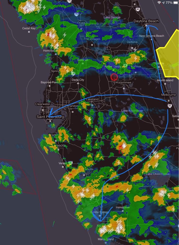
 
That picture actually looks like today in Florida. Flow is easterly. Moisture off the atlantic is getting warmed as it moves over the land. Some convective activity over the ocean, but it really turns on going over the land, that's why all the lightning on the west coast. The Daytona trip should be fine, might have to dodge something coming off the water, but doable below cloudbase. St Pete might be OK if there are bailout options on the way (Lakeland). Issue going west is something could build behind you and if something popped on the way in front, you could get boxed in. Earlier in the AM there would have been a couple very isolated and large storms that would have been fairly easy to dodge.

Correct, storms moving to the west. I don’t know how to capture entire sequence of images, but this is Florida, so storms can popup in minutes.
 
I think his is an area where flight instruction falls short. In my limited experience most CFII's don't get students or newly rated IFR pilots up in "real weather". I trained in Virginia, and I was fortunate. I had more actual time with my CFII by the time my checkride rolled around than most folks I know, but it wasn't stormy weather. I remember one night flight with turbulence so severe it was impossible to read the chart and very hard to read the instruments, but none of it was real world threading through stuff like we have down here in summertime Florida. Several times years later going for BFR checks..and a couple times as rusty pilot refreshers I tried to find instructors that would work with me on that kind of stuff but never had any real luck. Most seem to be very conservative and many are just so new themselves they need the same thing!
 
Depends, there is widely scattered and then just scattered:

Question for all, given this weather radar, and assuming you don’t have onboard active radar, would you fly from Melbourne to
A. Daytona
B. St. petersburg
C. Naples
D. None of the above

For me is would only be A.
B looks doable but storms can fire up in Florida closing the gap.

Animated NEXRAD is the key in Florida. Every day in the summer, storms form over the center of the state from the onshore breeze. Then they all drift towards one coast or the other, depending on which way the high altitude winds are moving. Today everything is moving southeast to northwest. Tomorrow it could be west to east.

If the cells in your screenshot are moving west, then the Daytona run would be fine. If they are moving east, you could get pushed out over the ocean and have zero good options.

St Pete is probably fine either way, because there are dozens of landing options along that route, probably an airfield every 5 miles. Things look ugly ahead, just land. Rare to be more than 5-10 miles from an airfield in Florida, except over the everglades, or the Okefenokee in South Georgia.

I4 corridor.PNG
 
Last edited:
Understood about pop-up vs frontal, but asking as a new pilot myself, can you explain the benefits to riding below the cloud base versus being above it in this situation? This question is assuming it's a scattered layer and I prefer to get above it for comfort reasons (both ride and temperature).

If you are just cruising along in scattered cumulus with the possibility of some towering systems developing, going over the top is fine.

In places like Florida in the summer, where there are widespread rapidly developing cells and you are weaving your way through, staying just under the cloud bases provides 2 advantages.

1. You can easily see the rain shafts contrasted against the ground.
2. You don't have to worry about getting caught on top.
 
Last edited:
Had to use the "go under and dodge the rain shafts" trick this afternoon. This crap all popped up about 60 miles from our destination. I was up at 10k, but would've been imc and no way I could've dodged the cells. Dropped down below the bases and it was easy. It was about 2500agl and I was still ifr. "Deviation as necessary approved". Thankfully we're in northern Minnesota so the heat wasn't unbearable.
20210629_115510.jpg
 
It sounds like you have been lucky and from that have concluded that you are a thunderstorm genius. Remember that the goal for inexperienced pilots is to fill the bag of good judgment before the bag of luck is empty.
The key to good judgement is experience. And the key to experience is bad judgement.
 
Depends, there is widely scattered and then just scattered:

Question for all, given this weather radar, and assuming you don’t have onboard active radar, would you fly from Melbourne to
A. Daytona
B. St. petersburg
C. Naples
D. None of the above

For me is would only be A.
B looks doable but storms can fire up in Florida closing the gap.

af991e32bf2e55b9faed645592305b18.jpg
Honestly, I don’t see two points that I could not connect. Everything will be a bit different by the time you get there. Take some extra petrol. Take the long way.

Again, I’m not encouraging anyone to do something silly or beyond their comfort level.
 
Depends, there is widely scattered and then just scattered:

Question for all, given this weather radar, and assuming you don’t have onboard active radar, would you fly from Melbourne to
A. Daytona
B. St. petersburg
C. Naples
D. None of the above

For me is would only be A.
B looks doable but storms can fire up in Florida closing the gap.

af991e32bf2e55b9faed645592305b18.jpg
That looks like widespread to me, not scattered.
 
Personally, a forecast of scattered thunderstorms makes me a bit nervous when flying IFR in IMC — whether I accept that or not will depend on other factors in the flight. A forecast of isolated embedded on an IMC day is within my comfort zone (assuming my Stormscope and SiriusXM are both working), but I'll still try to get between layers. If it's day time and I can stay VFR, then scattered is fine, and even widespread (in certain situations) might be OK for a short hop, but of course, I wouldn't try to thread a gap in a squall line under any circumstances.

I think there are too many variables for you to proclaim a hard-and-fast rule like you're trying to do. My aircraft, for example, is all-metal and lightning safe (as are composites with a metal web embedded). If I were flying a VFR-only composite like a Diamond Katana, which could could delaminate in a lightning strike, I might avoid areas with even scattered TS in the forecast. Likewise if I were flying a very slow plane which couldn't move much faster than the cells.

A lot of it also depends on experience. I have 1,200 hours, a lot of it in weather, so I'm moderately confident in my ability to interpret what's happening from a variety of cues (radar imagery and Stormscope, of course, but also shifts in wind direction, changes in altimeter settings, changes in temperature at altitude, the temperature gradient while climbing, etc). A 200-hour pilot might not have all of those tools yet, and could easily fly themselves into a corner without realising it, so sticking to forecasts of isolated or better isn't necessarily a bad learning strategy for the first few hundred hours.
Yet again you are saying something that I did not. No hard and fast rule here.
Yes, we have on board radar, and that is great in many situations. During the day with scattered airmass storms, usually visual out the windscreen is better.
I don’t look at all those weather cues. It’s not going to make a difference in our type of operation.
 
Honestly, I don’t see two points that I could not connect. Everything will be a bit different by the time you get there. Take some extra petrol. Take the long way.

Again, I’m not encouraging anyone to do something silly or beyond their comfort level.
Unfortunately, I'm one of those fools who had to actually fly into a new, developing cell to learn respect — that's when it stopped being an abstract, connect-the-dots challenge for me.

I'm hoping that unlike me, most of the rest of you are smart enough to learn why you shouldn't stick your hand into the fire without having to burn it first. That doesn't mean don't fly at all when there are scattered TS, but treat the pagan storm gods with reverence, and never try to thread a small gap (they don't like to be crowded).
 
Unfortunately, I'm one of those fools who had to actually fly into a new, developing cell to learn respect — that's when it stopped being an abstract, connect-the-dots challenge for me.

I'm hoping most of the rest of you are smart enough to learn not to stick your hand into the fire without having to burn it first, like I did. That doesn't mean don't fly at all when there are scattered TS, but treat the pagan storm gods with reverence, and never try to thread a small gap (they don't like to be crowded).
Sheesh… no, I’ve never threaded a gap in 20,000+ hours of flying as airline Capt.
 
Sheesh… no, I’ve never threaded a gap in 20,000+ hours of flying as airline Capt.
I might have been misreading the radar imagery the OP shared, or misremembering the width of Florida, but I didn't see any 40+ nm gaps for option C in that imagery, and option B was, at best, borderline.

Different, maybe, for an airline pilot with turbines, but for those of us in slow piston planes, we can't usually get above the other weather to see just the cells poking up, and we're not fast enough to get through smaller gaps before they close up.
Yup. The book says 40nm. Stick to that book minimum and you will never get anywhere.

Again, not suggesting anyone do anything silly or beyond their comfort level.
 
I might have been misreading the radar imagery the OP shared, or misremembering the width of Florida, but I didn't see any 40+ nm gaps for option C in that imagery, and option B was, at best, borderline.

Different, maybe, for an airline pilot with turbines, but for those of us in slow piston planes, we can't usually get above the other weather to see just the cells poking up, and we're not fast enough to get through smaller gaps before they close up.

Having lived in both FL and the Northeast. You can't compare convective activity over FL vs the NE (and adjoining Canadian regions). I was able to look at both radar and out my window just north of Daytona most of the day yesterday. I would have comfortably flown along the east coast all day. Seabreeze was suppressing most of the convective activity, but at the same time feeding moisture and instability to the central and west coast that was getting heated and turning into T-storms. Nothing was moving particularly fast, and many of the storms were dissipating in fairly short time. A radar picture like that in New England, (or the Southwest) I never would think of taking off.
A typical southern "pop-up" with a rain shaft that lets you see whether or not there is an associated gust front, I'm very comfortable being much closer than 40nm.
Just to clarify, the guideline is 20 nm from the nearest cell; 40 nm if you want to pass between two cells (20 nm from each).

The rain shafts appear mainly when the cell reaches the mature/dissipating stage (with the gust front you mention), so those won't tell you if you're about to fly under or into a developing cell, as happened in my case. Sferics like a Stormscope or Strikefinder will give you much earlier warning, because there will usually be lightning activity within a cell well before any rain or lightning is visible outside it.

Acknowledged that storms can be more predictable among coastlines. In southern/eastern Ontario, you'll often get a storm-free corridor over the cooler water just offshore in Lake Ontario in the summer during the day, for example (but not always). There is an onshore lake breeze very similar to a sea breeze.
 
Last edited:
These two statements are hard to reconcile, at least when it comes to flying light piston aircraft.
I’m not exactly sure what you are saying here, but perhaps my first statement you quoted had a bit of sarcasm in it.
 
Just to clarify, the guideline is 20 nm from the nearest cell; 40 nm if you want to pass between two cells (20 nm from each).

The rain shafts appear mainly when the cell reaches the mature/dissipating stage (with the gust front you mention), so those won't tell you if you're about to fly under or into a developing cell, as happened in my case. Sferics like a Stormscope or Strikefinder will give you much earlier warning, because there will usually be lightning activity within a cell well before any rain or lightning is visible outside it.
The point on pop-ups and gust fronts is that some of the Florida ones have no gust front. You can tell by looking at where the rain meets the ground. When the rain looks like it's just going straight into the ground, no gust front. On the other hand if it's slanted and it looks like the rain is "churning" near the ground - gust front and that can propagate pretty far out from the cloud. You can pass pretty darn close to the "no gust front" rain shafts. They are typical on a day like yesterday with widespread build up. There were also some stay well away storms as well in the mid-afternoon and more in the middle and west coast of FL.
 
I was able to look at both radar and out my window just north of Daytona most of the day yesterday. I would have comfortably flown along the east coast all day. Seabreeze was suppressing most of the convective activity, but at the same time feeding moisture and instability to the central and west coast that was getting heated and turning into T-storms.

We got hammered on the west coast. Here is the view out my window in Tampa yesterday at 5pm. Cells drifted slowly NW; if you flew offshore along the west coast you could get trapped pretty easy.

PXL_20210629_210124039.jpg PXL_20210629_210400992.jpg

Key point here is knowing direction cells are moving. Backside is generally smoother. Last week I was within 2 miles of a very heavy rain shaft without issue. Zero feet visibility inside, according to my buddy on the airfield I was trying to get to.
 
The point on pop-ups and gust fronts is that some of the Florida ones have no gust front. You can tell by looking at where the rain meets the ground. When the rain looks like it's just going straight into the ground, no gust front. On the other hand if it's slanted and it looks like the rain is "churning" near the ground - gust front and that can propagate pretty far out from the cloud. You can pass pretty darn close to the "no gust front" rain shafts. They are typical on a day like yesterday with widespread build up. There were also some stay well away storms as well in the mid-afternoon and more in the middle and west coast of FL.
Agreed that every cell is different, but no gust front now doesn't necessarily mean no gust front 5–10 minutes from now, if the cell ticks over into the dissipating stage during that time.
Three+Stages+of+a+Thunderstorm.PNG
 
Here's a fun Florida pop-up storm from 3 weeks ago. I took off from FD77, flew 8 miles to VPDUT to practice acro, did a few maneuvers, then turned around to go home. I had been aloft for 12 minutes. I could not see my home airfield because of a wall of rain. Zero visibility beyond the edge of the precip. Everything appeared to be moving NW, so I spent about 45 minutes loitering and probing the backside before finally giving up and landing at KCHN to wait it out. I had never been that close to a rain shaft that heavy, probably 1-2 miles at a few points, and it was a little bumpy but nothing overly alarming. I was in a Decathlon so my wings are pretty stout.

flight.PNG
 
Agreed that every cell is different, but no gust front now doesn't necessarily mean no gust front 5–10 minutes from now, if the cell ticks over into the dissipating stage during that time.
View attachment 97835
Think one thing that might be missing is that the radar picture with the "can I go to these three places?" had a lot of yellow and tiny red that was a convective cell, but not a thunderstorm. They were likely topping out at 20 - 30k. These can dump a good bit of rain thanks to our adjacent, warm ocean pumping moisture, but they don't tower up like a CuNim can. The ones from that day on the west coast were as they had heat from going across the peninsula. You'll see that better in the morning where there is less build up but a few true towering CuNims that had enough energy to get through the night. As the day heats up, you get tons of smaller cells that never put out lightning, but crank out rain. Those typically don't produce gusts as they just don't have the stored energy of a 40 to 60k tall cloud.
 
Think one thing that might be missing is that the radar picture with the "can I go to these three places?" had a lot of yellow and tiny red that was a convective cell, but not a thunderstorm. They were likely topping out at 20 - 30k. These can dump a good bit of rain thanks to our adjacent, warm ocean pumping moisture, but they don't tower up like a CuNim can. The ones from that day on the west coast were as they had heat from going across the peninsula. You'll see that better in the morning where there is less build up but a few true towering CuNims that had enough energy to get through the night. As the day heats up, you get tons of smaller cells that never put out lightning, but crank out rain. Those typically don't produce gusts as they just don't have the stored energy of a 40 to 60k tall cloud.
Did you notice the lightning strikes? Better than looking for colors.
 
Back
Top