Instrument Approach's and Departures - Abnormal things to teach?

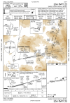
The dashed missed approach track line starts JIRDI on the Profile View, but not until the runway on the Plan View. I wonder if the guy building the approach had the runway on his mind when he did the Missed Approach Procedure.
The missed approach ground track on the charts is pretty notional, not to be taken as anything approximately "to scale". The charting office people take the form 8260-3 or -5 and use that to draw the lines. That form will clearly indicate the MAP as being JIRDI. And the initial portion of the missed approach is indeed straight ahead, for a climb from 1320 to 1600, 280 feet, which will take at most 280/200 = 1.4 nm. So that turn should be taking place pretty much right over the runway threshold if not before. But again, the plan view of the missed approach is only really valid in concept, not as an actual line to follow.
 
Some of my best remembered scenarios were circling approaches below a ridgeline, and approaches not aligned with runway, to an island airport that involves some distance over water and then rising terrain (through a sound) on either side of the approach course. Also, filing IFR to one airport, then cancelling under an overcast to land VFR at an un-served airport.
 
Here's my fave local approach which is a "TEST" of the student's ability to chair fly and anticipate. Note the challengingly close location of the VOR to the MAP. DO not cross at 2300; cross at 1800, whence you have two miles (1:20) to get down to 1140. Get it good and slow. This one is really sweet partial panel as the "no guidance leg" is less than 2 minutes.

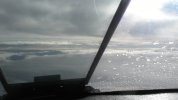
Then there's Bozeman.....yes that's clear ice from a cumulus protruding into the hold; and believe it or not there was a guy holding at 14,000 below me (I'm at 16). One in, one out, it's a box canyon.
 

Attachments

Last edited:
That's true, but that's also a great discussion scenario. "You descend below the MDA and are on short final when another airplane pulls out on the runway. You have to go missed. What do you do?"

On many, many approaches this is no big deal and isn't something we really need to consider. But on this one and others like it, it takes some real thought.
I kinda like the LDA 25 into KEGE:

Screenshot 2026-07-29 at 11.11.54 PM.png
There's a few "what ifs" here. Everything is relatively normal prior to the FAF except for the obvious that it's an LDA despite being lined up with the runway. An LDA/GS to boot. Once you're inside the FAF, though, there's really three segments.

The first is fairly normal: You're inside the FAF and above minimums. If you break out above minimums, you land.

The second starts at minimums: You're going to be about 4.5nm from the airport. You may be out of the clouds and have ground contact, you're in the Fly Visual segment but you don't necessarily have the field in sight for another mile and a half, you can truck along at minimums for a bit but you're making your glidepath ever higher. It's this way because the Snow VOR is on top of a big mountain at an elevation of 8,070 feet, even though it isn't really obvious from the plate. If you've ever lined up on runway 25 at KEGE, it looks quite intimidating. The minimums are where they are because of the climb gradient necessary to reach a safe altitude by SXW.

Finally, there's the third segment, which starts when you descend below minimums. If for some reason you had to go around after that, well, you'd best be aware of the departure procedure because you'll need it to avoid going splat. Turn left to 206º no later than the departure end of the runway, minimum climb gradient of 740 feet per nautical mile.

It's a fun airport to go to in real life, like many others in that area. Much more fun when VMC, though...
 
I kinda like the LDA 25 into KEGE:

View attachment 153859
There's a few "what ifs" here. Everything is relatively normal prior to the FAF except for the obvious that it's an LDA despite being lined up with the runway. An LDA/GS to boot. Once you're inside the FAF, though, there's really three segments.

The first is fairly normal: You're inside the FAF and above minimums. If you break out above minimums, you land.

The second starts at minimums: You're going to be about 4.5nm from the airport. You may be out of the clouds and have ground contact, you're in the Fly Visual segment but you don't necessarily have the field in sight for another mile and a half, you can truck along at minimums for a bit but you're making your glidepath ever higher. It's this way because the Snow VOR is on top of a big mountain at an elevation of 8,070 feet, even though it isn't really obvious from the plate. If you've ever lined up on runway 25 at KEGE, it looks quite intimidating. The minimums are where they are because of the climb gradient necessary to reach a safe altitude by SXW.

Finally, there's the third segment, which starts when you descend below minimums. If for some reason you had to go around after that, well, you'd best be aware of the departure procedure because you'll need it to avoid going splat. Turn left to 206º no later than the departure end of the runway, minimum climb gradient of 740 feet per nautical mile.

It's a fun airport to go to in real life, like many others in that area. Much more fun when VMC, though...
@Arizonaflightlabs there are other Fly Visual Approaches out there, can’t think of any off the top of my head. Anybody ??

If you used the BEVVR ONE DEPARTURE for what you’d do if you had to miss after the Missed Approach Point for the LDA Rwy 25 Approach, then yeah 206 would be the heading, but the BEVVR ONE is an RNAV Dearture. If you had RNAV, you’d probably be doing an RNAV 25 Approach. If doing the LDA Rwy 25 Approach you’d probably be looking to the GYPSUM SIX or MEEKER FOUR Departure for guidance on what to do if you had to miss late. Those start out with 219 headings.
 
Last edited:
@Arizonaflightlabs

If you used the BEVVR ONE DEPARTURE for what you’d do if you had to miss after the Missed Approach Point for the LDA Rwy 25 Approach, then yeah 206 would be the heading, but the BEVVR ONE is an RNAV Dearture. If you had RNAV, you’d probably be doing an RNAV 25 Approach. If doing the LDA Rwy 25 Approach you’d probably be looking to the GYPSUM SIX or MEEKER FOUR Departure for guidance on what to do if you had to miss late. Those start out with 219 headings.
ATC generally still assigns the LDA 25 to everyone going in there. You could ask for the RNAV Y, sure... But I've never heard anyone actually do that.

I am kinda surprised at the difference in climb gradients, though. Maybe @RussR can educate us as to how you can get nearly 1000 feet lower on the RNAV. With a required climb gradient, sure, but a downright reasonable one compared to the required gradients on the departures.

However... Looking at the RNAV Y 25, you still have the situation where you can be visual at minimums and see the ground but not the airport right away. It's just gonna happen much faster than the LDA.
The speed limit on the RNAV Y missed probably has something to do with it. That will increase the Angle of Climb and reduce the Radius of Turn. The LDA doesn’t have a speed limit. Interesting thing about the LDA missed is it says”…climb direct SKW VOR/DME, cross SKW VOR/DME, then…” I don’t think I’ve ever seen that ‘cross, then’ thing before. They’re taking no chances that you are following along with RNAV and treat it as a Fly-by, not a Fly-over
 
I don’t think I’ve ever seen that ‘cross, then’ thing before. They’re taking no chances that you are following along with RNAV and treat it as a Fly-by, not a Fly-over
I suspect you are exactly right. It's to remind pilots not to use turn anticipation, since the protected area for a VOR turn is based on crossing the navaid. We did a Pilot Workshops scenario involving a flight to KAJO to KHHR via the ONPT3 (which I see has been redesignated the ONTQ3) and the need to cross PDZ before making the turn instead of 3 NM before reaching it.

(The scenario involved a Garmin GPS which prompted an early turn; interestingly, an Avidyne would not have anticipated the turn, but that wasn't discussed)

Hmmm. I guess a routing like that goes into this thread nicely.
 
I suspect that the verbiage was there before “following along with RNAV” was a thing. ;)
Most likely. There are plenty of "cross ... then" directives in TERPS and other procedure design document. Turn anticipation at VOR and VOR intersections, especially enroute, existed before RNAV.
 
Most likely. There are plenty of "cross ... then" directives in TERPS and other procedure design document. Turn anticipation at VOR and VOR intersections, especially enroute, existed before RNAV.
Have you seen an Approach Chart that has that language
 
Most likely. There are plenty of "cross ... then" directives in TERPS and other procedure design document. Turn anticipation at VOR and VOR intersections, especially enroute, existed before RNAV.
Yeah. And in the AIM. 5-3-5 So yeah, it’s about more than using RNAV.

5−3−5. Airway or Route Course Changes
a. Pilots of aircraft are required to adhere to airways or routes being flown. Special attention must be given
to this requirement during course changes. Each course change consists of variables that make the technique
applicable in each case a matter only the pilot can resolve. Some variables which must be considered are turn
radius, wind effect, airspeed, degree of turn, and cockpit instrumentation. An early turn, as illustrated below, is
one method of adhering to airways or routes. The use of any available cockpit instrumentation, such as Distance
Measuring Equipment, may be used by the pilot to lead the turn when making course changes. This is consistent
with the intent of 14 CFR section 91.181, which requires pilots to operate along the centerline of an airway and
along the direct course between navigational aids or fixes.
b. Turns which begin at or after fix passage may exceed airway or route boundaries. FIG 5−3−1 contains an
example flight track depicting this, together with an example of an early turn.
c. Without such actions as leading a turn, aircraft operating in excess of 290 knots true air speed (TAS) can
exceed the normal airway or route boundaries depending on the amount of course change required, wind
direction and velocity, the character of the turn fix (DME, overhead navigation aid, or intersection), and the
pilot’s technique in making a course change. For example, a flight operating at 17,000 feet MSL with a TAS of
400 knots, a 25 degree bank, and a course change of more than 40 degrees would exceed the width of the airway
or route; i.e., 4 nautical miles each side of centerline. However, in the airspace below 18,000 feet MSL, operations
in excess of 290 knots TAS are not prevalent and the provision of additional IFR separation in all course change
situations for the occasional aircraft making a turn in excess of 290 knots TAS creates an unacceptable waste of
airspace and imposes a penalty upon the preponderance of traffic which operate at low speeds. Consequently,
the FAA expects pilots to lead turns and take other actions they consider necessary during course changes to
adhere as closely as possible to the airways or route being flown.

 
Have you seen an Approach Chart that has that language
If I did, I probably wouldn't have even noticed it as something unusual. After all, climb to X altitude, then turn is very common. Why not when crossing a fix?

I'm pretty good at this search stuff but I have no idea how to do a wildcard word search through every 8260- IAP source document in the FAA Instrument Flight Procedure collection.
 
Last edited:
I am kinda surprised at the difference in climb gradients, though. Maybe @RussR can educate us as to how you can get nearly 1000 feet lower on the RNAV. With a required climb gradient, sure, but a downright reasonable one compared to the required gradients on the departures.

Yeah, these ones are complicated enough that I can't even start to guess without actually breaking out the software and doing an evaluation. RNAV missed approach areas are much smaller than LDA/VOR areas, but with the predominant obstacle straight ahead in either case, it doesn't seem like that would matter.

It could be as simple as when the approaches were first designed, and the criteria in use at the time. While procedures are routinely reviewed for safety, they're not necessarily reviewed for "optimization" unless there's a request for it to be changed/improved.

I have flown this one in both IMC and VMC multiple times, and it is definitely a pretty good one. Also fun are the departure procedures. You're right, that mountain is intimidating (and there's the smaller "hill" just south of the departure end that you kind of weave around).
 
lol. We already know that. Any others?
Like Mark, it’s probably something that wouldn’t show up on my radar unless I saw an approach with it included. But seeing it on the Eagle chart, I know it was there the first time I flew the procedure more than 30 years ago.

And I specifically remember the conversation with my instrument instructor about the info in AIM 5-3-5 that you quoted. (Odd how one remembers specific conversations from 40 years before.)
 
The speed limit on the RNAV Y missed probably has something to do with it. That will increase the Angle of Climb and reduce the Radius of Turn. The LDA doesn’t have a speed limit. Interesting thing about the LDA missed is it says”…climb direct SKW VOR/DME, cross SKW VOR/DME, then…” I don’t think I’ve ever seen that ‘cross, then’ thing before. They’re taking no chances that you are following along with RNAV and treat it as a Fly-by, not a Fly-over

I agree that the "cross SKW then" must be just an attempt to force a fly-over to eliminate early turns. It's about the only way to word it, I'd think.

Speed limits aren't used to allow a steeper climb, climb gradients are already specified in terms of feet per nm anyway. Speed limits really only matter for turning segments, to reduce the distance of turn anticipation. There are two main reasons to do this - 1) reduce the size of the protected area to eliminate problematic obstacles, and 2) reduce the leg length requirements either before or after the fix. In this case, I believe it's probably #2. WAMIB to ZEDPO is "only" 5.5 nm. Standard missed approach design speed is 265 kts, which especially at these altitudes is going to result in some high TAS and huge turn radius. By limiting the missed approach speed, the turn gets tighter and the leg length becomes sufficient.

But that's a guess, I didn't do any math.

Bonus note - if I remember correctly, speed restrictions weren't, or aren't, permitted on ILS/VOR approaches like they are on RNAV. Not for any real practical reason, just that RNAV criteria is much newer and gets more attention, and speed restrictions were included.
 
Back
Top