GTN 650 and a clearance from Santa Monica (KSMO)

PilotRobert

Filing Flight Plan
Joined
Mar 7, 2018
Messages
11
Display Name

Display name:
PilotRobert
Sorry long explanation for a one line question at the bottom.

I have been a private pilot since 1989 and an IFR rated pilot since 2001 and really got the rating more for safety then flying in IFR conditions. Although I do not fly much IFR. Recently I have been trying to get back to some IFR basics and and have completed my IPC. So now I am trying to file IFR every cross country trip more to handle the radio/clearance aspect. So with all that said I recently did an Angel Flight from KBFL to KSMO with minimal effort for the IFR clearance and flight. It was on my return leg where it got more interesting. I will try to layout my accepted filed route and then the clearance I received from Santa Monica ground.
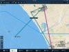
Flight KSMO - KBFL
Route approved: CHATY V23 GMN FASTO2

My clearance went like this (i am not a controller so please forgive my ATC attempted lingo please).

Angel Flight XXX clear to Bakersfield Airport fly runway heading to Los Angeles radial 315 turn right heading 250 vectors to victor 23 gorman vor then as filed maintain 3000 expect 10000 in 5 minutes departure frequency 124.2 squawk 4660.

So being relatively inexperienced in IFR clearances that was a lot to take in to start with but I managed my way through it.

So on to programming the GTN 650. I have to say I am not really all that experienced with the unit but I do my normal good pilot practice using simulators on the GTN 650 and thought I was doing fairly well with it until this happened. I pride myself as being pretty tech savvy as well.

So new Flight Plan. I enter KSMO as the first waypoint/departure point then I am thinking what the heck do I do next. Luckily the plane was not running at this point so I had some time to fiddle. I thought okay enter LAX and see if you can find a way to enter a radial. No luck. So I tried a few more things and it seemed like the more I tried the worse it got. So I settled with this which sucked but got me through.

Programmed the GTN 650 for...
KSMO
CHATY (On the V23 airway)
GMN
FASTO
KBFL

Then programmed the NAV 2 which is an old radio/cdi combination for LAX vor 113.6 set the CDI to 315

Then I flew out of KSMO on runway heading until the needle was centered on the CDI then turned right to a heading of 250 and then was given a vector to intercept the V23 airway then as programmed in the GTN 650.

So my question is how should I have programmed the GTN 650 for this?
 
I agree with @Plano Pilot's observation. There are a couple of ways to do this using OBS mode and perhaps user waypoints, but some things are easier to do old school.

Without looking at the chart, just from your description, I'd have V23 loaded in the GTN, using a waypoint near KSMO as the entry point so there is an airway to join, but have the LA radial for the initial pre-vector turn tuned in.
 
Every time I’ve done it there I have used navs and the heading bug. Just easier that way
 
Believe it or not this actually makes me feel a little better. I thought I was just really over looking a simple setup. When you are working with controllers in and around class bravo airspace you really have to be prepared for what ever they throw at you. So I guess my make due solution was not far off from what others would do. I guess if you fly around areas like this often you get used to it pretty quickly.
 
Gps dependent pilots can get themselves in a bind fairly quick in a place like LA. There is/was a departure out of John Wayne that didn’t even show up on the GTN750 (last time I was there). It was a long one too, all the way up the basin. Finding the happy place between gps and nav to get you where you are going ASAP is important!
 
When told to fly runway heading then that’s what you do. It’s an important point at any airport with parallel runways. There really isn’t a magenta line for it.

OBS mode could be substituted for using a nav receiver but there isn’t any point in doing it that way.
 
Like others said there is an OBS option on the GTN but around LA I use the standard vor nav pretty often, controllers often include one in their clearance or vector you onto one.. I just click the cdi to nav mode from GPS, toss the frequency and radial in and your done

I think you managed very well
 
So I am a bit of a stickler and tinkerer so I set out to figure out ways for the future. I mentioned I am tech savvy it is my day job so I can't help it. I fly with an iPad pro and ForeFlight so I took out the iPad and thought okay how could I get the GPS coordinates to make a waypoint in the GPS. This was probably convoluted and long but this is basically what I did to get a cross on the map to pinpoint the exact location of where the user waypoint should be.

In the ForeFlight app it is KSMO KSMO/212/5 LAX LAX/315/5 to do this on plan.foreflight.com it would be KSMO KSMO212005 LAX LAX315005 (Would work in app too just like the other way better)

So for those that do not fly with ForeFlight that basically creates a route like this.

I use the route lines to pinpoint GPS coords for this example. I created a waypoint in ForeFlight and named it LAX315KSMO212

KSMO
From KSMO draw a line off the 212 (212 because actual runway heading is 212.3) radial from the center of the runway (Only works for this single runway not airports with multiple runways) for 5nm
LAX VOR
LAX VOR draw a line off of the 315 radial from the VOR out 5nm.

KSMO212LAX315.jpg

If picture does not show above due to lack of 5 posts on this forum see attachment below.


From that point I see that the GPS coordinates were approx 33.59.43N 118.28.31W so I could simply add that as a waypoint to the GPS then set up a flight plan. Knowing how to do that now it would take me less than 2 minutes to complete that method and program the GPS then I can set up and use VOR and CDI as backup.

KSMO
NEWWAYPOINT
CHATY
V23
GMN
FASTO
KBFL

I do agree that using the vor cdi is a perfectly acceptable solution and works just fine in this scenario but I thought I would see how else this problem could be solved. I prefer to know as many ways as possible to get to a workable solution.

Thank you all for your comments and suggestions.

The best thing about this is all the great learning that comes from these types of discussions.
 

Attachments

  • KSMO212LAX315.jpg
    KSMO212LAX315.jpg
    209.7 KB · Views: 9
That is all well and good but tell me how you replot your waypoint when there is say a 20knot crosswind? Remember your initial clearance is runway heading not course.:)
 
In addition to the runway course vs. runway heading issue, you can get in trouble basing waypoints off a VOR radial because most VORs are not perfectly aligned with the local magnetic north. They may have been when they were last calibrated but it isn't unusual to see a VOR's declination as much as six degrees off the actual variation. If your method of establishing the fix is using magnetic north instead of the VOR radial your fix will not be where it should be.

The GPS or FMS navigator should take this into account if you enter a radial from a VOR but if you're using other tools you need to make sure that it is using the VOR radial and not the magnetic track from the VOR.
 
That is all well and good but tell me how you replot your waypoint when there is say a 20knot crosswind? Remember your initial clearance is runway heading not course.:)

Very good point. My guess is these things will most likely change in the future. But for now the old ways are probably the best ways.
 
In addition to the runway course vs. runway heading issue, you can get in trouble basing waypoints off a VOR radial because most VORs are not perfectly aligned with the local magnetic north. They may have been when they were last calibrated but it isn't unusual to see a VOR's declination as much as six degrees off the actual variation. If your method of establishing the fix is using magnetic north instead of the VOR radial your fix will not be where it should be.

The GPS or FMS navigator should take this into account if you enter a radial from a VOR but if you're using other tools you need to make sure that it is using the VOR radial and not the magnetic track from the VOR.

I can somewhat get behind what you are saying but the variance would be so small that you would still be well within the acceptable course deviation for ATC at this distance. If you were tracking a radial that was 20+ miles out then sure that course deviation would increase and that might be a real issue.

So for example. 1 degree which is extreme at 100nm would be a course deviation of 2nm and that is still within an airway corridor.

All really good points.

In this example where it is only 2 miles out to LAX 315 from KSMO if a VOR was off via a chart or GPS by a full degree that would be a distance of about 211 feet off course. I would take that over even trying to fly a single degree runway heading which is never gonna happen in almost every GA aircraft. Now for those who will chime in and say well if that happened at LAX where there are parallel runways that it would be a disaster I am gonna come back with so you are saying that compass headings are more accurate then that? That is why there are separation guidelines for ATC. To allow for things like this.

There are definitely things that will need to be improved in the future. More and more technologies are available and it is going to cause more and more confusion in the future. But technology is coming and whether people want to embrace it or not it will not stop it from moving forward and making it even more challenging. With that said I would take a WAAS enabled GPS over a VOR/CDI any day of the week.
 
The VOR's declination can be as much as six degrees. That could produce as much as a 6.0NM error at 60NM from the station.

While the lateral confines of an airway is +/- 4NM from the centerline (within 60NM of the station), that defines the airspace, not the required navigation performance. An IFR airplane is required to fly the centerline of the airway (14 CFR 91.181). For an RNAV equipped flight, RNP for terminal airspace is generally 1.0.

The proper way to fly the clearance that started this thread is to fly the runway heading (not track) until crossing the specified radial. That radial can be determined by tuning the VOR or by generating the radial in the GPS navigator which will account for the VOR's declination. In either case, the radial will be a line, not a point, as the actual crossing point will vary based on wind. If you track to a calculated waypoint you aren't flying the clearance.
 
So I am a bit of a stickler and tinkerer so I set out to figure out ways for the future. I mentioned I am tech savvy it is my day job so I can't help it. I fly with an iPad pro and ForeFlight so I took out the iPad and thought okay how could I get the GPS coordinates to make a waypoint in the GPS. This was probably convoluted and long but this is basically what I did to get a cross on the map to pinpoint the exact location of where the user waypoint should be.
Yep. Two things:
  1. It can be done.
  2. It's convoluted and long; way too much work.

BTW, your scenario is discussed in the context of the 430/530 in this video by Jeff Van West. It's a bit different since, unlike the GTN, those units do not have airways in the database, but the principle is the same.
 
The VOR's declination can be as much as six degrees. That could produce as much as a 6.0NM error at 60NM from the station.

While the lateral confines of an airway is +/- 4NM from the centerline (within 60NM of the station), that defines the airspace, not the required navigation performance. An IFR airplane is required to fly the centerline of the airway (14 CFR 91.181). For an RNAV equipped flight, RNP for terminal airspace is generally 1.0.

I wonder if an accident was attributed to mistakes made due to VOR declination by the NTSB and the FAA was sued how long it would take to get the VOR stations realigned then.
 
I wonder if an accident was attributed to mistakes made due to VOR declination by the NTSB and the FAA was sued how long it would take to get the VOR stations realigned then.
The proper procedures account for any declination in the VOR so I'd guess that the accident would be attributed to the pilot's improper procedures, not the VOR declination, but...

VORs do get realigned. They just don't have to be realigned until they exceed six degrees of declination. Even one that was just realigned will immediately start to develop an declination as the local magnetic variation drifts. Declination error is inherent in the VOR system.
RNAV database vendors account for VOR station declination.
 
RNAV database vendors account for VOR station declination.
I mentioned above that it is accounted for when referencing a radial in an RNAV system. What you quoted was in response to PilotRobert's post. The "proper procedure" that I was talking about is flying a heading when your clearance is to fly a heading.
 
The other downside of doing it in ForeFlight is that if you have a Flightstream and push that ForeFlight VOR route into a GTN, it sends across the lat/long and does NOT tell the GTN you want a VOR radial, unfortunately. It could, if the communications spec allows for that. But I don’t know if it does.

Going the other way is the same, the GTN will drop that as a lat/long waypoint into ForeFlight also, but the GTN in OBS mode would calculate the location correctly. Who knows if ForeFlight does but it’s not certified for IFR... so...

Now I want to go try this with ours. Push both directions and see if the waypoint calculated is the same. I doubt it.
 
I mentioned above that it is accounted for when referencing a radial in an RNAV system. What you quoted was in response to PilotRobert's post. The "proper procedure" that I was talking about is flying a heading when your clearance is to fly a heading.
Not sure why folks don't get your point. Flying a heading has no and cannot have a magenta line. There is no GPS solution to the initial portion of the OPs clearance. You can ask for a track to fly and then program it in the GPS but once the heading clearance is accepted then ya gotta fly the heading. Does it make a difference? It can if you are following someone or someone is following you or if there is a parallel runway.
 
Angel Flight XXX clear to Bakersfield Airport fly runway heading to Los Angeles radial 315 turn right heading 250 vectors to victor 23 gorman vor then as filed maintain 3000 expect 10000 in 5 minutes departure frequency 124.2 squawk 4660.

It's been a good thinking exercise - as a wanna-be IFR student, I want to be able to solve these kinds of twists much more quickly than I do now. I think heading bug and VOR tracking is the answer until you join V23, then switch to the gps and activate the CHATY leg.

Although as I figure out the sequencing, I've hit a question - when you turn right at the 315 radial, aren't you already past v23 (which is the 323 radial). If so, turning to 250 won't bring you back to it.

I'm obviously missing something here
 
Although as I figure out the sequencing, I've hit a question - when you turn right at the 315 radial, aren't you already past v23 (which is the 323 radial). If so, turning to 250 won't bring you back to it.
The clearance leaves you on a 250 heading. The clearance does NOT allow you to join the airway. There will be additional vectors and, eventually, instructions for how to join the route.
 
The clearance leaves you on a 250 heading. The clearance does NOT allow you to join the airway. There will be additional vectors and, eventually, instructions for how to join the route.

Or if they forget about you, you’d ask. Just adding that. You’re still responsible to know where you are and where you’re going...
 
It's been a good thinking exercise - as a wanna-be IFR student, I want to be able to solve these kinds of twists much more quickly than I do now. I think heading bug and VOR tracking is the answer until you join V23, then switch to the gps and activate the CHATY leg.

Although as I figure out the sequencing, I've hit a question - when you turn right at the 315 radial, aren't you already past v23 (which is the 323 radial). If so, turning to 250 won't bring you back to it.

I'm obviously missing something here
The only thing you may be missing is bit of the bigger picture. The initial part of the clearance is to fly out of the way of the little bit of SOCAL traffic created by LAX, VNY, BUR, and a few other quiet airports ;) before turning you back to the north/northeast to join the route.
 
You might have created a user waypoint in the 650 corresponding to the expected intercept on V23, but since you were being vectored, it would have been difficult to anticipate and easier (and it did work) just to use the VOR as you did. Good Job.
 
I would probably do a variation of PilotRobert's theme on ForeFlight. I would enter a ForeFlight route of KSMO KSMO/212/LAX/315 LAX V23 GMN ... The point defined by the syntax KSMO/212/LAX/315 wold depict a route from KSMO to the extended runway track where it intercepts the LAX 315 degree radial, essentially straight out to the shore line and then turn. This is just visual reference, because whenever you cross the LAX 315 degree radial, you are going to turn from runway heading to 250 for vectors. The 315 degree radial reference is on ForeFlight, but you would want to use a panel mount navigation system to determine crossing the radial. I would send the route to my panel from ForeFlight using my FS210 and have the route displayed on my GN530W for IFR guidance. The first two legs are headings and don't require navigation other than determining the 315 radial as the point to change headings. I would let the GPS do its thing until I was given a vector to intercept V23, then I would activate the appropriate leg of V23 and fly the assigned heading until intercepting the airway. The FS210 would convert the reference turn point to the 250 heading to a latitude longitude and a user waypoint at that location in the GNS530W. Once I was on the vector to intercept, it would be child's play to tap my ForeFlight map in the vicinity of the V23 route I was heading towards and it would offer Fly leg as an option, which is what i would use. I could then send that to my GNS530W to provide navigation, if I did not want to do the fly leg from the GNS.
 
I would probably do a variation of PilotRobert's theme on ForeFlight. I would enter a ForeFlight route of KSMO KSMO/212/LAX/315 LAX V23 GMN ... The point defined by the syntax KSMO/212/LAX/315 wold depict a route from KSMO to the extended runway track where it intercepts the LAX 315 degree radial, essentially straight out to the shore line and then turn. This is just visual reference, because whenever you cross the LAX 315 degree radial, you are going to turn from runway heading to 250 for vectors. The 315 degree radial reference is on ForeFlight, but you would want to use a panel mount navigation system to determine crossing the radial. I would send the route to my panel from ForeFlight using my FS210 and have the route displayed on my GN530W for IFR guidance. The first two legs are headings and don't require navigation other than determining the 315 radial as the point to change headings. I would let the GPS do its thing until I was given a vector to intercept V23, then I would activate the appropriate leg of V23 and fly the assigned heading until intercepting the airway. The FS210 would convert the reference turn point to the 250 heading to a latitude longitude and a user waypoint at that location in the GNS530W. Once I was on the vector to intercept, it would be child's play to tap my ForeFlight map in the vicinity of the V23 route I was heading towards and it would offer Fly leg as an option, which is what i would use. I could then send that to my GNS530W to provide navigation, if I did not want to do the fly leg from the GNS.

John I learn something new everyday! I had no idea that the KSMO/212/LAX/315 would work. That is totally awesome. Even if you could not enter that via Connext or some other transfer you could at least get the GPS coords out of ForeFlight to put in to the panel mounted GPS. I know for at least Garmin you need to change in your ForeFlight settings the way GPS coords are displayed if you want to manually enter the coords in to the panel mount unit of convert them. Thank you for this tip!
 
John I learn something new everyday! I had no idea that the KSMO/212/LAX/315 would work.
I guess folks don't read the location box in FF ;)

It's a very handy feature. You can even set up one of those text ODP that tell you to head in a certain direction before proceeding enroute. The original feature did only VORs, but was updated within days to allow course and distance from any waypoint.
 
The other downside of doing it in ForeFlight is that if you have a Flightstream and push that ForeFlight VOR route into a GTN, it sends across the lat/long and does NOT tell the GTN you want a VOR radial, unfortunately. It could, if the communications spec allows for that. But I don’t know if it does.

Going the other way is the same, the GTN will drop that as a lat/long waypoint into ForeFlight also, but the GTN in OBS mode would calculate the location correctly. Who knows if ForeFlight does but it’s not certified for IFR... so...

Now I want to go try this with ours. Push both directions and see if the waypoint calculated is the same. I doubt it.
Let us know if you do it. Give this particular instruction is to fly runway heading until crossing a radial and then head in another direction, and the fairly large tolerance VOR receivers have to begin with, I'd guess any discrepancy would be insignificant from an ATC standpoint.
 
I guess folks don't read the location box in FF ;)

It's a very handy feature. You can even set up one of those text ODP that tell you to head in a certain direction before proceeding enroute. The original feature did only VORs, but was updated within days to allow course and distance from any waypoint.

I actually do read the location box in FF. I have never seen a way to do the KSMO/212/LAX/315 I was under the impression that LAX/315/30 was the only way. But I am glad I now know this way works too.

Can you elaborate on the text ODP? I have not ran across that one yet either. I love learning more and more about FF everyday. Insanely awesome application for sure.

Let us know if you do it. Give this particular instruction is to fly runway heading until crossing a radial and then head in another direction, and the fairly large tolerance VOR receivers have to begin with, I'd guess any discrepancy would be insignificant from an ATC standpoint.

I agree with your statement. Others here disagree but then again they are not PIC in your plane so. IMHO it should be changed to this new method in the future anyway. Why let wind, magnetic changes and etc. have planes flying with these variances everyday when simple GPS coords would keep things much more consistent with MUCH better separation. Most here agree but say that it is not how it is now. So for now I will try it as long as it is not a 30kts wind day at 1000ft AGL where it might make a slight difference in that very short distance between KSMO and LAX/315.
 
Let us know if you do it. Give this particular instruction is to fly runway heading until crossing a radial and then head in another direction, and the fairly large tolerance VOR receivers have to begin with, I'd guess any discrepancy would be insignificant from an ATC standpoint.

I’ll try to do it “soonish”. Back to normal day job for the moment upping the cash flow after the CFI stuff. :) And the poor airplane has forgotten that it can go places other than the pattern at KAPA and the practice areas. I really need a long XC after all of that start, stop, start, stop, start, stop CFI prep. Also quite sick of power off 180s right now. Ha.

Anyway as soon as I can take it out somewhere far enough from a VOR to do some playing around I’ll report back. Hopefully with screen and panel shots. It’s an interesting question about how the radial notation in ForeFlight will translate over to the GTN, if at all.

@flyingcheesehead may also be able to do a test in his Mooney before I get around to it.
 
I'd load KSMO LAX V23 etc. Then I'd fly straight ahead for about a minute and then turn to heading 250, get vectored, then wait for them say join V23 which will be real easy because it is already there in all it's magenta glory. That clearance is about not going straight ahead to long and picking off departures off of KLAX and not turning North to soon and picking off BUR/VNY traffic. Being precisely at the 315 radial is not needed. That clearance hasn't changed since before GPS was invented. The distance between 311 and 319 radials(+/- 4 degrees) there is about .65 miles, little over half a mile. The distances from the runway are between about 1 and 1.6 miles. Plug in your climb speed to fine tune the above mentioned "about a minute."
 
Last edited:
I'd load KSMO LAX V23 etc. Then I'd fly straight ahead for about a minute and then turn to 250, get vectored, then wait for them say join V23 which will be real easy because it is already there in all it's magenta glory. That clearance is about not going straight ahead to long and picking off departures off of KLAX and not turning North to soon and picking off BUR/VNY traffic. Being precisely at the 315 radial is not needed. That clearance hasn't changed since before GPS was invented. The distance between 311 and 319 radials(+/- 4 degrees) there is about .65 miles, little over half a mile. The distances from the runway are between about 1 and 1.6 miles. Plug in your climb speed to fine tune the above mentioned "about a minute."
I'd still put the radial in the VOR despite the obvious small distance. Why? (1) that was the clearance; (2) we get so little practice using our VORs these days, might as well take advantage of it.
 
I'd still put the radial in the VOR despite the obvious small distance. Why? (1) that was the clearance; (2) we get so little practice using our VORs these days, might as well take advantage of it.
Yeah. I would to. Just bringing up another perspective
 
If ATC tells you to fly a HEADING then fly a HEADING. ATC is already compensating for the wind. Flying a TRACK instead of a HEADING can put you somewhere that ATC is not expecting. This is spelled out in the AIM.
 
The issue with SMO is that the departure is meant to mimic part of the VFR noise abatement departure - the part where you make no turns till the shoreline. The LAX315 radial happens to basically coincide with the shoreline. The turn then has you climbing away from LAX departure traffic till you are high enough to turn back and fly back over LAX, where they usually want you at 5000 feet. They should just make a GPS waypoint there to simplify /G clearances, but who knows why they don't.
 
Back
Top