MauleSkinner
Touchdown! Greaser!
Yes…it’s called “GPS.”Has anyone done some sort of celestial navigation computer?
")
Yes…it’s called “GPS.”Has anyone done some sort of celestial navigation computer?
Has anyone done some sort of celestial navigation computer? I've always thought that would be an amusing use of a raspberry pi, but never researched it deeply enough.
Obviously no good in IMC or with high overcast
Yeah but the good ole days of interference free JDAMs hitting their targets, seems to be over. Then again, even reverting to INS only, a typical MK-84 will still have an acceptable kill radius. One things for certain though, I wouldn’t want to be flying over there.I doubt truck drivers are using SAASM M-Code receivers, unless they’re military trucks. Classified technology to circumvent spoofing.

 www.rusi.org
I think more accurate to say:Not all VORs are being taken off line— they are going to maintain the Minimum Operating Network (MON) that will insure a ground based nav capability for the foreseeable future.
Except to receive MON stations at the 100 nm service volume the aircraft assumes the aircraft above 5000 ft AGL and a weather hazard called ice in the northern states starting about mid October.There’s the MON plus ILS/LOCs. It will be a bit before it’s all taken offline. Not perfect but still a viable IFR environment. So my recommendation still stands.
Didn't say it was perfect and what you state still doesn't change my position or recommendation to maintain a VOR/ILS/LOC capability in the panel. If they come up with a better mouse trap at some point and we can ditch VOR completely I'm all for it, but until then........Except to receive MON stations at the 100 nm service volume the aircraft assumes the aircraft above 5000 ft AGL and a weather hazard called ice in the northern states starting about mid October.
That's actually how business jets and airliners used to navigate before GPS - by using two DME stations (DME/DME NAV). That was not that long ago, and it still exists as a backup in pretty much every FMS today. Works great for enroute and terminal, not so much for approaches or oceanic, of course. It's nowhere near as accurate as GPS/GNSS.why not change the A to P for a Ground Based Positioning System? GPS minus the satellites, but otherwise the same thing.
How else could you listen to the NFL games?Sure glad I saved my ADF.
At least it won't take out the magnetos.Just wait 'til the EMP fries your IMU.
Yes, and the capability has been around for a long time. Extremely low duty cycle but very effective.Has anyone done some sort of celestial navigation computer?
Weather isn't really an issue for the system I'm thinking of.Obviously no good in IMC or with high overcast
Depends on how close you are.At least it won't take out the magnetos.
Our old system tracked 6 DME and 2 VOR stations. I cannot remember how many we needed to get an accurate position, but I think it was more than 2.That's actually how business jets and airliners used to navigate before GPS - by using two DME stations (DME/DME NAV). That was not that long ago, and it still exists as a backup in pretty much every FMS today. Works great for enroute and terminal, not so much for approaches or oceanic, of course. It's nowhere near as accurate as GPS/GNSS.
A lot of people are thinking about how to augment GNSS with an independent system, similar enough to provide the same or better performance but dissimilar enough to not be jammed and spoofed in the same way. Not just for aviation... the whole world has become addicted to GNSS, it seems.
- Martin
From Wikipedia on Cestrial Navigation:
The US Air Force and US Navy continued instructing military aviators on celestial navigation use until 1997.
Our old system tracked 6 DME and 2 VOR stations. I cannot remember how many we needed to get an accurate position, but I think it was more than 2.
That's mathematically correct.DME/DME systems need 3 to give a specific positon. Two stations give you 2 possible positions.
Are they spoofing GLONASS, too? Are both being spoofed simultaneously, and with matching spoofs? Might make sense to have both GLONASS and GPS receivers.
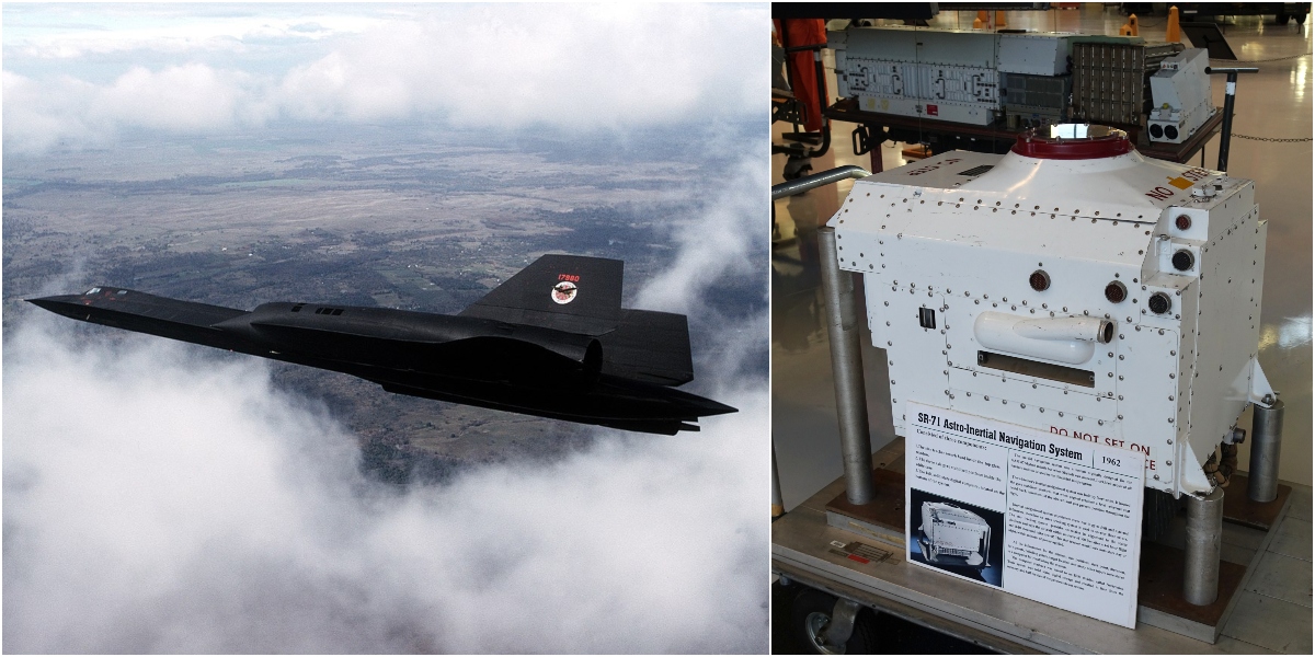
I am pretty sure that was designed and flown in the 60’s for a certain famous high flying spy plane.Has anyone done some sort of celestial navigation computer? I've always thought that would be an amusing use of a raspberry pi, but never researched it deeply enough.
Obviously no good in IMC or with high overcast
 theaviationgeekclub.com
What you're describing is basically a "life-hacked" LORAN based off short-range pre-existing civilian infrastructure instead of "long" wave .mil controlled surplus naval transmitters. I like it. Make VHF Nav great again.I'll toss out a software challenge... It should be possible to do this based on FM radio stations. They're all over the place, their location is known, they're VHF, and they're powerful. Four little antennas and some simple hardware can give you a DF fix within a few degrees of all the local stations. From there I bet it's possible to discern a location, especially if you start tracking from a known starting point.

Yeap, until there is a problem, there will not be a solution.'The problem is GPS market capture. Until GPS reliance starts showing actionable cracks in safety traffic flow, there won't be an economic incentive for the market to re-attack any ground nav FMS offering for sub-6k piston land. Things like the KNS80 and LORAN existed for a reason, and it was GPS which primarily killed them. But like every initial adoption of single point of failure solutions, opportunity costs are/were always viewed as "that's my grandkids' problem not mine". tEe-EHsS-oHH potato makes the entry to market more sclerotic than it has to be, but that's a Tuesday in this space and not worth rehashing, everybody on here already knows that memo.
What you're describing is basically a "life-hacked" LORAN based off short-range pre-existing civilian infrastructure instead of "long" wave .mil controlled surplus naval transmitters. I like it. Make VHF Nav great again.
I think there's some fundamental technical differences: Loran had precision clock time info in what was transmitted (kinda sorta like what the GPS satellites do now) - but FM broadcast transmitters have nothing like that in what they put out. Without that timing info in the signals, using FM broadcast to navigate would have to work more like an ADF of some sort, as a VHF direction finder. Could be automated, probably, given today's electronic and software capabilities.The problem is GPS market capture. Until GPS reliance starts showing actionable cracks in safety traffic flow, there won't be an economic incentive for the market to re-attack any ground nav FMS offering for sub-6k piston land. Things like the KNS80 and LORAN existed for a reason, and it was GPS which primarily killed them. But like every initial adoption of single point of failure solutions, opportunity costs are/were always viewed as "that's my grandkids' problem not mine". tEe-EHsS-oHH potato makes the entry to market more sclerotic than it has to be, but that's a Tuesday in this space and not worth rehashing, everybody on here already knows that memo.
What you're describing is basically a "life-hacked" LORAN based off short-range pre-existing civilian infrastructure instead of "long" wave .mil controlled surplus naval transmitters. I like it. Make VHF Nav great again.
I can see it working, you'd need to have an ADF-type receiver/antennas to determine the direction to the stations. SDR could easily scan quickly through frequencies and a reasonable position estimate could likely be determined.I think there's some fundamental technical differences: Loran had precision clock time info in what was transmitted (kinda sorta like what the GPS satellites do now) - but FM broadcast transmitters have nothing like that in what they put out. Without that timing info in the signals, using FM broadcast to navigate would have to work more like an ADF of some sort, as a VHF direction finder. Could be automated, probably, given today's electronic and software capabilities.
Doppler nav works great if you lose satellites as well. Only drawback is you have to update it periodically with ground based references.I like the idea of a nav box that uses GPS, GLONASS, DME/DME, DME/VOR, VOR/VOR, and a solid-state INS to provide navigation in most any circumstance.
Well, that and having to acquire a Doppler nav system for your Cherokee 140.Doppler nav works great if you lose satellites as well. Only drawback is you have to update it periodically with ground based references.
We had it in our C-130s. Didn't trust it much because it would be way off on ocean crossings.Doppler nav works great if you lose satellites as well. Only drawback is you have to update it periodically with ground based references.
Yeah if it wasn’t updated along the way, it’ll be way off. I remember reading the F-111 Libya raids in 86 with those guys being off course because of the problems of updating it with current position. I had the GPS fail only once in Iraq and flew about an hour without an update. She was probably a mile off on arrival.We had it in our C-130s. Didn't trust it much because it would be way off on ocean crossings.
I’m not sure how jam proof Doppler is either. Like the issues we’re having with RADALTs and 5G. All it would take is knowing the right frequency of the Doppler.Well, that and having to acquire a Doppler nav system for your Cherokee 140.
Nauga,
whose beam is sharp
Re VHF direction finding, there was a company in Rochester that made a kit ham version of technology that I think was developed for the USAF in Vietnam, and maybe top secret then. You use four antennas and measure the phase angle between the received signals. I think they did it with a single receiver, rotating through the antennas at the input with diode switching, and taking the output from the audio stage. It wasn't really Doppler, but that's what they called it, maybe as a cover. It was quick enough it could get a DF fix from someone just keying up the radio for less than a second.I can see it working, you'd need to have an ADF-type receiver/antennas to determine the direction to the stations. SDR could easily scan quickly through frequencies and a reasonable position estimate could likely be determined.
But the devil is in the details. Radio signals (even VHF/FM) are subject to reflections and atmospheric effects, and these would have to be accounted for (my guess is just through receiving dozens of signals and error checking that way). Then there would be the issue of verifying station locations and updating if they move.
I'm curious as to what level of accuracy could be theoretically generated with such a system.
I'd heard about this a while ago when they flew too close to the sun with passive radar, but hadn't realized that they'd shrinkwrapped the DF bits:I'll toss out a software challenge... It should be possible to do this based on FM radio stations. They're all over the place, their location is known, they're VHF, and they're powerful. Four little antennas and some simple hardware can give you a DF fix within a few degrees of all the local stations. From there I bet it's possible to discern a location, especially if you start tracking from a known starting point.
Maybe it's time to dust off my sextant and start taking sun shots again.


Unless the Russians smuggle one of these into the US, your GPS NAV is not going to be obsolete any time soon.
I actually learned how to navigate with a sextant back in the mid-60s when I was in the Civil Air Patrol. We spent a bunch of time flying around in USAF cargo planes and I would bring my sextant and they would let me navigate. Had a sailboat in the late 80s, and used it then, (mostly to show off). Alas, it hasn't been out of the case since. Maybe it's time to brush off the cobwebs.I have a buddy with one at Z Hills if you need practice. That's the nav station for a C-47.
View attachment 125274