Hello, I'm a fairly new PPL and was looking for better weather resources than the usual ones. Before a flight I get my outlook and standard briefings from 1800wxbrief and/or ForeFlight like a good pilot, and they're great for short-range, especially ForeFlight, but they aren't as great for longer-range planning. Right now, I'm flying for fun, not looking to make a career out of flying, but I'll get my commercial certificate one day and if anything jumps out at me then great, I'm open to changing. But for now, I'm basically hunting for VFR days to fly for fun, or go somewhere without tight constraints. With that, long range forecasting seems to be an area that's lacking, or at least I'm lacking in resources if they're out there. For more background about me, I'm a storm chaser so long-range weather models and forecasts are something I'm quite comfortable with. My two favorite sites are the College of Dupage (COD) and Pivotal Weather (I can't link them yet). However, those and other similar sites are not really geared toward what we as pilots need for aviation. They have a lot of "aggregate" fields, but they're geared toward severe weather. Here's a good example from today. I'm looking at the coming week on those sites and I select "cloud cover" as my display. However, it doesn't show ceilings. If the model displays "overcast" that could mean anything from 100ft ceilings to 7000ft ceilings. The best I can do is go over to the temperature page and dewpoint page and do the calculation from the dewpoint spread we all learned in ground school. Needless to say, this is tedious. Now, as a storm chaser, I know how much things can change in the long range. A system shifting by as little as six hours can be the difference between LIFR and CAVU. But, having this information available to see the trends is what I'm interested in. If there's four days of forecasts of 2000ft ceilings, I probably shouldn't plan on flying that day. Do these resources exist somehwere that I just haven't found yet? Thank you!
You are using an out of date browser. It may not display this or other websites correctly.
You should upgrade or use an alternative browser.
You should upgrade or use an alternative browser.
Better weather resources for medium-long range planning?
JOhnH
Touchdown! Greaser!
Long range weather forecasting is like picking stocks. Some people get it right some of the time but nobody gets it right all of the time.
I think you are doing as well as possible with wxbrief and FF.
I think you are doing as well as possible with wxbrief and FF.
- Joined
- Dec 5, 2010
- Messages
- 5,152
- Display Name
Display name:
GeorgeC
Tropical Tidbits
Tropical weather and Atlantic hurricane information, analysis, and forecasts by Levi Cowan.
cowman
Final Approach
Everyone wants this, the problem is the long term accuracy just isn't there. If you open an airport in foreflight then go to weather and look alongside the METAR and TAF tabs there's a "daily" weather tab that kind of has what you're looking for but it's best regarded as a good guess. If you want some better detail, under the TAF tab there's button that says "forecast discussion" where you can read text descriptions of what the forecasters think is going on and there are often some insights in there about why they put certain things in the TAF(or left them off).
Anyway, I do a lot of long cross country flights and this is the best method I have found. I pick several cities along the route as my general indicators. I'll open up a browser window, then open up the general forecast for each city in a tab(I use weather underground for this, but use whatever site you like). Then I can just click through each tab and see what the general forecast is for the next few days- sunny, partly cloudy, mostly cloudy, precip, etc. Does that tell me everything? No. Is it always right? Absolutely not... but it's the best guess I'm going to get and gives me some clue where/when weather will be an issue.
Anyway, I do a lot of long cross country flights and this is the best method I have found. I pick several cities along the route as my general indicators. I'll open up a browser window, then open up the general forecast for each city in a tab(I use weather underground for this, but use whatever site you like). Then I can just click through each tab and see what the general forecast is for the next few days- sunny, partly cloudy, mostly cloudy, precip, etc. Does that tell me everything? No. Is it always right? Absolutely not... but it's the best guess I'm going to get and gives me some clue where/when weather will be an issue.
dcat127
Pre-Flight
- Joined
- Jun 30, 2020
- Messages
- 74
- Display Name
Display name:
Electro
PaulS
Touchdown! Greaser!
ExWXbrief.com is my go to for trip planning. @scottd has done some great videos on how to use the product, plus he was doing regular weather reviews on youtube that were great in going over how to figure out trends.
The problem with pilots and weather prediction is that we are always looking for fast and easy. There are no fast and easy resources that are reliable enough to bet your life on. I figured that out early. The best we can do is learn as much as we can and be conservative if there is a question. Always plan and have an out.
The problem with pilots and weather prediction is that we are always looking for fast and easy. There are no fast and easy resources that are reliable enough to bet your life on. I figured that out early. The best we can do is learn as much as we can and be conservative if there is a question. Always plan and have an out.
"for longer-range planning", consider starting with big picture weather systems forecast.
WPC forecast fronts/pressure systems (cycle through day 3-7): AWC Prog Charts
WPC forecast fronts/pressure systems (cycle through day 3-7): AWC Prog Charts
Papa Pilot
Pre-Flight
- Joined
- Aug 3, 2017
- Messages
- 97
- Display Name
Display name:
Andy
I like using the forecast discussions. These are write-ups done by actual forecasters and include both short range (1-2 days) and long range (3-7 days) discussions regarding the weather in their area. I first plan my route then see what forecast areas I'll be crossing, then review the discussions for each area. Next, I'll take that information and cross reference it to the weather charts. I find that works really well.
With the recent updates to aviationweather.gov it's really easy to get to the discussions.
 aviationweather.gov
Make sure you click on the "full text" link at the top of the pop-up window. What's shown on aviationweather.gov is only the aviation discussion. To understand the bigger picture, you need to read the full discussion.
The GFA on aviationweather.gov (under the Weather|Forecast menu) is pretty good too, but it's mostly short range.
With the recent updates to aviationweather.gov it's really easy to get to the discussions.
Aviation Weather Center
How can the Aviation Weather Center help you? AWC provides comprehensive user-friendly aviation weather information.
Make sure you click on the "full text" link at the top of the pop-up window. What's shown on aviationweather.gov is only the aviation discussion. To understand the bigger picture, you need to read the full discussion.
The GFA on aviationweather.gov (under the Weather|Forecast menu) is pretty good too, but it's mostly short range.
Hang 4
Pattern Altitude
- Joined
- Aug 18, 2017
- Messages
- 2,332
- Display Name
Display name:
Hang 4
Second Windy.com. The ECMF model, which is their default, is generally pretty good for major weather systems. The ability to look across multiple models is good as well. It takes a while to get familiar with it, but I've used it for longer trips and it's been surprisingly accurate. This is in the non summer times. In the summer convective stuff of the US south, nothing is that great.
Jim Jarrett
Filing Flight Plan
- Joined
- Dec 20, 2018
- Messages
- 6
- Display Name
Display name:
Jim
Is there any special reason your map has a heart on Geneva?My favorite resource for long range and cross country planning is Windy.com .
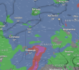
The cloud base report is a quick visual of VFR conditions.
View attachment 123797
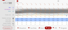
The route planner shows an excellent vertical cross section for cross country planning purposes.
View attachment 123798
dcat127
Pre-Flight
- Joined
- Jun 30, 2020
- Messages
- 74
- Display Name
Display name:
Electro
I have Geneva saved as a favorite.Is there any special reason your map has a heart on Geneva?
I appreciate the replies. I think Windy will be my best bet and has most of what I was looking for. I never really dug into it much even during training. My instructor and I would sometimes use it if things were marginal and occasionally made both go and no-go decisions (and each time, each call was the right one).
Ed Haywood
En-Route
I use the 48 hour frontal maps at https://www.wunderground.com/maps. Anything past that is mostly guessing based on continent-wide patterns and developing systems. The weather channel usually does a good job giving overviews of that.


