Approach trivia: KPHH NDB IAP is gone

asicer

Final Approach
Joined
Jan 1, 2015
Messages
9,559
Display Name

Display name:
asicer
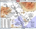
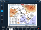
For a while, KPHH was the only airport in the d-TPP that had an NDB IAP but no RNAV IAP. Looks like that's no longer the case as of the Nov 3, 2022 chart cycle. There's now a RNAV(GPS)-A and the NDB IAP has been removed.

So I guess everyone can start pulling out their ADF now. :)
 
I kind of wish I could show a green co-pilot how to shoot an ADF approach. Most of them have never shot one. I did hundreds and was quite good at them. Last one I did in actual conditions was around 2008. Did them in the sim for a few more years. We no longer have an ADF in the Citation.

I wonder if my Dad thought the same about the old Range approaches he shot in DC-3's?
 
If you were fairly practiced at them, they were fun. The last one I did was actually a GPS overlay. The company said all the ADF receivers were removed from the fleet. They weren't.
 
a moment of silence please

Even though they were partially the cause for my bust on my first IR ride, I still say there's absolute beauty in the simplicity of the ADF. Depending on how it was set up, the approaches could be VERY simple or could be a real tangle

I still say an inexpensive low power NDB station on nearly every airport and lightweight modern ADF radios in planes would make for a wonderful GPS backup.
 
It's a dirt simple thing that went away in favor of something that requires billions of dollars worth of satellites and several hours worth of manual reading for a pilot to be able to properly use the receiver. :D
 
It's a dirt simple thing that went away in favor of something that requires billions of dollars worth of satellites and several hours worth of manual reading for a pilot to be able to properly use the receiver. :D

Hmmm. Your words are strange and have no meaning to me.
 
It's a dirt simple thing that went away in favor of something that requires billions of dollars worth of satellites and several hours worth of manual reading for a pilot to be able to properly use the receiver. :D

And they sometimes broadcast a ball game. We had one close at Carlisle, PA, but it to has ceased to be.
 
There used to be an NDB with glideslope at Grand Rapids, MN. :D
 
Last edited:
Maybe in another 20 years they’ll take adf questions off the written tests.
 
Early 90s…they installed an ILS with the NDB as a compass locator, but couldn’t publish the plate for about a year.:D

That's long before I started flying in there. It would be interesting to see a copy of that approach plate.
 
They are called Non directional beacon approaches. An automatic direction finder is the usual equipment used. But, before the ADF there was the Low freq receiver with a manual loop. I recall that gear in the old "A" model Birddogs. One of our National Guard unit's four WW2 pilot vets once put me in the backseat to safety him. He put on the hood and did a flawless, no sweat NDB approach. The LF receiver, the loop control and the mechanical bearing indicator are installed in the left wing root aft of the pilot's head.
I got my intro to LF DF when I was a preteen visiting my uncle's ship moored at a Boston pier. (My family were all sea dogs. I went bad and got into aviation.)
The loop antenna was mounted in the ceiling of the bridge and had a handle to turn it. We tuned in WHDH AM and turned the loop until the signal faded. It is called a "null". I read the relative bearing, went to the compass, noted the MH, did the math and got a mag bearing TO WHDH. My uncle said a bearing is "From me to thee." Add/subtract 180 degrees and I got a bearing FROM. (not called a radial on his ship) This was a Line of Position (LOP).
Life sure got simple in the 90's when a GPS showed up in my panel.
 
Last edited:
Didn't they also used to publish certain AM radio stations on the sectional charts as well?
 
Early 90s…they installed an ILS with the NDB as a compass locator, but couldn’t publish the plate for about a year.:D
That wouldn't be "...There used to be an NDB with glideslope at Grand Rapids, MN..." I thought you was meaning that literally the NDB was the Final Approach Course and there was a stand alone so to speak, Glideslope. ILS's with Compass Locators were very common until NDB's started getting decommissioned all over the place a few years ago.
 
That wouldn't be "...There used to be an NDB with glideslope at Grand Rapids, MN..." I thought you was meaning that literally the NDB was the Final Approach Course and there was a stand alone so to speak, Glideslope. ILS's with Compass Locators were very common until NDB's started getting decommissioned all over the place a few years ago.
Hence the :D
 
So I guess everyone can start pulling out their ADF now. :)
I guess everyone needs to re-install their ADF again. KMNI has a NDB approach and no other way to get in IFR. Looks it used to be "NDB or GPS" but as of 10Aug23 it went to NDB-only.
 
I guess everyone needs to re-install their ADF again. KMNI has a NDB approach and no other way to get in IFR. Looks it used to be "NDB or GPS" but as of 10Aug23 it went to NDB-only.
May as well put in dual ADFs while you’re at it…then you can have FUN!
1695307089007.jpeg
 

Attachments

  • 1695306977702.png
    1695306977702.png
    1.1 MB · Views: 8
Hey, there are plenty of NDBs out there. They are just known by their regular name - AM radio stations! Lol
My father, 85 years of age, recalled tuning into AM stations to triangulate his location. Of course, the go to standard was always circling a water tower. ;)
 
Of course, the go to standard was always circling a water tower. ;)

My favorite story about that was told to me by one of my clients, from his Private Pilot training (this is fairly recent too).

He's on a solo XC flight, gets a little lost, decides to try the water tower trick. Flies down, sees a grain elevator, it says "Corn".

1695838611613.png

He thinks, yeah, it's Oklahoma, big deal, so they store corn in there, that's not helpful. He climbs back up and eventually figures out where he is. Later he looks at a map, and sure enough, he was over Corn, OK, population 503!
 
My father, 85 years of age, recalled tuning into AM stations to triangulate his location. Of course, the go to standard was always circling a water tower. ;)
I learned to fly in the mid 1960s at Fullerton CA. Less than two miles from the airport (and a real hazard to the traffic pattern) was the 700-foot-high transmitter of KFI radio, a 50,000-watt, clear-channel blowtorch. For those of us old enough to remember the little Cold-War-era triangles on the AM radio dial, KFI (640 kc) was also a CONELRAD station. Its signal was so strong, we could hear it over the dial tone on our home phone. My mother swore she could hear it in the fillings of her teeth.

With an ADF aboard, KFI was great for finding one's way back to the hive. You could home in on that thing all the way from Mars. As an added benefit, KFI carried the Dodgers play-by-play broadcasts in those days, so there was something to listen to.
 
But how will I listen to football on a Sunday afternoon while flying?
Ask AOPA to lobby for re-purposing the decommissioned HIWAS stations that are still on the MON? (NFL Advisory Service = NFLAS)

Maybe scores could be sent over UAT (sports information service = SIS-B)
 
Back
Top