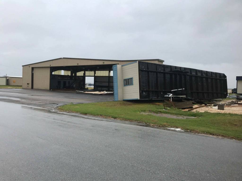
Send good thoughts and prayers to Jay Honeck

This may seem trivial, but I gotta say... the paint on all three vehicles in that pic is amazing. Almost looks like a CGI render of a hangar.

Good luck. I rode out 3 (Charley, Francis, Jeanne) in Orlando. It's not fun, and my plane and business wasn't in the line of fire. It sucks.
 
Definitely going to be nasty in that part of the state for days and weeks to come. For those that are interested, you can go to broadcastify.com, select Buffalo, New York, feeds and select the tab for Hurricane Watch, and listen to the net feed. There is a little going on now, but will be more active tonight as the storm comes ashore. If you have hf gear, the nets run on 7.268 Mhz and 14.325 Mhz.
 
Current wx:

KRAS 252055Z AUTO 35045G56KT 1/2SM RA OVC007 24/24 A2927 RMK AO2 P0085 60217 T02400236

Conditions at:
KRAS (PORT ARANSAS , TX, US) observed 2055 UTC 25 August 2017

Temperature:
24.0°C (75°F)
Dewpoint: 23.6°C (74°F) [RH = 98%]
Pressure (altimeter): 29.27 inches Hg (991.3 mb)
Winds: from the N (350 degrees) at 52 MPH (45 knots; 23.4 m/s)
gusting to 64 MPH (56 knots; 29.1 m/s)
Visibility: 0.50 miles (0.80 km)
Ceiling: 700 feet AGL
Clouds: overcast cloud deck at 700 feet AGL
Weather: RA (rain)
 
METAR text: KRAS 252117Z AUTO 24/24 RMK AO2 PWINO TSNO
Conditions at:
KRAS (PORT ARANSAS , TX, US) observed 2117 UTC 25 August 2017
Temperature: 24.0°C (75°F)
Dewpoint: 24.0°C (75°F) [RH = 100%]
Pressure (altimeter): missing
Winds: missing
Visibility: missing
Ceiling: unknown
Clouds: missing
Weather: automated observation with no human augmentation;
there may or may not be significant weather present at this time
 
Weather Station: missing

That's what I'm thinking. Sensors blown off, or exceeding their limits! :eek: I really do hope that all goes well for Jay and company, but really I wish the best for everybody that lives down that way. Jay is going to come out of this a whole lot better than some that live there. I really do hope the storm is over estimated and either changes course and goes back to sea, or blows itself out before landfall.
 
That's what I'm thinking. Sensors blown off, or exceeding their limits! :eek: I really do hope that all goes well for Jay and company, but really I wish the best for everybody that lives down that way. Jay is going to come out of this a whole lot better than some that live there. I really do hope the storm is over estimated and either changes course and goes back to sea, or blows itself out before landfall.
Naw, just loss of data connection.
 
Thinking about you all day...150 miles north on the coast and dodging the worst...took the eye wall of Ike and fared okay in 2008 ... this is nothing in comparison...let us know how we can help...have truck generator and time to help...
 
Looking at the weather radar on Garmin Pilot the eye is coming ashore to the NE of them. Thus, the winds are blowing off shore. This may help. Fingers crossed.
 
Looking at the weather radar on Garmin Pilot the eye is coming ashore to the NE of them. Thus, the winds are blowing off shore. This may help. Fingers crossed.
What little news that is getting out of Aransas and Rockport isn't good. Let us hope that it is. Better in daylight than it seems tonight. Goiter...
 
Best wishes to Jay and family. According to NBC news, Cat 4 hurricane hit Port Aransas last night with 131 knot winds. "Catastrophic flooding" is now predicted.
 
Question for meteorology / oceanography / topography smarter than me folks: absent storm surge, and given the flatness of a barrier island and the vast reservoir of the sea right there and just 12 feet down, why are we so concerned about flooding? Further inland, with slight variations in the surface and funneling, I can understand, but should not Port A and such be spared?
 
Last edited:
Question for meteorology / oceanography / topography smarter than me folks: absent storm surge, and given the flatness of a barrier island and the vast reservoir of the sea right there and just 12 feet down, why are we so concerned about flooding? Further inland, with slight variations in the surface and funneling, I can understand, but should not Port A and such be spared?

I assumed the issue was the storm surge, which brings a surge of water inland. It would recede from higher ground fairly quickly, but even a brief flood of a couple of feet of water will do an incredible amount of damage.
 
Weather.com was reporting 101 mph sustained winds at Port Aransas last night, I have to think there's some significant damage there.
 
Weather.com was reporting 101 mph sustained winds at Port Aransas last night, I have to think there's some significant damage there.
We have been unable to contact anyone in Port A. People who have tried to drive in have been unable to get past debris.

I spoke with the wife of a Port A LEO this morning. They sheltered in place but are unable to get out. They are awaiting airlift.

Sent from my SM-T700 using Tapatalk
 
And now Facebook -- the app everyone here is using to check in after the storm -- has crashed nationwide.

Damn....

Sent from my SM-T700 using Tapatalk
 
Trying to think about something positive: it looks like the eye passed just east of Port A. That's good, as the sustained winds at the eye wall are 10 kts lower due to the movement of the eye itself. Another benefit of being West of the eye is that the sustained winds for the next couple of days will be southerly, thus hopefully mitigating somewhat the storm surge.

Jay and Mary-- we're hoping the best for you, relieved to know you are out of harm's way, and glad you are in a place that will not run out of Shiner's. Maybe now would be a good time to stock up on some 750ml bottles of Chimay Blue. Tim and Mary (N704PA, KRBD).

Sent from my Nexus 5X using Tapatalk
 
We have been unable to contact anyone in Port A. People who have tried to drive in have been unable to get past debris.

I spoke with the wife of a Port A LEO this morning. They sheltered in place but are unable to get out. They are awaiting airlift.

Sent from my SM-T700 using Tapatalk

I checked one of he corpus tv stations this morning, and they had a reporter and cameraman driving up 361. All the utility poles, which are on the west side of the road, were leaning at about at 30 degree angle toward the road. When they got to the Methodist church, they stopped there. The metal roof had been peeled back like the top of a sardine can.
 
Glad Jay and fam are safe. Like he said, everything else is replaceable. But no one wants to replace things. Hoping good things and good fortune.

I like the weather report. "there may or may not be significant weather present at this time"
 
Last edited:
Jay, I am glad you guys got out safely and I hope you have minimal damages! One of my co-workers has family near there and they refused to leave because of "looters"!! They were OK as of this morning, but the pictures didn't look too good.
 
AME of those photos are not far from Amelia's landing.
 
AME of those photos are not far from Amelia's landing.
Remember when the airport stopped reporting the WX?

21077592_10214361304132155_2479371521400434370_n.jpg
 
so everybody is freaking out down here and storming the walmart...i needed to investigate what the hysteria was all about.... so naturally I went flying :D
20170826_152333.jpg

this place is so desolate and irrelevant even Harvey decided to skip it lol. as a PR native I have to remind myself that cyclones are eclipse-like events for the conus dwellers. for me it's just another day to practice crosswind landings.

I did check another box from my bucket list.:D. and no, I promise the insurance check wasn't part of the decision making matrix for this one lol.
 
Great news! In an airport full of hurricane devastation, our hangar survived unscathed. (The last photo.)

It's a freaking miracle. There is no explanation.
03930017bda2e1dc3c507da63efc8c66.jpg
189928208a862c7cdf21668486669f3f.jpg
1acea21e5dc4759bec0a9dec134444b7.jpg
bb368697735744133cadf9bd238f8d7c.jpg
7742e3aa2d678e99a32264e043f41842.jpg


Sent from my XT1650 using Tapatalk
water damage?
 
Back
Top