
Where does AOPA get Airport Diagrams from?

SkyHog

Touchdown! Greaser!
Joined
Feb 23, 2005
Messages
18,510
Location
Middle of nowhere Texas
Display Name
Everything Offends Me
Home Airfield
KLUD
I thought it might be from the chart supplement or from the published taxiway diagrams, but apparently it must be from somewhere else.

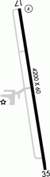
Case in point, KLUD - the diagram is different in the chart supplement and on AOPA's airport information page. I like AOPA's better - but where does it come from?
 

Attachments

  • tn_LUD_tif.gif
    tn_LUD_tif.gif
    2.9 KB · Views: 28
  • Screenshot_20260308-112010.png
    Screenshot_20260308-112010.png
    154.6 KB · Views: 28
It looks like the one on AOPA is an older chart supplement version. Out of curiosity, why do you like that one better? It has virtually no detail information. It's also very similar to the one on the Decatur Jet Center's webpage, which also makes me think it's an old chart supplement version. https://decaturjetcenter.com/
 
I thought it might be from the chart supplement or from the published taxiway diagrams, but apparently it must be from somewhere else.

Case in point, KLUD - the diagram is different in the chart supplement and on AOPA's airport information page. I like AOPA's better - but where does it come from?
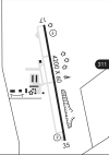
The uncluttered one on the left is he approach plate thumbnail; the more detailed one on the right from the Chart Supplement. I think @JVerb is correct about the age. I think the two used to be the same and then the FAA started going into a little more detail for the Chart Supplement.
 
As mentioned,
-AOPA version appears outdated (image hosted on AOPA website)
(this version also in AOPA Kneeboard Format)

-Chart Supplement appears current/accurate for runway and airport diagram.
-Airport Sketch in lower corner of IAP charts also current for runway and airport diagram.

AOPA Airport Directory can be useful. For unfamiliar, non-towered airports, I typically print their Kneeboard Format.
Although data is mostly (direct from) Chart Supplement, I'll trust but verify.
 
Last edited:
Also keep in mind the Airport Sketches (the name for the thumbnail on the approach charts) are getting LESS detailed due to a fairly recent policy to declutter them. They are now not showing the taxiways and other extraneous items, I believe in concert with a program to publish official airport diagrams for more airports.
 
Back
Top