What aviation apps are you using? Android version

FORANE

En-Route
Joined
Mar 7, 2013
Messages
3,536
Location
TN
Display Name

Display name:
FORANE
With the recent, ahem, "improvements" on the aviation weather center website, I've been looking for workarounds for the information I used to get from the aviation weather center website. I still use AWC, but believe it is harder to use on the phone in particular and makes me less safe in the air.

Apps and webpages I am using now:

Skyvector webpage with text weather (meters) radar and TFR's turned on.

Aeroweather app for quick access to metars, TAF's, freezing level, etc at multiple airports I am interested in. It's nice as it displays how old the metar is without having to calculate it.

Windy webpage for map with satellite and webcams.

What are you using?
 
Apps: Avare for EFB, Avia Weather for quick check of local airports, GPSLogger to record flights.

Web: Weather Underground for planning out to 10 days, Launch Code for shorter range planning including ceilings. Airnav for airport info. NWS Graphical Forecast and Windy sometimes, 1800wxbrief for an "official" briefing.
 
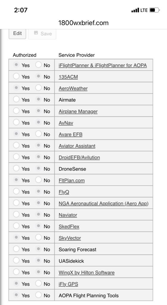
Avare is nice and free, but I find the UI hard to use. I'd rather pay for an app that has a better UI.

SkyVector is free and has Canadian charts, but is a bloated piece of crash-ware on every device I have owned over the years. I love their web site, hate their Android app.

Naviator and Droid EFB (formerly Avilution) are my 2 favorite apps and I maintain current subscriptions with both. In comparison:

Both:
Seamlessly stitched charts
Easy route building, by entering waypoints or touching on-screen.
Connect over BT to external GPS
Connect over GDL-90 WiFi to ADS-B receivers (like Stratux and others)
Falls back to internal GPS, if it exists
Create flight tracks and save/upload to their servers
Regular updates and responsive support

Droid EFB:
Faster, smoother response (you can tell the difference even on fast tablets)
Longer battery life (app is less of a battery hog)
Smooth zoom: can zoom the map to any level large or small (not step-zoom)
Automatically synchronizes waypoints and routes across all devices
Shows PIREPS (Naviator doesn't)
Shows wind (Naviator doesn't)
Better night mode
Better display of ADS-B "in" traffic
Shows fuel prices
Built-in Weight & Balance app
Has exact printed copy of AF/D and airport diagrams

Naviator:
Better graphics & chart detail (vector graphics: sharper when zoomed in close)
Step-zoom only: zoom only to predefined steps, so sometimes you can't get the zoom you want because it's between levels
Terrain DB with colored warning areas on charts (Droid EFB only highlights obstacles, not terrain)
Better online web "Hangar" listing & displaying your flights
Terrain, airports, and navaids (VORs, NDBs) cover Canada -- but not charts
Altitude optimizer (but only during pre-flight (internet connection), not during flight (ADS-B in weather), since Naviator doesn't process wind from ADS-B in).
Cheaper annual subscription

Overall Droid EFB is my primary app, mainly because of longer battery life in-flight, better handling of ADS-B "in" traffic, and syncing all your waypoints & routes across all your devices and they never get deleted even if you completely uninstall the app. But Naviator is a good app and I like having a completely separate app (and device) as a backup.
 
1800WXBRIEF works well on mobile browsers.
+1 for Avare. Not the best IFR platform, but still great for SA and very minimalistic on resouce use. I have a couple tablets running Android 5 and 6, probably 10 years old or so, and they have no problem running it. Try that on iOS.
 
I was going to suggest an app I like called "windsock", but I looked at aeroweather and it looks like it does all the same things plus more. I really like having that quick & simple look at taf's and metars in the area of along my path. I also like having the widget with my local weather on my homescreen. I feel like I tried aeroweather in the past and it didn't work, but it seems to be now.
 
I was going to suggest an app I like called "windsock", but I looked at aeroweather and it looks like it does all the same things plus more. I really like having that quick & simple look at taf's and metars in the area of along my path. I also like having the widget with my local weather on my homescreen. I feel like I tried aeroweather in the past and it didn't work, but it seems to be now.
+ 1 for Aeroweather
 
I also like having the widget with my local weather on my homescreen.
Every time I see widget I have to read it in an English accent. My sister's college roommate at U of I, her dad is English and was also my soccer trainer. He drank Boddington's because "it has a widget". Apparently stale warm beer is an English thing. Going out to the bars he ordered a pitcher of Guinness. I don't drink beer, but nobody else was drinking the Guinness. So me and him reminisced and drank beer thick enough to chew. Then he ordered another pitcher. Ugh.

As far as apps, I still have the just zulu app. Doesn't get much use anymore but it's on my phone. Everything else has already been spoken for.
 
1800WXBRIEF works well on mobile browsers.
+1 for Avare. Not the best IFR platform, but still great for SA and very minimalistic on resouce use. I have a couple tablets running Android 5 and 6, probably 10 years old or so, and they have no problem running it. Try that on iOS.
1800WXBRIEF works well on mobile browsers.
+1 for Avare.
I wasn't aware 1800WXBRIEF was more than a phone number. I like the website, thanks.

Been using avare for a few years now, ever since anywhere map stopped providing regular updates. Wish avare had the fabulous emergency view ground impact arc that was present in AWM PRO. With that arc I could cut the throttle to idle at 10k and 10 miles out and make the runway easily by simply keeping the arc on the runway threshold.
 
IFly gps on a samsung tablet and an iPhone. Aeroweather pro on both. Flight aware on both. 1800WXbrief.com.

If your an AOPA member you have access to their web-based version of iflightplanner. Plans created there can be imported to IFly pretty seamlessly.

For 1800WXBrief, go to Account>Service Provider Authorization and tie in your EFB and other sites/tools you use to get your weather brief; this creates an evidentiary trail you got the info.

e121eb21a318763751dfe21cb0011401.jpg
 
Back
Top