benyflyguy
En-Route
Just saw this over on Reddit. Wild video. Overweight, inexperienced, high DA. What could go right??!!
The Embraer EMB-721 Sertanejo series were Piper PA-32R Lance/Saratoga aircraft built under license in Brazil.
I had to look it up.
Did they take off from the grass? Or immediately upon liftoff drift left over the infield? Or was it an optical delusion?
Looked to me like he lost control of the airplane before liftoff and had a brief roll in the grass before liftoff.I had to look it up.
Did they take off from the grass? Or immediately upon liftoff drift left over the infield? Or was it an optical delusion?
") and on floats if the water level is below the top of the pontoon it isn't overweight overseas if you can get one more paying customer in it isn't full
and on floats if the water level is below the top of the pontoon it isn't overweight overseas if you can get one more paying customer in it isn't full 
That looks like Concrete, WA (3W5), elevation 267. The narrator characterizes the field as "a very short runway." For God's sake it's 2600' long. That's NOT "very short." That's not even "short."vEriCaL ViDEo iS ThE BeST!
also, reminds me a bit of this FlightChops video from a few years ago, at least this is in landscape mode.. also fast forwarded to 1:00
I just checked Mears field on SkyVector. Apparently the runway is 60 foot LONG and 2906 foot WIDE...That looks like Concrete, WA (3W5), elevation 267. The narrator characterizes the field as "a very short runway." For God's sake it's 2600' long. That's NOT "very short." That's not even "short..."
The (-late 80s) 3000 foot long gravel runway at HSL (Huslia Alaska) sat in a crook with a vestigial hoop lake adding to the fun. Technically 3/21, we called it 3/20 because it had literally been built in a gentle arc (to the right as one looked NNE) where the ground was firm enough to support a runway.Concrete... lays in a crook of the Skagit River. Either direction, landing or takeoff, you pass over the river. In the summer, the water is snow melt, ice water, and it creates little sink holes at each end of the runway...
Check the Seattle sectional and AirNav.com.I just checked Mears field on SkyVector. Apparently the runway is 60 foot LONG and 2906 foot WIDE...Well, it is in portrait mode.
That looks like Concrete, WA (3W5), elevation 267. The narrator characterizes the field as "a very short runway." For God's sake it's 2600' long. That's NOT "very short." That's not even "short."
If you watch the first few seconds as the plane turns onto the runway, there is some indication of a tailwind in the trees and bushes to the left. Hard to know for sure.
An interesting thing about Concrete is it lays in a crook of the Skagit River. Either direction, landing or takeoff, you pass over the river. In the summer, the water is snow melt, ice water, and it creates little sink holes at each end of the runway.
Rising up has a turbo Bonanza at MGW with a ground roll of 1176' and a 50-foot obstacle clearance of 2012'. Obviously, we don't know the DA, but to me, it seems something else must have been amiss.
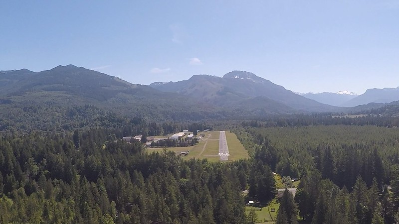
Concrete and Darrington are great for teaching new pilots respect for take off and landing performance because they are just barely challenging enough you have to pay attention. PPLs who only ever see the easy runways are a little shell-shocked when they see those knob hills, the trees and the river, all so very close.
also, reminds me a bit of this FlightChops video from a few years ago, at least this is in landscape mode.. also fast forwarded to 1:00
The narrator characterizes the field as "a very short runway." For God's sake it's 2600' long. That's NOT "very short." That's not even "short."
Yeah, Washington is the only place you see terrain out your window on takeoff. You bet.

I've posted this photo before of my first visit to Darrington (1S2) in my Warrior. Guess what's going on in the lower right?
I’m hoping they’re not just burying him where he augered in.I've posted this photo before of my first visit to Darrington (1S2) in my Warrior. Guess what's going on in the lower right?
View attachment 102773