Weather Question

Well, I do rent from flying clubs :rolleyes:
I noticed that Hobbs/Tach may vary within a club - may depend on aircraft and how owner sets it up. There was nothing 'per tach' that was even remotely similar to what I wanted to fly and was within distance I was willing to drive.
Hmmm, around here, many places seem to charge by the tach.
 
Worry, no. But I think it can be enjoyable to think of all the little (safe) ways to cut costs. Determining your optimal cruising altitude, experimenting with leaning techniques, optimizing your climb and descent profiles, etc. The cost saving mindset can go too far, but I wouldn't ever discourage someone from seeking and adopting more efficient/cost effective flying habits. (I'm sure I'm preaching to the choir. ;) )

To an extent but even then I've gotten to where I'll gladly fly into a headwind if it means a smooth ride. My days of hugging the ground to try and stay out of it while getting slammed around in turbulence for hundreds of miles are over.
 
I don't think about it when i'm flying, but I sure as hell do when i'm rolling around on the ground..

kim try vfrmap.com
Things get to the point to where thinking about the idling cost of rolling around on the ground is a safety issue. One really really needs to have their **** together before they depart into IMC at minimums. I spend a lot more time double and tripple checking things before I go.

As a owner it doesn't matter much - you're not burning much fuel. As a renter the idling costs are quite high but operationally it doesn't matter to your flight much because once again you're not burning much fuel. Therefore as a renter I try and think like an owner to avoid that cost pressuring me into rushing.
 
Last edited:
I found being prepared before you start the engine can save you quite a bit extended idling, figuring out where the fbo is when you land, etc. Also get your atis, set frequencies, headings etc before startup. Unless its really cold and the engine needs to warm up you can probably start, taxi, and run-up in .1.
 
Sorry, stolen from David (he doesn't know):

429499_2785665881298_1247804014_32109008_903377179_n.jpg
 
I found being prepared before you start the engine can save you quite a bit extended idling, figuring out where the fbo is when you land, etc. Also get your atis, set frequencies, headings etc before startup. Unless its really cold and the engine needs to warm up you can probably start, taxi, and run-up in .1.

I'll probably take .2 but yes I need to get faster and more organized. I'm gonna ask the boyfriend to drive my car to the airport (so I can sit right seat). It takes roughly 30 minutes to drive there from his house and I will mentally run through my flight and all the steps and organize my paperwork....
 
Question about weather again:

How can I view PAST metars (hoping they will be translated)? Every airport except Monterey looks great on Saturday (they say clouds below 500). What I'd like to do is keep track of a few (perhaps 5-10) key airports' hourly ACTUAL cloud / wind information so I can look at Saturday and Sunday and Monday.

Is this possible?

http://www.jesseweather.com has historic metars and trending for pretty much every station in the US. The forecast/taf feature may be busted. haven't looked at it in awhile.
 
An added benefit (besides free parking with ten gallons of fuel) of choosing the Jet Center:

6965302441_f52c9ebdc8_o.jpg
 
Those black uniforms just don't cut it in my book..... :nonod::nono::wink2:
 
I just finished reading the 2009 AOPA Nall report (after some local training).
Electing to fly in adverse weather is one of the 3 largest accident categories.
It's significant because most private pilots have 100% control over the decision to go or not. I really like understanding topics like that, so it's fun for me. I do recommend taking the extra time to read up and review the subject.
 
I learned long ago that I HATE renting by the Hobbs. When I was looking for a flying club, one of my strong preferences was that they charge by tach time.

Kim, have you considered going that route? If you spend a lot of time taxiing and doing your runups, it could make a significant difference in cost. (not to mention waiting for clearances/releases once IR)

He did the math and it would have cost more (just called him about this). Plus I don't think they will change the rules for a renter who gives them a few hundred dollars.
 
PAST metars (hoping they will be translated)?
I hope in your zeal to digest weather data you won't forget about TAFs since they give you forecast what weather WILL be like at some airport. I personally would rather spend all this effort on studying the future than the past.
 
Last edited:
He did the math and it would have cost more (just called him about this). Plus I don't think they will change the rules for a renter who gives them a few hundred dollars.
Only because he chose to multiple it by 1.3.
 
I hope in your zeal to digest weather data you won't forget about TAFs since they give you forecast what weather WILL be like at some airport. I personally would rather spend all this effort on studying the future than the past.

Only because he chose to multiple it by 1.3.
Well, did he actually have the tach readings from before and after the flight? If you were idling for a significant portion of time, the tach hours should have been significantly lower than the Hobbes hours.
 
I hope in your zeal to digest weather data you won't forget about TAFs since they give you forecast what weather WILL be like at some airport. I personally would rather spend all this effort on studying the future than the past.

Yes but I'll be comparing the FORECASTED CONDITIONS with the actual. That is what I meant. So we'll see if they were "close".
 
Well, did he actually have the tach readings from before and after the flight? If you were idling for a significant portion of time, the tach hours should have been significantly lower than the Hobbes hours.

Yes, he did, we write them in a binder and he pulled up the binder. He also told me the G1000 172 (a newer 172, the new ones have the 180hp option) - just flew to Half Moon Bay and paid 1.4 hobbs. So my 1.7 in a 150 isn't that off.
 
Wishing you tail winds and clear skies for your trip if you do indeed decide to fly. I admire your level of preparation for this trip- definitely makes a new private pilot like myself notice how others plan for long XC's.
 
Wishing you tail winds and clear skies for your trip if you do indeed decide to fly. I admire your level of preparation for this trip- definitely makes a new private pilot like myself notice how others plan for long XC's.

This area just sucks for weather in terms of it sneaking up on you. The planning I haven't really done but will do today / tonight:

Print outs - flight plan, airport diagrams, noise abatement, google sattelite photos
Way points - decide!
Alt airports - decide!
File a flight plan (I'm gonna try it on Foreflight and then ask during my phone call the next day if they got it)
AWOS map (I don't get data in flight so if I want to get wx I'll have to call flight service or try to pick up nearby AWOS's). This is a "new" idea.
 
Strange, in comparing the "kneeboard format" printouts from AOPA airports to the AFD listings, they seem to be missing something very important - the airport elevation. Odd.
 
Flight planning is done on ground speed, that's why we call for winds aloft. Using historic speeds across a route is actually a pretty solid way of doing things if you take into account what the general prevailing conditions are.

For ****s and giggles, I pulled up my O69 to Monterey invoice from January. It was 3.1 hours - I followed the coast line, at a lower altitude, but Monterey is almost exactly half way. That was in the 152.

So it seems like 6.2 with no mid way stops and a constant 5500 altitude may be a reasonable estimate. It is too bad, I was hoping to be well under 6 hours. C'est la vie.
 
He did the math and it would have cost more (just called him about this). Plus I don't think they will change the rules for a renter who gives them a few hundred dollars.
Actually, I meant looking for a flying club. I don't know of any FBOs around here that rent by the tach hour.
 
Dear Kim,

Stop looking at the Monday weather thinking that you'll actually know how it impacts your flight on Monday.

Signed,

Everybody that has already told you that

:)
 
Dear Kim,

Stop looking at the Monday weather thinking that you'll actually know how it impacts your flight on Monday.

Signed,

Everybody that has already told you that

:)

Actually, I was just talking to a briefer since the MOA / Restricted is "as published" and I think my sectional expires as of today. Darned areas force me inland as they are constantly active from surface to 15,000 feet.

But thanks, I'm not looking at Monday, I'm coming back on Sunday, remember? Also, now the BF won't tell me if he's coming with me. He may stay the day and come back with his folks. Solo flying, whoopee. Will be an adventure for sure.
 
When I first got my PPL I was eager to take friends flying with me anywhere and everywhere. My first long XC after the checkride was to MCD with a friend, on a day when it was windier than I had ever flown in before. The first time I landed in a 50 degree crosswind, 16G23KTS was that day. Today, if I expect to be in conditions that are outside my "comfort zone" (but NOT outside my personal limits, or I wouldn't go up at all), I usually prefer to be solo. Fewer distractions, and (at least) one less person to be responsible for.
 
When I first got my PPL I was eager to take friends flying with me anywhere and everywhere. My first long XC after the checkride was to MCD with a friend, on a day when it was windier than I had ever flown in before. The first time I landed in a 50 degree crosswind, 16G23KTS was that day. Today, if I expect to be in conditions that are outside my "comfort zone" (but NOT outside my personal limits, or I wouldn't go up at all), I usually prefer to be solo. Fewer distractions, and (at least) one less person to be responsible for.
MCD with a significant wind can play havoc with the bluffs there. Must have been "interesting!"
 
Not as interesting as the following year, when it took me three tries to land in winds that were reported as nowhere near as strong as that (8G14 I think). I really should have given up, it turned out to be blowing from several directions at almost the same time, really squirrely and I could have easily bent metal. That first time with my first pax was a charm though -- a perfect, solid landing on the first try. Classic beginner's luck.
 
Actually, I was just talking to a briefer since the MOA / Restricted is "as published" and I think my sectional expires as of today. Darned areas force me inland as they are constantly active from surface to 15,000 feet.

But thanks, I'm not looking at Monday, I'm coming back on Sunday, remember? Also, now the BF won't tell me if he's coming with me. He may stay the day and come back with his folks. Solo flying, whoopee. Will be an adventure for sure.

BF may have decided you're gonna drive him nuts with all the worrying. Heh heh. ;) ;) ;) Just kidding. Maybe. ;) ;) ;)

If you fly out West, MOAs are a way of life. Get Flight Following and they'll let ya know if you're in the way of the fast movers. Folks have mentioned that too. ;)

You're getting tunnel vision and not listening to folks who've "been there, done that". Stress does that. Relax. Enjoy yourself.

There's no need to go out of your way to go around MOA's. They don't "force" you to do anything at all.

Restricted is a different story. They're small. Go around those. ;)

Recommended things in MOAs are the same as in any airspace as crowded as much of California is.

Eyeballs outside looking for traffic. Flight following. Talk to the controllers. They're nice folks. They want to help you get where you want to go.

I'd take a hot MOA with Flight Following (except maybe stuff around Nellis during Red Flag or another large exercise) over the LA Basin for VFR traffic watch, and travel, any day of the week.

Military pilots look outside and big stuff has extra eyeballs on board. They're pros who know they're flying fast stuff with closure rates multiples higher than your top speed. If their controllers tell them you're there (flight following... oh, and did I say flight following?) they'll stay away from you.

Or if they're really bored they'll form up on you about a 1/2 mile away. ;)

(Looking out the side window once on a practice CAP search mission to see a C-130 matching speed and altitude 1/2 mile off the wingtip in Southern Colorado, was cool.)

The sky is dynamic. In order to be a student of the sky, you just have to get up in it and keep your options open. Know your "out" and use it if the brain says "this doesn't look right".

You've seen MVFR weather. You'll know it if you're flying into it. Trust yourself. Your eyeballs aren't going to lie to you. (You're not blasting off into embedded thunderstorms -- that's one case where the eyeballs can be deceived.)

It's really too bad there's not another pilot around to ride along. It'd lower your stress level and if they're good at mentoring, you'd get plenty of practice making in-flight weather decisions with a little help in the right seat to give confidence.

Given the right weather conditions on the big picture map, I'd launch with ya and enjoy the ride, while you got all the "fussing" out of your system. ;)

I'd recognize it too. I used to do it. I got over it.

(And as Jesse showed me, real IFR weather is a much much harder a decision than VFR weather.)

I really learned a lot (both good and bad) from some early ride-alongs on VFR XCs with other pilots. A few trips down the road you'll feel a lot more confident about simple/short trips.

Then budget and time will eventually converge to allow a bigger trip and you'll get that "wow, I flew from one major weather pattern/system to another" and see how the briefing really can't account for all the changes possible in six or eight hours.

I'm hoping for good weather with a little bit of isolated clouds or precip somewhere along the way that's easily seen and avoided in flight for ya, just for the learning experience.

Right now, the pros think that front that's off the coast will become stationary and there's a big bubble of high pressure peeking into this map from the West. That's a good sign for you. That's about all you can tell right now. The north end of your route will probably be a little weather. The further south you go the better. Inland also looks like a solid "out" all the way.

aefdbb1e-a906-ea53.jpg


If that map doesn't get any more squirrelly, and there's not some weird local coastal thing going on, that is a "go" map to me. But it's still too early to tell. And it's your call.

Look for things over the time between now and the flight that close off your "outs". If your outs are dwindling, reassess. If not, enjoy the flight. ;)
 
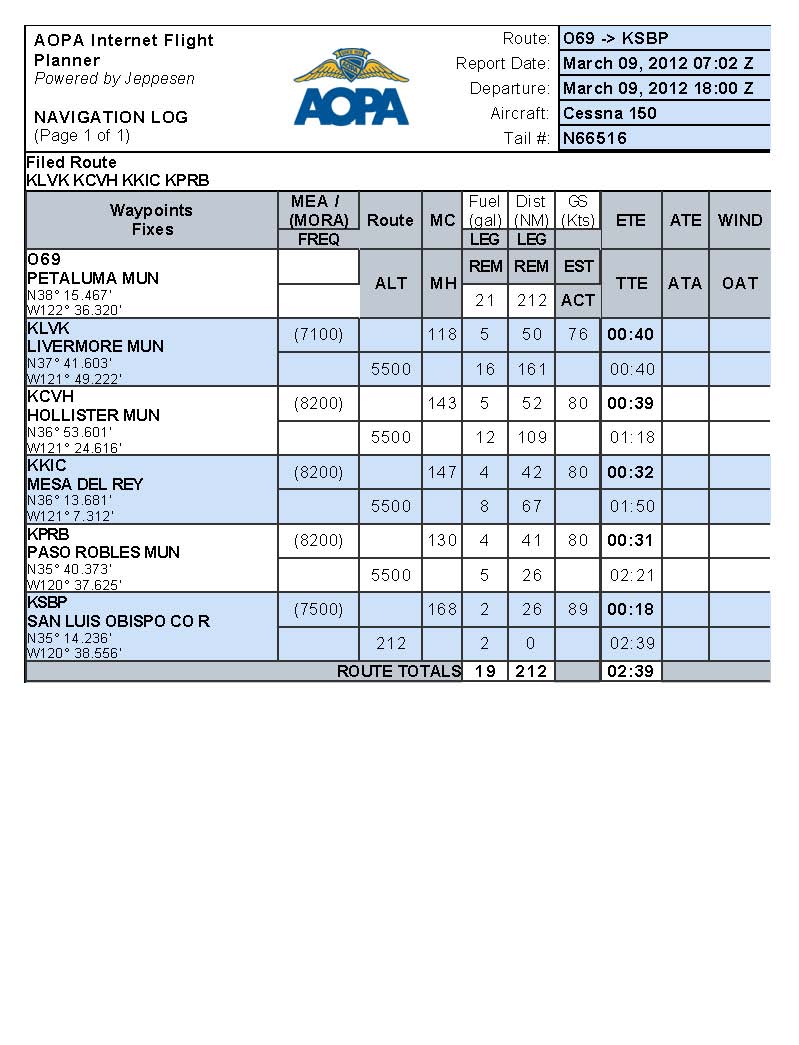
The plan in AOPA doesn't, but the same one in Foreflight does - make me want to stop for gas. If I do, I want it to be so that I am XC the whole time which means my gas will need to be 50nm from the destination.

So I will be keeping an eye on everything. The plane only has a four hour range and that does not account for taxi, runup, climb, reserve, etc. I'll decide in air whether to go to the destination or land mid way, based on our real time data.

Here is the plan so far:

6966298475_6dfde22434_o.jpg
 
Kimberly,
First, don't let logging concerns sway you from making the SAFE choice! That said, note that your flight is all XC, even if your fuel stop is within 50NM of your ultimate destination.
http://www.faa.gov/about/office_org/headquarters_offices/agc/pol_adjudication/agc200/interpretations/data/interps/2009/Louis%20Glenn.pdf said:
Section 61. 1(b)(3)(i), in relevant part, states the
general definition of cross-country time as time acquired during flight conducted in an
aircraft, by a person who holds a pilot certificate, that includes a landing at a point other than
the point of departure, and that involves the use of dead reckoning, pilotage, electronic
navigation aids, radio aids, or other navigation systems to navigate to the landing point.
Section 61.1 (b)(3)(ii), in relevant part, defines cross-country time for the purposes of
meeting the aeronautical experience for a private pilot certificate, a commercial pilot
certificate, an instrument rating, or for the exercise of recreational pilot privileges. For these
purposes, cross-country time is time acquired during a flight conducted in an appropriate
aircraft that includes a point of landing that was at least a straight-line distance of more than
50 nm from the original point of departure and that involves the use of dead reckoning,
pilotage, electronic navigation aids, radio aids, or other navigation systems to navigate to the
landing point.
Your flight include a point of landing more than 50NM from the origin, regardless of how many intermediate fuel stops you made, so it is a cross country flight for all practical purposes.

Further, from the same source
Additionally, you request clarification about whether a "repositioning" flight can be used to
change the original point of departure for calculating cross-coUntry time. In your example, a
pilot wishes to fly from Airport A to Airport B and back, but Airport B is not more than 50
nm from Airport B. To log cross-country time, the pilot flies from Airport A to Airport C as
a discreet flight. The pilot then flies a separate flight from Airport C to Airport B, which is a
straight-line distance of more than 50 nm, and from Airport B to Airport A. You ask
whether the pilot may log cross-country time for the C-B-A flight to meet the aeronautical
experience requirements under §§ 61.65(d), 61.129, or 61.159.
In the context of meeting aeronautical experience requirements under § 61.159, the
controlling definition in § 61. 1(b)(3)(vi) does not require a landing but only a flight that is at
least a straight-line distance of more than 50 nautical miles from the original point of
departure. Therefore, your scenario does not apply to the § 61.159 requirements. Regarding
the §§ 61.65(d) and 61.129 requirements, unless the pilot is attempting to meet the
aeronautical experience requirements for any pilot certificate with a rotorcraft category
rating or an instrument-helicopter rating, the controlling definition of cross-country time is §
61. 1(b)(3)(ii). There is nothing in § 61. 1(b)(3)(ii) or previous FAA interpretations dictating
how separate flights must be logged. Accordingly, the pilot may choose what is considered
a discreet flight and what is merely a segment of a flight, and then log that time
appropriately when the flight is conducted. Section 61.1 (b)(3)(ii) requires that the flight
include a landing at a point other than the point of departure. This definition does not
contain a requirement that the first leg of the flight include a landing that is more than 50 nm
distant, but it does require that one point oflanding is at least a straight-line distance of more
than 50 nm from the original point of departure. See Legal Interpretation to E. Thomas Sisk
(Mar. 18,2008); Legal Interpretation to Alfred Tenuta, Jr. (Apr. 17, 1998). Accordingly, the
pilot may log cross-country time for the C-B-A flight in your scenario if that flight is logged
as a discreet flight. Moreover, if Airport A was more than 50 nm from Airport C, which is
the original point of departure for the flight, the pilot may log this cross-country time
regardless of the distance between Airports C and B.
 
Well OK let me rephrase, I have to show up with enough emptiness in my tanks to allow them to put ten gallons in for me to park there for free for the four days. So the further away I get gas, the more empty I will be. I just don't want to fly straight there if it isn't looking like we're gonna land in three hours or less and if I took more than a few minutes to taxi, runup, and depart the pattern at Petaluma.

It is lame that I can't go even 200nm with an hour fuel reserve unless all conditions are pretty favorable. Oh well. Good fuel planning practice.
 
The plan in AOPA doesn't, but the same one in Foreflight does - make me want to stop for gas. If I do, I want it to be so that I am XC the whole time which means my gas will need to be 50nm from the destination.

So I will be keeping an eye on everything. The plane only has a four hour range and that does not account for taxi, runup, climb, reserve, etc. I'll decide in air whether to go to the destination or land mid way, based on our real time data.

Here is the plan so far:

6966298475_6dfde22434_o.jpg

Something just changed. Winds populated and it changed from 2:39 to 2:55, darn. Looks like I really should stop for gas.
 
Back
Top