You are using an out of date browser. It may not display this or other websites correctly.
You should upgrade or use an alternative browser.
You should upgrade or use an alternative browser.
Waterloo, IL Beech
- Thread starter soilboy
- Start date

Flying Keys
Cleared for Takeoff
- Joined
- Jul 2, 2021
- Messages
- 1,027
- Display Name
- Flying Keys
The Cards game they reportedly went to ended around 0238z (9:38p lcl). Wasn't super close (Cards lost 4-8) and we don't know if they stayed until the end.
Either way, it's about a 30 minute drive from Busch Stadium to St. Louis Regional in good traffic.
The flight departed Alton (KALN) a little over 45 minutes after the game ended, at 0325z (10:25p lcl), destination Siloam Springs, AR (KSLG)
The accident happened near Waterloo, IL, about 14nm SW of Scott AFB (KBLV), at 0348z, 23 mins after departure.
Here's a story in several pictures - the direct route from KALN to KSLG in magenta:
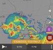
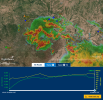
Big picture at 0200z
Big picture at 0245z
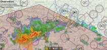
Big picture at 0330z, just after departure
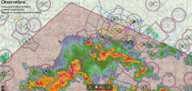
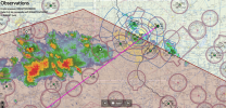
At 0345, near the time of the accident, zoomed in a bit, with the accident flight path in yellow.
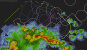
You can see just how rapidly the new cells developed ahead of the existing convection. I'm presuming that with a cruise altitude around 4500, they were trying to avoid the outer 80/45 bravo shelves on the main extended centerlines of KSTL. I added a "safer" path in green, around the back of the storms, also avoiding the similar shelves NE of KSTL.
Note that prior to and up until the time of the departure, only two airports near the route had a TAF that indicated the possibility of thunderstorms during the flight time - Scott AFB (KBLV), which isn't far from the accident site, with TSRA forecasted, and Waynesville, MO (KTBN), about halfway to the destination, with VCTS. There was a convective SIGMET for the entire region, from about 30 miles right of the direct route, extending well to the southeast, in the direction of the storm travel.
The biggest point I'm trying to illustrate is how quickly convection changes and initiates, especially downstream of an existing system.
For want of a left turn out and flying counter-clockwise around the bravo, they would have been behind the main cluster of storms and I don't think we'd be having this conversation. Or even better, they could have waited until morning - there was additional convection along and right of the direct route, near Rolla, later. At night, that would have been difficult to pick further around - they'd have needed to go all the way west to Columbia to avoid it.
Either way, it's about a 30 minute drive from Busch Stadium to St. Louis Regional in good traffic.
The flight departed Alton (KALN) a little over 45 minutes after the game ended, at 0325z (10:25p lcl), destination Siloam Springs, AR (KSLG)
The accident happened near Waterloo, IL, about 14nm SW of Scott AFB (KBLV), at 0348z, 23 mins after departure.
Here's a story in several pictures - the direct route from KALN to KSLG in magenta:
Big picture at 0200z
Big picture at 0245z
Big picture at 0330z, just after departure
At 0345, near the time of the accident, zoomed in a bit, with the accident flight path in yellow.
You can see just how rapidly the new cells developed ahead of the existing convection. I'm presuming that with a cruise altitude around 4500, they were trying to avoid the outer 80/45 bravo shelves on the main extended centerlines of KSTL. I added a "safer" path in green, around the back of the storms, also avoiding the similar shelves NE of KSTL.
Note that prior to and up until the time of the departure, only two airports near the route had a TAF that indicated the possibility of thunderstorms during the flight time - Scott AFB (KBLV), which isn't far from the accident site, with TSRA forecasted, and Waynesville, MO (KTBN), about halfway to the destination, with VCTS. There was a convective SIGMET for the entire region, from about 30 miles right of the direct route, extending well to the southeast, in the direction of the storm travel.
The biggest point I'm trying to illustrate is how quickly convection changes and initiates, especially downstream of an existing system.
For want of a left turn out and flying counter-clockwise around the bravo, they would have been behind the main cluster of storms and I don't think we'd be having this conversation. Or even better, they could have waited until morning - there was additional convection along and right of the direct route, near Rolla, later. At night, that would have been difficult to pick further around - they'd have needed to go all the way west to Columbia to avoid it.
Last edited:

- Joined
- Oct 16, 2019
- Messages
- 8,855
- Location
- Atlanta / Marietta
- Display Name
- Vintage Snazzy (so my adult children say)
- Home Airfield
- KPUJ
Note that prior to and up until the time of the departure, only two airports near the route had a TAF that indicated the possibility of thunderstorms during the flight time
Let me add to your thought here. Yes, you look at the TAF of airports on your path. But you also look at the weather in general, look at what's developing, what's coming your way, etc. If there is a large system coming your way, just go around it. And remember that in this time of year, hot and muggy summer, things will be popping up especially afternoon and evening. Don't use the ADSB Weather as if it was a weather radar and try and pick your way through it. Just don't be in a hurry. And you can always not fly and wait it out.
Flying Keys
Cleared for Takeoff
- Joined
- Jul 2, 2021
- Messages
- 1,027
- Display Name
- Flying Keys
That’s the entire point of mentioning that - TAFs, or any single source, really, don’t paint enough of a picture. There has to be a better understanding and respect for convective weather. Weather in general, to be honest.Let me add to your thought here. Yes, you look at the TAF of airports on your path. But you also look at the weather in general, look at what's developing, what's coming your way, etc. If there is a large system coming your way, just go around it. And remember that in this time of year, hot and muggy summer, things will be popping up especially afternoon and evening. Don't use the ADSB Weather as if it was a weather radar and try and pick your way through it. Just don't be in a hurry. And you can always not fly and wait it out.

Kelvin
En-Route
@Flying Keys
The daughter has stated that the weather tracking system had a "glitch".
Kelsey Lewis — who had flown with her father and brother just hours earlier — said a glitch in the aircraft’s weather-tracking system could be the reason why her family members decided to fly into the eye of the storm that night
The plane’s tracking software was 30 minutes off, which tragically led the father and son to believe they would “hit the gap” between flying into the eye of the storm and landing safely, Kelsey told the outlet.
Both of these gentlemen were pilots but neither were instrument rated.
- Joined
- Oct 16, 2019
- Messages
- 8,855
- Location
- Atlanta / Marietta
- Display Name
- Vintage Snazzy (so my adult children say)
- Home Airfield
- KPUJ
IMHO - If you want to fly X Country far enough to do things like go to a game, get IR. They may have also gotten in IMC, spatial disorientation.Both of these gentlemen were pilots but neither were instrument rated.
I found also that IR training stepped up my weather understanding and decision making.

Ed Haywood
Final Approach
Don't use the ADSB Weather as if it was a weather radar and try and pick your way through it.
Especially at night. During daytime, you can often correlate the ADS-B picture to what you actually see ahead of you. Once the sun goes down, VFR risk goes up exponentially. After a few scares over the years, I only fly at night in perfect conditions.
I'm sorry for speaking ill of the dead, but who the hell gets a twin and doesn't bother getting their IR? That's a death wish.

Sorry for being mean here, but the “planes” weather system was off? Seriously ? They didn’t have a smart phone with access to any number of weather services that they likely were looking at anyway?
Kelvin
En-Route
My guess is that the daughter had flown enough to pick up on the fact that Nexrad is delayed. This poor girl has just lost her Dad and big brother and most likely seeking an explanation. I can see this being one possibility that she might consider....albeit it is inaccurate.Sorry for being mean here, but the “planes” weather system was off? Seriously ? They didn’t have a smart phone with access to any number of weather services that they likely were looking at anyway?
- Joined
- Jul 29, 2011
- Messages
- 1,466
- Display Name
- MountainDude
- Home Airfield
- KPDX
This is a very trivial mistake due to poor planning and busy lives. The plane enabled them to go to the game, and get back just in time to get enough sleep for the next day. But that involves a hurry that can miss very important details. 
Flying Keys
Cleared for Takeoff
- Joined
- Jul 2, 2021
- Messages
- 1,027
- Display Name
- Flying Keys
Huh. Wonder which “system” that would be. FIS-B? XM? ForeFlight/Garmin Pilot on the EFB? Either way, there are times indicated on the screen that can alert you to the latency of networked radar imagery.@Flying Keys
The daughter has stated that the weather tracking system had a "glitch".
Kelsey Lewis — who had flown with her father and brother just hours earlier — said a glitch in the aircraft’s weather-tracking system could be the reason why her family members decided to fly into the eye of the storm that night
The plane’s tracking software was 30 minutes off, which tragically led the father and son to believe they would “hit the gap” between flying into the eye of the storm and landing safely, Kelsey told the outlet.
Both of these gentlemen were pilots but neither were instrument rated.
And as I illustrated above, nothing indicated on a system “stuck” in a 30 minutes prior state would have indicated safe passage for that route. Heck, nothing in the 2 hours prior would have. There’s no way they’d have gotten in front of that on the direct course. The only somewhat viable gap shot would have been if they’d departed at 0100z (2.5 hours prior) and flown more southerly, toward West Plains, MO (KUNO), before heading on course. That would maaaybe provide an extremely thin margin of passage. But at night, with no onboard radar, count me out.
Preflight prep using other sources should have indicated the intensity, location, and direction of that system as-was, which would have been enough to deter a gap shot, despite the intense initiation ahead of the existing returns that began to occur around departure time. There would have been a lot of lightning in all western and southern quadrants as well.
Albany Tom
Final Approach
- Joined
- Jul 23, 2021
- Messages
- 5,703
- Display Name
- Albany Tom
I was at an aviation safety seminar at ALB one evening where not 1 but 2 pilots in the audience argued, insisted, that all the talk of delays with ADSB weather were overblown, and that it was completely safe to use that system to fly between cells.
- Joined
- Oct 16, 2019
- Messages
- 8,855
- Location
- Atlanta / Marietta
- Display Name
- Vintage Snazzy (so my adult children say)
- Home Airfield
- KPUJ
There was an “air disasters” episode where a guy in a piper also tried that. Flew into a thunderstorm, plane broke up in air.I was at an aviation safety seminar at ALB one evening where not 1 but 2 pilots in the audience argued, insisted, that all the talk of delays with ADSB weather were overblown, and that it was completely safe to use that system to fly between cells.
- Joined
- May 15, 2020
- Messages
- 7,764
- Display Name
- Ernie
- Home Airfield
- C81
Night, weather, terrain.Especially at night. During daytime, you can often correlate the ADS-B picture to what you actually see ahead of you. Once the sun goes down, VFR risk goes up exponentially. After a few scares over the years, I only fly at night in perfect conditions.
I'm sorry for speaking ill of the dead, but who the hell gets a twin and doesn't bother getting their IR? That's a death wish.
Pick one.
Albany Tom
Final Approach
- Joined
- Jul 23, 2021
- Messages
- 5,703
- Display Name
- Albany Tom
Or call ATC. I've done it in the daytime. "Hey, we thought this was going to be a nice VFR day, but it isn't, could you find us a spot to get through this, headed west?"Sorry for being mean here, but the “planes” weather system was off? Seriously ? They didn’t have a smart phone with access to any number of weather services that they likely were looking at anyway?
Not a great primary plan, but there are way worse backup plans.
- Joined
- May 15, 2020
- Messages
- 7,764
- Display Name
- Ernie
- Home Airfield
- C81
Primary plan would have been calling 1-800-wxbrief on the way to the airport. They'll still answer and talk to you.Or call ATC. I've done it in the daytime. "Hey, we thought this was going to be a nice VFR day, but it isn't, could you find us a spot to get through this, headed west?"
Not a great primary plan, but there are way worse backup plans.
Most likely you'll get "you're vfr??.... You're freakin crazy!!"
Last edited:
Albany Tom
Final Approach
- Joined
- Jul 23, 2021
- Messages
- 5,703
- Display Name
- Albany Tom
Yeah, I think I've called to ask weather questions about 3 times total, and they've always been really friendly and helpful.Primary plan would have been calling 1-800-wxbrief on the way to the airpoy. They'll still answer and talk to you.
Most likely you'll get "you're vfr??.... You're freakin crazy!!"
Ed Haywood
Final Approach
I was at an aviation safety seminar at ALB one evening where not 1 but 2 pilots in the audience argued, insisted, that all the talk of delays with ADSB weather were overblown, and that it was completely safe to use that system to fly between cells.
I do it in day VFR all the time. Dodging cells is pretty typical flying for summer afternoons in Florida. It is usually easy to match up radar imagery with what you see in the windshield. Night or IFR, much different story.
Albany Tom
Final Approach
- Joined
- Jul 23, 2021
- Messages
- 5,703
- Display Name
- Albany Tom
If you can see and compare I can see - pun not intended - it working. But night, or when it's light rain everywhere, marginal VFR and you can't see cells or severity, it just doesn't make sense to me.I do it in day VFR all the time. Dodging cells is pretty typical flying for summer afternoons in Florida. It is usually easy to match up radar imagery with what you see in the windshield. Night or IFR, much different story.

schmookeeg
Final Approach
- Joined
- Nov 6, 2008
- Messages
- 5,812
- Location
- Alameda, CA
- Display Name
- Mike Brannigan
- Home Airfield
- KOAK
I wonder how many times they succeeded at the ol' split the cells trick in daytime.
dumb crash is dumb.
dumb crash is dumb.
- Joined
- Oct 16, 2019
- Messages
- 8,855
- Location
- Atlanta / Marietta
- Display Name
- Vintage Snazzy (so my adult children say)
- Home Airfield
- KPUJ
Or call ATC. I've done it in the daytime. "Hey, we thought this was going to be a nice VFR day, but it isn't, could you find us a spot to get through this, headed west?"
Not a great primary plan, but there are way worse backup plans.
Example: I was coming home from Chicago area to Atlanta a week ago, was on an IFR plan. Around Louisville a good sized weather cell started to pop up. I got good updates as I was approaching, asked for a deviation. The controller was very helpful, and I took the advice and flew a nice piece west off of my path to avoid. ATC: "N 1234, fly heading 250. I don't want you anywhere near this weather". Much appreciated. Added 20-30 minutes to flight - which is why you have reserves and then some.
Another example: Last year wife and I flying back from visiting friends in Illinois. Was about 20 minutes from our home airport, and weather popped up. Quite turbulent, etc., so I turned 180 degrees to get back to blue skies, and after a minute responded to ATC's calls. I informed I was diverting. We ended up landing a bit from home, but tied down and paid a nice Uber guy to drive us the rest of the way. Or we would have found a hotel for the night.
Summary Thoughts (repeating some themes here): If you're flying trips like the accident pilot was, 1) get your IFR, and 2) at least get Flight Following. Failing that just call up the ATC and ask about weather if you see it could be an issue. Above all else, before you even get in car to airport take a look at what weather is marching across the state headed at you.
Last edited:

This ^Or call ATC. I've done it in the daytime. "Hey, we thought this was going to be a nice VFR day, but it isn't, could you find us a spot to get through this, headed west?"
Did the same a few years ago, on the way to OSH.
Could see stuff building up on NEXRAD, asked ATC for a route around and they kept us a safe distance away.