VOR A timed approaches

UngaWunga

Pattern Altitude
Joined
Oct 27, 2014
Messages
2,265
Display Name
UngaWunga
Home Airfield
7B3
If you're flying a timed VOR A approach, when the time is up for your ground speed indicated on the chart, where should you be? Or more precisely, where does the TERPS/FAA expect you to be. Over the center of the airport? Somewhere within the 1.3nm of the end of a runway? Somewhere in between?
 
If you're flying a timed VOR A approach, when the time is up for your ground speed indicated on the chart, where should you be? Or more precisely, where does the TERPS/FAA expect you to be. Over the center of the airport? Somewhere within the 1.3nm of the end of a runway? Somewhere in between?
Near the Missed Approach Point. What the exact limits are I dunno, 1.3nm sounds about right. @RussR ??
 
Near the Missed Approach Point. What the exact limits are I dunno, 1.3nm sounds about right. @RussR ??
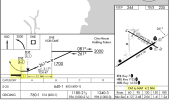
Timing only and no DME? At the MAP and the MAP is typically runway threshold. For example, this is the SAF VOR 33.
(Yes the approach has a DME arc, but it's optional. The approach doesn't require DME.)

1772999065577.png
 
@UngaWunga, I didn't have to go as far as Santa Fe NM. In your area, look at the chart for the VOR25 at SFM. The timing table isn't magic. It's just a basic RxT=D calc using groundspeed and the distance between the FAF and the MAP.

1772999557862.png
 
Last edited:
Timing only and no DME? At the MAP and the MAP is typically runway threshold. For example, this is the SAF VOR 33.
(Yes the approach has a DME arc, but it's optional. The approach doesn't require DME.)

View attachment 150625
Yeah. A lot is going to vary. The OP said a VOR A Approach. That could be coming in at a 90 degree angle. Or it could be aligned straight in but was to steep for straight in minimums. @UngaWunga , is there a particular Approach you are wondering about? And what airplane are you flying? Is it an Approach Category A plane?
 
Yes. I've done both the VOR 25 into Sanford KSFM a ton of times, and get it that the MAP is the end of the runway there.
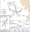
Now that I'm looking at the VOR A into KCON Concord, NH, I see its the same. https://skyvector.com/files/tpp/2602/pdf/00095VA.PDF
That's a fun one, BTW, with a rather steep descent after the FAF to MAP.
I've been told that the timing should take you to various points at the airport for circling to a runway. But now that I just look at the chart and think for a second, the MAP makes a little more sense.

I guess the question is more around it being a VOR approach to the airport area so that you can generally circle to a runway that may not be 12 and mostly aligned with the approach course.
 
Last edited:
There's nothing mystical about it. The timing table is simply the distance from the FAF to the MAP, divided by the table's groundspeed. Now, if the question is "where is the MAP, since some procedures don't show it (if there's no DME to measure it)", well, in the timing table itself it shows the FAF to MAP distance used for the calculation. The MAP for such an approach will usually be abeam the nearest landing surface as you come down final (if the MAP is the facility, there's no need for a timing table).

But remember, the time is based on your estimate of groundspeed, since we're presuming no RNAV here. So there is quite a bit of "slop" in the protected area to account for this. I forget what it is, but yeah, something like a mile seems right.
 
If you're flying a timed VOR A approach, when the time is up for your ground speed indicated on the chart, where should you be? Or more precisely, where does the TERPS/FAA expect you to be. Over the center of the airport? Somewhere within the 1.3nm of the end of a runway?

Distance of VOR to MAP, error of VOR receiver, how accurately the approach is flown and how accurate your ground speed guess goes into the result.

The VOR\DME approaches can be >25 nm from the VOR to MAP and the errors quite substantial. I seem to recall the protected area is 4 nm.
 
Last edited:
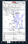
You could use DME identify XUDAJ but it’s not necessary. Jepp goes to the trouble to let you know this.
Somehow, I can tell both of those things just fine on the FAA charts and, as usual, don't see significant difference between the two (although there is that thing about Jepp not including the MAHP in the iconized missed approach when there is an intermediate fix on the missed).
 
Somehow, I can tell both of those things just fine on the FAA charts and, as usual, don't see significant difference between the two (although there is that thing about Jepp not including the MAHP in the iconized missed approach when there is an intermediate fix on the missed).
Yeah, I showed the Jepp chart to help reinforce that to the OP who had thought at first that DME was required. On the MAHP thing, Jepp puts it on the Planview along with Alternate Missed Approach Fix. Doing it on the ‘iconized’ missed approach depiction would be redundant.
 
Yeah, Jepp does a better job of specifically marking the (non-precision) MAP. It's implied on the FAA charts.
 
Yeah, Jepp does a better job of specifically marking the (non-precision) MAP. It's implied on the FAA charts.
Jepp does have that M. With that bold line, both of them kinda make it look it’s at the threshold of a runway which isn’t true
 
Yeah, I showed the Jepp chart to help reinforce that to the OP who had thought at first that DME was required. On the MAHP thing, Jepp puts it on the Planview along with Alternate Missed Approach Fix. Doing it on the ‘iconized’ missed approach depiction would be redundant.
Really? So, when the Jepp chart does show it (when there is no intermediate fix), you think it's redundant redundant? And since the missed procedure is written out at the top, isn't the whole inconization thing redundant? Sounds like Jepp Kool-Ade to me :D (I've been equally comfortable with both depictions for almost as long as I've been rated.)
 
The VOR\DME approaches can be >25 nm from the VOR to MAP and the errors quite substantial. I seem to recall the protected area is 4 nm.

The formula for VOR final primary area half-width is .05D+1. Maximum distance from the VOR to the MAP is 30 nm. So the maximum primary area half-width is .05(30)+1 = 2.5 nm. Half width, so the full width is 5.0 nm. Yeah, pretty wide.

Now, an approach with a MAP 30 nm from the facility is probably not going to have a very low MDA, since the signal may not be usable that low that far away. So the MDA may have to be artificially increased just to get enough usable signal.
 
The formula for VOR final primary area half-width is .05D+1. Maximum distance from the VOR to the MAP is 30 nm. So the maximum primary area half-width is .05(30)+1 = 2.5 nm. Half width, so the full width is 5.0 nm. Yeah, pretty wide.
I’m curious. Does that formula account for the 6°VOR error tolerance?
 
I’m curious. Does that formula account for the 6°VOR error tolerance?

I was about to say "yes, it accounts for all those factors", but I just did the math, and I can't say it does.

At 30 nm, the half-width is 2.5 nm. That calculates to being 4.76 degrees off the published course.

Now, there is a secondary area, but that's only 0.333D wide. So at 30nm, it's an additional 1 nm wide.

Total width of 3.5 nm, which equals 6.65 deg off course. Which seems like enough, just barely, but the obstacle clearance on the secondary area tapers down to literally zero at the edge.

But on the other hand, I think that the primary area is supposed to provide protection for the 95th percentile determined through studies, or wording similar to that. Now, keep in mind that's "reasons behind TERPS", not TERPS itself, and I have no actual training in the "reasons", just the application. Also, keep in mind that VOR criteria is very, very old and hasn't changed in a long, long time as there is no obvious need or impetus to do so.

 
Back
Top