Van's RV-10 fatal crash N626PB in Simi Valley / Ventura County CA

RV10 reportedly.
 
Juan touched on this awhile ago about private planes hitting houses on the ground. We seem to have more and more of these incidents. The RV going into the industrial factory and injuring factory workers. Simple fact that there is a lot more houses built around airports than years ago.
Will we see pushback from the FAA on this especially the home built aircraft markets that have exploded with more and more aircraft being built?
 
Will we see pushback from the FAA on this especially the home built aircraft markets that have exploded with more and more aircraft being built?
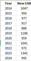
Actually, "production" of homebuilt airplanes has been pretty constant.
1746368624592.png
"New EAB" refers to newly-registered homebuilts each year, it's not the net change. The net increase over the 2014-2024 time period is only about 900 aircraft.

Ron Wanttaja
 
Juan touched on this awhile ago about private planes hitting houses on the ground. We seem to have more and more of these incidents. The RV going into the industrial factory and injuring factory workers. Simple fact that there is a lot more houses built around airports than years ago.
Will we see pushback from the FAA on this especially the home built aircraft markets that have exploded with more and more aircraft being built?
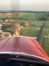
It’s a function of people building more and more houses around airports that used to be on the edges of town. It’s so maddening when people intentionally build in places that create new hazards. I’ve attached a picture of short final for the old O’Brian field south of Dallas. The airport was there before those new houses. It’s so maddening.

I think that excessive urbanization is a plague. We still need a few fields and pastures in and around cities.
 

Attachments

  • IMG_7341.jpeg
    IMG_7341.jpeg
    1.4 MB · Views: 98
Last edited:
So... some thread drift here, and there's a high chance I'm saying dumb things, but here's a question for the airport managers on this board:

As airports get encroached by developers and their land value increases, does it make any sense (practical/financial) to consider selling on the peak and using the money to build another airport some reasonable distance away, where it will be safe (and allow safe operations) for another 50 years?
Doubtful. Only really works for privately owned airports. Any land not being encroached is going to be far enough away it would be in a different municipality. Plus in a less populated area where every user is going to have to travel further. Land acquisition anywhere is going to significantly eat into the sale price. Then spend 8 figures to build to what you already had

For the privately owned airports. One idea I had heard that could prevent it from being sold by the whims of one owner is diversity. Rather than lease hangar. Sell it and the owner of the hangar is now an airport owner/board member. Much harder to get 50 people with a vested interest to agree to sell than it is 3 or 4 elected officials.

It's actually something dad was trying to do at our airport that is/was/may still be for sale.
 
Last edited:
Our airpark is set up to prevent a shutdown. One of the first covenants states that as long as one owner (we have 65 lots) wants to keep it as an airport, then it remains so. True, the convenants could be changed, but that requires a 75% affirmative vote of all the owners, so they’d have to get 49 owners to vote in favor of it.
 
The data tell a pretty familiar story:

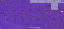
Path with Wx overlay.JPG

Cloud forecast at the time:

Forecast clouds 2045z.JPG

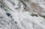
Visible Satellite:

1746384382640.png

Orthogonal view of the final flight path:

1746384470047.png

Took about two and a half minutes (150 seconds) for the flight path to go from seemingly under control to the accident.
 
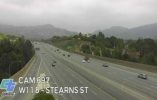
Here's a traffic cam from the 118 near Santa Susana (about 7nm from from the accident site) at the time of the accident, looking east (away from the accident site):

1746385492556.png

Gives an idea of the local conditions. The peaks in the left and right background are at about 2100' MSL. Ceilings were forecast to be about 2300 MSL in that area, lowering to 1500-1600 (interpolated) near the accident site, which was at around 1000-1100 MSL.
 
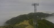
Another good view from (edit: a few hours before) the accident, this from the LA County Fire Dept Camp 9, roughly 20nm to the east, looking west toward the accident area. The camera is situated at around 4000' MSL, The top of the layer in this area seems to be a little ragged, between 3400-3600' MSL. The peak sticking out in the distance is at about 3550'. Take this with a little grain of salt as there are several microclimates that can change this quite a bit in that 20nm, but it should give a rough idea. Note the layers above as well.

1746386337098.png
 
Last edited:
The data tell a pretty familiar story:
Not so sure it’s that cut and dry. According to FlightAware history, this pilot flew IFR pretty regularly. It doesn’t look like the typical VFR into IMC scenario. It was relatively benign IFR conditions at the time. I’m curious what avionics he had. Perhaps an issue there?
 
I would look at airframe icing. Perfect conditions for that over the mountains. It might explain the control problems and a resultant stall.
 
Not so sure it’s that cut and dry. According to FlightAware history, this pilot flew IFR pretty regularly. It doesn’t look like the typical VFR into IMC scenario. It was relatively benign IFR conditions at the time. I’m curious what avionics he had. Perhaps an issue there?

The familiarity is the loss of control. The cause is unknown. If the clouds weren't there, would the resultant flight path look like that?

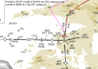
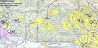
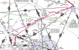
It was on an IFR flight plan - PMD V386 FIM FIM132 COOGA. The crash happened almost exactly after COOGA. Need to find the ATC tapes to see if it was cleared direct at some point, but here's the filed plan in magenta with the actual flight path overlaid in red (note it did cross SESPE, which was not in the filed plan, so it's very possible there was a change):

1746390914036.png

Note also that FIM to COOGA is a feeder segment for the VOR Rwy 26 into CMA, for which COOGA is a HILPT and IAF
SESPE is an IAF for the RNAV Y and Z into rwy 26 at CMA
 
The posts over on VAF have now been removed (no speculation allowed) but it was posted that apparently based on LiveATC he requested and was cleared for the RNAV Z to 26. All transmissions were normal until he then requested vectors stating the aircraft kept turning on him.
 
Last edited:
Ah, answered my own question - here's the tape from Mugu Approach:


Q&D summary (times are from the beginning of the recording at ~2030Z - "NTD" is Mugu Approach):

14:05 N626PB checks in with information Tango at CMA
14:15 N626PB requests RNAV Z
14:25 NTD responds "...6 from JUREX, cross JUREX at 4,000', cleared RNAV Z 26 approach"
The response to that was a little unclear, the only intelligble part to me was "cleared RNAV Z 26 approach"
16:37 NTD asks 626PB to maintain current speed or better for traffic - response "PB"
17:25 NTD asks 6PB to say current altitude, then "radar contact lost" a few seconds later - no response
17:43 NTD asks for a radio check, 626PB responds "626PB"
17:48 NTD indicates they're having trouble hearing 626PB and asks for altitude - 626PB responds "come again 626PB?"
17:59 NTD asks for 626PB to say altitude. No response
18:09 NTD states that 626PB should be at 4000 on the RNAV Z. No response
18:40 NTD "626PB Mugu Approach." No response
19:11 NTD "626PB Mugu Approach, radio check."
19:13 626PB " Yeah, I need some vectors, the plane keeps turning on me"
19:20 NTD "626PB Roger, say altitude"
19:27 626PB "(unintelligble) one-hundred"
19:29 NTD "and, uh, 6PB, you're coming in broken and unreadable, say again." No response
19:46 NTD "N626PB, Mugu Approach"
19:51 626PB "thousand"
19:54 NTD 626PB, you are radar contact lost, I do not have you on my scope, and uh..." No response
20:03 NTD "6PB, if able, remain below 5000." No response
20:30 NTD "6PB, uh say current altitude." No response
21:11 NTD "N626PB Mugu Approach." No response
21:25 NTD "N626PB Mugu Approach." No response
21:50 NTD "N626PB Mugu Approach, radio check." No response

NTD makes several more attempts to establish comms over the next 5 minutes with no response. They enlist an approaching Cirrus to try to establish comms, which it does twice with no response

Here's the approach with the flight path overlaid. I'm going to leave the filed FIM-COOGA segment intact for reference, even though it's not part of the approach:

1746392065849.png
 
I would look at airframe icing. Perfect conditions for that over the mountains. It might explain the control problems and a resultant stall.
Doubtful. The freezing level was around 10,000' over the accident site, higher to the east, where the flight originated. This flight never went over 8,000, and that was only briefly, early on. The latter half of the flight was at 6,000 or below.
 
Even a seasoned instrument pilot can get a bad case of vertigo if he keeps being turned around by (my speculation here) a bad or misconfigured autopilot. Or a runaway trim servo.
 
I'm going to add that based on the communications and ADS-B timestamps, that the ADS-B track stops a minute or so short of the accident, which happened about 1/2 mile north of the last pinged point.
 
Perhaps mode selection. Autopilot HDG, NAV, APPROACH MODE sequencing ? Could explain aircraft “turning” on him.
 
Person used to only flying in the soup with the autopilot and it failed on him this time for some reason (either it was malfunctioning or he didn't actually program it to fly the approach right).

Much as I like my autopilot I like my moving map more. For currency I always do each approach twice, one with the autopilot and one hand flown. The last thing I want to have happen in the clag is me wondering WTF is this thing doing.
 
I also found him on SOCAL’s Woodland sector.

In accordance with the timeline established above,

At T+4:56 6PB tells SOCAL (unsure if a response or a check-in) they are descending to 6000’

At T+5:02 SOCAL tells 6PB to proceed direct SESPE then direct somewhere that was unintelligible. 6PB responds “proceed direct where? 6PB.” SOCAL tells him SESPE is the IAF for the RNAV. 6PB responds “Ah, I have it, proceed direct SESPE, 6PB”

At T+7:28 SOCAL descends 6PB to 5000

At T+13:52, SOCAL descends him to 4000 and hands him off to Pt Mugu. Note that in the recordings I found, there was no evidence prior to this point of an “expect approach” or a clearance other than saying SESPE was the IAF.

When he contacted Mugu Approach, he was basically right over SESPE, give or take (the turn was a flyby). Mugu then gave him a PTAC (without the turn) for JUREX, which is an IF, and the approach clearance. The flightpath already showed him in the turn to JUREX prior to reaching SESPE - the timing of the instructions from ATC could use further verification.

Pure speculation from this point, but there could be approach sequencing goofiness with whatever navigator he was using. If I’m up there and I’m given direct to the IAF and no further approach clearance, I start to consider how I’m going to sequence this in the navigator. VTF most likely, but it could be that he already started the turn to JUREX as if he was going to the full procedure from SESPE. Either way, it should sequence, but maybe the approach wasn’t entered or activated?

Interestingly, the path is really smooth until it starts to wobble halfway between SESPE and JUREX, right around where COOGA (not part of the approach) just happens to be. Perhaps COOGA was still in the sequence after SESPE? Lots of possibilities, very hard to point a finger - even if it’s not related, at this point I’m just doing an academic exercise to consider how different navigators might behave in these scenarios and drilling, once again, all these little variables that can throw wrenches in what we expect, what we enter, and what we get.
 
I’ve flown with a couple guys who love using the autopilot, even VFR in perfect VMC on half-hour flights. And when the AP does something unexpected, they’ll keep adjusting it, change settings, amd try to keep up with whatever unintended turn or climb it’s doing. The last thing they’re willing to do is disconnect and hand fly.
 
The last thing they’re willing to do is disconnect and hand fly.
I'm sure it depends in the individual, but in VMC I would probably do the same, especially if I have another pilot with me. That way I learn any autopilot/navigator quirks and how to fix them.
In IMC I'd hit the disconnect button.

But I agree, people get fixated on things going wrong. Three pilots staring at a burnt gear bulb and allowing the CFIT to happen.
 
In my opinion... if you have the habit of always keeping the Heading bug synced to current course, a better SOP than disengaging the autopilot is to simply hit HDG mode (and likely, ALT hold)... or if equipped, hit the blue LVL button. Then -- without having to hand fly at the same time -- start to troubleshoot what went wrong (quite likely something pilot-induced).
 
Even a seasoned instrument pilot can get a bad case of vertigo if he keeps being turned around by (my speculation here) a bad or misconfigured autopilot. Or a runaway trim servo.
It looks to me like he was probably hand flying at the end. Small deviations around the course. And there were some bigger deviations earlier...

Here's the interactive pressure-adjusted track... and relevant METARs (OVC 2500 decreasing 1800'):

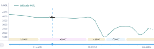
... and the altitude profile over the final 2 minutes:
View attachment 140695
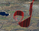
Hitting the 3D map and playing back from the start of the descent in the middle there... Yikes! He was likely within a wingspan of the ground at least twice before the final crash.

I don't know if it's me but the pilot does sound somewhat impaired, possible CO poisoning?
The track at the end does seem odd, plus the earlier deviations over the mountains... Maybe that's where the "turning" thing first happened though?

This is definitely not as cut and dried as it might seem at first glance.
 
I thought the retraction/clarification was done well (as these things go).
Yeah, as it was a retraction that really wasn't. Regardless of how hardass lawyers are, we know that the likely cause is the likely cause.
(I foresee a ruling in the not-to-distant future that says that online writings are opinions by default, unless stated as being fact.)
 
The prelim report is out, but doesn’t really shed much light.
 
Back
Top